 Umma Shown within Iraq | |
| Location | Dhi Qar Province, Iraq |
|---|---|
| Region | Mesopotamia |
| Coordinates | 31°40′02″N 45°53′15″E / 31.66722°N 45.88750°E |
| Type | Settlement |
| Site notes | |
| Excavation dates | 1854, 1885, 1999-2002, 2017-2019 |
| Archaeologists | William Loftus, John Punnett Peters, Nawala Ahmed Al-Mutawalli, Drahoslav Hulínek |

Umma ( Sumerian: 𒄑𒆵𒆠 umma KI; [1] in modern Dhi Qar Province in Iraq, was an ancient city in Sumer. There is some scholarly debate about the Sumerian and Akkadian names for this site. [2] Traditionally, Umma was identified with Tell Jokha. More recently it has been suggested that it was located at Umm al-Aqarib, less than 7 km (4.3 mi) to its northwest or was even the name of both cities. [3] [4] One or both were the leading city of the Early Dynastic kingdom of Gišša, with the most recent excavators putting forth that Umm al-Aqarib was prominent in EDIII but Jokha rose to preeminence later. The town of KI.AN was also nearby. [5] KI.AN, which was destroyed by Rimush, a ruler of the Akkadian Empire. There are known to have been six gods of KI.AN including Gula KI.AN and Sara KI.AN. [6]
The tutelary gods of Umma were Sara and Ninura. It is known that the ED ruler Ur-Lumma built a temple to the god Enki-gal and one to the god Nagar-pa'e at Umma. [7]
In the early Sumerian literary composition Inanna's descent to the netherworld, Inanna dissuades demons from the netherworld from taking Shara, patron of Umma, who was living in squalor. [8]
History
The site was occupied at least as far back as the Uruk period. A number of proto-cuneiform came from there. While most early textual sources are from Early Dynastic III, a few tablets and a plaque from ED I/II came from there. [9]
Early Dynastic period

Because the two sites were not excavated until modern times, based on the many looted texts available to them, earlier archaeologists grouped together the ancient cities during the Early Dynastic period of Gišša and Umma into the single geographic name of Umma. Modern excavation at these sites has clarified that. [2] Gišša ceased occupation after the ED and only one ruler is known, based on a lapis lazuli bead reading "To the goddess Inanna, Aka, king of Gišša (dedicated this bead)". [7]
Best known for its long frontier conflict with Lagash, as reported c. 2400 BC by Entemena, [10] [11] the city reached its zenith c. 2350 BC, under the rule of Lugal-Zage-Si who also controlled Ur and Uruk.
Sargonic period

Under the Akkadian Empire Umma was a major power and economic center rivaled only by Adab and Uruk. Eleven governors under Akkad are known as well as two who may have been under Gutium. One, Lu-Utu, reports building a temple for Ninhursag and another for Ereshkigal. Namahni, a governor from the time of Iarlagan of Gutium, records building the E-ula temple of Ninura. [12] [13] The Sargonic period ruler of Umma Lugalanatum built the temple E-gidru there.
" Lugalannatum prince of Umma... built the E.GIDRU [Sceptre] Temple at Umma, buried his foundation deposit [and] regulated the orders. At that time, Si'um was king of Gutium." [13]
Ur III period

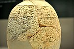
Under the Ur III dynasty, Umma became an important provincial center. Several governors of Umma under Ur are known, Aa-kala, Dadaga, and Ur-Lisi, all sons of one Ur-Nigar, and Ninbilia, wife of Aa-kala. [14] [15] [16] Most of the over 30,000 tablets recovered from the site are administrative and economic texts from that time. [17] They permit an excellent insight into affairs in Umma. [18] A year name of Ur III ruler Shu-Sin was "Year Shu-Sin the king of Ur built the temple of Shara in Umma". The next ruler Ibbi-Sin also had a year name of "Year Ibbi-Sin the king of Ur built the temple of Shara in Umma". The Umma calendar of Shulgi ( c. 21st century BC) is the immediate predecessor of the later Babylonian calendar, and indirectly of the post-exilic Hebrew calendar.
In the following Isin-Larsa period, a ruler of Larsa, Sumuel (c. 1894-1866 BC), lists as one of his later year names "Year Umma was destroyed".
Archaeology
Tell Jokha

The site of Tell Jokha was visited by William Loftus in 1854 and John Punnett Peters of the University of Pennsylvania in 1885. Peters found it to be half covered with sand dunes and found fragments of worked stone and copper fragments. [19] [20] In the early 1900s, many illegally excavated Umma tablets from the Third Dynasty of Ur began to appear on the antiquities market. [21] From 1999 to 2002 Jokha was worked by an Iraqi team led by Nawala Ahmed Al-Mutawalli, recovering a number of tablets and bullae from the Early Dynastic, Sargonic, Ur III, and Old Babylonian periods as well as an Ur III period temple and Old Babylonian residences. The cuneiform tablets are in the process of being published. [22] [23] [4] [24] [25] In 2016, a team from the Slovak Archaeological and Historical Institute led by Drahoslav Hulínek began excavations at Tell Jokha focusing on the Temple of Shara. A trench (Trench 1) excavated in 2016 showed the temple had two construction phases (Level 3 and 4). Level 4 is thought to date from the Old Akkadian period. In 2017 a square at the top (Trench 2) of the tell was opened, amidst numerous looter holes, and at Level 5 found Early Dynastic construction. In 2019 and 2020 eighteen cuneiform tablets from the Old Babylonian, Ur III, Old Akkadian and Early Dynastic periods were found in Trench 2, three in situ. A topographic survey showed that in the Early Dynastic period Umma reached an area of 400 hectares, with a 40 hectare city center. [26] [27]
Umm al-Aqarib (Gišša)

The site of Umm al-Aqarib (located at 45.80°E longitude and 31.60°N latitude) lies about 6 kilometers southeast of Tell Jokha, covers about 5 square kilometers and is made up of 21 mounds the largest of which is 20 meters above the level of the plain. It is thought to be the ancient city of Gišša and was abandoned after the Early Dynastic period. The location was first visited by John Punnett Peters in the late 1800s, finding it relatively free from sand and featuring two prominent elevations of baked bricks set with bitumen. [20]It was excavated for a total of 7 seasons in 1999–2002 (led by Donny George Youkhanna and Haider A. Urebi) and 2008–2010 (led by Taha Kerim Abod) under difficult conditions. [28] [29] At Umm al-Aqarib, archaeologists uncovered levels from the Early Dynastic Period (c. 2900–2300 BC), including residences, palaces, and several monumental buildings, including two Early Dynastic temples (the White Temple and Temple H). About 70 "cuneiform sources" were also excavated. [30] [31] [32] [33] The tutelary god is thought to be Ama-usum-ga/Usumgal-ana. [34]
Tell Shmet

The site of Tell Shmet (also Tell Schmidt and Tell Shmid) also lies nearby, around 10 kilometers to the northwest of Umma and within visual distance of Zabala. It is on the banks of the eastern branch of the Euphrates river just above the canal leading to Zabala. It was part of the Umma province in the Ur III period. The site measures 990 by 720 meters (712,800 square meters). The main Sargonic and Ur III remains of the site were destroyed by a Ministry of Agriculture program to plant trees so as to prevent sand dunes. In response to looting which began in 1994 the Iraqi State Board of Antiquities and Heritage conducted salvage excavations in 2001 and 2002 under Mohammad Sabri Abdulraheem. [35] [36] [37] [38] All of the paper records of the excavation were lost in looting of residential areas after the 2003 war. Plano-convex bricks and a residential area of the Early Dynastic III and Akkadian periods were uncovered. Finds included 67 clay cuneiform tablets, dozens of cylinder seals, and a number of stone and metal objects. The tablets mostly date ED III with the latest being Ur III. The tablets support the proposal that the ancient name of the site was Ki.anki. They mention the names of the gods Ninazu and Dumuzi-Maru. Only some of the tablets have been published. [39]
Previous textual analysis had indicated that KI.AN was very near to Zabala. During the reign of Rimush, second ruler of the Akkadian Empire, KI.AN, under its governor Lugal-KA, joined a regional revolt and was defeated. [40] In the Ur III period KI.AN had an ensi (governor). In that period it is known to have had a temple to the deified ruler Shulgi (called "e-dSulgi-ra") as well as temples to the gods Šara, Ninurra, Amarsuena, Geštinanna, Dumuzi, Gula, Ninlagaša, and Nine'e. [41] [42] [43]
Looting
During the 2003 invasion of Iraq, after Coalition bombing began, looters descended upon the site which is now pockmarked with hundreds of ditches and pits. The prospects for future official excavation and research were seriously compromised in the process. [44] In 2011, Global Heritage Network, which monitors threats to cultural heritage sites in developing nations, released aerial images comparing Umma in 2003 and 2010, showing a landscape devastated by looters' trenches during that time—approximately 1.12 square km in total. [45] Confiscated Umma area cuneiform tablets continue to make their way to the Museum of Iraq, including a group of 1500 in 2009. [46]
Rulers of Umma
First Dynasty of Umma
| Ruler | Proposed reign | Notes | |
|---|---|---|---|
| Pabilgagaltuku | c. 2500 BC | A governor of Umma, he was captured by Ur-Nanshe of Lagash. [47] | |
|
Ush ("Ninta") |
|
c. 2450 BC | Attacked Lagash and removed the boundary stone set up by Mesilim, and was defeated by Eannatum. [47] |
| Enakalle |  |
c. 2440 BC | Made a boundary treaty with Eannatum. [48] |
| Ur-Lumma |
|
c. 2430 BC | Son of Enakalle. Challenged Enannatum I, but was defeated by his successor Enmetena. [48] [47] |
| Il |
|
c. 2420 BC | Successor to Ur-Lumna. He rebelled against Enannatum II, and destroyed the dynasty of Ur-Nanshe. [48] |
| Gishakidu |
|
c. 2410 BC | Son of Il [47] |
| Edin | c. 2400 BC | Ruler of Umma [47] | |
| Me'annedu | c. 2400 BC | Ruler of Umma, reigned at least 29 years [47] [49] | |
| Ushurdu? | c. 2370 BC | Ruler of Umma [47] | |
| Ukush |
|
c. 2360 BC | Father of Lugal-Zage-Si. [47] |
| Lugal-Zage-Si |
 |
c. 2350 BC | Conqueror of all Sumer, founder of the third dynasty of Uruk, vanquished by Sargon of Akkad. [47] |
Second Dynasty of Umma
| Ruler | Proposed reign | Notes | |
|---|---|---|---|
| Lugalanatum |
|
c. 2120 BC | Vassal to the Gutian Dynasty. [47] |
Gallery
-
![Stele of Ushumgal, 2900-2700 BC. Probably from Umma.[50]](https://upload.wikimedia.org/wikipedia/commons/thumb/6/65/Stele_of_Ushumgal_MET_DT849.jpg/118px-Stele_of_Ushumgal_MET_DT849.jpg) Stele of Ushumgal, 2900-2700 BC. Probably from Umma. [50]
Stele of Ushumgal, 2900-2700 BC. Probably from Umma. [50] -
-
![Votive plaque offered by Bara-irnun, queen of Umma, to God Šara in gratitude for sparing her life. Date c. 2370 BC.[51]](https://upload.wikimedia.org/wikipedia/commons/thumb/0/05/Votive_plaque_of_a_beard-IMG_6857.JPG/100px-Votive_plaque_of_a_beard-IMG_6857.JPG) Votive plaque offered by Bara-irnun, queen of Umma, to God Šara in gratitude for sparing her life. Date c. 2370 BC. [51]
Votive plaque offered by Bara-irnun, queen of Umma, to God Šara in gratitude for sparing her life. Date c. 2370 BC. [51]
![Stele of Ushumgal, 2900-2700 BC. Probably from Umma.[50]](/info/en/?search=File:Stele_of_Ushumgal_MET_DT849.jpg)

![Votive plaque offered by Bara-irnun, queen of Umma, to God Šara in gratitude for sparing her life. Date c. 2370 BC.[51]](/info/en/?search=File:Votive_plaque_of_a_beard-IMG_6857.JPG)


See also
References
- ^ "ORACC – Umma".
- ^ a b Lambert, W. G. (1990). "The Names of Umma". Journal of Near Eastern Studies. 49 (1): 75–80. doi: 10.1086/373421. ISSN 0022-2968. JSTOR 544410. S2CID 162374749.
- ^ Bartasch, Vitali (2015). "On the Sumerian City UB-meki, the Alleged "Umma"". Cuneiform Digital Library Bulletin. 2. ISSN 1540-8760.
- ^ a b Almamori, H. O., "Gišša (Umm Al-Aqarib), Umma (Jokha), and Lagaš in the Early Dynastic III Period", Al-Rafidan 35, pp. 1–37, 2014
- ^ Marek Stępień, "The Economic Status of Governors in Ur III Times: An Example of the Governor of Umma", Journal of Cuneiform Studies, vol. 64, pp. 17–30, 2012
- ^ Peat, J. A., "An Offering - List from the Third Dynasty of Ur", Revue d’Assyriologie et d’archéologie Orientale, vol. 69, no. 1, pp. 19–22, 1975
- ^ a b Frayne, Douglas, "G͂iša and Umma", Pre-Sargonic Period: Early Periods Volume 1 (2700-2350 BC), University of Toronto Press, pp. 357-368, 2008 ISBN 978-0802035868
- ^ "Inana's descent to the nether world". Electronic Text Corpus of Sumerian Literature. Retrieved 2021-07-22.
- ^ Uruk period proto-cuneiform tablets from Umma
- ^ [1]Carrie Hritz, "The Umma-Lagash Border Conflict: A View from Above", The Umma-Lagash Border Conflict: A View from Above, From Sherds to Landscapes: Studies on the Ancient Near East in Honor of McGuire Gibson, Studies in Ancient Oriental Civilization 71, Chicago: The Oriental Institute, pp. 109-130, 2021 ISBN 978-1-61491-063-3
- ^ Cooper, Jerrold S. (1983). Reconstructing history from ancient inscriptions : the Lagash-Umma border conflict. Malibu: Undena Publications. ISBN 0-89003-059-6. OCLC 10304478.
- ^ Foster., Benjamin R., "Archives and Record-keeping in Sargonic Mesopotamia", Zeitschrift für Assyriologie und Vorderasiatische Archäologie , vol. 72, no. 1, pp. 1-27, 1982
- ^ a b [2]Douglas R. Frayne, "Umma", The Sargonic and Gutian Periods (2334–2113), University of Toronto Press, pp. 261-268, 1993 ISBN 0-8020-0593-4
- ^ Frayne, Douglas, "Table III: List of Ur III Period Governors", Ur III Period (2112-2004 BC), Toronto: University of Toronto Press, pp. xli-xliv, 1997
- ^ T. Maeda, "Father of Akala and Dadaga, governors of Umma", ASJ 12, pp. 71 - 78, 1990
- ^ P. A. Parr, "Ninhilia: Wife of Ayakala, Governor of Umma", JCS 26, pp. 90 – 111, 1974
- ^ [3]I. J. Gelb, "Sargonic Texts in the Louvre Museum", Materials for the Assyrian Dictionary 4, Chicago: The University of Chicago Press, 1970 ISBN 978-0-22-662308-5
- ^ Parr, P. A. (1972-06-01). "A Letter of Ur-Lisi, Governor of Umma". Journal of Cuneiform Studies. 24 (4): 135–136. doi: 10.2307/1359635. ISSN 0022-0256. JSTOR 1359635. S2CID 163250537.
- ^ Loftus, William K. (1857). Travels and Researches in Chaldaea and Susiana, Travels and Researches in Chaldaea and Susiana: With an Account of Excavations at Warka, the "Erech" of Nimrod, and Shush, "Shushan the Palace" of Esther, in 1849–52. Robert Carter & Brothers.
- ^ a b Peters, John P. (1897). Nippur; Or, Explorations and Adventures on the Euphrates: The Narrative of the University of Pennsylvania Expedition to Babylonia in the Years 1888–1890 (PDF). University of Pennsylvania Babylonian Expedition. Putnam.
- ^ Georges Contenau, Contribution a l'Histoire Economique d'Umma, Librairie Champion, 1915
- ^ Al-Mutawalli, N., "Excavation of Umma (modern Jokha), seasons 1 & 2.", Sumer 54, pp. 53-82, 2009
- ^ Al-Harbi, H. Sh, N. A. Al-Mutawali, and K. M. Khaleel, "Jokha (Umma): The Excavation Results of the Third and Fourth Seasons (2001–2002)", Sumer 56, pp. 49-92, 2011
- ^ Al-Mutawalli, N.. "Administrative Cuneiform Texts from Umma in the Iraq Museum Excavation of Shara Temple (1999–2000)", Sumer 55, pp. 45–86, 2010
- ^ Mutawalli, Nawala Ahmed al-; Ismaʻel, Khalid Salim; Sallaberger, Walther; Harbi, Hamza Shahad al-; Otto, Adelheid (2019). Bullae from the Shara Temple = Wuṣūlāt at-tasallum (bulla) min maʻbad aš-Šārā. Harrassowitz Verlag. ISBN 978-3-447-11159-1. OCLC 1101969238.
- ^ Drahoslav Hulínek and Tibor Lieskovský, "Report Archaeological project SAHI - Tell Jokha, 2016", Slovak Archaeological and Historical Institute, 2016
- ^ Hulínek, Drahoslav, et al., eds., "Preliminary Report Archaeological Project SAHI-Tell Jokha, 2019: Season 3", Slovak Archaeological and Historical Institute-SAHI, 2020
- ^ Almamori, H. A., "The Excavation Results of the Third and Fourth Seasons at Umm al-Aqarib (2001–2002)", Sumer 52, pp. 242–93, 2003-2004 (Arabic)
- ^ Ławecka, Dorota, "Bent or Straight Axis? Temple Plans in Early Dynastic Southern Babylonia", Zeitschrift für Assyriologie und vorderasiatische Archäologie, vol. 104, no. 2, pp. 206-228, 2014
- ^ Almamori, Haider Oraibi (2014). "The Early Dynastic Monumental Buildings at Umm Al-Aqarib". Iraq. 76: 149–187. doi: 10.1017/irq.2014.10. ISSN 0021-0889. JSTOR 43307193. S2CID 232251022.
- ^ Abid, Ameer Najim, "The architecture of white temples in the cities of ancient central and southern Mesopotamia (Uruk-Umm Al-Aqarib-Tal Al-Uqair) A comparative study", ISIN Journal 5, pp. 53-79, 2023
- ^ Youkhanna, Donny George, H. O. Al-Mamori, and L. Werr, "Temple ‘H’ at Umm al Aqarib", Of Pots and Plans: Papers on the Archaeology and History of Mesopotamia and Syria presented to David Oates in Honour of his 75th Birthday. London: Nabu, pp. 379-385, 2002
- ^ Oraibi, Almamori Haider Abdollwahed, "Umm al-Aqarib: an architectural and textual study of a Sumerian City", Dissertation, 2013
- ^ Frayne, Douglas R., "The Struggle for Hegemony in ‘Early Dynastic II’Sumer", The Canadian Society for Mesopotamian Studies Journal 4, pp. 37-75, 2009
- ^ Abdulraheem, M. S., "The final report of the excavations in Shmet – 1st season 2001", SBAH, Ministry of Culture, Rep. of Iraq (in Arabic), 2001
- ^ Abdulraheem, M. S., "Prospecting at the site of Shmeet 2001–2002", Sumer 52, pp. 201–241 (in Arabic) 2003
- ^ Abdulraheem, M. S., "The site of Shmet in the light of archaeological excavations", Unpublished Ph. D. thesis submitted to the Dept. of Archhaeology, College of Arts, University of Baghdad (in Arabic), 2014
- ^ Abdulraheem, M. S. and B. K. Abboodi, "The final report of the excavations in Shmet – 2nd season 2002", SBAH, Ministry of Culture, Rep. of Iraq (in Arabic), 2002
- ^ Salman Fahad, Sa’ad and Abdul-Qadir Abbas, Raghad., "Cuneiform Tablets from Shmet from the Excavation Season of 2001", Zeitschrift für Assyriologie und vorderasiatische Archäologie, vol. 110, no. 1, pp. 1-13, 2020
- ^ [4]Douglas R. Frayne, "Akkad", The Sargonic and Gutian Periods (2334–2113), University of Toronto Press, pp. 5-218, 1993 ISBN 0-8020-0593-4
- ^ [5] R. McC. Adams and H. Nissen, "The Uruk Countryside: The Natural Setting of Urban Societies", Chicago: University of Chicago Press, 1972 ISBN 0-226-00500-3
- ^ Steinkeller, Piotr, "Babylonian priesthood during the third millennium BCE: between sacred and profane",Journal of ancient near eastern religions 19.1-2, pp. 112-151, 2019
- ^ [6]Maeda, Tohru, "Royal Inscriptions of Lugalzagesi and Sargon", Orient 40, pp. 3-30, 2005
- ^ "Simon Jenkins: In Iraq's four-year looting frenzy, allies the vandals". the Guardian. 2007-06-07. Retrieved 2021-07-23.
- ^ "Satellite Imagery Briefing: Monitoring Endangered Cultural Heritage Sites" (PDF). Global Heritage Fund. Retrieved 2021-07-23.
- ^ Saadoon, Abather Rahi, "Sumerian Texts from the Archive of the Princess Šāt-Eštar in the Collections of the Iraq Museum", Iraq 80, pp. 213-231, 2018
- ^ a b c d e f g h i j Sallaberger, Walther; Schrakamp, Ingo (2015). History & Philology (PDF). Walther Sallaberger & Ingo Schrakamp (eds), Brepols. pp. 74–80. ISBN 978-2-503-53494-7.
- ^ a b c Van De Mieroop, Marc (2004). A History of the Ancient Near East: Ca. 3000-323 BC. Wiley. pp. 50–51. ISBN 9780631225522.
- ^ Armando Bramanti, "Three Administrative Texts from the Time of Me’annedu", Journal of Cuneiform Studies, vol. 69, pp. 33–47, 2017
- ^ "Stele of Ushumgal". www.metmuseum.org.
- ^ "Site officiel du musée du Louvre". cartelfr.louvre.fr.
- ^ I. J. Gelb, P. Steinkeller, and R. M. Whiting Jr, "OIP 104. Earliest Land Tenure Systems in the Near East: Ancient Kudurrus", Oriental Institute Publications 104 Chicago: The Oriental Institute, 1989, 1991 ISBN 978-0-91-898656-6 Text Plates
Further reading
- B. Alster, "Geštinanna as Singer and the Chorus of Uruk and Zabalam", UET 6/1 22, JCS, vol. 37, pp. 219–28, 1985
- [7]Bedale, Charles Lees, "Sumerian Tablets from Umma in the John Rylands Library, Manchester", The University Press, 1915
- B. R. Foster, "Umma in the Sargonic Period", Memoirs of the Connecticut Academy of Arts and Sciences, vol. 20, Hamden, 1982
- Georges Contenau, "Umma sous la Dynastie d'Ur", Librarie Paul Geuthner, 1916
- Jacob L. Dahl, "The Ruling Family of Ur III Umma: A Prosopographical Analysis of an Elite Family in Southern Iraq 4000 Years ago", Nederlands Instituut voor het Nabije Oosten/Netherlands Institute for the Near East (NINO), 2007, ISBN 90-6258-319-9
- [8]Romina Laurito, Alessandra Mezzasalma, Lorenzo Verderame, "Texts and Labels: A Case Study from Neo-Sumerian Umma", Proceedings of the 51st Rencontre Assyriologique Internationale, Held at the Oriental Institute of the University of Chicago, July 18–22, 2005 Robert D. Biggs, Jennie Myers, and Martha T. Roth, eds., Studies in Ancient Oriental Civilization 62, Chicago: The Oriental Institute, 2008 ISBN 978-1-885923-54-7
- Lambert, Maurice, "L’occupation Du Girsu Par Urlumma Roi d’Umma", Revue d’Assyriologie et d’archéologie Orientale, vol. 59, no. 2, pp. 81–84, 1965
- T. Maeda, "Ruler’s Family of Umma and Control over the Circulation of Silver", ASJ 18, pp. 254-260, 1996
- Molina, Manuel, "Court Officials at Umma in Ur III Times", Zeitschrift für Assyriologie und vorderasiatische Archäologie, vol. 103, no. 2, pp. 125-148, 2013
- P. Notizia, "More on the Pre-Sargonic Tablets from the Umma Region in the Rosen Collection. Collations and Remarks", Orientalia NS 88, pp. 94–117, 2019
- [9]Notizia, Palmiro, and Haider Oraibi Almamori, "The city-state of Umma in the Pre-Sargonic period. New tablets from the Iraq Museum", Akkadica 142, pp.1-30, 2021
- Notizia, P. and Visicato, G., "Early Dynastic and Early Sargonic Administrative Texts Mainly from the Umma Region in the Cornell University Cuneiform Collections", CUSAS 33. Bethesda, MD: CDL Press, 2016
- F. Pomponio, "Lukalla of Umma", ZA 82, pp. 169–179, 1992
- Rost, Stephanie, and Angelo Di Michele, "Systematic Versus Random Sampling in Approaches to Landscape Archaeology: The Umma Survey Project in Southern Mesopotamia", Journal of Field Archaeology 47.5, pp. 285-304, 2022
- [10]Stephanie Rost, "Written Sources in the Empirical Investigation of Ancient Irrigation: The Operation of the I-sala Irrigation System in the Umma Province in Late Third-Millennium BCE Southern Mesopotamia", in Irrigation in Early States: New Directions, Oriental Institute Seminars 13, Chicago: The Oriental Institute, pp. 137-174, 2022 ISBN 978-1-61491-071-8
- Shin T. Kang, "Sumerian economic texts from the Umma archive", University of Illinois Press, 1973 ISBN 0-252-00425-6
- Tonia M. Sharlach, "Provincial taxation and the Ur III State", Brill, 2003 ISBN 90-04-13581-2
- Steinkeller, Piotr, "An Estimate of the Population of the City of Umma in Ur III Times", At the Dawn of History: Ancient Near Eastern Studies in Honour of J. N. Postgate, edited by Yağmur Heffron, Adam Stone and Martin Worthington, University Park, USA: Penn State University Press, pp. 535-566, 2017
- van Driel, G., "The Size of Institutional Umma", Archiv Für Orientforschung, vol. 46/47, pp. 80–91, 1999
External links
- Artifacts found at Umm al-Aqarib - CDLI
- “In the field”: The Project SAHI-Tell Jokha
- The Province of Umma - CDLI


.jpg)

_Colorized_per_source.jpg)


,_Hamadan_mint.jpg)
| National | |
|---|---|
| Geographic | |
Umma Shown within Iraq | |
| Location | Dhi Qar Province, Iraq |
|---|---|
| Region | Mesopotamia |
| Coordinates | 31°40′02″N 45°53′15″E / 31.66722°N 45.88750°E |
| Type | Settlement |
| Site notes | |
| Excavation dates | 1854, 1885, 1999-2002, 2017-2019 |
| Archaeologists | William Loftus, John Punnett Peters, Nawala Ahmed Al-Mutawalli, Drahoslav Hulínek |
Umma ( Sumerian: 𒄑𒆵𒆠 umma KI; [1] in modern Dhi Qar Province in Iraq, was an ancient city in Sumer. There is some scholarly debate about the Sumerian and Akkadian names for this site. [2] Traditionally, Umma was identified with Tell Jokha. More recently it has been suggested that it was located at Umm al-Aqarib, less than 7 km (4.3 mi) to its northwest or was even the name of both cities. [3] [4] One or both were the leading city of the Early Dynastic kingdom of Gišša, with the most recent excavators putting forth that Umm al-Aqarib was prominent in EDIII but Jokha rose to preeminence later. The town of KI.AN was also nearby. [5] KI.AN, which was destroyed by Rimush, a ruler of the Akkadian Empire. There are known to have been six gods of KI.AN including Gula KI.AN and Sara KI.AN. [6]
The tutelary gods of Umma were Sara and Ninura. It is known that the ED ruler Ur-Lumma built a temple to the god Enki-gal and one to the god Nagar-pa'e at Umma. [7]
In the early Sumerian literary composition Inanna's descent to the netherworld, Inanna dissuades demons from the netherworld from taking Shara, patron of Umma, who was living in squalor. [8]
History
The site was occupied at least as far back as the Uruk period. A number of proto-cuneiform came from there. While most early textual sources are from Early Dynastic III, a few tablets and a plaque from ED I/II came from there. [9]
Early Dynastic period
Because the two sites were not excavated until modern times, based on the many looted texts available to them, earlier archaeologists grouped together the ancient cities during the Early Dynastic period of Gišša and Umma into the single geographic name of Umma. Modern excavation at these sites has clarified that. [2] Gišša ceased occupation after the ED and only one ruler is known, based on a lapis lazuli bead reading "To the goddess Inanna, Aka, king of Gišša (dedicated this bead)". [7]
Best known for its long frontier conflict with Lagash, as reported c. 2400 BC by Entemena, [10] [11] the city reached its zenith c. 2350 BC, under the rule of Lugal-Zage-Si who also controlled Ur and Uruk.
Sargonic period
Under the Akkadian Empire Umma was a major power and economic center rivaled only by Adab and Uruk. Eleven governors under Akkad are known as well as two who may have been under Gutium. One, Lu-Utu, reports building a temple for Ninhursag and another for Ereshkigal. Namahni, a governor from the time of Iarlagan of Gutium, records building the E-ula temple of Ninura. [12] [13] The Sargonic period ruler of Umma Lugalanatum built the temple E-gidru there.
" Lugalannatum prince of Umma... built the E.GIDRU [Sceptre] Temple at Umma, buried his foundation deposit [and] regulated the orders. At that time, Si'um was king of Gutium." [13]
Ur III period
Under the Ur III dynasty, Umma became an important provincial center. Several governors of Umma under Ur are known, Aa-kala, Dadaga, and Ur-Lisi, all sons of one Ur-Nigar, and Ninbilia, wife of Aa-kala. [14] [15] [16] Most of the over 30,000 tablets recovered from the site are administrative and economic texts from that time. [17] They permit an excellent insight into affairs in Umma. [18] A year name of Ur III ruler Shu-Sin was "Year Shu-Sin the king of Ur built the temple of Shara in Umma". The next ruler Ibbi-Sin also had a year name of "Year Ibbi-Sin the king of Ur built the temple of Shara in Umma". The Umma calendar of Shulgi ( c. 21st century BC) is the immediate predecessor of the later Babylonian calendar, and indirectly of the post-exilic Hebrew calendar.
In the following Isin-Larsa period, a ruler of Larsa, Sumuel (c. 1894-1866 BC), lists as one of his later year names "Year Umma was destroyed".
Archaeology
Tell Jokha
The site of Tell Jokha was visited by William Loftus in 1854 and John Punnett Peters of the University of Pennsylvania in 1885. Peters found it to be half covered with sand dunes and found fragments of worked stone and copper fragments. [19] [20] In the early 1900s, many illegally excavated Umma tablets from the Third Dynasty of Ur began to appear on the antiquities market. [21] From 1999 to 2002 Jokha was worked by an Iraqi team led by Nawala Ahmed Al-Mutawalli, recovering a number of tablets and bullae from the Early Dynastic, Sargonic, Ur III, and Old Babylonian periods as well as an Ur III period temple and Old Babylonian residences. The cuneiform tablets are in the process of being published. [22] [23] [4] [24] [25] In 2016, a team from the Slovak Archaeological and Historical Institute led by Drahoslav Hulínek began excavations at Tell Jokha focusing on the Temple of Shara. A trench (Trench 1) excavated in 2016 showed the temple had two construction phases (Level 3 and 4). Level 4 is thought to date from the Old Akkadian period. In 2017 a square at the top (Trench 2) of the tell was opened, amidst numerous looter holes, and at Level 5 found Early Dynastic construction. In 2019 and 2020 eighteen cuneiform tablets from the Old Babylonian, Ur III, Old Akkadian and Early Dynastic periods were found in Trench 2, three in situ. A topographic survey showed that in the Early Dynastic period Umma reached an area of 400 hectares, with a 40 hectare city center. [26] [27]
Umm al-Aqarib (Gišša)
The site of Umm al-Aqarib (located at 45.80°E longitude and 31.60°N latitude) lies about 6 kilometers southeast of Tell Jokha, covers about 5 square kilometers and is made up of 21 mounds the largest of which is 20 meters above the level of the plain. It is thought to be the ancient city of Gišša and was abandoned after the Early Dynastic period. The location was first visited by John Punnett Peters in the late 1800s, finding it relatively free from sand and featuring two prominent elevations of baked bricks set with bitumen. [20]It was excavated for a total of 7 seasons in 1999–2002 (led by Donny George Youkhanna and Haider A. Urebi) and 2008–2010 (led by Taha Kerim Abod) under difficult conditions. [28] [29] At Umm al-Aqarib, archaeologists uncovered levels from the Early Dynastic Period (c. 2900–2300 BC), including residences, palaces, and several monumental buildings, including two Early Dynastic temples (the White Temple and Temple H). About 70 "cuneiform sources" were also excavated. [30] [31] [32] [33] The tutelary god is thought to be Ama-usum-ga/Usumgal-ana. [34]
Tell Shmet
The site of Tell Shmet (also Tell Schmidt and Tell Shmid) also lies nearby, around 10 kilometers to the northwest of Umma and within visual distance of Zabala. It is on the banks of the eastern branch of the Euphrates river just above the canal leading to Zabala. It was part of the Umma province in the Ur III period. The site measures 990 by 720 meters (712,800 square meters). The main Sargonic and Ur III remains of the site were destroyed by a Ministry of Agriculture program to plant trees so as to prevent sand dunes. In response to looting which began in 1994 the Iraqi State Board of Antiquities and Heritage conducted salvage excavations in 2001 and 2002 under Mohammad Sabri Abdulraheem. [35] [36] [37] [38] All of the paper records of the excavation were lost in looting of residential areas after the 2003 war. Plano-convex bricks and a residential area of the Early Dynastic III and Akkadian periods were uncovered. Finds included 67 clay cuneiform tablets, dozens of cylinder seals, and a number of stone and metal objects. The tablets mostly date ED III with the latest being Ur III. The tablets support the proposal that the ancient name of the site was Ki.anki. They mention the names of the gods Ninazu and Dumuzi-Maru. Only some of the tablets have been published. [39]
Previous textual analysis had indicated that KI.AN was very near to Zabala. During the reign of Rimush, second ruler of the Akkadian Empire, KI.AN, under its governor Lugal-KA, joined a regional revolt and was defeated. [40] In the Ur III period KI.AN had an ensi (governor). In that period it is known to have had a temple to the deified ruler Shulgi (called "e-dSulgi-ra") as well as temples to the gods Šara, Ninurra, Amarsuena, Geštinanna, Dumuzi, Gula, Ninlagaša, and Nine'e. [41] [42] [43]
Looting
During the 2003 invasion of Iraq, after Coalition bombing began, looters descended upon the site which is now pockmarked with hundreds of ditches and pits. The prospects for future official excavation and research were seriously compromised in the process. [44] In 2011, Global Heritage Network, which monitors threats to cultural heritage sites in developing nations, released aerial images comparing Umma in 2003 and 2010, showing a landscape devastated by looters' trenches during that time—approximately 1.12 square km in total. [45] Confiscated Umma area cuneiform tablets continue to make their way to the Museum of Iraq, including a group of 1500 in 2009. [46]
Rulers of Umma
First Dynasty of Umma
| Ruler | Proposed reign | Notes | |
|---|---|---|---|
| Pabilgagaltuku | c. 2500 BC | A governor of Umma, he was captured by Ur-Nanshe of Lagash. [47] | |
|
Ush ("Ninta") |
|
c. 2450 BC | Attacked Lagash and removed the boundary stone set up by Mesilim, and was defeated by Eannatum. [47] |
| Enakalle | |
c. 2440 BC | Made a boundary treaty with Eannatum. [48] |
| Ur-Lumma |
|
c. 2430 BC | Son of Enakalle. Challenged Enannatum I, but was defeated by his successor Enmetena. [48] [47] |
| Il |
|
c. 2420 BC | Successor to Ur-Lumna. He rebelled against Enannatum II, and destroyed the dynasty of Ur-Nanshe. [48] |
| Gishakidu |
|
c. 2410 BC | Son of Il [47] |
| Edin | c. 2400 BC | Ruler of Umma [47] | |
| Me'annedu | c. 2400 BC | Ruler of Umma, reigned at least 29 years [47] [49] | |
| Ushurdu? | c. 2370 BC | Ruler of Umma [47] | |
| Ukush |
|
c. 2360 BC | Father of Lugal-Zage-Si. [47] |
| Lugal-Zage-Si |
|
c. 2350 BC | Conqueror of all Sumer, founder of the third dynasty of Uruk, vanquished by Sargon of Akkad. [47] |
Second Dynasty of Umma
| Ruler | Proposed reign | Notes | |
|---|---|---|---|
| Lugalanatum |
|
c. 2120 BC | Vassal to the Gutian Dynasty. [47] |
Gallery
-
Stele of Ushumgal, 2900-2700 BC. Probably from Umma. [50]
-
-
Votive plaque offered by Bara-irnun, queen of Umma, to God Šara in gratitude for sparing her life. Date c. 2370 BC. [51]
See also
References
- ^ "ORACC – Umma".
- ^ a b Lambert, W. G. (1990). "The Names of Umma". Journal of Near Eastern Studies. 49 (1): 75–80. doi: 10.1086/373421. ISSN 0022-2968. JSTOR 544410. S2CID 162374749.
- ^ Bartasch, Vitali (2015). "On the Sumerian City UB-meki, the Alleged "Umma"". Cuneiform Digital Library Bulletin. 2. ISSN 1540-8760.
- ^ a b Almamori, H. O., "Gišša (Umm Al-Aqarib), Umma (Jokha), and Lagaš in the Early Dynastic III Period", Al-Rafidan 35, pp. 1–37, 2014
- ^ Marek Stępień, "The Economic Status of Governors in Ur III Times: An Example of the Governor of Umma", Journal of Cuneiform Studies, vol. 64, pp. 17–30, 2012
- ^ Peat, J. A., "An Offering - List from the Third Dynasty of Ur", Revue d’Assyriologie et d’archéologie Orientale, vol. 69, no. 1, pp. 19–22, 1975
- ^ a b Frayne, Douglas, "G͂iša and Umma", Pre-Sargonic Period: Early Periods Volume 1 (2700-2350 BC), University of Toronto Press, pp. 357-368, 2008 ISBN 978-0802035868
- ^ "Inana's descent to the nether world". Electronic Text Corpus of Sumerian Literature. Retrieved 2021-07-22.
- ^ Uruk period proto-cuneiform tablets from Umma
- ^ [1]Carrie Hritz, "The Umma-Lagash Border Conflict: A View from Above", The Umma-Lagash Border Conflict: A View from Above, From Sherds to Landscapes: Studies on the Ancient Near East in Honor of McGuire Gibson, Studies in Ancient Oriental Civilization 71, Chicago: The Oriental Institute, pp. 109-130, 2021 ISBN 978-1-61491-063-3
- ^ Cooper, Jerrold S. (1983). Reconstructing history from ancient inscriptions : the Lagash-Umma border conflict. Malibu: Undena Publications. ISBN 0-89003-059-6. OCLC 10304478.
- ^ Foster., Benjamin R., "Archives and Record-keeping in Sargonic Mesopotamia", Zeitschrift für Assyriologie und Vorderasiatische Archäologie , vol. 72, no. 1, pp. 1-27, 1982
- ^ a b [2]Douglas R. Frayne, "Umma", The Sargonic and Gutian Periods (2334–2113), University of Toronto Press, pp. 261-268, 1993 ISBN 0-8020-0593-4
- ^ Frayne, Douglas, "Table III: List of Ur III Period Governors", Ur III Period (2112-2004 BC), Toronto: University of Toronto Press, pp. xli-xliv, 1997
- ^ T. Maeda, "Father of Akala and Dadaga, governors of Umma", ASJ 12, pp. 71 - 78, 1990
- ^ P. A. Parr, "Ninhilia: Wife of Ayakala, Governor of Umma", JCS 26, pp. 90 – 111, 1974
- ^ [3]I. J. Gelb, "Sargonic Texts in the Louvre Museum", Materials for the Assyrian Dictionary 4, Chicago: The University of Chicago Press, 1970 ISBN 978-0-22-662308-5
- ^ Parr, P. A. (1972-06-01). "A Letter of Ur-Lisi, Governor of Umma". Journal of Cuneiform Studies. 24 (4): 135–136. doi: 10.2307/1359635. ISSN 0022-0256. JSTOR 1359635. S2CID 163250537.
- ^ Loftus, William K. (1857). Travels and Researches in Chaldaea and Susiana, Travels and Researches in Chaldaea and Susiana: With an Account of Excavations at Warka, the "Erech" of Nimrod, and Shush, "Shushan the Palace" of Esther, in 1849–52. Robert Carter & Brothers.
- ^ a b Peters, John P. (1897). Nippur; Or, Explorations and Adventures on the Euphrates: The Narrative of the University of Pennsylvania Expedition to Babylonia in the Years 1888–1890 (PDF). University of Pennsylvania Babylonian Expedition. Putnam.
- ^ Georges Contenau, Contribution a l'Histoire Economique d'Umma, Librairie Champion, 1915
- ^ Al-Mutawalli, N., "Excavation of Umma (modern Jokha), seasons 1 & 2.", Sumer 54, pp. 53-82, 2009
- ^ Al-Harbi, H. Sh, N. A. Al-Mutawali, and K. M. Khaleel, "Jokha (Umma): The Excavation Results of the Third and Fourth Seasons (2001–2002)", Sumer 56, pp. 49-92, 2011
- ^ Al-Mutawalli, N.. "Administrative Cuneiform Texts from Umma in the Iraq Museum Excavation of Shara Temple (1999–2000)", Sumer 55, pp. 45–86, 2010
- ^ Mutawalli, Nawala Ahmed al-; Ismaʻel, Khalid Salim; Sallaberger, Walther; Harbi, Hamza Shahad al-; Otto, Adelheid (2019). Bullae from the Shara Temple = Wuṣūlāt at-tasallum (bulla) min maʻbad aš-Šārā. Harrassowitz Verlag. ISBN 978-3-447-11159-1. OCLC 1101969238.
- ^ Drahoslav Hulínek and Tibor Lieskovský, "Report Archaeological project SAHI - Tell Jokha, 2016", Slovak Archaeological and Historical Institute, 2016
- ^ Hulínek, Drahoslav, et al., eds., "Preliminary Report Archaeological Project SAHI-Tell Jokha, 2019: Season 3", Slovak Archaeological and Historical Institute-SAHI, 2020
- ^ Almamori, H. A., "The Excavation Results of the Third and Fourth Seasons at Umm al-Aqarib (2001–2002)", Sumer 52, pp. 242–93, 2003-2004 (Arabic)
- ^ Ławecka, Dorota, "Bent or Straight Axis? Temple Plans in Early Dynastic Southern Babylonia", Zeitschrift für Assyriologie und vorderasiatische Archäologie, vol. 104, no. 2, pp. 206-228, 2014
- ^ Almamori, Haider Oraibi (2014). "The Early Dynastic Monumental Buildings at Umm Al-Aqarib". Iraq. 76: 149–187. doi: 10.1017/irq.2014.10. ISSN 0021-0889. JSTOR 43307193. S2CID 232251022.
- ^ Abid, Ameer Najim, "The architecture of white temples in the cities of ancient central and southern Mesopotamia (Uruk-Umm Al-Aqarib-Tal Al-Uqair) A comparative study", ISIN Journal 5, pp. 53-79, 2023
- ^ Youkhanna, Donny George, H. O. Al-Mamori, and L. Werr, "Temple ‘H’ at Umm al Aqarib", Of Pots and Plans: Papers on the Archaeology and History of Mesopotamia and Syria presented to David Oates in Honour of his 75th Birthday. London: Nabu, pp. 379-385, 2002
- ^ Oraibi, Almamori Haider Abdollwahed, "Umm al-Aqarib: an architectural and textual study of a Sumerian City", Dissertation, 2013
- ^ Frayne, Douglas R., "The Struggle for Hegemony in ‘Early Dynastic II’Sumer", The Canadian Society for Mesopotamian Studies Journal 4, pp. 37-75, 2009
- ^ Abdulraheem, M. S., "The final report of the excavations in Shmet – 1st season 2001", SBAH, Ministry of Culture, Rep. of Iraq (in Arabic), 2001
- ^ Abdulraheem, M. S., "Prospecting at the site of Shmeet 2001–2002", Sumer 52, pp. 201–241 (in Arabic) 2003
- ^ Abdulraheem, M. S., "The site of Shmet in the light of archaeological excavations", Unpublished Ph. D. thesis submitted to the Dept. of Archhaeology, College of Arts, University of Baghdad (in Arabic), 2014
- ^ Abdulraheem, M. S. and B. K. Abboodi, "The final report of the excavations in Shmet – 2nd season 2002", SBAH, Ministry of Culture, Rep. of Iraq (in Arabic), 2002
- ^ Salman Fahad, Sa’ad and Abdul-Qadir Abbas, Raghad., "Cuneiform Tablets from Shmet from the Excavation Season of 2001", Zeitschrift für Assyriologie und vorderasiatische Archäologie, vol. 110, no. 1, pp. 1-13, 2020
- ^ [4]Douglas R. Frayne, "Akkad", The Sargonic and Gutian Periods (2334–2113), University of Toronto Press, pp. 5-218, 1993 ISBN 0-8020-0593-4
- ^ [5] R. McC. Adams and H. Nissen, "The Uruk Countryside: The Natural Setting of Urban Societies", Chicago: University of Chicago Press, 1972 ISBN 0-226-00500-3
- ^ Steinkeller, Piotr, "Babylonian priesthood during the third millennium BCE: between sacred and profane",Journal of ancient near eastern religions 19.1-2, pp. 112-151, 2019
- ^ [6]Maeda, Tohru, "Royal Inscriptions of Lugalzagesi and Sargon", Orient 40, pp. 3-30, 2005
- ^ "Simon Jenkins: In Iraq's four-year looting frenzy, allies the vandals". the Guardian. 2007-06-07. Retrieved 2021-07-23.
- ^ "Satellite Imagery Briefing: Monitoring Endangered Cultural Heritage Sites" (PDF). Global Heritage Fund. Retrieved 2021-07-23.
- ^ Saadoon, Abather Rahi, "Sumerian Texts from the Archive of the Princess Šāt-Eštar in the Collections of the Iraq Museum", Iraq 80, pp. 213-231, 2018
- ^ a b c d e f g h i j Sallaberger, Walther; Schrakamp, Ingo (2015). History & Philology (PDF). Walther Sallaberger & Ingo Schrakamp (eds), Brepols. pp. 74–80. ISBN 978-2-503-53494-7.
- ^ a b c Van De Mieroop, Marc (2004). A History of the Ancient Near East: Ca. 3000-323 BC. Wiley. pp. 50–51. ISBN 9780631225522.
- ^ Armando Bramanti, "Three Administrative Texts from the Time of Me’annedu", Journal of Cuneiform Studies, vol. 69, pp. 33–47, 2017
- ^ "Stele of Ushumgal". www.metmuseum.org.
- ^ "Site officiel du musée du Louvre". cartelfr.louvre.fr.
- ^ I. J. Gelb, P. Steinkeller, and R. M. Whiting Jr, "OIP 104. Earliest Land Tenure Systems in the Near East: Ancient Kudurrus", Oriental Institute Publications 104 Chicago: The Oriental Institute, 1989, 1991 ISBN 978-0-91-898656-6 Text Plates
Further reading
- B. Alster, "Geštinanna as Singer and the Chorus of Uruk and Zabalam", UET 6/1 22, JCS, vol. 37, pp. 219–28, 1985
- [7]Bedale, Charles Lees, "Sumerian Tablets from Umma in the John Rylands Library, Manchester", The University Press, 1915
- B. R. Foster, "Umma in the Sargonic Period", Memoirs of the Connecticut Academy of Arts and Sciences, vol. 20, Hamden, 1982
- Georges Contenau, "Umma sous la Dynastie d'Ur", Librarie Paul Geuthner, 1916
- Jacob L. Dahl, "The Ruling Family of Ur III Umma: A Prosopographical Analysis of an Elite Family in Southern Iraq 4000 Years ago", Nederlands Instituut voor het Nabije Oosten/Netherlands Institute for the Near East (NINO), 2007, ISBN 90-6258-319-9
- [8]Romina Laurito, Alessandra Mezzasalma, Lorenzo Verderame, "Texts and Labels: A Case Study from Neo-Sumerian Umma", Proceedings of the 51st Rencontre Assyriologique Internationale, Held at the Oriental Institute of the University of Chicago, July 18–22, 2005 Robert D. Biggs, Jennie Myers, and Martha T. Roth, eds., Studies in Ancient Oriental Civilization 62, Chicago: The Oriental Institute, 2008 ISBN 978-1-885923-54-7
- Lambert, Maurice, "L’occupation Du Girsu Par Urlumma Roi d’Umma", Revue d’Assyriologie et d’archéologie Orientale, vol. 59, no. 2, pp. 81–84, 1965
- T. Maeda, "Ruler’s Family of Umma and Control over the Circulation of Silver", ASJ 18, pp. 254-260, 1996
- Molina, Manuel, "Court Officials at Umma in Ur III Times", Zeitschrift für Assyriologie und vorderasiatische Archäologie, vol. 103, no. 2, pp. 125-148, 2013
- P. Notizia, "More on the Pre-Sargonic Tablets from the Umma Region in the Rosen Collection. Collations and Remarks", Orientalia NS 88, pp. 94–117, 2019
- [9]Notizia, Palmiro, and Haider Oraibi Almamori, "The city-state of Umma in the Pre-Sargonic period. New tablets from the Iraq Museum", Akkadica 142, pp.1-30, 2021
- Notizia, P. and Visicato, G., "Early Dynastic and Early Sargonic Administrative Texts Mainly from the Umma Region in the Cornell University Cuneiform Collections", CUSAS 33. Bethesda, MD: CDL Press, 2016
- F. Pomponio, "Lukalla of Umma", ZA 82, pp. 169–179, 1992
- Rost, Stephanie, and Angelo Di Michele, "Systematic Versus Random Sampling in Approaches to Landscape Archaeology: The Umma Survey Project in Southern Mesopotamia", Journal of Field Archaeology 47.5, pp. 285-304, 2022
- [10]Stephanie Rost, "Written Sources in the Empirical Investigation of Ancient Irrigation: The Operation of the I-sala Irrigation System in the Umma Province in Late Third-Millennium BCE Southern Mesopotamia", in Irrigation in Early States: New Directions, Oriental Institute Seminars 13, Chicago: The Oriental Institute, pp. 137-174, 2022 ISBN 978-1-61491-071-8
- Shin T. Kang, "Sumerian economic texts from the Umma archive", University of Illinois Press, 1973 ISBN 0-252-00425-6
- Tonia M. Sharlach, "Provincial taxation and the Ur III State", Brill, 2003 ISBN 90-04-13581-2
- Steinkeller, Piotr, "An Estimate of the Population of the City of Umma in Ur III Times", At the Dawn of History: Ancient Near Eastern Studies in Honour of J. N. Postgate, edited by Yağmur Heffron, Adam Stone and Martin Worthington, University Park, USA: Penn State University Press, pp. 535-566, 2017
- van Driel, G., "The Size of Institutional Umma", Archiv Für Orientforschung, vol. 46/47, pp. 80–91, 1999
External links
- Artifacts found at Umm al-Aqarib - CDLI
- “In the field”: The Project SAHI-Tell Jokha
- The Province of Umma - CDLI
Rulers of the
Ancient Near East | ||||||||||||||||||||||||||||||||||||||||||||||||||||||||||||||||||||||||||||||||||||||||||||||||||||||||||||||||||||||||||||||||||||||||||||||||||||||||||||||||||||||||||||||||||||||||||||||||||||||||||||||||||||||||||||||||||||||||||||||||||||||||||||||||||||||||||||||||||||||||||||||||||||||||||||||||||||||||||||||||||||||||||||||||||||||||||||||||||||||||||||||||||||||||||||||||||||||||||||||||||||||||||||||||||||||||||||||||||||||||||||||||||||||||||||||||||||||||||||||||||||||||||||||||||||||||||||||||||||||||||||||||||||||||||||||||||||||||||||||||||||||||||||||||||||||||||||||||||||||||||||||||||||||||||||||||||||||||||||||||||||||||||||||||||
|---|---|---|---|---|---|---|---|---|---|---|---|---|---|---|---|---|---|---|---|---|---|---|---|---|---|---|---|---|---|---|---|---|---|---|---|---|---|---|---|---|---|---|---|---|---|---|---|---|---|---|---|---|---|---|---|---|---|---|---|---|---|---|---|---|---|---|---|---|---|---|---|---|---|---|---|---|---|---|---|---|---|---|---|---|---|---|---|---|---|---|---|---|---|---|---|---|---|---|---|---|---|---|---|---|---|---|---|---|---|---|---|---|---|---|---|---|---|---|---|---|---|---|---|---|---|---|---|---|---|---|---|---|---|---|---|---|---|---|---|---|---|---|---|---|---|---|---|---|---|---|---|---|---|---|---|---|---|---|---|---|---|---|---|---|---|---|---|---|---|---|---|---|---|---|---|---|---|---|---|---|---|---|---|---|---|---|---|---|---|---|---|---|---|---|---|---|---|---|---|---|---|---|---|---|---|---|---|---|---|---|---|---|---|---|---|---|---|---|---|---|---|---|---|---|---|---|---|---|---|---|---|---|---|---|---|---|---|---|---|---|---|---|---|---|---|---|---|---|---|---|---|---|---|---|---|---|---|---|---|---|---|---|---|---|---|---|---|---|---|---|---|---|---|---|---|---|---|---|---|---|---|---|---|---|---|---|---|---|---|---|---|---|---|---|---|---|---|---|---|---|---|---|---|---|---|---|---|---|---|---|---|---|---|---|---|---|---|---|---|---|---|---|---|---|---|---|---|---|---|---|---|---|---|---|---|---|---|---|---|---|---|---|---|---|---|---|---|---|---|---|---|---|---|---|---|---|---|---|---|---|---|---|---|---|---|---|---|---|---|---|---|---|---|---|---|---|---|---|---|---|---|---|---|---|---|---|---|---|---|---|---|---|---|---|---|---|---|---|---|---|---|---|---|---|---|---|---|---|---|---|---|---|---|---|---|---|---|---|---|---|---|---|---|---|---|---|---|---|---|---|---|---|---|---|---|---|---|---|---|---|---|---|---|---|---|---|---|---|---|---|---|---|---|---|---|---|---|---|---|---|---|---|---|---|---|---|---|---|---|---|---|---|---|---|---|---|---|---|---|---|---|---|---|---|---|---|---|---|---|---|---|---|---|---|---|---|---|---|---|---|---|---|---|---|---|---|---|---|---|---|---|---|---|---|---|---|---|---|---|---|---|---|---|---|---|---|---|---|---|---|---|---|---|---|---|---|---|---|---|---|---|---|---|---|---|---|---|---|---|---|---|---|---|---|---|---|---|---|---|---|---|---|---|---|---|---|---|---|---|---|---|---|---|---|---|---|---|---|---|---|---|---|---|---|---|---|---|---|---|---|---|---|---|---|---|---|---|---|---|---|---|---|---|---|---|---|---|---|---|---|---|---|---|---|---|---|---|---|---|---|---|---|---|---|---|---|---|---|---|---|---|---|---|---|---|---|---|---|---|---|---|---|---|---|---|---|---|---|---|---|---|---|---|---|---|---|---|---|
| ||||||||||||||||||||||||||||||||||||||||||||||||||||||||||||||||||||||||||||||||||||||||||||||||||||||||||||||||||||||||||||||||||||||||||||||||||||||||||||||||||||||||||||||||||||||||||||||||||||||||||||||||||||||||||||||||||||||||||||||||||||||||||||||||||||||||||||||||||||||||||||||||||||||||||||||||||||||||||||||||||||||||||||||||||||||||||||||||||||||||||||||||||||||||||||||||||||||||||||||||||||||||||||||||||||||||||||||||||||||||||||||||||||||||||||||||||||||||||||||||||||||||||||||||||||||||||||||||||||||||||||||||||||||||||||||||||||||||||||||||||||||||||||||||||||||||||||||||||||||||||||||||||||||||||||||||||||||||||||||||||||||||||||||||||
| National | |
|---|---|
| Geographic | |