Roisel | |
|---|---|
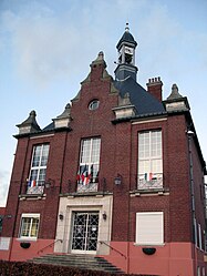
 The town hall in Roisel | |
| Coordinates: 49°56′47″N 3°05′55″E / 49.9464°N 3.0986°E | |
| Country | France |
| Region | Hauts-de-France |
| Department | Somme |
| Arrondissement | Péronne |
| Canton | Péronne |
| Intercommunality | Haute Somme |
| Government | |
| • Mayor (2020–2026) | Jean-Jacques Flament [1] |
| Area 1 | 10.16 km2 (3.92 sq mi) |
| Population (2021)
[2] | 1,592 |
| • Density | 160/km2 (410/sq mi) |
| Time zone | UTC+01:00 ( CET) |
| • Summer ( DST) | UTC+02:00 ( CEST) |
| INSEE/Postal code |
80677 /80240 |
| Elevation | 67–142 m (220–466 ft) (avg. 75 m or 246 ft) |
| 1 French Land Register data, which excludes lakes, ponds, glaciers > 1 km2 (0.386 sq mi or 247 acres) and river estuaries. | |
Roisel (French pronunciation: [ʁwazɛl]) is a commune in the Somme department in Hauts-de-France in northern France.
Roisel is situated 10 miles (16 km) northwest of Saint-Quentin, on the D6 road, with the small river ‘La Cologne’ (a tributary of the Somme) flowing through the commune.
| Year | Pop. | ±% p.a. |
|---|---|---|
| 1968 | 1,908 | — |
| 1975 | 1,846 | −0.47% |
| 1982 | 1,976 | +0.98% |
| 1990 | 1,960 | −0.10% |
| 1999 | 1,929 | −0.18% |
| 2007 | 1,821 | −0.72% |
| 2012 | 1,740 | −0.91% |
| 2017 | 1,613 | −1.50% |
| Source: INSEE [3] | ||
The name of Roisel has an etymology close to that of "roseau" (en: reed) and it's possible, given the ponds, lakes and marches, that the commune takes its name from the landscape. Roisel has strong connections with Saint Fursey.
- St Martin's church. Destroyed during World War I, it was rebuilt by local architect Louis Faille, from Nurlu, soon after 1928
- The town hall (Hotel de ville), rebuilt in 1926 by Maurice Lucet].
- ^ "Répertoire national des élus: les maires". data.gouv.fr, Plateforme ouverte des données publiques françaises (in French). 2 December 2020.
- ^ "Populations légales 2021" (in French). The National Institute of Statistics and Economic Studies. 28 December 2023.
- ^ Population en historique depuis 1968, INSEE
Roisel | |
|---|---|
 The town hall in Roisel | |
| Coordinates: 49°56′47″N 3°05′55″E / 49.9464°N 3.0986°E | |
| Country | France |
| Region | Hauts-de-France |
| Department | Somme |
| Arrondissement | Péronne |
| Canton | Péronne |
| Intercommunality | Haute Somme |
| Government | |
| • Mayor (2020–2026) | Jean-Jacques Flament [1] |
| Area 1 | 10.16 km2 (3.92 sq mi) |
| Population (2021)
[2] | 1,592 |
| • Density | 160/km2 (410/sq mi) |
| Time zone | UTC+01:00 ( CET) |
| • Summer ( DST) | UTC+02:00 ( CEST) |
| INSEE/Postal code |
80677 /80240 |
| Elevation | 67–142 m (220–466 ft) (avg. 75 m or 246 ft) |
| 1 French Land Register data, which excludes lakes, ponds, glaciers > 1 km2 (0.386 sq mi or 247 acres) and river estuaries. | |
Roisel (French pronunciation: [ʁwazɛl]) is a commune in the Somme department in Hauts-de-France in northern France.
Roisel is situated 10 miles (16 km) northwest of Saint-Quentin, on the D6 road, with the small river ‘La Cologne’ (a tributary of the Somme) flowing through the commune.
| Year | Pop. | ±% p.a. |
|---|---|---|
| 1968 | 1,908 | — |
| 1975 | 1,846 | −0.47% |
| 1982 | 1,976 | +0.98% |
| 1990 | 1,960 | −0.10% |
| 1999 | 1,929 | −0.18% |
| 2007 | 1,821 | −0.72% |
| 2012 | 1,740 | −0.91% |
| 2017 | 1,613 | −1.50% |
| Source: INSEE [3] | ||
The name of Roisel has an etymology close to that of "roseau" (en: reed) and it's possible, given the ponds, lakes and marches, that the commune takes its name from the landscape. Roisel has strong connections with Saint Fursey.
- St Martin's church. Destroyed during World War I, it was rebuilt by local architect Louis Faille, from Nurlu, soon after 1928
- The town hall (Hotel de ville), rebuilt in 1926 by Maurice Lucet].
- ^ "Répertoire national des élus: les maires". data.gouv.fr, Plateforme ouverte des données publiques françaises (in French). 2 December 2020.
- ^ "Populations légales 2021" (in French). The National Institute of Statistics and Economic Studies. 28 December 2023.
- ^ Population en historique depuis 1968, INSEE


