Ercheu | |
|---|---|
 Ercheu  Ercheu | |
| Coordinates: 49°42′06″N 2°56′32″E / 49.7017°N 2.9422°E | |
| Country | France |
| Region | Hauts-de-France |
| Department | Somme |
| Arrondissement | Montdidier |
| Canton | Roye |
| Intercommunality | CC Grand Roye |
| Government | |
| • Mayor (2020–2026) | François Lamaire [1] |
| Area 1 | 14.15 km2 (5.46 sq mi) |
| Population (2021)
[2] | 758 |
| • Density | 54/km2 (140/sq mi) |
| Time zone | UTC+01:00 ( CET) |
| • Summer ( DST) | UTC+02:00 ( CEST) |
| INSEE/Postal code |
80279 /80400 |
| Elevation | 58–95 m (190–312 ft) (avg. 70 m or 230 ft) |
| 1 French Land Register data, which excludes lakes, ponds, glaciers > 1 km2 (0.386 sq mi or 247 acres) and river estuaries. | |
Ercheu (French pronunciation: [ɛʁʃø]; Picard: Èrchu ) is a commune in the Somme department in Hauts-de-France in northern France.
Etymology of the place name
Diverting from the Latin word " Arx-Arcis ", strengthened place:
 988 : Arceium
1048 : Archeium
1150 : Erceium
1170 : Erchive
1237 : Herciaus
1248 : Erchieu
1633 : Erchu
1705 : Archeu
1764 : Ercheu
The name of the municipality is unchanged since 1764.
Geography
Ercheu lies on the D15 and D168 junction, and is around 7.5 kilometres (5 mi) south of Nesle and 13 kilometres (8 mi) east of Roye, stretching from the Canal du Nord to the Petit Ingon, which originates in the neighbouring municipality of Libermont, in the Département of Oise. Although peak tunnel "Souterrain de Panneterie" of the Canal du Nord lies outside the neighbouring municipality, it is named after Ferme La Panneterie located in Ercheu.
The castle-like Ferme Lannoy was a monastery named Notre Dame ('Our Lady') in the 14th century.
History
There was once an Merovingian cemetery in Ercheu. Since 1120 there was also a leper colony.
In the First World War, the village was destroyed. The community received the Croix de guerre 1914-1918 as an award.
The former villages Bessancourt, Ramecourt, and Wailly-lès-Ercheu were abandoned.
Population
| Year | Pop. | ±% p.a. |
|---|---|---|
| 1968 | 576 | — |
| 1975 | 601 | +0.61% |
| 1982 | 648 | +1.08% |
| 1990 | 709 | +1.13% |
| 1999 | 704 | −0.08% |
| 2007 | 790 | +1.45% |
| 2012 | 813 | +0.58% |
| 2017 | 785 | −0.70% |
| Source: INSEE [3] | ||
Administration
The current mayor is François Lamaire, in office since 2014 and re-elected in 2020. [1] Ercheu is part of the communauté de communes du Grand Roye since January 1, 2012.
Gallery
-
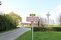 Entrance to Ercheu
 -
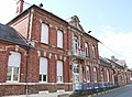 Town Hall
 -
 Panorama of Ercheu
 -
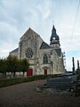 Church
 -
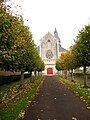 Church, front view


_France_(2).JPG)
_France_(3).JPG)
See also
References
- ^ a b "Répertoire national des élus: les maires". data.gouv.fr, Plateforme ouverte des données publiques françaises (in French). 2 December 2020.
- ^ "Populations légales 2021". The National Institute of Statistics and Economic Studies. 28 December 2023.
- ^ Population en historique depuis 1968, INSEE
External links
- Official website (in French)
| Authority control databases: National |
|---|
Ercheu | |
|---|---|
Ercheu Ercheu | |
| Coordinates: 49°42′06″N 2°56′32″E / 49.7017°N 2.9422°E | |
| Country | France |
| Region | Hauts-de-France |
| Department | Somme |
| Arrondissement | Montdidier |
| Canton | Roye |
| Intercommunality | CC Grand Roye |
| Government | |
| • Mayor (2020–2026) | François Lamaire [1] |
| Area 1 | 14.15 km2 (5.46 sq mi) |
| Population (2021)
[2] | 758 |
| • Density | 54/km2 (140/sq mi) |
| Time zone | UTC+01:00 ( CET) |
| • Summer ( DST) | UTC+02:00 ( CEST) |
| INSEE/Postal code |
80279 /80400 |
| Elevation | 58–95 m (190–312 ft) (avg. 70 m or 230 ft) |
| 1 French Land Register data, which excludes lakes, ponds, glaciers > 1 km2 (0.386 sq mi or 247 acres) and river estuaries. | |
Ercheu (French pronunciation: [ɛʁʃø]; Picard: Èrchu ) is a commune in the Somme department in Hauts-de-France in northern France.
Etymology of the place name
Diverting from the Latin word " Arx-Arcis ", strengthened place:
 988 : Arceium
1048 : Archeium
1150 : Erceium
1170 : Erchive
1237 : Herciaus
1248 : Erchieu
1633 : Erchu
1705 : Archeu
1764 : Ercheu
The name of the municipality is unchanged since 1764.
Geography
Ercheu lies on the D15 and D168 junction, and is around 7.5 kilometres (5 mi) south of Nesle and 13 kilometres (8 mi) east of Roye, stretching from the Canal du Nord to the Petit Ingon, which originates in the neighbouring municipality of Libermont, in the Département of Oise. Although peak tunnel "Souterrain de Panneterie" of the Canal du Nord lies outside the neighbouring municipality, it is named after Ferme La Panneterie located in Ercheu.
The castle-like Ferme Lannoy was a monastery named Notre Dame ('Our Lady') in the 14th century.
History
There was once an Merovingian cemetery in Ercheu. Since 1120 there was also a leper colony.
In the First World War, the village was destroyed. The community received the Croix de guerre 1914-1918 as an award.
The former villages Bessancourt, Ramecourt, and Wailly-lès-Ercheu were abandoned.
Population
| Year | Pop. | ±% p.a. |
|---|---|---|
| 1968 | 576 | — |
| 1975 | 601 | +0.61% |
| 1982 | 648 | +1.08% |
| 1990 | 709 | +1.13% |
| 1999 | 704 | −0.08% |
| 2007 | 790 | +1.45% |
| 2012 | 813 | +0.58% |
| 2017 | 785 | −0.70% |
| Source: INSEE [3] | ||
Administration
The current mayor is François Lamaire, in office since 2014 and re-elected in 2020. [1] Ercheu is part of the communauté de communes du Grand Roye since January 1, 2012.
Gallery
-
Entrance to Ercheu
-
Town Hall
-
Panorama of Ercheu
-
Church
-
Church, front view
See also
References
- ^ a b "Répertoire national des élus: les maires". data.gouv.fr, Plateforme ouverte des données publiques françaises (in French). 2 December 2020.
- ^ "Populations légales 2021". The National Institute of Statistics and Economic Studies. 28 December 2023.
- ^ Population en historique depuis 1968, INSEE
External links
- Official website (in French)
| Authority control databases: National |
|---|