Hauts-de-France
Heuts-d'Franche (
Picard) | |
|---|---|
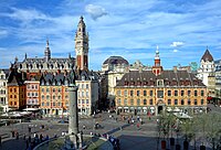
 Grand Place in
Lille | |
 Flag  Coat of arms | |
 | |
| Coordinates: 49°55′14″N 2°42′11″E / 49.9206°N 2.7030°E | |
| Country | |
| Prefecture | Lille |
| Departments | 5
|
| Government | |
| • President of the Regional Council | Xavier Bertrand ( LR) |
| Area | |
| • Total | 31,813 km2 (12,283 sq mi) |
| • Rank | 9th |
| Population (2021)
[1] | |
| • Total | 5,995,292 |
| • Density | 190/km2 (490/sq mi) |
| GDP | |
| • Total | €185.472 billion (2022) |
| • Per capita | €30,900 (2022) |
| Time zone | UTC+01:00 ( CET) |
| • Summer ( DST) | UTC+02:00 ( CEST) |
| ISO 3166 code | FR-HDF |
| NUTS Region | FRE |
| Website |
www |
Hauts-de-France (French pronunciation: [o də fʁɑ̃s] ⓘ; lit. 'Heights of France', also Upper France, [3] Picard: Heuts d'Franche) is the northernmost region of France, created by the territorial reform of French regions in 2014, from a merger of Nord-Pas-de-Calais and Picardy. Its prefecture is Lille. The new region came into existence on 1 January 2016, after regional elections in December 2015. [4] The Conseil d'État approved Hauts-de-France as the name of the region on 28 September 2016, effective the following 30 September. [5] [6]
With 6,009,976 inhabitants as of 1 January 2015 and a population density of 189 inhabitants per km2, it is the third most populous region in France and the second-most densely populated in metropolitan France after its southern neighbour Île-de-France. It is bordered by Belgium to the north. The region is a blend mixture of French and (southern-) Dutch cultures.
Toponymy
The region's interim name Nord-Pas-de-Calais-Picardie was a hyphenated placename, created by hyphenating the merged regions' names— Nord-Pas-de-Calais and Picardie—in alphabetical order. [7]
On 14 March 2016, well ahead of the 1 July deadline, the regional council decided on Hauts-de-France as the region's permanent name. [5] [7] The provisional name of the region was retired on 30 September 2016, when the new name of the region, Hauts-de-France, took effect. [6]
Geography
The region covers an area of more than 31,813 km2 (12,283 sq mi). It borders Belgium ( Flanders and Wallonia) to the northeast, the North Sea to the north, the English Channel to the west, as well as the French regions of Grand Est to the east-southeast, Île-de-France to the south, and Normandy to the west-southwest. It is connected to the United Kingdom ( England) via the Channel Tunnel.

Departments
Hauts-de-France comprises five departments: Aisne, Nord, Oise, Pas-de-Calais, and Somme.
Major communities
- Lille (227,560; region prefecture; surrounding area is home to over 1.5 million inhabitants)
- Amiens (133,448)
- Roubaix (94,713)
- Tourcoing (91,923)
- Dunkirk (90,995)
- Calais (72,589)
- Villeneuve-d'Ascq (62,308)
- Saint-Quentin (55,978)
- Beauvais (54,289)
- Valenciennes (42,691)
-
 Notre Dame de Laon, France
 -
-

-

.JPG)

Economy
The gross domestic product (GDP) of the region was 161.7 billion euros in 2018, accounting for 6.9% of French economic output. GDP per capita adjusted for purchasing power was 24,200 euros or 80% of the EU27 average in the same year. The GDP per employee was 101% of the EU average. [8]
Linen weaving
The region was a pivotal centre of mulquinerie.
See also
- Battle of Vimy Ridge
- Canadian National Vimy Memorial
- Nord-Pas-de-Calais
- Picardy
- Regional Council of the Hauts-de-France
- Regions of France
- Achicourt station
References
- ^ "Téléchargement du fichier d'ensemble des populations légales en 2021". The National Institute of Statistics and Economic Studies. 28 December 2023.
- ^ "EU regions by GDP, Eurostat". Retrieved 18 September 2023.
- ^ "The North: Upper France". francerevisited.com.
- ^ "La carte à 13 régions définitivement adoptée" [The 13-region map finally adopted]. Le Monde (in French). Agence France-Presse. 17 December 2014. Retrieved 13 January 2015.
- ^ a b "La Région a voté et s'appelle désormais Hauts-de-France" [The region has voted and is now called Hauts-de-France]. La Voix du Nord (in French). Lille. 15 March 2016. Retrieved 15 March 2016.
- ^ a b Décret n° 2016-1265 du 28 septembre 2016 portant fixation du nom et du chef-lieu de la région Hauts-de-France (in French)
- ^ a b Loi n° 2015–29 du 16 janvier 2015 relative à la délimitation des régions, aux élections régionales et départementales et modifiant le calendrier électoral (in French)
- ^ "Regional GDP per capita ranged from 30% to 263% of the EU average in 2018". Eurostat.
External links
-
Official website
 (in French)
 - Merger of the regions – France 3 Archived 2015-06-16 at the Wayback Machine
| International | |
|---|---|
| National | |
| Geographic | |
| Other | |
Hauts-de-France
Heuts-d'Franche (
Picard) | |
|---|---|
|
Grand Place in
Lille | |
|
Flag Coat of arms | |
|
| |
| Coordinates: 49°55′14″N 2°42′11″E / 49.9206°N 2.7030°E | |
| Country | |
| Prefecture | Lille |
| Departments | 5
|
| Government | |
| • President of the Regional Council | Xavier Bertrand ( LR) |
| Area | |
| • Total | 31,813 km2 (12,283 sq mi) |
| • Rank | 9th |
| Population (2021)
[1] | |
| • Total | 5,995,292 |
| • Density | 190/km2 (490/sq mi) |
| GDP | |
| • Total | €185.472 billion (2022) |
| • Per capita | €30,900 (2022) |
| Time zone | UTC+01:00 ( CET) |
| • Summer ( DST) | UTC+02:00 ( CEST) |
| ISO 3166 code | FR-HDF |
| NUTS Region | FRE |
| Website |
www |
Hauts-de-France (French pronunciation: [o də fʁɑ̃s] ⓘ; lit. 'Heights of France', also Upper France, [3] Picard: Heuts d'Franche) is the northernmost region of France, created by the territorial reform of French regions in 2014, from a merger of Nord-Pas-de-Calais and Picardy. Its prefecture is Lille. The new region came into existence on 1 January 2016, after regional elections in December 2015. [4] The Conseil d'État approved Hauts-de-France as the name of the region on 28 September 2016, effective the following 30 September. [5] [6]
With 6,009,976 inhabitants as of 1 January 2015 and a population density of 189 inhabitants per km2, it is the third most populous region in France and the second-most densely populated in metropolitan France after its southern neighbour Île-de-France. It is bordered by Belgium to the north. The region is a blend mixture of French and (southern-) Dutch cultures.
Toponymy
The region's interim name Nord-Pas-de-Calais-Picardie was a hyphenated placename, created by hyphenating the merged regions' names— Nord-Pas-de-Calais and Picardie—in alphabetical order. [7]
On 14 March 2016, well ahead of the 1 July deadline, the regional council decided on Hauts-de-France as the region's permanent name. [5] [7] The provisional name of the region was retired on 30 September 2016, when the new name of the region, Hauts-de-France, took effect. [6]
Geography
The region covers an area of more than 31,813 km2 (12,283 sq mi). It borders Belgium ( Flanders and Wallonia) to the northeast, the North Sea to the north, the English Channel to the west, as well as the French regions of Grand Est to the east-southeast, Île-de-France to the south, and Normandy to the west-southwest. It is connected to the United Kingdom ( England) via the Channel Tunnel.
Departments
Hauts-de-France comprises five departments: Aisne, Nord, Oise, Pas-de-Calais, and Somme.
Major communities
- Lille (227,560; region prefecture; surrounding area is home to over 1.5 million inhabitants)
- Amiens (133,448)
- Roubaix (94,713)
- Tourcoing (91,923)
- Dunkirk (90,995)
- Calais (72,589)
- Villeneuve-d'Ascq (62,308)
- Saint-Quentin (55,978)
- Beauvais (54,289)
- Valenciennes (42,691)
-
Notre Dame de Laon, France
-
-
-
Economy
The gross domestic product (GDP) of the region was 161.7 billion euros in 2018, accounting for 6.9% of French economic output. GDP per capita adjusted for purchasing power was 24,200 euros or 80% of the EU27 average in the same year. The GDP per employee was 101% of the EU average. [8]
Linen weaving
The region was a pivotal centre of mulquinerie.
See also
- Battle of Vimy Ridge
- Canadian National Vimy Memorial
- Nord-Pas-de-Calais
- Picardy
- Regional Council of the Hauts-de-France
- Regions of France
- Achicourt station
References
- ^ "Téléchargement du fichier d'ensemble des populations légales en 2021". The National Institute of Statistics and Economic Studies. 28 December 2023.
- ^ "EU regions by GDP, Eurostat". Retrieved 18 September 2023.
- ^ "The North: Upper France". francerevisited.com.
- ^ "La carte à 13 régions définitivement adoptée" [The 13-region map finally adopted]. Le Monde (in French). Agence France-Presse. 17 December 2014. Retrieved 13 January 2015.
- ^ a b "La Région a voté et s'appelle désormais Hauts-de-France" [The region has voted and is now called Hauts-de-France]. La Voix du Nord (in French). Lille. 15 March 2016. Retrieved 15 March 2016.
- ^ a b Décret n° 2016-1265 du 28 septembre 2016 portant fixation du nom et du chef-lieu de la région Hauts-de-France (in French)
- ^ a b Loi n° 2015–29 du 16 janvier 2015 relative à la délimitation des régions, aux élections régionales et départementales et modifiant le calendrier électoral (in French)
- ^ "Regional GDP per capita ranged from 30% to 263% of the EU average in 2018". Eurostat.
External links
-
Official website
(in French)
- Merger of the regions – France 3 Archived 2015-06-16 at the Wayback Machine
| International | |
|---|---|
| National | |
| Geographic | |
| Other | |