Fresnes-Tilloloy | |
|---|---|
 Town hall | |
 Fresnes-Tilloloy  Fresnes-Tilloloy | |
| Coordinates: 49°59′05″N 1°46′05″E / 49.9847°N 1.7681°E | |
| Country | France |
| Region | Hauts-de-France |
| Department | Somme |
| Arrondissement | Amiens |
| Canton | Poix-de-Picardie |
| Intercommunality | CC Somme Sud-Ouest |
| Government | |
| • Mayor (2020–2026) | Ambre Magnier [1] |
| Area 1 | 3.52 km2 (1.36 sq mi) |
| Population (2021)
[2] | 204 |
| • Density | 58/km2 (150/sq mi) |
| Time zone | UTC+01:00 ( CET) |
| • Summer ( DST) | UTC+02:00 ( CEST) |
| INSEE/Postal code |
80354 /80140 |
| Elevation | 89–116 m (292–381 ft) (avg. 115 m or 377 ft) |
| 1 French Land Register data, which excludes lakes, ponds, glaciers > 1 km2 (0.386 sq mi or 247 acres) and river estuaries. | |
Fresnes-Tilloloy (also: Fresne-Tilloloy [3]) is a commune in the Somme département in the Hauts-de-France region of France.
Geography
The commune is situated 10 miles (16 km) southwest of Abbeville on the D25 road
Population
| Year | Pop. | ±% p.a. |
|---|---|---|
| 1968 | 134 | — |
| 1975 | 130 | −0.43% |
| 1982 | 134 | +0.43% |
| 1990 | 130 | −0.38% |
| 1999 | 137 | +0.58% |
| 2007 | 131 | −0.56% |
| 2012 | 188 | +7.49% |
| 2017 | 203 | +1.55% |
| Source: INSEE [4] | ||
History
The name is derived from the French for the
Linden (Limetree)(fr: tilleul) and the
Ash(fr: frêne) and reference to the village (as Fresnum) is mentioned in 1207.
Tilloloy was also noted in 1373 as Thillolay
[5]
Thilloloy and Fresnes were joined as one commune sometime between 1790 and 1794 as the commune of Fresnes-Tilloloy.'
[3]
Traces of Gallo-Roman settlement have been found in the area, and the Roman road (the "chaussée de Brunehaut" is nearby [6]
In 1346, Edward III, spent some time here [7]
The commune was occupied from 17 February to 9 March 1871 by the Germans during the Franco-Prussian War.
.JPG)
Places of interest
- The Mairie which also houses the school.
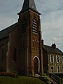
- The medieval church, part demolished and rebuilt in 1860, is dedicated to Saint-Ouen.
-
 Autel de l'Eglise vu de l'entrée
 -


- The cemetery
.JPG)
- The war memorial

See also
References
- ^ "Répertoire national des élus: les maires" (in French). data.gouv.fr, Plateforme ouverte des données publiques françaises. 13 September 2022.
- ^ "Populations légales 2021". The National Institute of Statistics and Economic Studies. 28 December 2023.
- ^ a b Des villages de Cassini aux communes d'aujourd'hui: Commune data sheet Fresnes-Tilloloy, EHESS (in French).
- ^ Population en historique depuis 1968, INSEE
- ^ Autre écriture de Tilloloy, source books.google.com
- ^ Pruvot - "Notice géographique et historique" du 10 juin 1899
- ^ Baie de Somme[ permanent dead link]
External links
- Historique des Régiments de 1914-18 (in French)
| Authority control databases: National |
|---|
Fresnes-Tilloloy | |
|---|---|
|
Town hall | |
Fresnes-Tilloloy Fresnes-Tilloloy | |
| Coordinates: 49°59′05″N 1°46′05″E / 49.9847°N 1.7681°E | |
| Country | France |
| Region | Hauts-de-France |
| Department | Somme |
| Arrondissement | Amiens |
| Canton | Poix-de-Picardie |
| Intercommunality | CC Somme Sud-Ouest |
| Government | |
| • Mayor (2020–2026) | Ambre Magnier [1] |
| Area 1 | 3.52 km2 (1.36 sq mi) |
| Population (2021)
[2] | 204 |
| • Density | 58/km2 (150/sq mi) |
| Time zone | UTC+01:00 ( CET) |
| • Summer ( DST) | UTC+02:00 ( CEST) |
| INSEE/Postal code |
80354 /80140 |
| Elevation | 89–116 m (292–381 ft) (avg. 115 m or 377 ft) |
| 1 French Land Register data, which excludes lakes, ponds, glaciers > 1 km2 (0.386 sq mi or 247 acres) and river estuaries. | |
Fresnes-Tilloloy (also: Fresne-Tilloloy [3]) is a commune in the Somme département in the Hauts-de-France region of France.
Geography
The commune is situated 10 miles (16 km) southwest of Abbeville on the D25 road
Population
| Year | Pop. | ±% p.a. |
|---|---|---|
| 1968 | 134 | — |
| 1975 | 130 | −0.43% |
| 1982 | 134 | +0.43% |
| 1990 | 130 | −0.38% |
| 1999 | 137 | +0.58% |
| 2007 | 131 | −0.56% |
| 2012 | 188 | +7.49% |
| 2017 | 203 | +1.55% |
| Source: INSEE [4] | ||
History
The name is derived from the French for the
Linden (Limetree)(fr: tilleul) and the
Ash(fr: frêne) and reference to the village (as Fresnum) is mentioned in 1207.
Tilloloy was also noted in 1373 as Thillolay
[5]
Thilloloy and Fresnes were joined as one commune sometime between 1790 and 1794 as the commune of Fresnes-Tilloloy.'
[3]
Traces of Gallo-Roman settlement have been found in the area, and the Roman road (the "chaussée de Brunehaut" is nearby [6]
In 1346, Edward III, spent some time here [7]
The commune was occupied from 17 February to 9 March 1871 by the Germans during the Franco-Prussian War.
Places of interest
- The Mairie which also houses the school.
- The medieval church, part demolished and rebuilt in 1860, is dedicated to Saint-Ouen.
-
Autel de l'Eglise vu de l'entrée
-
- The cemetery
- The war memorial
See also
References
- ^ "Répertoire national des élus: les maires" (in French). data.gouv.fr, Plateforme ouverte des données publiques françaises. 13 September 2022.
- ^ "Populations légales 2021". The National Institute of Statistics and Economic Studies. 28 December 2023.
- ^ a b Des villages de Cassini aux communes d'aujourd'hui: Commune data sheet Fresnes-Tilloloy, EHESS (in French).
- ^ Population en historique depuis 1968, INSEE
- ^ Autre écriture de Tilloloy, source books.google.com
- ^ Pruvot - "Notice géographique et historique" du 10 juin 1899
- ^ Baie de Somme[ permanent dead link]
External links
- Historique des Régiments de 1914-18 (in French)
| Authority control databases: National |
|---|