Ailly-sur-Noye
Ailly-dsu-l'Noée (
Picard) | |
|---|---|
 A general view of Ailly-sur-Noye | |
_Somme-France.svg) Coat of arms | |
 Ailly-sur-Noye  Ailly-sur-Noye | |
| Coordinates: 49°45′25″N 2°21′51″E / 49.7569°N 2.3642°E | |
| Country | France |
| Region | Hauts-de-France |
| Department | Somme |
| Arrondissement | Montdidier |
| Canton | Ailly-sur-Noye |
| Intercommunality | Avre Luce Noye |
| Government | |
| • Mayor (2020–2026) | Pierre Durand [1] |
| Area 1 | 25.35 km2 (9.79 sq mi) |
| Population (2021)
[2] | 2,724 |
| • Density | 110/km2 (280/sq mi) |
| Time zone | UTC+01:00 ( CET) |
| • Summer ( DST) | UTC+02:00 ( CEST) |
| INSEE/Postal code |
80010 /80250 |
| Elevation | 43–143 m (141–469 ft) (avg. 57 m or 187 ft) |
| 1 French Land Register data, which excludes lakes, ponds, glaciers > 1 km2 (0.386 sq mi or 247 acres) and river estuaries. | |
Ailly-sur-Noye (French pronunciation: [aji syʁ nwa], literally Ailly on Noye; Picard: Ailly-dsu-l'Noée) is a commune in the Somme department in Hauts-de-France in northern France.

Geography
The commune lies about 20 km (12 mi) south of Amiens and about 13 km (8 mi) from the border with the Oise department, situated at the junction of the departmental roads D7 and the D26, in the valley of the river Noye. Ailly-sur-Noye station has rail connections to Amiens and Creil.
Population
| Year | Pop. | ±% p.a. |
|---|---|---|
| 1968 | 2,008 | — |
| 1975 | 2,134 | +0.87% |
| 1982 | 2,596 | +2.84% |
| 1990 | 2,647 | +0.24% |
| 1999 | 2,643 | −0.02% |
| 2007 | 2,699 | +0.26% |
| 2012 | 2,853 | +1.12% |
| 2017 | 2,838 | −0.11% |
| Source: INSEE [3] | ||
Places and monuments
-
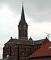 The church, built in 1898
 -
 Town centre (rue St-Martin)
 -
 Town hall


Cultural and sports activities
- Annual Son et Lumière Le Souffle de la terre narrates the story of the people of Picardy from Gaulish times up to the Second World War. More than 450,000 have been to see the spectacle.
- Water sports on the lake area.
- Motocross club on two different courses.
- 45 separate clubs and societies participate in the life of the community.
See also
References
- ^ "Répertoire national des élus: les maires" (in French). data.gouv.fr, Plateforme ouverte des données publiques françaises. 13 September 2022.
- ^ "Populations légales 2021". The National Institute of Statistics and Economic Studies. 28 December 2023.
- ^ Population en historique depuis 1968, INSEE
External links
(All French language)
- The website of the son et lumière ‘Le souffle de la terre’
- Office de Tourisme du Val de Noye
- Ailly sur Noye official site
| International | |
|---|---|
| National | |
Ailly-sur-Noye
Ailly-dsu-l'Noée (
Picard) | |
|---|---|
|
A general view of Ailly-sur-Noye | |
|
Coat of arms | |
Ailly-sur-Noye Ailly-sur-Noye | |
| Coordinates: 49°45′25″N 2°21′51″E / 49.7569°N 2.3642°E | |
| Country | France |
| Region | Hauts-de-France |
| Department | Somme |
| Arrondissement | Montdidier |
| Canton | Ailly-sur-Noye |
| Intercommunality | Avre Luce Noye |
| Government | |
| • Mayor (2020–2026) | Pierre Durand [1] |
| Area 1 | 25.35 km2 (9.79 sq mi) |
| Population (2021)
[2] | 2,724 |
| • Density | 110/km2 (280/sq mi) |
| Time zone | UTC+01:00 ( CET) |
| • Summer ( DST) | UTC+02:00 ( CEST) |
| INSEE/Postal code |
80010 /80250 |
| Elevation | 43–143 m (141–469 ft) (avg. 57 m or 187 ft) |
| 1 French Land Register data, which excludes lakes, ponds, glaciers > 1 km2 (0.386 sq mi or 247 acres) and river estuaries. | |
Ailly-sur-Noye (French pronunciation: [aji syʁ nwa], literally Ailly on Noye; Picard: Ailly-dsu-l'Noée) is a commune in the Somme department in Hauts-de-France in northern France.
Geography
The commune lies about 20 km (12 mi) south of Amiens and about 13 km (8 mi) from the border with the Oise department, situated at the junction of the departmental roads D7 and the D26, in the valley of the river Noye. Ailly-sur-Noye station has rail connections to Amiens and Creil.
Population
| Year | Pop. | ±% p.a. |
|---|---|---|
| 1968 | 2,008 | — |
| 1975 | 2,134 | +0.87% |
| 1982 | 2,596 | +2.84% |
| 1990 | 2,647 | +0.24% |
| 1999 | 2,643 | −0.02% |
| 2007 | 2,699 | +0.26% |
| 2012 | 2,853 | +1.12% |
| 2017 | 2,838 | −0.11% |
| Source: INSEE [3] | ||
Places and monuments
-
The church, built in 1898
-
Town centre (rue St-Martin)
-
Town hall
Cultural and sports activities
- Annual Son et Lumière Le Souffle de la terre narrates the story of the people of Picardy from Gaulish times up to the Second World War. More than 450,000 have been to see the spectacle.
- Water sports on the lake area.
- Motocross club on two different courses.
- 45 separate clubs and societies participate in the life of the community.
See also
References
- ^ "Répertoire national des élus: les maires" (in French). data.gouv.fr, Plateforme ouverte des données publiques françaises. 13 September 2022.
- ^ "Populations légales 2021". The National Institute of Statistics and Economic Studies. 28 December 2023.
- ^ Population en historique depuis 1968, INSEE
External links
(All French language)
- The website of the son et lumière ‘Le souffle de la terre’
- Office de Tourisme du Val de Noye
- Ailly sur Noye official site
| International | |
|---|---|
| National | |