Pavel Leonidovich, did you have an attitude to MIIGAiK's " Red School" in a some time? If "yes" then write to me a message or call me direct, please! B.R.,
Alex Filippov gis_n_map (at) yahoo.com, (cell) —Preceding unsigned comment added by RedSchool ( talk • contribs) 06:35, 21 January 2009 (UTC)
I replied on the talk page for you. Let's work together on this and ensure that the information shown is most accurate. Thank you for your input! Rarelibra 16:39, 29 January 2007 (UTC)
- Hey - I have no source maps available for Mongolia - so if you have one in English that helps in the transliteration, that is an excellent contribution for making the information most accurate and up-to-date! Let me know if you need any assistance...
Rarelibra
14:12, 30 January 2007 (UTC)
- Thank you very much for this effort. There were lots of inaccuracies in the old maps. 132.239.145.119 22:01, 29 June 2007 (UTC)
Bogomolov - my software (MapInfo) does direct translation of Microstation files... so yes, I can view/use DGN format. Rarelibra 13:38, 9 February 2007 (UTC)
Hi, your new maps look nice. I only checked the first two of them so far, and noticed some inconsistencies with Bayan-Ölgii. As a minor point, you spelled Ölgii, Altantsögts, and Delüün without the umlauts. More importantly, my sources indicate that there is also a sum named Tsagannuur, which seems to occupy part of what you currently have as Nogoonnuur and possibly part of Ulaankhus. Any way to confirm this? -- Latebird 10:45, 30 March 2007 (UTC)
- It was great surprise for me- but umlauts was lost... Why? No idea. May be it was first aimag? I will fix umlauts soon. I will add sum population also. What with Цагааннуур? In Авто замын атлас it is shown like major settlement, but not sum centre. Administrative map 2006 does not show Цагааннуур sum. But Цагааннуур is present on sum list http://202.131.5.91/webs/aimags/02/stat_hun_am.htm. But this "sum" looks like "tosgon". Official population table shows: in sum centre (сумын тθв) is 1270 population (хун ам), nomad population is 258 (57 yurts). Aimag centre has more nomads: 680 (147 yurts).Rest of normal sums has 2/3 to 3/4 nomadic population. Note: sums list is in cyrillic alphabetic order, but aimag centre and Цагааннуур are out of order on the table bottom, and Цагааннуур after the city. So, my opinion - Цагааннуур is tosgon with small territory. We are back with tosgons - we have decide how note tosgons on the map. Bogomolov.PL 11:36, 30 March 2007 (UTC)
- In Dornogovi I added sum/sum centre population and notification for tosgon (two tosgons were OFFICIALLY noted in stat table) Bogomolov.PL 15:35, 30 March 2007 (UTC)
I don't think table vertical size is an issue. If we don't use a table, the result will still be long due to the sheer amount of information that needs to be put in. What's more, quite a few featured lists have very long tables, so I believe it is not a problem at all.
It's a pity that foundation dates are not available :( Well, I guess that can be address later; what's not there is not there...
Maps, those also can be addressed after the table is completed. User:Rarelibra has created overview maps for some federal subjects for this project; maybe he'll agree to make an overview map and a set of locator maps for Moscow Oblast as well. Of course, once we have the maps, the tricky part will be to figure out where to place them. I have that same problem with Adygea. If you have ideas, I'll be happy to hear them out.
Using my (future) table will be reasonable to make short district level table. Or it is possible add district statistics into first one? I don't think so. We can always try; that's as good an idea as any. Let's complete the main table first, though.
Of course we have all data to prepare in future every urban/rural settlement lokalities lists (articles?) I was leaning towards putting lists of rural localities into the articles about districts (see Giaginsky District for an example), and only indicating the number of rural localities per rural settlement (or even just the number of rural settlements and the number rural localities they include) in the overview lists such as this one. The benefits of such approach are that the main list is not overloaded with lists of each and every village, and that double-maintenance is avoided (otherwise, every time there is a change, one would need to amend both the main list and the district article). Cities/towns/urban-type settlements, on the other hand, can be listed in both places, as their numbers are a lot more manageable and changes do not occur as often.
In conclusion, before you start putting time into completing the final table, let me ask for an opinion of User:David Kernow, who's been of immense help in the past regarding these types of problems. I'm sure he'll have some valuable feedback for us to consider. Best,— Ëzhiki (Igels Hérissonovich Ïzhakoff-Amursky) • ( yo?); 14:39, 19 April 2007 (UTC)
Hi, I seem to remember a while ago you were looking for a map that shows the borders between Ulaanbaatars duuregs. Ulaanbaatars official website www.ulaanbaatar.mn does contain a map that gives at least a very good idea, but it needs Flash player and is really, really slow. The map is accessible from the main page (if it's in Mongolian, look out for gazrin zurag, at the next screen click on "orox"=enter). Then you'll get a map with some roads and the Tuul and Selbe rivers. On the upper right is a box with features that can be displayed. If don't choose a feature from the list, but the one checkbox above it ("Devsger ongo"), after a while the districts should show.
The website also contains some infos on the different duuregs incl. (some) population numbers, but unfortunately not the dates when the numbers were retrieved. The official statistics seem to unaccessible (except for no. of autobuses, cinemas, head of lifestock and some more). Or at least I always got a message that I understood as "do you tell your secrets to everyone?". Yaan 11:49, 22 May 2007 (UTC)
- It is nice, you remember my appeal. But UB map on www.ulaanbaatar.mn exists since 2006, I know this map. It is several maps on UB landuse office site. But! Problem is not with duureg boundaries in built up territories, but in moutanies which are UB parts (north from UB center). I've analysed all avaliable on-line maps and I have made more or less accurate boundaries on Google Map image for the Greater UB. I've discovered that Baganuur and Bagakhangai are exclaves. I have areas problem: we have very accurate (in ha) areas, I was checking my maps - if area I made is the same - OK, but boundaries for three ajacent duuregs (Чингэлтэй, Баянзурх, Баянгол)are unknown in nothern less pupulated mountain parts and so... I can not complete my job.
- Official statistics are accesible, UB has it's own statistics office in web [1], so I made table in Duureg article in WP.
- If you will find something with sum, khoroo or duureg boundaries, please, inform me. Thank you, Bogomolov.PL 13:22, 22 May 2007 (UTC)

Sorry of that... ;) But then we already have a better (if smaller) version on Commons. -- Latebird 10:26, 13 June 2007 (UTC)
Uhm, because the page is at Zamïn-Üüd, Zamyn-Üüd is (was?) a redlink when I changed them. If it's incorrect feel free to change. AllynJ 15:09, 14 June 2007 (UTC)
moved above comment here from user page
- I just moved that page to Zamyn-Üüd. It had been created with an incorrect title according to WP:MON. -- Latebird 16:50, 14 June 2007 (UTC)
Unfortunately, your "corrected" coordinates for Bayankhongor are not valid, still less located in Mongolia, as they have a latitude of > 90°. You seem to have transposed latitude and longitude: can you check your other similar edits to check that they do not contain any similar mistakes? -- The Anome 16:27, 1 August 2007 (UTC)
- I've now fixed the transposition: however, your coordinates do not match up with those given for Bayankhongor by a number of online map services: would something like 46°41′48″N 100°9′1″E / 46.69667°N 100.15028°E possibly be better? -- The Anome 16:48, 1 August 2007 (UTC)
I've corrected Bayankhongor coordinates because NO online cities lists have correct data for this city. With lat/lon - it is my mistake, thanks. Happens. For coordinates data correction I'm using Google Earth, where I'm looking for city IMAGE (not red spot from vector levels). You can check Erdenetsogt - it has 10 miles shift from its real location to SE. ALL Mongolian cities locations need to be corrected. If I will find any time, I will do that. And it is an other one problem - from online databases to WP were loaded cities with wrong names (not locations only) and settlements which dissolved decades ago. I mean Tüyin-goliin hid (you can find it in GE close to Erdenetsogt) or Jargalan (close to the real Bayankhongor location). I was in the expedition to the East Kazakhstan, so my answer delay...
Thank you for your attention. Bogomolov.PL 08:19, 27 August 2007 (UTC)
The two have somewhat different meanings. "Subdivision" is the act of subdividing, both as a concrete action or as a more abstract process. "Subdivisions" are the units that result from the act of subdivision, that is, they are the units into which the aimag is subdivided.
From a couple of online dictionaries:
1. the act or fact of subdividing. 2. a product of subdividing, as a section of a department. 3. a portion of land divided into lots for real-estate development. 4. Botany, Mycology. a category of related classes within a division or phylum.
n. 1. a. The act or process of subdividing. b. A subdivided part. 2. An area of real estate composed of subdivided lots.
In this case, 'subdivisions' seems better, because Sums are administrative subdivisions of the aimag. 'Subdivision' is not impossible, in the sense of "the way the aimag is administratively subdivided", but frankly it sounds awkward. I would recommend "Subdivisions".
Yes, I'm in Ulaanbaatar now. I don't know enough about Mongolia to contribute very much. I have got involved in a rather protracted wrangle at China!
Bathrobe 12:27, 24 September 2007 (UTC)
Thank you for your work on correcting geodata values. It's very much appreciated. -- The Anome 12:53, 24 September 2007 (UTC)
Hi!
A while ago, you asked me about creating a Khotgoid article. Sounds like a good idea, but I'm a bit lazy now. If you'd like to create an article, please do. Re. etymology, my sources (that Hövsgöl aimgiin lavlah tol and another similar book from 1991) say that the name might also be related to sheep (the first one: derived from khot khonitoi, the other one: derived from the Oirat word koi or khoi = sheep).
I also got across another source on Khatgals administrative status. According to that source (some management plan for the Khövsgöl National Park), Khatgal is a somewhat autonomous part of Alag-Erdene sum, not independent from it. The english translation of the plan stated that the local Khural had 20 members, eight from Khatgal and twelve from Alag-Erdene, but that Khatgal has its own budget. I already changed it in the Khatgal and Khövsgöl articles and in the template. If you don't like it, just undo.
Last, not least: Do you have any info on the status of the Mongolian Power grid? They seem to be making real progress in Khövsgöl, with Alag-Erdene and Khatgal having been connected this year and Tömörbulag, Arbulag and Bayanzürkh apparently in the pipeline (Bürentogtokh and most of the southeastern and, apparently, southern sums are already connected). Of course this may be related to ministers Enkhtuvshin and esp. Erdenebat plus former minister Gundalai having their constuencies in the area, so it would be interesting to know what the situation is like in other areas.
Regards, Yaan 10:45, 2 October 2007 (UTC)
- Your opinion that Khatgal is sovereign tosgon was important, but not single. As you know, Khatgal is separate in the Annual Livestock Census 2004 (it seems to be more official name, isn't it?), it is separate in sum list for country electoral division [2], it has own sum level code in SALB project of UN [3]. I know that was law from 1 April 1994 about legal status of cities and tosgons, but I don't know its text (in readable language). The fact that Khatgal tosgon has no own khural is clear - this ИТХ is not presented at ИТХ list [4]. Does Khatgal have own тосгон дарга? I was couple times in tosgon Bayantooroi (in Govi-Altai, it was before WP), but building with banner was, post office also. So I was sure this settlement was normal sum. So we need make a decision - is tosgon administrative 2-d level division or statistical phenomenon. Just now only 1 (one) tosgon ( Tsagaannuur, Bayan-Ölgii) separate from sum exists, the rest of the tosgons are sum parts. Mb the law text can help in this decision?
- Khotgoid. Half a loaf is better than no bread, but my English... I think you have some informations to create this article. It is possible that its wikification would stimulate WP society to improve it.
- Power lines. I was watching for power network informations [5] and so on. As a cartographer I see a future grid map, updated every 4-6 months. Bogomolov.PL 14:31, 2 October 2007 (UTC)
Nice - I log on this morning and check to see that I have a full critique of my map. Next time at least say hello first. Rarelibra 12:43, 5 October 2007 (UTC)
- It is not any critique, this map is huge work (I know!). I wanted help you, not more... It was not any letter, but information. Every map has mistakes, masters eye doesn't see a lot of things. I spent an hour and checked your map. You posted map, so you are prepared, that everybody (even me) will want help you. Hello! Bogomolov.PL 12:57, 5 October 2007 (UTC)
Your map has white holes in Achaea and Attica.
Achaea was a coding mistake in my query, with Attica - you probably missed the image summary of "The map is incomplete due to the unavailable data for East Attica prefecture. This will be resolved soon."
- This summary notification was for high resolution image, not low resolution I’ve analyzed. You think I had time? High res posted 23:33, low res replaced it 23:34. But next time I will study image history.
Symi island needs to be divided in two (Nimos island is separate). Sesklio needs to be added.
Research generalization - specifially, read more about simplification. Depending on the scale, an item may or may not be denoted to a level of detail, complexity, or delineation - it all solely depends on the source data. You also forgot to mention Marmaras Island. And Khodros Island as well. :)
- Generalization. You are a cartographer, you know what is it. It is used, for example, when your source map has large scale, but result – small scale. You need to have qualification size: the size (for example) of island when it is not shown on a map. On your map are islands 4 and 5 pixels size (even 1 island Pelouzo is 3 pixels size, Google Earth shows its dimensions: 650 m long and 250 m wide [6]). One pixel on your map was about 0.478 km (0.22 sq.km). Pixel size is most deciding for digital raster map, isn’t it? So YOU decided that 4 pixels size islands are visible on your map. 1 sq.km, isn’t it?
- I use the software, not the pixels. This is a hobby, my friend. I'm not trying to win a dissertation.
- You create pixels and raster map we are talking about. I'm sure you have your logic in your map creating process. This logic decides when you are or not digitizing the concrete island. So you were putting on your map 1 sq.km size islands, it is fact. This size of islands is possible to show on the map and you did this.
- Large number of trees is creating a forest, large number of mountains is creating a range. Large number of islands is NOT creating a continent. When on the map two islands are shown as single – it is not reasonable. Usually it is used enhancement to show a strait presence.
- It is very reasonable. I won't take the time, but could show you many data sets that are like this, due to simplification. I don't have that kind of time, and I am sure that you should understand this concept of generalization in the first place.
- You reduces generalization to simplification only. Any selection, enhancement... Research generalization. If somebody makes maps the same way - yes, I know such maps with pixel dust. But on your map is no pixel dust. It is no (sorry, only 1) objects less than 4 pixels size. So your map was created with (spontaneous may be) filtering of very small islands. You really think you can make a continent from a number of islands? Will be this map objective?
Kastelorizo, Stroggyli Kastellorizou, Rho Island have to be added.
Kasterlorizo is quite small - in fact, Microsoft's software shows it connected to the Turkish mainland. Really - the island is 10 km². And Stroggyli Kastellorizou - even more so at 0.9 km² (both Microsoft and Google have apparently forgotten to show this important island with one building on it). Rho Island is definitely an oversight - so thank you for catching that.
- You are administrative subdivisions map creator, so you have know the country limits. Kastelorizo etc. are extremely Eastern (Asian!) part of Greece. Even if Microsoft's software shows it connected to the Turkish mainland (Microsoft Live Search adds this islands to Greece: [7]). With Google, you are in a mistake too: [8]. All mentioned islands are, and they are Greek.
- Every island with area over 1 sq.km. has to be shown – YOU have on your map islands with the same and smaller size. 10 sq.km is TEN times more than qualification size.
- If you don't show the island on your map it can be interpreted this island is Turkish. I don't like this.
- Nothing has to be shown at all. I could represent Greece on a map with one big polygon and no islands. That is the artistic nature of mapping. By nitpicking shape and size you display another trait. I'm sorry, but you are in the wrong in assuming that someone creating something in an artistic nature must abide by - your rules. When YOU make the map, YOU can abide by YOUR rules. Simply put. But do not try to push the expectation that someone creating something of this nature must (or in your words, has) to be shown.
- Will be a big poligon objective? Will be useful? Why you didn't make such a poligon instead of normal map you made? You was not artistic? You were objective, and so you are reflecting on your map the objective Greece geography. You want say you respect no rules? No, I think. If you are logic and objective (I think so, you are), you need have special reasons to ignore this parts of Greece national territory. Say me - is it logic to show on your map an island which is TEN times bigger then already shown? I can not beleave you are not logic. You are.
- National borders is very delicate theme, and you and me must be very objective. If an island is not shown on the map it CAN be interpreted it is OUT of the national border. I don't like this, I hope you too. May be it is not the rule which you don't respect?
Kalolimnos island has to be added.
The reference map I used did not have this island on it - but I have verified it via Google and Microsoft. You forgot to mention Nera, Pita, Imia, and Zouka - but I added those as well. (Pita, Imia, and Zouka somehow didn't make it on the Google and Microsoft maps either).
- I wanted pay your attention on the region of Kalolimnos, so I’m glad you’ve fixed more VERY VERY small islands, but creating Greek border
- I added those as a luxury, for pete's sake.
Leipsoi on your map is in two parts, but it is single island.
This came from the low-res set. I put added the bridge in there. But again, research Simplification - as this can happen with low res sets.
- Topology question. Do we need topology true or not? You agree that a “bridge” is nessesary, OK.
- I put the bridge in there - I said nothing about necessity.
- If bridge was not nessesary, why you made them? I think you are objective, so you made it.
Oinousses island has East neighbour (Greec also), you need add it.
Sure thing - didn't want Oinousses to be lonely. ;)
- Passas island is 3 km long, over 1 km wide, so it is over qualification size. I didn’t say about Vatos island (it can be less than qualification size). And both are creating Greek border.
- In your RESPONSE you omitted my sentence: “Islands listed above are creating Greek border”. So you agree with special importance of these islands… You added even very small islands along the border – so you agree in act.
- I don't 'agree' to anything in act. Please do not attempt to label or push something onto my actions. If you evaluated the Canadian coast in some maps, I'm sure many small islands would be left out. I'm sure there are small islands in the fjords of Norway that are left out. And I am quite sure that several of the THOUSANDS of islands in Papua New Guinea do not exist on some maps. Generalization, simplification - it gives a cartographer the right to choose for context, scale, and focus.
- You disagree in act? You disagree with special importance of the national border? I don't think so. I hope you will never change border shape to show your disagreement. You are objective in act. Does your Greek friend will agree with Kastelorizo, Stroggyli Kastellorizou, Rho absence on Greece map?
1. Ammouliani isles (near Halkidiki).
My oversight.
- Happens…
2. Psathoura.
Yeah. But you also forgot to mention Skantili, Korakas, and Adelfopoulo.
- Excuse me, but YOU forgot Skantili, Korakas, and Adelfopoulo on YOUR map. And I’m not sure these islands are over qualification size…
- No, YOU forgot to find them in your evaluation. And all this that you keep mentioning "qualification size". Sorry - but there isn't a 'qualification size' rule when it comes to making maps. Again - if there were 5 small islands and you draw a polygon around them, that qualifies for the map being drawn. In your eyes, it would not be as accurate, however, again - this is for the topic of the cartographer, not the critic.
- I spent 1 hour in my evaluation. You say your map has more lost islands. Sorry, you lost the islands, not me. I never clame I've found all losses. You clame your map has much more losses, I think so too.
- Why you didn't put on your map islands less then 1 sq.km? Was no reasons? This no reasons is qualification size rule in act.
- And I don't criticize you or your map: every map has mistakes. I want help you make this map better.
3. Kythnos.
This was a query error.
- OK
4. Gios Georgios.
Do you mean Agios Georgios in Corfu? There is no such thing as "Gios Georgios."
- In Google Earth 37:28:53N 23:55:28E (Gios Georgios). In Google Map (Agios Georgios) [9], 40 km W from Kythnos.
- It is good idea to use Google Earth/Map, I think.
5. Islands along Attika South coast.
Can't believe I missed such unnamed islands! :)
- These islands have names (from NW to SE): Fleves, Arsida and Patroklou. You can find their names in Google Earth and Google Map.
- It is good idea to use Google Earth/Map, I think.
- I was being facetious.
6. Christiana Island.
A tiny, rocky speck of an island used for bird-watching. Wow, can't believe I missed it. ;)
- You missed it, it is over qualification size, and it is an article in WP.
- Again, whether or not an article exists doesn't matter - nor is there any defined qualification size.
7. Pachia and Makra.
The reference map I used did not have these smaller islands on it - but I have verified them via Google and Microsoft.
- OK, their are over qualification size, and it is an article in WP
- Qualification - blah, blah. See above.
8. Zafora, Chamili, Astakida etc.
The reference map I used did not have these smaller islands on it - but I have verified them via Google and Microsoft.
- OK.
9. Kandelioussa, Pergausa, Pacheia.
The reference map I used did not have these smaller islands on it - but I have verified them via Google and Microsoft.
- OK.
10.Archagellos (north from Leros).
A smaller island, again - possibly trivial, since there were even smaller islands missed (including Patelidi, Tripiti, Strogilli, Agia Kyriaki, Mikro Glaronissi, and Megalo Glaronissi).
- Archagellos is 2.5 km long, 1 km wide. It is normal when islands smaller than qualification size are omitted (if they are not creating national border).
- Qualification - blah, blah. See above.
Methana is a peninsula.
This is another detail/scale/resolution thing, but ok. Added.
- OK. Topology is important.
Kythira and Antikythera shapes are wrong.
Noted. I have corrected their shapes.
- OK.
Limni Vouliagmeni is lake, not Korinthos Bay part.
After locating this, I can understand your concern (though I feel is very, very detailed in nature).
- You choose scale, so you choose detail level.
- Here you actually acknowledge that I chose the scale and detail - this is confusing.
- Why it was confusing for you? The smallest island size (for example) was calculated from your map image scale and detail level.
Greec - Turkish border is too straight (Evros river is not so straight).
The reference layer I use is low-resolution. There are times that I come across high(er) resolution data sets, and I try to incorporate those into my own set. But when using reference maps, I am limited to the reference detail and resolution. You should know this, as a fellow cartographer.
- Every time we have Google Map, Virtual Earth, Yahoo! Maps etc. In many cases these online sources are detailed.
Near Ioannina is a black spot.
Software error - corrected.
- OK.
Near Kremasta (lake) is a black spot.
Software error - corrected.
- OK.
Just so you know, the references I used were from a friend of mine who does a lot of mapping on Greek Wiki (and lives there). I used his reference maps. Not all maps are the same, nor are they perfect. I didn't expect a full-out critique to the level of detail that you included. Don't get me wrong - I appreciate you spending an hour (!!!). But I spent many hours researching and adding such. Remember - this is my hobby.
- I spent vacations in Greece this May, so I have free map (1: 1M) from reception. And I have Google Earth/Map also. To check maps is much easier than correct them, I know. So I made an easiest part of job. What I made was a corrections list, you made ALL these corrections. And it was no emotions from my side, isn’t it?
- Not emotion - but in your professional approach you may be missing the underlying tone.
- You several times mentioned I don't know generalization rule (only one from rules set), I never questioned your qualification. But in your professional approach you may be missing the underlying tone.
I tried not to take your critique to heart, but some of the mentioned items seem quite trivial for the detail of the map. To mention an island left out (a larger one, that is) is one thing, to criticize the border between two countries is without merit, especially with the scope, resolution, and detail of the actual project and/or map. Keep that in mind.
- Greek national border is very important, every (even small) island creating this border has be very accurate, so I was specially interested in this point. You lost a number of islands along the national border, I’ve found these losses, you fixed them. I was not criticized anybody, I didn’t like not completely accurate border. And you agreed with ALL my remarks, and fixed even more. Be accurate with national borders, keep that in mind. Bogomolov.PL 14:31, 8 October 2007 (UTC)
What I took to heart is you looked at something and - several times - shot a critique for islands that are quite small in comparison to the map scale. The bird island - article in Wiki or not - is small and non defining of the border. If I was submitting a map for dissertation, I'm quite certain my sources would be quite detailed and the map would take months to create. But this is a hobby, and the sources I used - Greek sources - in some cases, did not have the smaller islands on there (thus, it was a luxury for me to go back and reference them in). Your criticism is unwelcomed. If you created a map of the US, for example, as a straight line along Mexico - the first thing I would do would not be to complain about the level of detail and the meandering Rio Grande. I would, instead, look at the context of the map. This isn't a National Geographic project we are talking about here, it is a reference map for a Wikipedia article. Some of my sources have high-res data sets, some do not.
I would hate to do a map of Papua New Guinea and have the same level of critique ;) Rarelibra 18:32, 5 October 2007 (UTC)
- I don't like the scale of new map - Athens/Pireas vicinity is not readable. Can you make the scale larger? Bogomolov.PL 14:39, 8 October 2007 (UTC)
- In this case, I choose the scale and my answer is no. That map is designed to be an overall reference - more detailed maps exist in Greek wiki (and are available on Commons), if that is what you need. Rarelibra 15:17, 8 October 2007 (UTC)
Just one more quick note - there once was a user a while ago who attempted to label me as a 'racist' because, in his eyes, he felt that I was purposely making the text on African maps smaller. It was quite shocking, actually, to hear this and offended me greatly. I was surprised at the small-mindedness that such an individual could use in throwing around such a strong accusation based off of something so objective as a map. That is like that people who try to sue Rand McNally because their map shows a road continuing through an area where a truck driver, looking at the map, drove off the road into a culvert - ignoring the big "ROAD CONSTRUCTION" signs.
While I don't take the same offense here - viewing some helpful corrections from you - it does become borderline offensive to talk about 'qualification sizing' and rationalizing 'acts' in order to point things out. There really is nothing qualifying in making a map - there are concepts of generalization, etc that help guide the cartographer into general rules of putting something together. Critics are never welcome, and objectivity is always in the eye of the viewer. Sometimes someone will complain that a map needs, say, a scale or north arrow. While legitimate, there are times when a map can be made without such and still provide reference and utility to the user.
So again - if I make a map of a lower scale/higher resolution area - you will see more detail. But be careful of such in the context of the map. Rarelibra 15:28, 8 October 2007 (UTC)
The map is something very objective, yes. But map is made by the subjects, yes.
Map usually has the same projection at all its parts, the same signs system, same accuracy, same scale (respecting projection limitations). Is it very natural? For me is very natural.
Qualification size. I’m not sure with this term, but I hope you are understanding what I mean. It is size of geography object (river length, city population etc.) which helps formally define this object presence on the map of concrete scale and/or concrete category. Example: on a soil map we will show only provincial cities only, but on a population map with the same scale – all the cities, but no soils.
Concrete qualification sizes values are defined for topo maps and several nautical, geology maps etc. For them are instructions and everybody has respect them, if no – it will be not topo, nautical or geology map, but something else.
If somebody is creating map not mentioned above, this map author can make own rules for map creating.
I was trying to analyze your conception of the map. For me was very natural to find the rules you used. First of all I wanted find the island size limitations – what size is shown at your map. I’ve found, that the smallest islands were 4 pixels size, I’ve calculated, that it is approx. 1 sq.km. You see I didn’t add to the corrections list islands with the size less than 1 sq.km. I hoped you had (may be spontaneous) filter – “I will not digitize this island, it is too small”. I’ve created the qualification size for me, because in my small job I was using detailed maps and I need to make the same decisions to put island on the list or not.
Using qualification size filter is normal for automatic generalization, isn’t it? It looks like you’ve used it – only 1 (one) island on your map was less than qualification size value. It was not any surprise for me, it was very natural in my opinion. Bogomolov.PL 16:56, 8 October 2007 (UTC)
Your map latest version has not existing in reality island NE from Rhodes (NW from Megisti=Kastelorizo). It is a Turkish peninsula, not Greek island. Hello!
- Hello again. I have corrected this - so thanks for pointing that out. But that is it, my friend. No more granular evaluation of a map that is not to the scale of detail to show all of the islands, or shapes of peninsulas or outcroppings, or < 1km islands, etc. This is a hobby and I cannot spend so much time trying to appease the amount of detail required in such a critique. If it were going to be a wall map the size of ANSI E that would be another matter. This is a reference map in wiki. I hope you understand.
- On a side note, I expect you to conduct this kind of evaluation on all other Greek maps, seeing that it is important to you. Especially the maps that I used for reference (located on Greek Wiki and Commons)... seeing how even those maps (made by a Greek) are missing islands and such. Thanks. Rarelibra 16:45, 10 October 2007 (UTC)
I am border sensitive, yes. You are a cartographer too and that is why I am sure you are understanding me. My presence in Wiki is not any profession, you see. You understand - to erase something is the esiest process... You made a large work in adding islands and other corrections, your map is better now, thank you. Bogomolov.PL 16:55, 10 October 2007 (UTC)
Wow - can't believe I didn't catch that, but yes - it was a Colombian map source. Thank you for finding this! I will correct this by tomorrow. Rarelibra 23:57, 23 October 2007 (UTC)
- Corrected version is in place now. Rarelibra 18:59, 24 October 2007 (UTC)
Good point - will ensure the colors align. I'm not too concerned with coterminous areas - the colors are assigned by random selection in the software query. The numbers point out the different areas. As far as the 2004 census data, I don't remember reverting anything - thus, I don't know why you would make such a statement. I don't do statistics anywhere (don't really care), just the maps. I do know that the table needed to be updated because it didn't list the name of one of the governorates (Amanat Al Asimah), and the map wasn't showing two of the governorates (Amanat Al Asimah and Raymah). The reference I have is directly from the Ministry web site of Yemen. -- Rarelibra ( talk) 18:31, 16 November 2007 (UTC)
- I was talking about this [10] your edit. You said: "As far as the 2004 census data, I don't remember reverting anything - thus, I don't know why you would make such a statement. I don't do statistics anywhere (don't really care), just the maps." But Wikipedia shows that you (or somebody logged with your name) reverted my editions. You say you don't remember... I am sure you have remember this, you posted at this edit session your Yemen map, isn't it?.
- And my question again: WHY YOU REVERTED MY EDITIONS?
- And an other question: WHY YOU CLAME YOU DIDN'T DO THAT?
I know exactly what happened. I updated the table on the main Yemen page at 2007-11-16T09:52:59 and then I preceded to copy that update to the Governorates of Yemen page at 2007-11-16T09:54:48. I didn't INTENTIONALLY mean to revert your edits. However, in the line of my defense - you have been INCONSISTENT with your edits, being that you updated the information for the table on the Governorates of Yemen page but you failed to carry those updates forward to the same table on the regular Yemen page under the 'Governorates and districts' section. So in the midst of my updating, it ended up carrying the information from the main article to the governorates article, which subsequently changed the 2004 information you mention. All you needed to do is to investigate as I did to find this - there was no need to not assume good faith and to get angry and make accusations in BOLD above. I appreciate your feedback at times, but this is too much, and I expect you to see that it was UNINTENTIONAL because of the two tables. Rarelibra ( talk) 14:06, 19 November 2007 (UTC)
- I was trying to understand is it edits war, or you have better statistics. Because it was you reverting my edits I felt the need to clear the question. So I stopped editing of the statistics tables until everything will be clear, now I am sure I can update Yemen page too. You can notice I'm making the same kind of editions in Mongolian aimags subdivisions tables. Bogomolov.PL ( talk) 14:35, 19 November 2007 (UTC)
Hi Bogomolov, I updated the East-Hem 1200ad.jpg map, as per your suggestions. Thank you very much for those. You may still see some differences, which I explain on the talk page for the image. I haven't been able to devote much time to figuring out how to combine the maps as you described, but hopefully I'll get some time to do that this week. Thank you again for your help (it is now noted on the image's description page), and if you feel like doing the same with any of the other maps, please do! Respectfully, Thomas Lessman 17:24, 3 December 2007 (UTC)
Nice find - and easy fix. I moved the page to Communes of Burkina Faso, relabeled the template, and the images within the article. Also added the reference you provided from the official Census report. The page was created based off of the information from Statoids (2004/2005) but seems it wasn't as accurate as the information you found. Rarelibra ( talk) 16:18, 14 December 2007 (UTC)
Thanks for the great map of Moscow Oblast! You wouldn't happen to have it in svg by any chance?— Ëzhiki (Igels Hérissonovich Ïzhakoff-Amursky) • ( yo?); 15:29, 26 December 2007 (UTC)
- It is my dream... But my CorelDraw makes SVG not accurate (minified image had enlarged line widths), but today when I look at my test image (Adminisrative divisions of Mongolia)

SVG test

I see everything ok. The FireFox problems were resolved? I can try again with Moscow Oblast now. Bogomolov.PL ( talk) 17:19, 26 December 2007 (UTC)
- I'm sorry, I don't recall—could you remind me what Firefox problem you are talking about?
- My dream is to have svg district-level maps of all Russian federal subjects; preferrably uncolored. This way people would have a template to work with, which they would be able to color/number/add names in any manner they wish. Meanwhile, Moscow Oblast's is a great map to start working with (even if it's going to stay as png only). Thanks again!— Ëzhiki (Igels Hérissonovich Ïzhakoff-Amursky) • ( yo?); 17:41, 26 December 2007 (UTC)
- In my viewer my SVG was (when minified) black - all boundaries were wery wide and covered space of map. That was a problem. Now the same image does not produce this effect and so I hope I will do that SVG colored and outlined.
Bogomolov.PL (
talk)
17:49, 26 December 2007 (UTC)
- Thanks for looking into this! If all goes well, I'll be looking forward to a shiny new svg image :)— Ëzhiki (Igels Hérissonovich Ïzhakoff-Amursky) • ( yo?); 17:53, 26 December 2007 (UTC)
- In my viewer my SVG was (when minified) black - all boundaries were wery wide and covered space of map. That was a problem. Now the same image does not produce this effect and so I hope I will do that SVG colored and outlined.
Bogomolov.PL (
talk)
17:49, 26 December 2007 (UTC)
- Wonderful! Thanks again.— Ëzhiki (Igels Hérissonovich Ïzhakoff-Amursky) • ( yo?); 18:16, 26 December 2007 (UTC)

- Aren't you on a roll today, eh? :) At the risk of sounding like a person who can never be satisfied, would it be terribly difficult to create a parallel map of administrative divisions? It would come in handy when I re-write administrative divisions of Moscow Oblast in the image of administrative and municipal divisions of Adygea. Let me know if you need the list of changes that would need to be made.— Ëzhiki (Igels Hérissonovich Ïzhakoff-Amursky) • ( yo?); 18:23, 26 December 2007 (UTC)
To my idea it can be this way:
- we distinct administrative (rayons and independent cities) and territorial units (rest of the cities and urban/rural settlements).
- So outlined map would be the same, I see.
- The colored map would be painted in less colored regions - a lot of urban okrugs would be merged to the surrounding rayons.
What you see? Bogomolov.PL ( talk) 18:31, 26 December 2007 (UTC)
- What I am looking for in the map of the administrative divisions is first and foremost the outlines of the 38 administrative districts and of the 27 cities under the oblast's jurisdiction. It would be nice to have districts' administrative centers and towns under the districts' jurisdiction, and beyond that, it'd be great to show all of the urban-type settlements. Note, however, that the svg map would not be identical to the svg map of municipal divisions, because the territories of the urban settlements (городские поселения) are larger than the territories of the towns and urban-type settlements around which they are formed (e.g., Dmitrov urban settlement includes not only the town of Dmitrov, but 83 rural localities as well, none of which are a part of Dmitrov proper). Is this something you'd be able to do? I believe showing the urban-type settlements as dots would be sufficient for the administrative map, but if you can do outlines, it'd be simply marvelous.— Ëzhiki (Igels Hérissonovich Ïzhakoff-Amursky) • ( yo?); 18:57, 26 December 2007 (UTC)
- As I know Котельники, Черноголовка, Электрогорск and Лосино-Петровский have independent municipalities but are under administrative rayon jurisdiction. It would be first difference. Is set of 84 villages (dmitrov) the territorial unit?
Bogomolov.PL (
talk)
19:08, 26 December 2007 (UTC)
- These 83 (not 84) villages are a part of a total of 396 territorial units under administrative jurisdiction of Dmitrovsky District. Municipally, however, these 83 are a part of Dmitrov urban settlement. As far as I remember, in Moscow Oblast this is the case for all urban settlements which have rural localities (villages) under their jurisdictions—municipally, those rural localities are under jurisdiction of the urban settlement, but administratively they are under jurisdiction of the (administrative) district. Same goes for the rural settlements. Does this help?— Ëzhiki (Igels Hérissonovich Ïzhakoff-Amursky) • ( yo?); 19:33, 26 December 2007 (UTC)
Several months ago (see Talk:Administrative divisions of Moscow Oblast) I've pointed your attention on [11] where on p.1 is written "территориальные единицы Московской области - сельские поселения", so rural settlements (not localities) are territorial units. Here are corrections to the administrative-territorial division law [12], I can cite:words "rural okrugs, as well urban localities (cities, work and dacha settlements) replace with word "territorial units". Stop. If we will subtract rural settlements - what would we get? Urban settlements territories, isn't it? From spacial point of view it is clear (we are talking about future map, I guess). And we have now in Dmitrovsky rayon 6 rural settlements and 5 urban, not 400 as you think. And what will be difference to the municipality map? Only the merging of several cities (I listed above) to the rayons. Bogomolov.PL ( talk) 06:49, 27 December 2007 (UTC)
- You can't "subtract" rural settlements, because this was not the purpose of the amendment you quoted. Here are two quotes from the same law on administrative and territorial structure of Moscow Oblast:
- Территориальная единица - населенный пункт - часть территории, имеющая сосредоточенную застройку в пределах фиксированной границы и служащая постоянным или преимущественным местом проживания и жизнедеятельности людей, либо группа населенных пунктов, не являющихся в соответствии с настоящим Законом административно-территориальной единицей (город районного подчинения, поселок городского типа (рабочий или дачный), сельский населенный пункт). (emphasis mine)
- Сельское поселение - территориальная единица, состоящая из нескольких объединенных общей территорией сельских населенных пунктов, границы которой совпадают с границами муниципального образования, наделенного статусом сельского поселения.
- Based on these definitions, both rural settlements and rural localities are considered to be territorial units, hence both are included into districts' compositions. Also note that urban settlements (городские поселения) are not mentioned by this law at all, hence they cannot be territorial units. On the urban side, only the cities/towns/urban-type settlements are territorial units (according to the definition above), and a territory of any given town/urban-type settlement is (more often than not) less than the territory of the (municipal) urban settlement formed around it. What this means is that locations of the actual cities/towns/urban-type settlements must be shown on the administrative map. Now, since the territories of (municipal) urban settlements usually correspond to the total of the territories under administrative jurisdiction of those cities/towns/urban-type settlements, it may be useful to show them on the administrative map as well, but only along with the locations of the urban inhabited localities themselves.
- I hope I did not confuse you to death with all this. I just want to help you make a perfect administrative map :) Cheers,— Ëzhiki (Igels Hérissonovich Ïzhakoff-Amursky) • ( yo?); 16:39, 27 December 2007 (UTC)
Your interpretation is: every rural locality has to be territorial unit. The law text you citing tells us that territorial unit is possible be:
- populated locality (city, work/dacha settlement, rural locality) personally (for settlements in practice it can be, but not realised)
- group of populated localities (not AT level units)
Future law text tells us [13]:
16) территориальная единица — это часть территории Московской области — населенный пункт (город районного подчинения, рабочий или дачный поселок городского типа, сельский населенный пункт) либо группа населенных пунктов, не являющихся в соответствии с настоящим Законом административно-территориальной единицей (сельское поселение, территория для развития города или поселка городского типа);
So is possible individual TU:
- city
- work settlement
- dacha settlement
- rural locality (possible, law does not close the doors)
OR are possible "collective" units:
- rural settlement (municipal poin of view)
- territory for city development
- territory for urban-type settlement development
You can find in this text, that territory for development means rural localities territory over municipal rule of the city or urban-type settlement. That was the idea of the new law.
Bogomolov.PL ( talk) 18:31, 27 December 2007 (UTC)
- Thanks for the link to the text of the proposed draft; I have not yet seen it. However, we should remember that the material in the encyclopedia should first and foremost describe the existing state of the matters and/or provide a historical point of view. Proposed changes have a place in an encyclopedia, but only as an addition; they should never be treated as facts even if we are sure they will be adopted. With that in mind, I suggest we delay working on the map of the administrative divisions until the proposed draft is signed into law; this way you may avoid doing unnecessary work in case the current draft is further revised. The decision is up to you, of course; I am already happy with the municipal map you made—it's already more than I ever hoped for :)
- Now, as for my interpretation of the law, I still stand by the assertion that every rural locality is (not may be!) a territorial unit—neither the existing law nor the draft you cited makes a statement to the contrary; they simply allow other types of territorial units in addition to rural localities. In other words, it is not incorrect to consider that Moscow Oblast has territorial units composed of several other territorial units (a rural settlement comprised of rural localities, for example). Alternatively, look at it this way—if a territorial unit is either an inhabited locality or a group of inhabited localities (as per definition), and a rural locality is a type of inhabited locality (as per definition), then, logically, any rural locality is a territorial unit; qed. However, since the sum of the territories of any rural settlement's rural localities is usually less than the territory of the rural settlement as a whole, I can see why Moscow Oblast considered explicitly categorizing rural settlements as territorial units. It probably simplifies a lot of things, although, regretfully, not for our map-making purposes :)
- Anyway, please let me know if there is anything I can do. I'll move working on
administrative divisions of Moscow Oblast up in my to-do list; hopefully you'll be able to make an administrative map eventually. Best,—
Ëzhiki (Igels Hérissonovich Ïzhakoff-Amursky) • (
yo?);
19:26, 27 December 2007 (UTC)
- Future law will not change the existing situation, it will be difference textual only, the sense is the same. As it's written about two possibilities (you now will agree with documents):
- individual TU: city, work/dacha settlement, rural locality proper. It is only one(1) rural locality proper as TU - Kalinovskoye at Serpukhov rayon (in fact it is micro-district at Serpukhov outskirts with 5½ thousand pop. and density of 3711 per sq.km)
- collective: rural settlements(in municipal terms) and territories with rural locality(ies) over city, work/dacha settlement municipal jurisdiction (named in future draft "territory for development") the former with own municipal legislature, the latter only territorial unit with no own municipal legislature.
- And what with the city or work/dacha settlement limits: official public maps with territories usually are not available. But my base map has 52 cities and work/dacha settlements with no rural localities over jurisdiction (no "territories for development"), the rest have up to 146 rural localities and city limits have to be shown. The main problem will be with work/dacha settlements - a lot of them have notble territory and should not be shown with point.
- But everything will be in 2008, tomorrow vacations beginning, till 9th of Jan. I will be offline. Happy new year!
- Future law will not change the existing situation, it will be difference textual only, the sense is the same. As it's written about two possibilities (you now will agree with documents):
Bogomolov.PL ( talk) 07:16, 28 December 2007 (UTC)
- It's a pity that outlines of the territories of some towns/urban-type settlements are not available, but I guess having them as simple dots on the map would still be more useful to readers than those abstract "collective TUs". Is this something you can do? As for the "territories for development", I think omitting them from the map is no great loss for anyone :)
- Anyway, I'm going to stop bugging you for a while and let you enjoy your holidays. Happy New Year to you too!—
Ëzhiki (Igels Hérissonovich Ïzhakoff-Amursky) • (
yo?);
16:00, 28 December 2007 (UTC)
- Omitting of territories for development is not nessesary and not possible: one of these territories is former Domodedovo rayon end every territory over city/urban-type settlement jurisdiction out of city limits (Dmitrov with its 83 villages also). These territories for development are the result of rural settlements subtraction from the rayons and cities/urban-type settlements proper subtraction too. For Fryazino this territory will be very small, but for Klin, Chernogolovka, Mytishchi, Sofrino etc. very notable.
- Collective TU are not abstract, you see. The rural settlements (municipal) are abstract? You really think so? Rural part of Domodedovo okrug (over 700 sq.km) or Dmitrov municipal settlement rural part (over 400 sq.km) is abstraction? Collective TU are forming 90% of Moscow region territory - you really think they could be omitted? Moscow oblast really consists of rural settlements (municipal) and territories for development(rural parts of municipal urban settlements and okrugs) first of all. Urban localities proper are the droplets (islands) in "abstract" and "omitted" collective TU ocean.
- But I can agree with you, it will be difficult (from technology poin of view) to make areas for smaller urban-type localities (map scale is about 1:500 000, larger scale cannot be loaded using poor computers, my colleague Latebird had this problem) even if we will get them from official sources. But this problems we will resolve in the future (more or less like at "Gone with the wind" movie last scene). Happy new year again.
-
Bogomolov.PL (
talk)
18:06, 28 December 2007 (UTC)
- Of course they are not abstract for real life purposes (otherwise they wouldn't have been mentioned), but are very much so for our average reader. It is one thing when a collective TU matches the boundaries of a rural settlement (useful and should be on the map, albeit perhaps not on one which is supposed to provide general overview); it is completely different when it's a "development territory" or whatnot. The fact that such collective TUs cover 90% of Moscow Oblast's territory makes showing them on a map even more useless—what do you think readers would care about more: where a certain town is located, or what the development territories around it are? For an administrative map, having a point on the map is far more preferrable than meticulously tracing all of the development territories which, considering the shallow level of details of existing Wikipedia articles on Russian inhabited localities, are of very little interest to general audience.— Ëzhiki (Igels Hérissonovich Ïzhakoff-Amursky) • ( yo?); 18:53, 28 December 2007 (UTC)
-
Bogomolov.PL (
talk)
18:06, 28 December 2007 (UTC)
The territories for development is the future draft term, but the sense of this term is obvious: the rural parts of municipal urban settlements and okrugs. These "territories for development" are the territorial units as corresponding cities/urban-type settlements. So at administrative map we don't need both cities/urban-type settlements and "territories for development" (and rural settlements also), the urban okrugs and administrative rayons wold be present only. But administrative-territorial division map would reflect territorial units also, so all territorial units mentioned above (individual and "collective") have to be present. You are missing the task of this map if you want to ingnore "territories for development" - what would be shown at these empty spaces? Are these territories out of territorial division? They are territorial division units, you see. It does not mean that corresponding cities/urban-type settlements would not be shown - they are the territorial units also. So the main visible difference between the municipal and territorial division map would be separation cities/urban-type settlements proper from surrounding rural parts (if present) of municipal urban settlements and okrugs. The second difference will be merging of several urban okrugs to the administrative rayons as territorial units. Bogomolov.PL ( talk) 07:35, 9 January 2008 (UTC)
- Well, I assume that since you said that it is difficult to find information on borders of smaller towns/urban-type settlements, the borders of territories for development would present the same challenge (you'll need to know the borders of the actual inhabited localities to figure out what they are). How are you planning to show all territorial units (including territories for development) if you don't have the necessary information about all of the borders? It seems to me that a pure "administrative" (not "territorial" or "administrative-territorial") map is our best shot (it would show all administrative units as well as units which are both administrative and territorial, but not purely territorial units). Even if some inhabited localities would not have border outlines shown on such a map (because, perhaps, this information is unavailable), it would still be useful even if such inhabited localities are shown only as simple dots, right?—
Ëzhiki (Igels Hérissonovich Ïzhakoff-Amursky) • (
yo?);
15:13, 9 January 2008 (UTC)
- The problem has two dimensions:
- The city limits are unknown. We can find the city/urban-type settlement on the map and sapellite image, but we are not sure the built-up territory is this town part (dacha or individual housing, military base, industrial zone or open pit), we are not sure a forest, pond, lawn, field is the town part also. We need official city limits.
- The city/urban-type settlement territory is so small its spot is one or several pixels on the screen. We need enlarge this and create special sign reflecting the type of the locality(city over rayon jurisdiction, dacha, work settlement).
- So we have two possible ways to show city/urban-type settlement territory: as shape filled with color, reflecting its type, or the star, quadrangle, trianle etc. filled if the city limits are not availiable and/or can not be shown at this scale.
-
Bogomolov.PL (
talk)
16:25, 9 January 2008 (UTC)
- Do you think we need two shapes? I believe a dot (or whatever other shape) mapping to the official town/urban-settlement coordinates should suffice for both cases. It is helpful to know whether the shape on the map is there because the actual borders are too small to show or because the border information is unavailable, but I don't think the end-users would really care about this distinction. What do you think?—
Ëzhiki (Igels Hérissonovich Ïzhakoff-Amursky) • (
yo?);
16:54, 9 January 2008 (UTC)
- We have very large territory cities - up to 100 sq.km, they can not be reduced to the spot size. We have cities with the territories in more than one piece - several spots?. But your intention is create simple map with cities and urban-type settlements spots with administrative boundaries added, isn't it?. But this kind of map is not administrative (several urban okrugs centers are administrative units, but the rest of cities/urban-type settlements no), but this map will not be administrative-territorial because the rest of territorial units (not urban) will not be shown. Neither fish nor flesh, I guess.
Bogomolov.PL (
talk)
17:33, 9 January 2008 (UTC)
- Sorry, you seem to have misunderstood. I did not propose to show all cities/towns/urban-type settlements as dots, only those which are either too small (occupy only a few pixels in the image) or which do not have border information available. Are there many large (and/or multi-piece) cities/towns for which you do not have border information? If so, then yes, a two-shape approach might be a solution. Otherwise, I just don't see the point of confusing readers with two different kinds of shapes.
- I also kind of disagree with your "neither fish nor meat" description. Having a map that shows absolutely everything (administrative, administrative-territorial, and territorial units) would indeed be neat, but even if we had all of the information available for making such a map, it would still be an overkill when used as the only administrative(-territorial) map in the article. We want readers to grasp the most important concepts first, which is difficult to do when you pour every littlest detail (down to the borders of every village) on them at once. In my opinion, a map showing only administrative and administrative-territorial units (but not purely territorial units) is a good compromise between usability and comprehensiveness. Not to mention that it should be much easier to make than the "map of everything".—
Ëzhiki (Igels Hérissonovich Ïzhakoff-Amursky) • (
yo?);
18:10, 9 January 2008 (UTC)
- Administrative unit - has sense, territorial - has sense too, but administrative-territorial unit - what is this? Something new... Neither fish(administrative) nor meat(territorial) again? You want a-little-bit-territorial map of administrative division? Administrative-territorial (administrative units + territorial) map has only one difference with municipal division map - city/urban-type settlements territories are splited from urban okrugs/urban settlements (with real city limits area or spot).
- And you are back with village boundaries... Only 1(one) village is territorial unit named rural settlement, 4 villages are creating one-village-territories for development for 4 cities (Lukhovitsy, Ramenskoe, Monino, Fryazino), 8 villages are creating one-village-territories for development for 8 urban-type settlements (Reshetnikovo, Malakhovka, Obukhovo, Lesnoy, Bykovo, Skoropuskovsky, Proletarsky, Verbilki). 13 villages as territorial units, with boundaries, not more.
Bogomolov.PL (
talk)
18:39, 9 January 2008 (UTC)
- I have mixed things up a bit, for which I apologize. Unlike some other federal subjects, which define all three types of units (administrative, administrative-territorial, and territorial) separately, Moscow Oblast does not define "administrative units" in its laws, only "administrative-territorial" and "territorial". "Administrative-territorial" units are defined in the law as follows:
- Административно-территориальная единица - часть территории Московской области в фиксированных границах, установленная для осуществления функций государственного управления, полученная в результате административно-территориального деления Московской области, имеющая установленный законодательством статус (район, город областного подчинения, закрытое административно-территориальное образование) и наименование.
- In any case, this is hardly anything "new". What I want is the map that would show all administrative-territorial units, but not territorial units (i.e., non-administrative).
- Now, back to the villages. Your description is not entirely correct. Not all villages are alike. If it is a part of an urban settlement/urban okrug, it is, of course, included into the development territories of the city/town/urban-type settlement which forms said urban settlement/urban okrug. If it is a part of a rural settlement, then we have the village proper (with set administrative boundaries), as well as territories which are a part of the rural settlement but are not a part of any village. The bottom line: the sum of the territories of the villages of any rural settlement do not always equal the total territory of that rural settlement.—
Ëzhiki (Igels Hérissonovich Ïzhakoff-Amursky) • (
yo?);
19:59, 9 January 2008 (UTC)
- Anyway, before we lose the thread completely and start going in circles again, would you, perhaps, care to re-cap the discussion? How about listing all of the features you believe should be shown on the municipal map and another list of features that should be shown on the administrative-territorial map? We can then go through the list feature-by-feature and more easily pinpoint those where we have disagreements and what should be done about them.— Ëzhiki (Igels Hérissonovich Ïzhakoff-Amursky) • ( yo?); 20:03, 9 January 2008 (UTC)
- I have mixed things up a bit, for which I apologize. Unlike some other federal subjects, which define all three types of units (administrative, administrative-territorial, and territorial) separately, Moscow Oblast does not define "administrative units" in its laws, only "administrative-territorial" and "territorial". "Administrative-territorial" units are defined in the law as follows:
- We have very large territory cities - up to 100 sq.km, they can not be reduced to the spot size. We have cities with the territories in more than one piece - several spots?. But your intention is create simple map with cities and urban-type settlements spots with administrative boundaries added, isn't it?. But this kind of map is not administrative (several urban okrugs centers are administrative units, but the rest of cities/urban-type settlements no), but this map will not be administrative-territorial because the rest of territorial units (not urban) will not be shown. Neither fish nor flesh, I guess.
Bogomolov.PL (
talk)
17:33, 9 January 2008 (UTC)
- Do you think we need two shapes? I believe a dot (or whatever other shape) mapping to the official town/urban-settlement coordinates should suffice for both cases. It is helpful to know whether the shape on the map is there because the actual borders are too small to show or because the border information is unavailable, but I don't think the end-users would really care about this distinction. What do you think?—
Ëzhiki (Igels Hérissonovich Ïzhakoff-Amursky) • (
yo?);
16:54, 9 January 2008 (UTC)
- The problem has two dimensions:
About villages. Village proper is settlement in its boundaries, all lands inside are settlement lands category(земли поселений). Settlement lands category includes housing, industrial zones, transportation (roads), forested lads, waters, agriculture lands etc. It is not a village in a common sense. Very often farm for cattle, pigs, chicken etc. and harvester, lorries and tractors yard are out of the village boundaries as farm and machine yard are the parts of surrounding agriculture lands (not settlement lands category). So village in its boundaries can be wider (including forest, pond or lawns) or smaller (excluding cowsheds and machine yard).
- That's exactly it! A village may have various territories surrounding it (and used for the village purposes, such as agriculture, cattle breeding, etc.), but those territories are not included in the boundaries of the actual village. They would, of course, be included in the boundaries of both the larger territorial unit (group of villages, perhaps), as well as in the boundaries of the municipal rural settlement. I am not sure about practices in Moscow Oblast, but in other federal subjects the borders of villages are described in the laws different from the laws describing the borders of the municipal formations.— Ëzhiki (Igels Hérissonovich Ïzhakoff-Amursky) • ( yo?); 15:52, 10 January 2008 (UTC)
Administrative-territorial UNITS map. (NOT Administrative-territorial DIVISION!)
- Administrative rayons (area) with name
- Cities over oblast jurisdiction (area)
- ZATO (area, m.b. with the same color for all of them) with name (with color more dark then rest of the area)
- Administrative rayons centers (star inside the respective cities over oblast jurisdiction: Kolomna, Orekhovo-Zuevo, Serpukhov, Podolsk)
- Administrative rayons centers (star inside the city area with more dark color then rest of the rayon area) with name
- This line includes towns under the districts jurisdiction and urban-type settlements serving as districts administrative centers, I assume? Just making sure.— Ëzhiki (Igels Hérissonovich Ïzhakoff-Amursky) • ( yo?); 15:52, 10 January 2008 (UTC)
- Definitely Bogomolov.PL ( talk) 16:12, 10 January 2008 (UTC)
- Cities over oblast jurisdiction (area with more dark color then rest of the area) with name
Overall, this sounds good. That exactly describes the overview map I had in mind. The only thing I am not quite sure I understand is why you listed the cities under the oblast jurisdiction twice (items 2 and 6).— Ëzhiki (Igels Hérissonovich Ïzhakoff-Amursky) • ( yo?); 15:52, 10 January 2008 (UTC)
- item 2 creates coloured area looking like a rayon.
- item 6 creates city limits shape Bogomolov.PL ( talk) 16:12, 10 January 2008 (UTC)
Administrative-territorial division (NOT UNITS!) map.
The same plus:
- rural settlement territorial units boundaries (areas filled with lighter color then urban settlements)
- urban settlements boundaries (area filled with more deep color then rural settlements)
- Urban settlements (городские поселения) are neither administrative-territorial, nor territorial units (as per the Moscow Oblast law on the administrative-territorial structure), so they should not be shown on the map. What we need is administrative borders of cities/towns/urban-type settlements.— Ëzhiki (Igels Hérissonovich Ïzhakoff-Amursky) • ( yo?); 15:52, 10 January 2008 (UTC)
- territories of municipal urban settlements are excluded from rural municipal settlements set. Are the territories of municipal urban settlements the rayons parts? Yes, I guess. If these cities/urban-type settlements have no territories for development(= no rural localities over municipal jurisdiction) their territories are the synonimous to the city proper. If they have rural localities over municipal jurisdiction - villages are forming territories for development (= empty space between city limits and neighbouring rural municipal settlement). Territories for development have no separate center - the respective city/urban-type settlement is the center.
Bogomolov.PL (
talk)
16:12, 10 January 2008 (UTC)
- Well, I guess you are right—when you look at it from the practical point of view, these empty spaces would stand out anyway. If you assign them a separate shade of color (lighter or darker) and add it to the map legend under "territories for development", that will probably take care of the problem.—
Ëzhiki (Igels Hérissonovich Ïzhakoff-Amursky) • (
yo?);
16:38, 10 January 2008 (UTC)
- These items list is the future legend of course. Bogomolov.PL ( talk) 16:48, 10 January 2008 (UTC)
- Well, I guess you are right—when you look at it from the practical point of view, these empty spaces would stand out anyway. If you assign them a separate shade of color (lighter or darker) and add it to the map legend under "territories for development", that will probably take care of the problem.—
Ëzhiki (Igels Hérissonovich Ïzhakoff-Amursky) • (
yo?);
16:38, 10 January 2008 (UTC)
- territories of municipal urban settlements are excluded from rural municipal settlements set. Are the territories of municipal urban settlements the rayons parts? Yes, I guess. If these cities/urban-type settlements have no territories for development(= no rural localities over municipal jurisdiction) their territories are the synonimous to the city proper. If they have rural localities over municipal jurisdiction - villages are forming territories for development (= empty space between city limits and neighbouring rural municipal settlement). Territories for development have no separate center - the respective city/urban-type settlement is the center.
Bogomolov.PL (
talk)
16:12, 10 January 2008 (UTC)
- rural settlement names
- cities over rayon jurisdiction (quadrangles) with names
- work settlements (triangle) with names
- dacha settlements (triangle rotated 180 deg.) with names
- cities over rayon jurisdiction areas (if larger then quadrangles) more deep color then rural settlement territory
- dacha and work settlements areas (if larger then quadrangles) more deep color then rural settlement territory
Bogomolov.PL ( talk) 13:34, 10 January 2008 (UTC)
Overall, apart from the point raised above, this sounds right.— Ëzhiki (Igels Hérissonovich Ïzhakoff-Amursky) • ( yo?); 15:52, 10 January 2008 (UTC)
The information you provided here is at risk of being reverted if you don't reveal the source of your data. What you wrote sounds important, so thanks for your cooperation. -- Poeticbent talk 19:10, 11 January 2008 (UTC)
- You really think that my discussion has be reverted? You are missing with the article edits, where all informations have be referenced. And discussion revertions is not frequent in WP, I guess. I think that, for example, my private experience/opinion (I've spent about one year in Lithuania in 1970s) can not be used in article text, but the wright place for them is a discussion page (article or wikipedian). The real reasons for discussion editing can be rasist etc. declarations (this is no this kind of declarations in my edit) or personal attacs (no smb pointing in my edit).
- Teraz z innej beczki. I have large "Атлас Литовской ССР" 1981, in Soviet period it was for restricted use ("для служебного пользования"), not for sale. On p.194 is map with education language absolute data for rural schools (rayon level) end personally for every city and town. I can not legally publish this map, so I was adding this information on discussion page. But even if this data can not be referenced nobody, even you, dear Poeticbent, has no permission to erase private opinions from discussion table. Cześć. Bogomolov.PL ( talk) 07:53, 14 January 2008 (UTC)
- Sorry, you seem to have misunderstood my intentions. What I meant was that the information you provided was valuable enough to be included in the article, not just in talk. I would definitely put it in now, that the source was provided. You don't have to publish the map from your "Атлас Литовской ССР" 1981, but the source seems reliable enough to warrant inclusion of data in the article. Please go ahead and do it. Dzięki za pozdrowienie! -- Poeticbent talk 08:19, 14 January 2008 (UTC)
Absolute numbers with Polish language of education at schools(rayons rural schools):
- rayon name Lithu. Russian Polish
- Vilnius ---- 1250 ---- 4150 -- 6400
- Salcininkai - 500 ---- 2050 -- 3200
- Sviencienis- 1350 ----- 600 --- 100
- Trakai ----- 2900 ------ 50 --- 950
- Varena ----- 6000 ------- 0 ---- 50
- Sirvintos -- 2400 ----- 100 --- 100
Bogomolov.PL ( talk) 09:05, 14 January 2008 (UTC)
- Sounds good. Would you please include the publisher or the printing house (place of publication, or whatever specific information is available to you from the editor's page)? Thanks in advance. -- Poeticbent talk 15:30, 14 January 2008 (UTC)
"Государственный плановый комитет Литовской ССР. Министерство высшего и среднего специального образования Литовской ССР. АТЛАС ЛИТОВСКОЙ ССР. Главное управление геодезии и картографии при Совете Министров СССР. Москва 1981" Extraction city/towns data (polish schools) is more complex - data were shown with circles divided in sectors. This atlas has also ethnic distribution map, where for every homested goup less then 50 person, every village of population 50 to 200 were shown dominating ethnicity, for localities 200< share of ethnicities using pieslice method Bogomolov.PL ( talk) 15:51, 14 January 2008 (UTC)
- Take a look at Talk:Polish minority in Lithuania#Atlas of Lithuania 1981 data. I think this is ready to be put into Mainspace. -- Poeticbent talk 16:18, 14 January 2008 (UTC)
It has a sense in comparision to the data from [14], when in independent Lithuania number of Polish pupils doubled (russian schools were closed, no russian schools - no choise), but since 2001 declined again. Bogomolov.PL ( talk) 16:26, 14 January 2008 (UTC)
apparently it's at 50°29'35"N, 100°10'15"E. Forgot to ask whether this one is Modot tolgoi or Baga hüi, though. Yaan ( talk) 01:07, 13 January 2008 (UTC)
|

-- Piotr Konieczny aka Prokonsul Piotrus| talk 18:32, 14 January 2008 (UTC)
Hi, I'd like to invite you to the Mongolia work group of the WikiProject Central Asia. You're welcome to add that page to your watchlist and participate in discussions there. So far, many general discussions about topics related to Mongolia have been discussed on individual user's talk pages, away from the attention of a wider audience. I hope that a centralized talk page will make communication between all of us easier. If a question doesn't primarily concern just one specific user, then the work group is probably the right place to ask it. See you there! -- Latebird ( talk) 06:10, 25 January 2008 (UTC)
Hi, Demographics of Mongolia now makes it seem as if birth rate equals death rate, no matter which statisticians you ask. But the population growth is not zero, so there I guess there may have been a small mix-up. Yaan ( talk) 16:59, 28 January 2008 (UTC)
- Corrected, thank you, Yaan! Bogomolov.PL ( talk) 17:05, 28 January 2008 (UTC)


Hello, Rarelibra! It is not any personal attack, but resolving of my question can make your maps better, I hope. Your map of Yemen governorates shows common Oman/Yemen border with almost strait line, but at your Oman admin divisions and Districts of Oman maps this border line has very notable vertexes. It means no man's land in very politically drastic region of Dofar and/or territorial claims of one/both of these two countries? I'm very, very border sensitive, you see. Bogomolov.PL ( talk) 06:52, 26 February 2008 (UTC)
- I'm not going to approach this topic, Bogomolov. I DO enjoy the feedback you provide when it is applicable. Your feedback on Chile, for example, does help - and I will be updating the information soon when my schedule permits. This is the kind of thing I enjoy - and it is because of your attention to detail.
I would think you have time for something more productive than to attempt to compare two different maps. Honestly. I can understand if it was a map of the region and the borders didn't match - but please stop this kind of nonsensical comparison. It is like comparing and apple to an orange at this point. If you want to see my database, contact me offline and I'll send you a shapefile (or whatever you need). Rarelibra ( talk) 13:53, 26 February 2008 (UTC)
- Sorry, I didn't think that Yemen-Oman boundary and Oman-Yemen boundary are the different things ("like comparing an apple to an orange" you said). In my opinion, may be I'm in a mistake, this is the same thing from cartography POV. You think that comparision of the same objects at two maps of the same type, same author, very close scale has no sense ("nonsensical comparison" you wrote), but it is normal method for cartography, I see. Maps with the same objects shown with consistentcy are more relevant, isn't it? And all cartography is an "attention to detail", geographical detailes mapping, I see.
- May be I will use an example: Are US-Mexican border and Mexican-US border different things? "Like comparing an apple to an orange"?. And first one is Rio Grande, but second one Rio Bravo del Norte. Are these rivers different? Can you agree with different border lines for US-Mexican border and Mexican-US border?
- My intention is to help you make your maps better, not less not more. It is your decision to hear my opinion or not. But every cartographer, as you and me,
- And it takes several minutes to compare two maps, really. It was not any hard work for me to find differences. In map production process this is a routine procedure. Bogomolov.PL ( talk) 15:16, 26 February 2008 (UTC)
I haven't checked - but am I the only one that you are following and offering critque to for every map I produce? If so, then we have a problem. I never asked for cartography lessons - I studied under one of the authors of "Elements of Cartography". What I am saying is this - I shouldn't have to explain to you that in my database, the borders are correct. After having updated Oman, the border for Yemen is updated as well. But there is no need to go back and change the map of Yemen - as they are two separate maps. And it is unfair to compare such unless we are at a convention for cartographers or in an institutional environment of discussion. If I made a map of the region, it would be correct. So it is unfair to do what you are doing, my friend. So don't. Please. Rarelibra ( talk) 15:25, 26 February 2008 (UTC)
- No, you are not only who gets my help (not critique). Talessman is not any cartographer, but you are. That is why it is conversation "on a level" with you. Every map has a problems: your, my, Talessman's. Never master's eyes see everything. You don't need cartography lessons, I hope. You know, that common Yemen-Oman boundary (or Oman-Yemen boundary) is the same cartographic feature, but you declares something different ("an apple to an orange"). After that you said in your private database this border is consistent (in your terminology "an apple is equal an orange"). But this consistency has no reflection in Wikipedia (we are talking about Wikipedia, but not your private database). "It is unfair to compare" you said, but why? If in one article is written (by the same author) that US have 50 states, but in second one - 51, is it unfair to compare? Is it unfair ask the author about correct value? And is it unfair to say: 50 or 51 it is not important, but in my private database everything is ok? So you know that one (or both) maps has incorrect border line, but you will not correct this. So did you know that one (or both) map had incorrect border when you were posting maps in Wikipedia?
- "So it is unfair to do what you are doing, my friend"?.
- You are reacting too emotionally, I see. Bogomolov.PL ( talk) 16:19, 26 February 2008 (UTC)
Not emotional at all. Your example of comparing 50 to 51 is invalid because that is a count comparison. this map does not compare with this map, but they exist as two separate maps. Yet I don't see you offering up suggestions to those cartographers. this map shows a lake, where this one does not. Why isn't that an issue? They are two separate maps. Rarelibra ( talk) 16:29, 26 February 2008 (UTC)
- No emotions, ok. Different boundaries means different territories, isn't it? Different territories means different area values. So it is values question too. Yes you, and everybody, can find a lot of inconsistent maps in Wikipedia. But it is difficult not see the difference between CIA general purpose map and Golbez administrative divisions map. These Armenia maps are really different, different type of maps. But boundaries are the same, even I can say - Golbez accurately vectorized CIA map, I guess. Your maps we are talking about are the same type, the same author, very close scale ("an apple and an apple"), but boundaries are different. But I think that one of the Wikipedia missions is to resolve inconsistencies, I guess. Bogomolov.PL ( talk) 17:16, 26 February 2008 (UTC)
Bogomolov - you are incorrect. this map does not compare with this map ... boundaries are different (look at the corner of one versus the other). Period. Rarelibra ( talk) 17:22, 26 February 2008 (UTC)
- Rarelibra, you are incorrect: this map has the same boundaries as this one. Both maps, as you remember, was your example of inconsistency. Period.
- But CIA map of Oman ( this map) has different boundaries than this map and what? Your maps are protecting existing inconsistency, but not resolving them. You said you have correct boundaries, but you will show them if you will want create new regional map. If you will not want create a new map (it is your decision only) - nobody in Wikipedia will know the truth. I don't know the truth - that is why I'm asking you my questions (not any "critique"). Bogomolov.PL ( talk) 18:09, 26 February 2008 (UTC)
I'm done talking with you, Bogomolov. Rarelibra ( talk) 18:17, 26 February 2008 (UTC)
Спасибо. Мы плохо искали, значит :)— Ëzhiki (Igels Hérissonovich Ïzhakoff-Amursky) • ( yo?); 18:48, 27 February 2008 (UTC)
I don't believe these analogies are correct. The situation with Gruyère is not the same.
- Москва-река has an established English names ("Moskva River" or "Moscow River"). The name is listed in major English dictionaries and encyclopedias ( [15], [16]). "Moskva-reka", "Moskva-reka River", and numerous other variations are used on occasion, but are not standard. Gruyère, on the other hand, is not something a major dictionary would list in any form; it's just to damn small and obscure. "Small and obscure", however, is precisely where Wikipedia conventions should be kicking in, and as of know they say "use English".
- "Vodlozero" is a proper Russian name, which happens to include the word "ozero" as its part. In Russian, the qualifier is not omitted when these lakes are being described (consider, for example, the following excerpt from Karelia's law on municipal districts (emphasis mine): граница идёт от точки 2 до т. 3 по... линии озера Укшозеро, ...от т. 6 до т.7 по акватории озера Кончозеро..., от т. 8 до т. 9 по... линии озера Падозеро..., and so on and on and on. "Озеро" here is a part of the proper name, and so should not be omitted (so the Wikipedia articles should be titles "Lake Ukshozero", "Lake Konchozero", and "Lake Padozero". Now, I don't know if this is the same case with German "Foosee", but then the survey is not about the name in German, but about the name in French (I wouldn't even be participating in a similar survey about a German lake name because I don't know German).
At any rate, you'd be better off voicing your opinion on the survey page. The whole point of that survey is to collect as many opinions as possible. Cheers,— Ëzhiki (Igels Hérissonovich Ïzhakoff-Amursky) • ( yo?); 15:17, 28 February 2008 (UTC)
Dear AjaxSmack! In your last edit you erased Mongolian and Tibetan names explanation from article text. In your commentary you are declaring these names as foreign. It would be not any news for you that Tibetans are native population for the region and the same with Mongolians. So why you call them foreigners?. You know, I guess, that the most part of Tibetans and Mongolians live in China and Qinghai Lake region is one of the territories historically populated with these nations. In simple words, they are native. But I can note that Mongolian name with using Cyrillic (not traditional Mongol alphabet) is not correct - only this sentence (Cyrillic) is possible clame foreign. Bogomolov.PL ( talk) 06:23, 4 March 2008 (UTC)
I did remove the Mongolian and Tibetan names from the running text but they are still over in the Language Infobox on the right just below the Lake Infobox. You'll also note I added the Mongolian name to the box (thanks to User:Yaan for the image). It is not necessary to repeat the names in two areas of the article but the English historical name, Kokonor, is important to include. You are correct that I called these names foreign. I meant they are foreign to English speakers, the target audience of English Wikipedia, not to Qinghai natives. — AjaxSmack 07:01, 4 March 2008 (UTC)
Huh? don't say that! Yaan ( talk) 13:23, 9 April 2008 (UTC)
On your map of Mongolian sums, you don't have a label on one of the sums in Darkhan-Uul. Rarelibra ( talk) 18:05, 29 April 2008 (UTC)
- Thank you, Rarelibra, for your help! This problem fixed, its source was the same like with Orkhon aimag - every aimag map levels were added in common sum maps compilation, I need just update the sequence of the levels. Small corrections were done also (Khötöl is not sum name, but city name and I've added Züünkharaa city name as Mandal sum center). Selenge aimag is the single aimag in Mongolia where not aimag capital is the city-sum center.
- I've got official and legal (!) vector graphics for Mongolian sums (no serious changes, but more detailed boundaries). In my plan is to create a new version of aimag/sum maps (may be with tosgon and cities added), but today is my last day before the expedition to the extremely western part of Kazakhstan (I will study rodents), so June and first half of July (before the Mongolian expedition) I will try to complete this work.
- Thank you for your attention and help! Bogomolov.PL ( talk) 05:47, 30 April 2008 (UTC)
- Wow - going to western Kazakhstan sounds like it would be very interesting. I just returned from two weeks in China - one week in Beijing and one week in Shanghai. It was fascinating. Next year my wife and I plan to go across Russia and visit Mongolia and end up in Beijing again. Take care in your work! :) Rarelibra ( talk) 14:02, 30 April 2008 (UTC)
Bogomolov - I made a new map for the Districts and LLGs of Papua New Guinea. If you have any feedback, I would greatly appreciate it! Thanks! Rarelibra ( talk) 20:06, 12 May 2008 (UTC)
Hello back.
Do you mean irrigated farming? Or just (plain) farming? Regards, Yaan ( talk) 15:05, 14 May 2008 (UTC)
- Never mind, I just didn't know (until checking two mins ago) that farming can be arable. Yaan ( talk) 15:28, 14 May 2008 (UTC)
Thank you for your advice. I will try to follow in your footsteps and see if I can get dms coordinates of placenames in Tajikistan and Uzbekistan in the same way. -- Zlerman ( talk) 06:52, 22 May 2008 (UTC)
Maplandia is also good for places ♦Blofeld of SPECTRE♦ $1,000,000? 10:19, 24 May 2008 (UTC)
I'm satisfied with the change. Thanks for your hard work ♦Blofeld of SPECTRE♦ $1,000,000? 10:20, 27 May 2008 (UTC)

Thank you very much! Now the only question left is what transliteration would be best for English Wikipedia? Recommendations? Renata ( talk) 05:32, 7 June 2008 (UTC)
- Great, thanks again. Renata ( talk) 10:40, 7 June 2008 (UTC)
Thanks a lot for adding the table, but I think there are two problems:
- The table in the source on p. 59 indeed says that the Uriankhai entry for 1956 should be understood to include both Uriankhai and Darkhad (or at least that is what I understand), but how can the combined number of Uriankhai and Darkhad rise from 15,772 in 1956 to more than 23,000 in 1963? The table on p. 58 gives Uriankhai and Darkhad 1.9% of the population in 1956 (or in 1963?), so I think one of the two tables must have something wrong, possibly the one on p. 59.
- The number of "others" leaps too often to assume one consistent category. It also seems a bit too low to include Khotgoit, at least for the 1989 count, and possibly for 2000.
Btw. the strong decrease of "Chinese" and "Russian" from 1963 to 1969, and the corresponding rise of "others" also looks a bit strange - could they be connected?
Regards, Yaan ( talk) 15:42, 8 July 2008 (UTC)
- I've noted, that Uriankhai value includes Darkhad. But jumping is the problem with censuses quality - we will never have better censuses for these years. Estimations (selfmade) are not relevant? but official censuses - are. But it is the problem with 2000 data: balance is not fulfiled: if we sum all groups and "other" we get 2,357,339. But official data total is 2,365,269 so 7,930 were lost. I have from other sources first 8 groups (Kalkha to Zakhchin) and these values are the same. Mistake is possible from Darkhads to "other".
- Khotgoid number is possible estimation, not censuses value. Official sources are using very different data. So censuses are the most official which must be included in every ethnicity article. Bogomolov.PL ( talk) 16:58, 8 July 2008 (UTC)
Reflecting back on the discussion we had about islands displayed in Google and Microsoft - it is now proven that those sources, in many cases, have highly INACCURATE data. One such example is where they show ownership of South Korean islands to North Korea. This was even challenged by the South Korean government, yet the data hasn't changed. Because the government website has those islands assigned as they are, I am more inclined to believe them than Google or Microsoft. Rarelibra ( talk) 13:50, 10 July 2008 (UTC)
I’m sure you are remembering that not only Google Map and Microsoft Virtual Earth are depicting Treasury Islands, Shortland Islands and Fauro Island as Solomon property.
There are Australian sources:
Solomon Islans sources:
USA sources:
- CIA World Factbook 2008
- CIA map of Solomon Islands political divisions, 1989 issue
- CIA map of Solomon Islands political divisions, 1981 issue
- CIA map of Papua New Guinea political divisions, 1989 issue
- CIA map of Papua New Guinea shaded relief, 1989 issue
- CIA map of Papua New Guinea shaded relief, 1987 issue
- CIA map of Papua New Guinea shaded relief, 1985 issue
- U.S. Department of State
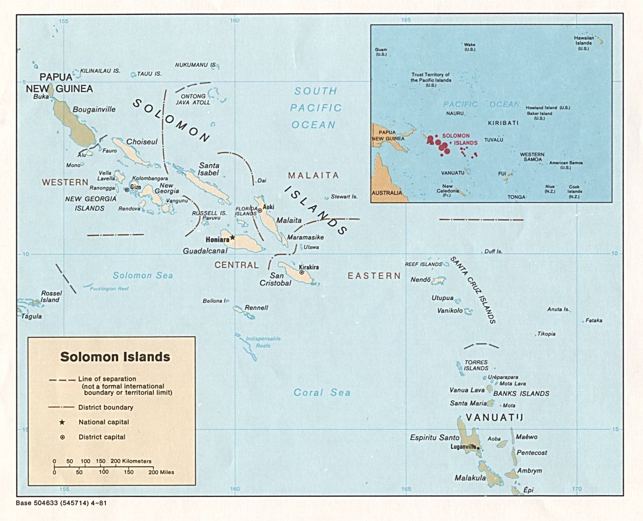
British sources:
- Britannica Encyclopaedia
- British Admiralty
- British Solomon Islands Protectorate boundaries, [17]
- New Guinea administrative divisions
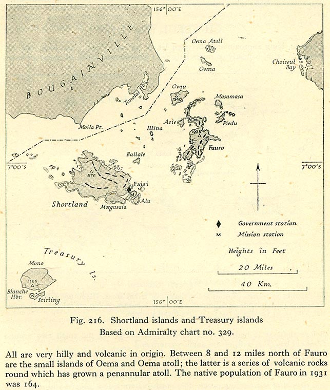
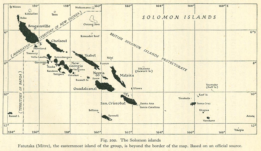
![[17]](http://www.lib.utexas.edu/maps/historical/pacific_islands_1943_1945/british_solomon_islands_districts.jpg)
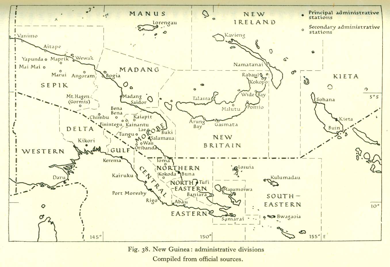
U.N. sources:
I'm sure you can find a lot of sources, where Treasury Islands, Shortland Islands and Fauro Island are in Solomon Islands. The WikiPedia, as you know, is one of these sources.
As you know, dear RareLibra, we can find only ONE source where Treasury Islands, Shortland Islands and Fauro Island are shown as Papua-New Guinean. It is the Papua-New Guinea University site digital map. The rest of the maps (your and Aliasd) are this source replics.
Is it possible that all platoon is out of step?
Bogomolov.PL ( talk) 07:09, 11 July 2008 (UTC)
Are you flying with Aeroflot? Yaan ( talk) 14:38, 11 July 2008 (UTC)
Just so you are informed correctly, Bogomolov - you ARE allowed to edit your talk page. You can remove comments as you please, and this even includes warnings. It has history and precedent in Wikipedia. There is NO requirement that you MUST keep something on your own talk page - nor is it required to keep some 'shameful' other posts, such as warnings. So my conversation with you is over - and I am removing it. Please do not banter about this with me, thank you. If you continue to revert, I will report you for violating 3RR. Let's move on from here... and don't ever try to lecture me with a condescending tone of "dear" or otherwise. Rarelibra ( talk) 16:28, 11 July 2008 (UTC)
- You, RareLibra,
edited my text posted on your talkpage. I've surprised with this, in my opinion, it was not a correct behaviour. I've posted this comment:
- "The WikiPedia discussion principles make possible editing of the discussion text by its author only. You, dear RareLibra, can archive topics of your discussion page, not more.Only if somebody vandalized your page or posted rasist, political propaganda texts you, dear RareLibra, like everybody have delete such kind of texts."
- I'm sure, RareLibra, you remember that deleted portion of my text was a set of the links to the CIA maps (in public property).
- I've got from you, RareLibra, on my talkpage the following:
- "Just so you are informed correctly, Bogomolov - you ARE allowed to edit your talk page. You can remove comments as you please, and this even includes warnings. It has history and precedent in Wikipedia. There is NO requirement that you MUST keep something on your own talk page - nor is it required to keep some 'shameful' other posts, such as warnings."
- As I don't want be misunderstood I will cite the
Talk_page_guidelines#Editing_comments (editing guideline for WikiPedia):
- "It is not necessary to bring talk pages to publishing standards, so there is no need to correct typing errors, grammar, etc. It tends to irritate the users whose comments you are correcting. Do not strike out the comments of other editors without their permission'."
- "Never edit someone's words to change their meaning, even on your own talk page."
- So, RareLibra, you cannot edit my comments posted on your talk page. You can archive them only (as I've noted in my first comment).
- Bogomolov.PL ( talk) 06:53, 14 July 2008 (UTC)
- What you have quoted above is only in relation to ARTICLE TALK PAGES, not a user talk page. Rarelibra ( talk) 18:41, 14 July 2008 (UTC)
Check out this article about how Google Earth has replaced it's current images of New Orleans with pre-Katrina images. Nice. So let the world think there is no destruction. Another reason why we cannot trust Google. If you want to respond ONLY to this, feel free (I'm through with the previous topic). Rarelibra ( talk) 19:18, 11 July 2008 (UTC)
The topic of this discussion is not a Google Map or Virtual Earth cartographic quality. These sources are commercial and can not be more relevant than official or encyclopedic sources. You invited me to check your map Papua New Guinea LLGs.png. This kind of map checking is normal in professional map production. I've noticed inconcistency in ALL availiable for me on a moment on-line mapping sources (Google Map and Virtual Earth too) and your map.
Later (14, 15 of May) we had e-mail coversation out of WikiPedia. In this opinions exchange I've added more sources claiming Treasury Islands, Shortland Islands and Fauro Island are the Solomon Islands property. This kind of discussion is completely correct for the encyclopedic quality improving. As you, RareLibra, pointed on my map mistakes.
You, RareLibra, 2 months later posted this on my talkpage, where informed me about Google and MicroSoft online mapping sources innacuracy. This, in your opinion, changed the situation - Treasury Islands, Shortland Islands and Fauro Island now can be Papua New Giunean, not the Solomon Islands.
After this declaration I've posted 18 availiable sources of government(U.S. Dept of State, C.I.A, Australian Defence Ministery, British Amiralty etc.), international (U.N.), ecyclopedic (Britannica) and etc. Today I can add one more, the 19-th, source: U.N. Map of vicinity of Bougainville island. So the question of Treasury Islands, Shortland Islands and Fauro Island is not a question of political dispute, but the question of quality of map used for your map creation. And, of course, is not any question of Google Map quality.
My intention is to improve the WikiPedia maps quality, even if these maps were made by you. We (you or me) cannot decide these islands belonging. The relevant sources have to decide this. Bogomolov.PL ( talk) 10:19, 14 July 2008 (UTC)
Listed sources on WikiPedia Commons are divided into two groups:
Larger one depicts Treasury Islands, Shortland Islands and Fauro Island as Solomon Islands territory ("YEA"), on a left side.
Small one depicts Treasury Islands, Shortland Islands and Fauro Island as Papua New Guinea territory ("NAY"), on a right side.
This inconsitency in WikiPedia is a problem to resolve. Would you, RareLibra, make steps forward to resolve it?
Bogomolov.PL ( talk) 16:33, 14 July 2008 (UTC)


.png)


You are greatly mistaken, Bogomolov. Just so you are informed correctly, here you go:
If you read the policy HERE, you will see it states
Policy does not prohibit users, including both registered and anonymous users, from removing comments from their own talk pages, although archiving is preferred.
Important exceptions may include declined unblock requests (while blocks are still in effect), confirmed sockpuppetry notices, or for anonymous editors, shared IP header templates. In these cases it may be legitimate in order to keep a user from gaming the system. Such templates are intended not only to communicate with the user in question, but to display important information about blocks and sockpuppetry.
As you can see, it IS NOT REQUIRED for a user to keep information on their talk page.
Also, please note the policy HERE, where it states
If a user removes a comment from their own talk page, (legitimate or not), it should remain removed. By removing the comment, the user has verified that they have read it. The comment is still in the page history, so it is not important to keep it visible just to prove that the user was told about it.
Users who repeatedly restore the same comment to another user's talk page may be blocked for violating the three-revert rule or harassing another user, regardless of if the talk page is for a registered or unregistered "anonymous" editor.
so as you can see, again, it is NOT REQUIRED for me to keep your comments on my talk page. In fact, I am warning you now - if you persist to put up stuff again, I will get an administrator involved to help clarify with you. I am DONE talking about island maps with you - I was trying to point out the GROSS INCONSISTENCIES in Google's data.
No more discussion with you, if you continue to act like you do. Please don't clutter my talk page with maps and such. Remember what it states above - you can violate the 3RR rule if you continue to restore that information on my talk page.
Rarelibra ( talk) 18:39, 14 July 2008 (UTC)
Well I'm new to mongolian geographical names - I just see that Egiin Gol is with Gol and Üür gol is with gol... -- katpatuka ( talk) 14:12, 10 September 2008 (UTC)
Several weeks ago I've got the complete set of Mongolian (2003 issue) topo maps (1:500 000, in Mongolian). I think it can be used as official(=relevant) source for the actual Mongolian toponyms. Romanization rules are: Wikipedia:Naming conventions (Mongolian), so Ih-Uul is not correct, but Ikh-Uul only. Bogomolov.PL ( talk)
- Are those offline sources downloadable? Otherwise it won't make sense to other users... -- katpatuka ( talk) 14:22, 10 September 2008 (UTC)
I think you forgot to move the main page (or was this impossible)? I prefer "Ulaanbaatar", so I won't move this myself. Just let you know. Regards, Yaan ( talk) 15:36, 10 September 2008 (UTC)
If you are a
cartographer wouldn't you like to join
OpenStreetMap? Because of their
licensing policy there could be created nice looking maps without any copyright constraints. Especially the
cycle map creates beutiful overlayed topographic maps using NASA's SRTM data...
The main problem is that there are still huge amounts of white areas which need to be filled as well as country and province borders to be drawn! If you don't know OSM yet just drop an eye on it ;-) --
katpatuka (
talk)
08:40, 16 September 2008 (UTC)
Hi, I just recognized a problem with the length of the Egiin Gol river. Hovsgolian source (M.Nyamaa) says it is 535 km, statistical yearbook 2007, p. 75, says it is 475. My guess is that the statistical yearbook is probably the more respectable source, but in any way it might be better to check one or two more sources. Any idea where to look (except using a pair of compasses) ? Yaan ( talk) 11:42, 22 October 2008 (UTC)
Hi, may I ask what length exactly you measure? I assume it is the total length of a set of lines that roughly follow the river's centerline, but did you use straight lines or (non-linear) splines, and how exactly did you determine the location of the knots, i.e. where the individual lines or splines end? Regards, Yaan ( talk) 14:58, 11 November 2008 (UTC)
- Actually, a polyline can make river length longer, too. For example, if you approximate the circumference of a circle of radius 1 with vertical or horizontal lines of length 0.01 only (like, neighbouring pixels), you will get a total legnth of 8, when it should only be around 6.3 (pi*2). Even if you allow 45% lines (like, between pixels that share a common corner) you might still be too long I guess. That is why I asked about the location of the knots or - in a polyline - corners. My guess is you have lines of completely arbitrary degrees, but .. I'd still like to know for sure. Regards, Yaan ( talk) 16:51, 13 November 2008 (UTC)
An image or media file that you uploaded or altered, Image:Mongolia Arhangay 2005 sum.png, has been listed at Wikipedia:Images and media for deletion. Please see the discussion to see why this is (you may have to search for the title of the image to find its entry), if you are interested in it not being deleted. Thank you. Latebird ( talk) 13:45, 7 December 2008 (UTC)
Hi there! If you got a moment, would you be able to add anything to the discussion here? Thanks!— Ëzhiki (Igels Hérissonovich Ïzhakoff-Amursky) • ( yo?); 15:12, December 15, 2008 (UTC)
Hello! I have tried to make a map with district names on the basis of your map. It looks fine in Inkscape but in IExplorer I can only see black squares instead of text. Do you see the same? How can one fix it? Thanks. Ivan Volodin ( talk) 14:19, 28 December 2008 (UTC)
Hi, I just uploaded that map here. The image is a bit raw currently because the university computers have no useful image processing software, feel free to cut it a bit. Also the quality of the scan is not as good as I expected. So hopefully Berlin State Library will one day digitize their map collection. I think that the river that enters from the right at J-26 is Shishged gol, and that the one that joins Shishged gol from northern direction at J-23 is Bilin gol (B-e(or a)-l-i-? gh-o-o-l). But you might want to check with someone who can either read Mongolian or Chinese. Regards, Yaan ( talk) 14:08, 23 January 2009 (UTC)
- I just realized that the maps apparently have been digitized and presented to the President of Mongolia in order to let scientists in Mongolia have easy access ( "Gleichzeitig wurde dem Staatspräsidenten die historische mongolische Kartensammlung der Staatsbibliothek zu Berlin in digitaler Form überreicht, damit die Wissenschaftlerinnen und Wissenschaftler vor Ort mittels der DVDs einen unkomplizierten Zugang zu diesem Material haben."). Now we only need to find out whether those maps are accessible online at http://www.staatsbibliothek-berlin.de, or figure out just how we can get a copy of that DVD! Yaan ( talk) 14:18, 23 January 2009 (UTC)
Have you checked the sources I provided? They formally became ZATOs on January 19, 2009.— Ëzhiki (Igels Hérissonovich Ïzhakoff-Amursky) • ( yo?); 20:36, February 5, 2009 (UTC)
- I don't know if it is available online, but I copypasted the entire decree (without the appendix, which is basically just a description of the borders) to
this page, to save you time looking for it. The one for Zvyozdny gorodok reads pretty much along the same lines. Cheers,—
Ëzhiki (Igels Hérissonovich Ïzhakoff-Amursky) • (
yo?); 20:45, February 5, 2009 (UTC)
- It will take two years to complete/amend the appropriate legislative acts and to start re-organizational processes (and possibly establish some commissions and committees overseeing the transformation ;)). As for the status itself, it is effective 1/19/9—item 1 orders the transformation, and item 5 clarifies that it is effective upon signing. If the change of status were to take effect two years from now, there would have been a clause saying something like "считать ЗАТО образованным с такой-то даты".— Ëzhiki (Igels Hérissonovich Ïzhakoff-Amursky) • ( yo?); 21:32, February 5, 2009 (UTC)
In regards to the article change on Latvia: "known" to "understand". My implication was that the majority of older Latvians understand (i.e. can speak and comprehend the Russian language.) To simply say they "know" Russian can seem to imply they merely are "aware" of the Russian language. It was just a grammatical change. Yes, of course most older ethnic Latvians were taught Russian and can speak and comprehend it. ExRat ( talk) 21:16, 14 February 2009 (UTC)
Thank you very much for your help with the correct transliteration of the Confederation of Mongolian Trade Unions.-- Goldsztajn ( talk) 12:43, 21 February 2009 (UTC)
Sprawa tkwi w czymś innym. Dwa lata temu był mały spór dotyczący zagłębia węglowego (m.in. Upper Silesian Coal Basin, ale też GOP i ROW). Spór toczył się zarówno na Wikipedii jak i poza nią. Ogólnie przyjęto, że Górnośląskie Zagłębie Węglowe to obszar metropolitalny i artykuł o zagłębiu (czyli o gospodarce) dotyczył obszaru metropolitalnego i stąd spór. Ktoś wpadł na bardzo interesujący pomysł, aby utworzyć osobne artykuły o zagłębiu i aglomeracjach. Tak też zrobiłem. Hasło Upper Silesian Coal Basin które już dawniej poprawiono jest o polsko-czeskim zagłębiu węglowym i istnieje osobny artykuł (utworzony wczoraj) o polsko-czeskim obszarze metropolitalnym (obejmującym obszar głównie zagłębia), ale o urbanistycznym tworze a nie przemysłowym. I byłoby wszystko dobrze jakby Polaron się nie mieszał w sprawy o których nie ma pojęcia. Jego małą wiedzę na temat tego obszaru metropolitalnego widać choćby w tej edycji gdzie np. część województwa małopolskiego (Lesser Poland Voivodeship) czyli np. Chrzanów czy Oświęcim podpiął pod szerszą definicję (tą 5 milionową) a nie konurbacji katowickiej (2,7 do 3 mln) oraz pisze że Racibórz tworzy 100,000 obszar metropolitalny. To tak jak napisać, że 10,000 miasteczko to metropolia ;p LUCPOL ( talk) 15:55, 15 March 2009 (UTC)
- Ja nie wandalizowałem tabelki. Dokonywałem zmian ale to nie były wandalizmy. Wracając do Polarona, mój angielski jest na poziomie en-1, cokolwiek piszę po angielsku (chodzi o złożone zdania) wymaga ode mnie trochę wysiłku - jeśli chcę aby to było zrozumiałe dla innych. Jeśli możesz to wytłumacz Polaronowi co trzeba.
LUCPOL (
talk)
16:42, 15 March 2009 (UTC)
- Napisałeś "Polaron ma rację co do różnicy pomiędzy urban area i obszarem metropolitalnym" - ma taką samą rację co ja. O różnicy pomiędzy urban area i obszarem metropolitalnym wiemy oboje to samo. I nasz spór w ogóle nie dotyczy sprawy urban area vs obszar metropolitalny. Jeśli natomiast chodzi o przykład z Katowicami i Ostravą to muszę cię zmartwić - podałeś zły przykład. Katowice i Ostrava leżą w innych państwach więc Czech mieszkający w Ostravie nie ma po co przyjeżdżać do Katowic i odwrotnie. Ale mam i dobrą wiadomość. Jest dobre połączenie komunikacyjne regionów Katowic i Ostravy, są bezpośrednie połączenia drogowe i kolejowe, budowana jest autostrada a nawet planowana była szybko kolej (czytałem w prasie około 2 lata temu).
LUCPOL (
talk)
18:07, 15 March 2009 (UTC)
- Co do rzekomych wandalizmów - odpowiedź jest prosta: rewertowałem a nie analizowałem edycji by IP. To czy edycja IP była wandalizmem nie brałem pod uwagę. Wróćmy jednak do tematu. LUCPOL ( talk) 18:30, 15 March 2009 (UTC)
- Ohhhh. Pomyliłeś się. To jest prawidłowa edycja. Katowice metropolitan area to nie Silesian metropolitan area. Widocznie pomyliłeś jedno z drugim. Poza tym przyjrzyj się temu: [18]. Tam pisze, że Silesian metropolitan area składa się (pisząc wprost) z regionów Katowickiego, Rybnickiego, Bielskiego i Ostravskiego. Katowice metropolitan area jest prawie tym samym co Katowice urban area (obejmuje kilka miejscowości więcej) i kompletnie nie ma podstaw aby porównać to do great Silesian metropolitan area. Mało tego, nawet Polaron powinien to poświadczyć, źródło o 3 mln pisze tylko o regionie katowickim (Katowice metropolitan area), natomiast 5 mln to Silesian metropolitan area. Tak czy siak, tabela poprawiona i powinno być dobrze. LUCPOL ( talk) 18:28, 15 March 2009 (UTC)
- PS. Zauważyłem, że napisałeś do Polarona. Problem w tym że prawdopodobnie to już koniec sporu (mam nadzieję że się nie mylę). W artykułach jest już kompromis, choć znając zachowanie Polarona to może będzie chciał znów wprowadzać tylko swoją monopolową wersję i znów będzie krecha.
LUCPOL (
talk)
18:38, 15 March 2009 (UTC)
- Jeśli tak ma wyglądać dyskusja to nie ma to większego sensu. Ja cenię sobie czas a widzę, że muszę nie dość że 10 razy tłumaczyć podobne rzeczy to jeszcze odpowiadać na zakończone sprawy (choćby te rewerty i rzekome wandalizmy) oraz coraz to bardziej zagłębiać się w szczegóły. Odnośnie moich revertów już pisałem - revertowałem automatycznie bez dokładnej analizy co Polaron zrewertował wcześniej. Znam edycje Polarona już od miesięcy i wiem że on się w tych listach za bardzo rządzi. Moje rewerty były tylko skutkiem jego zachowania i miały dać do myślenia Polaronowi. Tak czy siak moje rewerty w tych listach zakończyły się. Temat zamknięty i nie mam zamiaru go ciągnąć. Odnośnie obszarów - ma pan wyjątkową koncepcję, że zacytuję "obszar dojazdowy (metropolitalny)". Jeśli rzeczywiście tak Pan uważa to może być problem z mediacją pomiędzy nami bo Pana wiedza ta w/w tematy jest niewielka. Oczywiście bez obrazy. Jeśli chodzi o redirect to przekierowanie Katowice metropolitan area do Silesia metropolitan area jest absurdem. To jest tak jak zrobić przekierowanie "Mazowsze" do artykułu "Polska" a nie do bliższego "województwo mazowieckie". Przekierowanie Katowice metropolitan area do Katowice urban area nie jest rozwiązaniem idealnym ale zdecydowanie lepszym bo Katowice urban area wraz z sąsiednimi gminami tworzy Katowice metropolitan area. Proszę, abyś nie ciągnął tego tematu.
LUCPOL (
talk)
19:38, 15 March 2009 (UTC)
- Wandalizm to celowe działanie w celu zniszczenia czegoś. Moje reverty w listach wandalizmem nie są. Prędzej są pomyłką lub pochopnym działaniem. Dobra kończymy z tym tematem. Mam nadzieję że już wystarczająco wyjaśniłem sprawę i nie zobaczę już kolejnych postów na ten temat. LUCPOL ( talk) 19:54, 15 March 2009 (UTC)
- Jeśli tak ma wyglądać dyskusja to nie ma to większego sensu. Ja cenię sobie czas a widzę, że muszę nie dość że 10 razy tłumaczyć podobne rzeczy to jeszcze odpowiadać na zakończone sprawy (choćby te rewerty i rzekome wandalizmy) oraz coraz to bardziej zagłębiać się w szczegóły. Odnośnie moich revertów już pisałem - revertowałem automatycznie bez dokładnej analizy co Polaron zrewertował wcześniej. Znam edycje Polarona już od miesięcy i wiem że on się w tych listach za bardzo rządzi. Moje rewerty były tylko skutkiem jego zachowania i miały dać do myślenia Polaronowi. Tak czy siak moje rewerty w tych listach zakończyły się. Temat zamknięty i nie mam zamiaru go ciągnąć. Odnośnie obszarów - ma pan wyjątkową koncepcję, że zacytuję "obszar dojazdowy (metropolitalny)". Jeśli rzeczywiście tak Pan uważa to może być problem z mediacją pomiędzy nami bo Pana wiedza ta w/w tematy jest niewielka. Oczywiście bez obrazy. Jeśli chodzi o redirect to przekierowanie Katowice metropolitan area do Silesia metropolitan area jest absurdem. To jest tak jak zrobić przekierowanie "Mazowsze" do artykułu "Polska" a nie do bliższego "województwo mazowieckie". Przekierowanie Katowice metropolitan area do Katowice urban area nie jest rozwiązaniem idealnym ale zdecydowanie lepszym bo Katowice urban area wraz z sąsiednimi gminami tworzy Katowice metropolitan area. Proszę, abyś nie ciągnął tego tematu.
LUCPOL (
talk)
19:38, 15 March 2009 (UTC)
- Napisałeś "Polaron ma rację co do różnicy pomiędzy urban area i obszarem metropolitalnym" - ma taką samą rację co ja. O różnicy pomiędzy urban area i obszarem metropolitalnym wiemy oboje to samo. I nasz spór w ogóle nie dotyczy sprawy urban area vs obszar metropolitalny. Jeśli natomiast chodzi o przykład z Katowicami i Ostravą to muszę cię zmartwić - podałeś zły przykład. Katowice i Ostrava leżą w innych państwach więc Czech mieszkający w Ostravie nie ma po co przyjeżdżać do Katowic i odwrotnie. Ale mam i dobrą wiadomość. Jest dobre połączenie komunikacyjne regionów Katowic i Ostravy, są bezpośrednie połączenia drogowe i kolejowe, budowana jest autostrada a nawet planowana była szybko kolej (czytałem w prasie około 2 lata temu).
LUCPOL (
talk)
18:07, 15 March 2009 (UTC)
I believe the current state of affairs (at least at the time that I wrote this) is now acceptable to both LUCPOL and myself so I don't forsee any further back and forth. Thank you for your efforts and it would probably be good if you can keep an eye on both of us to make sure that all the relevant articles maintain some level of reliability. I believe the main issue was identifying the immediate Katowice metropolitan area as the wider Silesian-Moravian region. In any case, I think it's all good now. Thanks. -- Polaron | Talk 19:17, 15 March 2009 (UTC)
- Mówiłem, że wypracowaliśmy z Polaronem pewien kompromis. Teraz trzeba tylko zadbać aby się on utrzymał. LUCPOL ( talk) 19:38, 15 March 2009 (UTC)
Munku-Sardyk - glaciers?
Hi, I understand the source I used for creating the article says there are some glaciers (or "mös gol", whatever it means) on that mountain, but I can't see any on google maps. Do you have any idea? Regards, Yaan ( talk) 11:44, 27 March 2009 (UTC)
Could you please check the source you cite for the updated population numbers in Provinces of Uzbekistan? The tables in the cited reference end with page 175 ("Paid services rendered to the population") and there is no page 176 that you give as the source for population by province. Thank you. -- Zlerman ( talk) 11:51, 9 April 2009 (UTC)
- Thanks for your reply. It was a false alarm on my part: I have now found the missing page (p. 176) and I see your numbers in the first column under "Average resident population". -- Zlerman ( talk) 13:25, 9 April 2009 (UTC)
Hi there! Would you be able to amend the maps of Moscow Oblast in administrative divisions of Moscow Oblast to account for Losino-Petrovsky and Elektrogorsk becoming oblast-level cities effective April 5? Thanks!— Ëzhiki (Igels Hérissonovich Ïzhakoff-Amursky) • ( yo?); 16:25, April 15, 2009 (UTC)
- You are right, it makes sense to wait until the urban okrugs corresponding to Vlasikha and Zvyozdny ZATOs are officially established. As for the boundaries, a textual description of the (administrative) boundaries is actually available in the Decrees of Jan 19, 2009—are they sufficient for you to do the map or are they too vague? The boundary posts are, unfortunately, all referred to by their numbers—I don't know how hard/easy it is for you to map them to the actual coordinates (I sure can't do it).—
Ëzhiki (Igels Hérissonovich Ïzhakoff-Amursky) • (
yo?); 17:34, April 15, 2009 (UTC)
- Well, I wish I could help, but I can't :) Good luck, and thanks!— Ëzhiki (Igels Hérissonovich Ïzhakoff-Amursky) • ( yo?); 17:45, April 15, 2009 (UTC)
Hi, I don't think the number of 1024 km from Ider gol source to Lake Baikal is very plausible. If we accept that Ideriin gol is around 452 km long, then that would leave less than 600 km between lake Baikal and the confluence of Ideriin gol and Delgermurun. That just does not seem convincing when looking at a map.
Could the 1024 vs. 992 be just the result of two different measurements, with different maps, maybe? Yaan ( talk) 16:00, 5 May 2009 (UTC)
-
seems like other river lengths have their problems, too. :)
Yaan (
talk)
17:21, 29 March 2010 (UTC)
- Direct measurements are available now using the satellite imagery (vectorizing of the main stream), but the main stream definitions are sometimes very subjective. An other problem - reservoires: they are making a river shorter as a lot of meanders was covered with water, so waterway is straight.
Bogomolov.PL (
talk)
18:32, 29 March 2010 (UTC)
- In this case it seems someone simply mixed up the second and third digits. Or at least that is what the german sources on the talk page say. They also say that when you accept the 1320 km length, some numbers for the Alpine Rhine (in Switzerland, Liechtenstein and Austria) just don't add up. The Rhine has been straightened, but that happened before the 1320 km length came up.
- I completely understand that the definition of what is the main stream is very subjective.
In factBtw. I have been wondering if themain streamcenter line (or skeleton line?) of a river can become arbitrarily long if the scale is just small enough (like fractal coast lines), or if there is a limit? Yaan ( talk) 18:46, 29 March 2010 (UTC)- Natural objects measuring every time is dealing to the real world fractal nature, but using of the real maps (photos) is making the limits. Before the digital methods were invented the curvimeter was in use or a simple trick - regular lines palette was overlapping and river crossings with these lines counted: nuber of crossings reflects a river length. Several measurements with palette random positioning were used, next conventional statistic methods.
Bogomolov.PL (
talk)
19:11, 29 March 2010 (UTC)
- Center line definition is not a problem, but every time we need to make a decision what riverbet is main and what we concider secondary. Main ambiguity source comes with these private decisions. Bogomolov.PL ( talk) 09:58, 31 March 2010 (UTC)
- Natural objects measuring every time is dealing to the real world fractal nature, but using of the real maps (photos) is making the limits. Before the digital methods were invented the curvimeter was in use or a simple trick - regular lines palette was overlapping and river crossings with these lines counted: nuber of crossings reflects a river length. Several measurements with palette random positioning were used, next conventional statistic methods.
Bogomolov.PL (
talk)
19:11, 29 March 2010 (UTC)
- Direct measurements are available now using the satellite imagery (vectorizing of the main stream), but the main stream definitions are sometimes very subjective. An other problem - reservoires: they are making a river shorter as a lot of meanders was covered with water, so waterway is straight.
Bogomolov.PL (
talk)
18:32, 29 March 2010 (UTC)
- I see. I think this has been dealt with by some hydrographic authorities for most of the Rhine, i.e. geographers can just use the length of that stream that the ships use. But I find that centerline problem also interesting. My guess is it can not be arbitrarily long (if there is a finite-length path through the river), but I wonder if someone has dealt with this.
Yaan (
talk)
10:15, 31 March 2010 (UTC)
- As with see straits - length is defined by the ships fairway, but with rivers upper parts where is no fairway - we are deciding. Bogomolov.PL ( talk) 10:38, 31 March 2010 (UTC)
- I see. I think this has been dealt with by some hydrographic authorities for most of the Rhine, i.e. geographers can just use the length of that stream that the ships use. But I find that centerline problem also interesting. My guess is it can not be arbitrarily long (if there is a finite-length path through the river), but I wonder if someone has dealt with this.
Yaan (
talk)
10:15, 31 March 2010 (UTC)
Bogomolov, I appreciate your mapping work. However, it has a mistake. Orkhon province is painted in red, where Elbegdorj won according to your montsame source. In addition, in Ulaanbaatar city, Bagakhangai and Nalaikh are the least populated area and geographically very small but you show it very big. Can you edit this and reload your new map? Thanks. Compbok ( talk) 02:24, 12 June 2009 (UTC)
Hi, do you have a blank sum map and ulaanbaatar map? -- Chinneeb my talk 11:13, 30 June 2009 (UTC)
Just giving you a heads up that I made most of the changes per your suggestions and responded to all of the map issues (those raised at the Talk page and the EB Talk page) at File talk:EasternBloc BorderChange38-48.svg. As an aside, I found many of your comments to be helpful, and the map making/editing process overall to be enjoyable. Mosedschurte ( talk) 22:25, 2 July 2009 (UTC)
Hi again,
The list at aimags of Mongolia currently states that Bayan-Ulgii has 13 sums, while the 2006 statistical yearbook says it should be 14 (p.64). Just wanted to let you know. Yaan ( talk) 19:08, 9 November 2009 (UTC)
Thanks for adding cited and sourced content to the Kazakhs article. Both your edits and the new content look great! — Kralizec! ( talk) 15:37, 18 January 2010 (UTC)
I don't understand what you meant... Can you give me a link to the talk page? Calliopejen1 ( talk) 17:20, 11 February 2010 (UTC)
- Hmm, those weren't my questions. Maybe Blofeld said that. In any event, thanks for your help in bringing it to people's attention. Calliopejen1 ( talk) 18:39, 11 February 2010 (UTC)
Ahh, thanks, good call. Don't know where my head was, I was only looking at transliteration based on the Kazakh name and even didn't think to check the books. What's the best course? A simple cut and paste from Bokei to Bukey, or a delete/move? Otebig ( talk) 20:50, 1 April 2010 (UTC)
- Bogomolov, it is rude and inappropriate to call Aizhol a "vandal" as you did here, and you should carefully read both WP:NOTVAND and WP:AFG to see why. Aizhol was trying to make the article more accurate by removing something he believed was incorrect. You then provided sources backing up your point. Those are both parts of writing an article, and there is nothing inappropriate about Aizhol's edits or your counter-edits which included sources. For you to label these edits, which were part of a normal disagreement over facts, as "vandalism" is a complete misuse of the term. Aizhol did not engaging in an edit war, did not try to actively disrupt the article, did not blank the page or add inappropriate tags - in short, nothing that qualifies as vandalism. Please do not throw around accusations, as it doesn't lead to anything productive, and remember to assume good faith. Otebig ( talk) 13:02, 5 May 2010 (UTC)
- When an advanced user made the reversion or removal of encyclopedic material, or of edits with the comment: "According to "Зиманов С.З. Россия и Букеевское ханство" it did reach those rivers" this is a mistification as this information is not present in this (or any other) book content. It is is not a truth and User:Aizhol is mistifying me or other users as we know from his/her edits the knolege of the topic. The same user next makes an other one mistification placing a hoax about Bukey Horde area value. This advanced user with the knolege of this topic claims the area value looking very accurate: "The land spread on 921445 square kilometers". We remember his/her attempt to "expand" Bukey Horde area up to Volga and Ural rivers. Now this advanced user is making an other step - area value mistification. The not true value was 1300 % larger then real value. If somebody is "on a level" (I'm sure of User:Aizhol knolege) he/she knows Kazakhstani area - 2.7 mln sq km, so 921445 sq km is over ⅓ of the national area (former Bukey Horde area covers two districts only). Were these two mistifications a "good faith"? Only if the editor was an experimenting new user. That is why according WP:VANDTYPES I was qualifying this behaviour a "Vandalism that is harder to spot, or that otherwise circumvents detection. This can include adding plausible misinformation to articles, (e.g. minor alteration of facts or additions of plausible-sounding hoaxes)". Bogomolov.PL ( talk) 16:18, 5 May 2010 (UTC)
|
| On June 30, 2010, Did you know? was updated with a fact from the article Oyu Tolgoi mine, which you created or substantially expanded. You are welcome to check how many hits the article got while on the front page ( here's how, quick check ) and add it to DYKSTATS if it got over 5,000. If you know of another interesting fact from a recently created article, then please suggest it on the Did you know? talk page. |
— Rlevse • Talk • 18:04, 30 June 2010 (UTC)
Not sure if this is interesting for you, but this article has a map with horoo boundaries on p.10. It seems to cover only a part of the area that your düüreg map covers, though. And I wonder if the population density numbers for the areas NW of the city center are correct. Yaan ( talk) 23:47, 26 January 2011 (UTC)
Also, do you know the difference between 'horoo' and 'horoolol', and which of the two is synonymous with 'mikrorayon'? Yaan ( talk) 23:53, 26 January 2011 (UTC)
- Yes, I'm watching this khoroo boundaries problem. Online is a vector map see Нутаг дэвсгэр, but it does not show the remote city parts in the Khentei mts dales and in Nalakh and Bagakhangai and Baganuur (as the source you provided - but I didn't know this source, thank you). That is why I didn't create a khoroo map.
- Khoroo - is an administrative unit, Khoroolol is a микрорайон (for example built by Moscow in UB), but wery close in sens. But Khoroo has also a sens of "kommittee" and "regiment", but хороолол - no, so хороолол is more informal.
- About the densities: is possible the author used statistics not related to the graphics (values were calculated for the real edges without mountaineous unbuilt territories, but at the map were filled the formal khoroo areas). Bogomolov.PL ( talk) 07:06, 27 January 2011 (UTC)
- Thanks a lot for the link to the other map. Any idea where else one could get the bus/microbus data? It would make a nice addition to a homework we're currently dealing with, but copying it all by hand one line at a time seems too cumbersome. Regards, Yaan ( talk) 17:14, 28 January 2011 (UTC)
Also, re. your question about a bus grid map, do you know where I could find one? Newer than this one? 07:21, 2 February 2011 (UTC)
If possible, please comment at Talk:Changkya Khutukhtu about the correct Mongolian equivalent of this title. I'm almost certain that it should be Жанжаа хутагт (Janjaa Hutagt), but I'd like additional input before adding that to the article.— Greg Pandatshang ( talk) 18:40, 19 February 2011 (UTC)
Regarding ( this edit); please note that {{ Coor dm}} is deprecated in the English Wikipedia; we use {{ Coord}}. Cheers, Andy Mabbett (Pigsonthewing); Talk to Andy; Andy's edits 11:41, 14 January 2012 (UTC)
OK! I will stop - it was a mistake! I only wanted to knew - can I sawe all in English wiki. I undestud! Sorry! - Губин Михаил —Preceding undated comment added 20:42, 28 May 2012 (UTC)
I have created some articles: Mongolian Wikipedia, Erdenet Mining Corporation. Please look at them! - Губин Михаил, 29 May 2012 (UTC)
Can you take a look at this article and say whether it should be renamed? Even though it's a very important subject currently there's little interest in it. Thank you. Nataev ( talk) 08:42, 12 October 2012 (UTC)
This article for factual correctness, comprehension and title (I suggested a more simpler one on the talk page). Regards. — Preceding unsigned comment added by 109.170.84.179 ( talk) 15:31, 2 April 2013 (UTC)
Do you have, or can you make, a blank map of File:Ulan Bator subdivisions.png, so that for elections we can add what sections were won by different candidats, similar to the one we have for the country File:Mongolia_blank.svg. -- kelapstick( bainuu) 05:31, 28 June 2013 (UTC)
Hi,
you can do a favour for me and update this GDP curve till end of 2014: https://commons.wikimedia.org/wiki/File:Transcaucasia_GDP_PPP_in_constant_prices_per_capita.png
It is exactly what I need :)
Useful were also af future estimation, e.g. with dotted lines. I can promise you: Highly likely high ranking NATO members would see your graph. Or tell me simply, where I can find out the data "GDP per capita (PPP, 2005 constant prices, US$)" that fit to your curve. The data I found are real prices in $ and do not fit to your graph.
Perhaps we can discuss it: falk.oberdorf@shape.nato.int
Thanks, — Preceding unsigned comment added by Flk-Brdrf ( talk • contribs) 14:02, 6 January 2015 (UTC)
Hi, Could you say something on this edit war? user Rajmaan is claiming Oirats Mongols are not Mongols and the "Mongol" identity was defined by the Qing. No one supported him, but he keeps posting his claims. http://en.wikipedia.org/wiki/Talk:Oirats#Edit_warring Thanks. 142.255.6.214 ( talk) 08:08, 17 March 2015 (UTC)
Hi,
You appear to be eligible to vote in the current
Arbitration Committee election. The
Arbitration Committee is the panel of editors responsible for conducting the Wikipedia
arbitration process. It has the authority to enact binding solutions for disputes between editors, primarily related to serious behavioural issues that the community has been unable to resolve. This includes the ability to impose
site bans,
topic bans, editing restrictions, and other measures needed to maintain our editing environment. The
arbitration policy describes the Committee's roles and responsibilities in greater detail. If you wish to participate, you are welcome to
review the candidates' statements and submit your choices on
the voting page. For the Election committee,
MediaWiki message delivery (
talk)
16:30, 23 November 2015 (UTC)
ArbCom Elections 2016: Voting now open!
Hello, Bogomolov.PL. Voting in the 2016 Arbitration Committee elections is open from Monday, 00:00, 21 November through Sunday, 23:59, 4 December to all unblocked users who have registered an account before Wednesday, 00:00, 28 October 2016 and have made at least 150 mainspace edits before Sunday, 00:00, 1 November 2016.
The Arbitration Committee is the panel of editors responsible for conducting the Wikipedia arbitration process. It has the authority to impose binding solutions to disputes between editors, primarily for serious conduct disputes the community has been unable to resolve. This includes the authority to impose site bans, topic bans, editing restrictions, and other measures needed to maintain our editing environment. The arbitration policy describes the Committee's roles and responsibilities in greater detail.
If you wish to participate in the 2016 election, please review the candidates' statements and submit your choices on the voting page. MediaWiki message delivery ( talk) 22:08, 21 November 2016 (UTC)
Hello, Bogomolov.PL. Voting in the 2017 Arbitration Committee elections is now open until 23.59 on Sunday, 10 December. All users who registered an account before Saturday, 28 October 2017, made at least 150 mainspace edits before Wednesday, 1 November 2017 and are not currently blocked are eligible to vote. Users with alternate accounts may only vote once.
The Arbitration Committee is the panel of editors responsible for conducting the Wikipedia arbitration process. It has the authority to impose binding solutions to disputes between editors, primarily for serious conduct disputes the community has been unable to resolve. This includes the authority to impose site bans, topic bans, editing restrictions, and other measures needed to maintain our editing environment. The arbitration policy describes the Committee's roles and responsibilities in greater detail.
If you wish to participate in the 2017 election, please review the candidates and submit your choices on the voting page. MediaWiki message delivery ( talk) 18:42, 3 December 2017 (UTC)
https://commons.wikimedia.org/wiki/File:Татьяна_Скоробогатова.jpg вот отсюда вырежьте!!!! Панн ( talk) 20:17, 29 July 2018 (UTC)
Hello, Bogomolov.PL. Voting in the 2018 Arbitration Committee elections is now open until 23.59 on Sunday, 3 December. All users who registered an account before Sunday, 28 October 2018, made at least 150 mainspace edits before Thursday, 1 November 2018 and are not currently blocked are eligible to vote. Users with alternate accounts may only vote once.
The Arbitration Committee is the panel of editors responsible for conducting the Wikipedia arbitration process. It has the authority to impose binding solutions to disputes between editors, primarily for serious conduct disputes the community has been unable to resolve. This includes the authority to impose site bans, topic bans, editing restrictions, and other measures needed to maintain our editing environment. The arbitration policy describes the Committee's roles and responsibilities in greater detail.
If you wish to participate in the 2018 election, please review the candidates and submit your choices on the voting page. MediaWiki message delivery ( talk) 18:42, 19 November 2018 (UTC)
Thanks for your comments; yeah, it's still very much a work in progress, I hadn't thought about them being visible on Commons. Hrm. If you have any sources for any of those, I'd love to have them. It's a bit hard to find sources and information about most of these changes. You can see that most of my "outstanding questions" (I won't even think about making it public til I have all those cleaned up, I am absolutely not going to publish an incomplete list) are things that I've seen mentioned, or saw some map of, but need more information on. Though, a quick comment: Yes, the USSR had all the Kuril Islands, but they had the northern ones from day one. Only the southern ones were annexed [and remain disputed] in 1945. From what I understand. :) Also, if you had some source explaining the status of Bukhara and Khorezm, that would be awesome; all I've been able to find is they were PSRs, then SSRs, but never 'formally' made union republics, which would have involved their addition to the constitution... I think? Thanks! -- Golbez ( talk) 01:11, 13 January 2020 (UTC)
- Poking for when you have a chance to look at this, because I'd love to get your info. Thanks! :) -- Golbez ( talk) 22:12, 4 February 2020 (UTC)
![]() There is currently a discussion at
Wikipedia:Administrators' noticeboard/Incidents regarding an issue with which you may have been involved. The thread is
WP:NATIONALIST bickering on Wikipedia:Articles for deletion/Kyrgyz Confederation. Thank you.
—DIYeditor (
talk)
08:11, 5 February 2023 (UTC)
There is currently a discussion at
Wikipedia:Administrators' noticeboard/Incidents regarding an issue with which you may have been involved. The thread is
WP:NATIONALIST bickering on Wikipedia:Articles for deletion/Kyrgyz Confederation. Thank you.
—DIYeditor (
talk)
08:11, 5 February 2023 (UTC)
После блокировки юзера стоило бы и повторно номинировать статью Kyrgyz Khanate на удаление, если это разрешено (уж извините, в этом я чуток профан). Обратите внимание, после удаления Kyrgyz Confederation, заблоченный банально перекинул всё то что было на той странице и чуток поигрался с датами, то есть это буквально еле выдерживающая критику статья, которая основывается на слове "Khanate" из энциклопедии по христианству, а так, благодарю Вас за такую тяжёлую проделанную работу. Kazman322 ( talk) 18:15, 12 February 2023 (UTC)
Nomination for deletion of Template:Tashkent Labelled Map
![]() Template:Tashkent Labelled Map has been
nominated for deletion. You are invited to comment on the discussion at
the entry on the Templates for discussion page.
WikiCleanerMan (
talk)
23:45, 2 August 2023 (UTC)
Template:Tashkent Labelled Map has been
nominated for deletion. You are invited to comment on the discussion at
the entry on the Templates for discussion page.
WikiCleanerMan (
talk)
23:45, 2 August 2023 (UTC)
Hello! Voting in the 2023 Arbitration Committee elections is now open until 23:59 (UTC) on Monday, 11 December 2023. All eligible users are allowed to vote. Users with alternate accounts may only vote once.
The Arbitration Committee is the panel of editors responsible for conducting the Wikipedia arbitration process. It has the authority to impose binding solutions to disputes between editors, primarily for serious conduct disputes the community has been unable to resolve. This includes the authority to impose site bans, topic bans, editing restrictions, and other measures needed to maintain our editing environment. The arbitration policy describes the Committee's roles and responsibilities in greater detail.
If you wish to participate in the 2023 election, please review
the candidates and submit your choices on the
voting page. If you no longer wish to receive these messages, you may add {{
NoACEMM}} to your user talk page.
MediaWiki message delivery (
talk)
00:31, 28 November 2023 (UTC)
Pavel Leonidovich, did you have an attitude to MIIGAiK's " Red School" in a some time? If "yes" then write to me a message or call me direct, please! B.R.,
Alex Filippov gis_n_map (at) yahoo.com, (cell) —Preceding unsigned comment added by RedSchool ( talk • contribs) 06:35, 21 January 2009 (UTC)
I replied on the talk page for you. Let's work together on this and ensure that the information shown is most accurate. Thank you for your input! Rarelibra 16:39, 29 January 2007 (UTC)
- Hey - I have no source maps available for Mongolia - so if you have one in English that helps in the transliteration, that is an excellent contribution for making the information most accurate and up-to-date! Let me know if you need any assistance...
Rarelibra
14:12, 30 January 2007 (UTC)
- Thank you very much for this effort. There were lots of inaccuracies in the old maps. 132.239.145.119 22:01, 29 June 2007 (UTC)
Bogomolov - my software (MapInfo) does direct translation of Microstation files... so yes, I can view/use DGN format. Rarelibra 13:38, 9 February 2007 (UTC)
Hi, your new maps look nice. I only checked the first two of them so far, and noticed some inconsistencies with Bayan-Ölgii. As a minor point, you spelled Ölgii, Altantsögts, and Delüün without the umlauts. More importantly, my sources indicate that there is also a sum named Tsagannuur, which seems to occupy part of what you currently have as Nogoonnuur and possibly part of Ulaankhus. Any way to confirm this? -- Latebird 10:45, 30 March 2007 (UTC)
- It was great surprise for me- but umlauts was lost... Why? No idea. May be it was first aimag? I will fix umlauts soon. I will add sum population also. What with Цагааннуур? In Авто замын атлас it is shown like major settlement, but not sum centre. Administrative map 2006 does not show Цагааннуур sum. But Цагааннуур is present on sum list http://202.131.5.91/webs/aimags/02/stat_hun_am.htm. But this "sum" looks like "tosgon". Official population table shows: in sum centre (сумын тθв) is 1270 population (хун ам), nomad population is 258 (57 yurts). Aimag centre has more nomads: 680 (147 yurts).Rest of normal sums has 2/3 to 3/4 nomadic population. Note: sums list is in cyrillic alphabetic order, but aimag centre and Цагааннуур are out of order on the table bottom, and Цагааннуур after the city. So, my opinion - Цагааннуур is tosgon with small territory. We are back with tosgons - we have decide how note tosgons on the map. Bogomolov.PL 11:36, 30 March 2007 (UTC)
- In Dornogovi I added sum/sum centre population and notification for tosgon (two tosgons were OFFICIALLY noted in stat table) Bogomolov.PL 15:35, 30 March 2007 (UTC)
I don't think table vertical size is an issue. If we don't use a table, the result will still be long due to the sheer amount of information that needs to be put in. What's more, quite a few featured lists have very long tables, so I believe it is not a problem at all.
It's a pity that foundation dates are not available :( Well, I guess that can be address later; what's not there is not there...
Maps, those also can be addressed after the table is completed. User:Rarelibra has created overview maps for some federal subjects for this project; maybe he'll agree to make an overview map and a set of locator maps for Moscow Oblast as well. Of course, once we have the maps, the tricky part will be to figure out where to place them. I have that same problem with Adygea. If you have ideas, I'll be happy to hear them out.
Using my (future) table will be reasonable to make short district level table. Or it is possible add district statistics into first one? I don't think so. We can always try; that's as good an idea as any. Let's complete the main table first, though.
Of course we have all data to prepare in future every urban/rural settlement lokalities lists (articles?) I was leaning towards putting lists of rural localities into the articles about districts (see Giaginsky District for an example), and only indicating the number of rural localities per rural settlement (or even just the number of rural settlements and the number rural localities they include) in the overview lists such as this one. The benefits of such approach are that the main list is not overloaded with lists of each and every village, and that double-maintenance is avoided (otherwise, every time there is a change, one would need to amend both the main list and the district article). Cities/towns/urban-type settlements, on the other hand, can be listed in both places, as their numbers are a lot more manageable and changes do not occur as often.
In conclusion, before you start putting time into completing the final table, let me ask for an opinion of User:David Kernow, who's been of immense help in the past regarding these types of problems. I'm sure he'll have some valuable feedback for us to consider. Best,— Ëzhiki (Igels Hérissonovich Ïzhakoff-Amursky) • ( yo?); 14:39, 19 April 2007 (UTC)
Hi, I seem to remember a while ago you were looking for a map that shows the borders between Ulaanbaatars duuregs. Ulaanbaatars official website www.ulaanbaatar.mn does contain a map that gives at least a very good idea, but it needs Flash player and is really, really slow. The map is accessible from the main page (if it's in Mongolian, look out for gazrin zurag, at the next screen click on "orox"=enter). Then you'll get a map with some roads and the Tuul and Selbe rivers. On the upper right is a box with features that can be displayed. If don't choose a feature from the list, but the one checkbox above it ("Devsger ongo"), after a while the districts should show.
The website also contains some infos on the different duuregs incl. (some) population numbers, but unfortunately not the dates when the numbers were retrieved. The official statistics seem to unaccessible (except for no. of autobuses, cinemas, head of lifestock and some more). Or at least I always got a message that I understood as "do you tell your secrets to everyone?". Yaan 11:49, 22 May 2007 (UTC)
- It is nice, you remember my appeal. But UB map on www.ulaanbaatar.mn exists since 2006, I know this map. It is several maps on UB landuse office site. But! Problem is not with duureg boundaries in built up territories, but in moutanies which are UB parts (north from UB center). I've analysed all avaliable on-line maps and I have made more or less accurate boundaries on Google Map image for the Greater UB. I've discovered that Baganuur and Bagakhangai are exclaves. I have areas problem: we have very accurate (in ha) areas, I was checking my maps - if area I made is the same - OK, but boundaries for three ajacent duuregs (Чингэлтэй, Баянзурх, Баянгол)are unknown in nothern less pupulated mountain parts and so... I can not complete my job.
- Official statistics are accesible, UB has it's own statistics office in web [1], so I made table in Duureg article in WP.
- If you will find something with sum, khoroo or duureg boundaries, please, inform me. Thank you, Bogomolov.PL 13:22, 22 May 2007 (UTC)
Sorry of that... ;) But then we already have a better (if smaller) version on Commons. -- Latebird 10:26, 13 June 2007 (UTC)
Uhm, because the page is at Zamïn-Üüd, Zamyn-Üüd is (was?) a redlink when I changed them. If it's incorrect feel free to change. AllynJ 15:09, 14 June 2007 (UTC)
moved above comment here from user page
- I just moved that page to Zamyn-Üüd. It had been created with an incorrect title according to WP:MON. -- Latebird 16:50, 14 June 2007 (UTC)
Unfortunately, your "corrected" coordinates for Bayankhongor are not valid, still less located in Mongolia, as they have a latitude of > 90°. You seem to have transposed latitude and longitude: can you check your other similar edits to check that they do not contain any similar mistakes? -- The Anome 16:27, 1 August 2007 (UTC)
- I've now fixed the transposition: however, your coordinates do not match up with those given for Bayankhongor by a number of online map services: would something like 46°41′48″N 100°9′1″E / 46.69667°N 100.15028°E possibly be better? -- The Anome 16:48, 1 August 2007 (UTC)
I've corrected Bayankhongor coordinates because NO online cities lists have correct data for this city. With lat/lon - it is my mistake, thanks. Happens. For coordinates data correction I'm using Google Earth, where I'm looking for city IMAGE (not red spot from vector levels). You can check Erdenetsogt - it has 10 miles shift from its real location to SE. ALL Mongolian cities locations need to be corrected. If I will find any time, I will do that. And it is an other one problem - from online databases to WP were loaded cities with wrong names (not locations only) and settlements which dissolved decades ago. I mean Tüyin-goliin hid (you can find it in GE close to Erdenetsogt) or Jargalan (close to the real Bayankhongor location). I was in the expedition to the East Kazakhstan, so my answer delay...
Thank you for your attention. Bogomolov.PL 08:19, 27 August 2007 (UTC)
The two have somewhat different meanings. "Subdivision" is the act of subdividing, both as a concrete action or as a more abstract process. "Subdivisions" are the units that result from the act of subdivision, that is, they are the units into which the aimag is subdivided.
From a couple of online dictionaries:
1. the act or fact of subdividing. 2. a product of subdividing, as a section of a department. 3. a portion of land divided into lots for real-estate development. 4. Botany, Mycology. a category of related classes within a division or phylum.
n. 1. a. The act or process of subdividing. b. A subdivided part. 2. An area of real estate composed of subdivided lots.
In this case, 'subdivisions' seems better, because Sums are administrative subdivisions of the aimag. 'Subdivision' is not impossible, in the sense of "the way the aimag is administratively subdivided", but frankly it sounds awkward. I would recommend "Subdivisions".
Yes, I'm in Ulaanbaatar now. I don't know enough about Mongolia to contribute very much. I have got involved in a rather protracted wrangle at China!
Bathrobe 12:27, 24 September 2007 (UTC)
Thank you for your work on correcting geodata values. It's very much appreciated. -- The Anome 12:53, 24 September 2007 (UTC)
Hi!
A while ago, you asked me about creating a Khotgoid article. Sounds like a good idea, but I'm a bit lazy now. If you'd like to create an article, please do. Re. etymology, my sources (that Hövsgöl aimgiin lavlah tol and another similar book from 1991) say that the name might also be related to sheep (the first one: derived from khot khonitoi, the other one: derived from the Oirat word koi or khoi = sheep).
I also got across another source on Khatgals administrative status. According to that source (some management plan for the Khövsgöl National Park), Khatgal is a somewhat autonomous part of Alag-Erdene sum, not independent from it. The english translation of the plan stated that the local Khural had 20 members, eight from Khatgal and twelve from Alag-Erdene, but that Khatgal has its own budget. I already changed it in the Khatgal and Khövsgöl articles and in the template. If you don't like it, just undo.
Last, not least: Do you have any info on the status of the Mongolian Power grid? They seem to be making real progress in Khövsgöl, with Alag-Erdene and Khatgal having been connected this year and Tömörbulag, Arbulag and Bayanzürkh apparently in the pipeline (Bürentogtokh and most of the southeastern and, apparently, southern sums are already connected). Of course this may be related to ministers Enkhtuvshin and esp. Erdenebat plus former minister Gundalai having their constuencies in the area, so it would be interesting to know what the situation is like in other areas.
Regards, Yaan 10:45, 2 October 2007 (UTC)
- Your opinion that Khatgal is sovereign tosgon was important, but not single. As you know, Khatgal is separate in the Annual Livestock Census 2004 (it seems to be more official name, isn't it?), it is separate in sum list for country electoral division [2], it has own sum level code in SALB project of UN [3]. I know that was law from 1 April 1994 about legal status of cities and tosgons, but I don't know its text (in readable language). The fact that Khatgal tosgon has no own khural is clear - this ИТХ is not presented at ИТХ list [4]. Does Khatgal have own тосгон дарга? I was couple times in tosgon Bayantooroi (in Govi-Altai, it was before WP), but building with banner was, post office also. So I was sure this settlement was normal sum. So we need make a decision - is tosgon administrative 2-d level division or statistical phenomenon. Just now only 1 (one) tosgon ( Tsagaannuur, Bayan-Ölgii) separate from sum exists, the rest of the tosgons are sum parts. Mb the law text can help in this decision?
- Khotgoid. Half a loaf is better than no bread, but my English... I think you have some informations to create this article. It is possible that its wikification would stimulate WP society to improve it.
- Power lines. I was watching for power network informations [5] and so on. As a cartographer I see a future grid map, updated every 4-6 months. Bogomolov.PL 14:31, 2 October 2007 (UTC)
Nice - I log on this morning and check to see that I have a full critique of my map. Next time at least say hello first. Rarelibra 12:43, 5 October 2007 (UTC)
- It is not any critique, this map is huge work (I know!). I wanted help you, not more... It was not any letter, but information. Every map has mistakes, masters eye doesn't see a lot of things. I spent an hour and checked your map. You posted map, so you are prepared, that everybody (even me) will want help you. Hello! Bogomolov.PL 12:57, 5 October 2007 (UTC)
Your map has white holes in Achaea and Attica.
Achaea was a coding mistake in my query, with Attica - you probably missed the image summary of "The map is incomplete due to the unavailable data for East Attica prefecture. This will be resolved soon."
- This summary notification was for high resolution image, not low resolution I’ve analyzed. You think I had time? High res posted 23:33, low res replaced it 23:34. But next time I will study image history.
Symi island needs to be divided in two (Nimos island is separate). Sesklio needs to be added.
Research generalization - specifially, read more about simplification. Depending on the scale, an item may or may not be denoted to a level of detail, complexity, or delineation - it all solely depends on the source data. You also forgot to mention Marmaras Island. And Khodros Island as well. :)
- Generalization. You are a cartographer, you know what is it. It is used, for example, when your source map has large scale, but result – small scale. You need to have qualification size: the size (for example) of island when it is not shown on a map. On your map are islands 4 and 5 pixels size (even 1 island Pelouzo is 3 pixels size, Google Earth shows its dimensions: 650 m long and 250 m wide [6]). One pixel on your map was about 0.478 km (0.22 sq.km). Pixel size is most deciding for digital raster map, isn’t it? So YOU decided that 4 pixels size islands are visible on your map. 1 sq.km, isn’t it?
- I use the software, not the pixels. This is a hobby, my friend. I'm not trying to win a dissertation.
- You create pixels and raster map we are talking about. I'm sure you have your logic in your map creating process. This logic decides when you are or not digitizing the concrete island. So you were putting on your map 1 sq.km size islands, it is fact. This size of islands is possible to show on the map and you did this.
- Large number of trees is creating a forest, large number of mountains is creating a range. Large number of islands is NOT creating a continent. When on the map two islands are shown as single – it is not reasonable. Usually it is used enhancement to show a strait presence.
- It is very reasonable. I won't take the time, but could show you many data sets that are like this, due to simplification. I don't have that kind of time, and I am sure that you should understand this concept of generalization in the first place.
- You reduces generalization to simplification only. Any selection, enhancement... Research generalization. If somebody makes maps the same way - yes, I know such maps with pixel dust. But on your map is no pixel dust. It is no (sorry, only 1) objects less than 4 pixels size. So your map was created with (spontaneous may be) filtering of very small islands. You really think you can make a continent from a number of islands? Will be this map objective?
Kastelorizo, Stroggyli Kastellorizou, Rho Island have to be added.
Kasterlorizo is quite small - in fact, Microsoft's software shows it connected to the Turkish mainland. Really - the island is 10 km². And Stroggyli Kastellorizou - even more so at 0.9 km² (both Microsoft and Google have apparently forgotten to show this important island with one building on it). Rho Island is definitely an oversight - so thank you for catching that.
- You are administrative subdivisions map creator, so you have know the country limits. Kastelorizo etc. are extremely Eastern (Asian!) part of Greece. Even if Microsoft's software shows it connected to the Turkish mainland (Microsoft Live Search adds this islands to Greece: [7]). With Google, you are in a mistake too: [8]. All mentioned islands are, and they are Greek.
- Every island with area over 1 sq.km. has to be shown – YOU have on your map islands with the same and smaller size. 10 sq.km is TEN times more than qualification size.
- If you don't show the island on your map it can be interpreted this island is Turkish. I don't like this.
- Nothing has to be shown at all. I could represent Greece on a map with one big polygon and no islands. That is the artistic nature of mapping. By nitpicking shape and size you display another trait. I'm sorry, but you are in the wrong in assuming that someone creating something in an artistic nature must abide by - your rules. When YOU make the map, YOU can abide by YOUR rules. Simply put. But do not try to push the expectation that someone creating something of this nature must (or in your words, has) to be shown.
- Will be a big poligon objective? Will be useful? Why you didn't make such a poligon instead of normal map you made? You was not artistic? You were objective, and so you are reflecting on your map the objective Greece geography. You want say you respect no rules? No, I think. If you are logic and objective (I think so, you are), you need have special reasons to ignore this parts of Greece national territory. Say me - is it logic to show on your map an island which is TEN times bigger then already shown? I can not beleave you are not logic. You are.
- National borders is very delicate theme, and you and me must be very objective. If an island is not shown on the map it CAN be interpreted it is OUT of the national border. I don't like this, I hope you too. May be it is not the rule which you don't respect?
Kalolimnos island has to be added.
The reference map I used did not have this island on it - but I have verified it via Google and Microsoft. You forgot to mention Nera, Pita, Imia, and Zouka - but I added those as well. (Pita, Imia, and Zouka somehow didn't make it on the Google and Microsoft maps either).
- I wanted pay your attention on the region of Kalolimnos, so I’m glad you’ve fixed more VERY VERY small islands, but creating Greek border
- I added those as a luxury, for pete's sake.
Leipsoi on your map is in two parts, but it is single island.
This came from the low-res set. I put added the bridge in there. But again, research Simplification - as this can happen with low res sets.
- Topology question. Do we need topology true or not? You agree that a “bridge” is nessesary, OK.
- I put the bridge in there - I said nothing about necessity.
- If bridge was not nessesary, why you made them? I think you are objective, so you made it.
Oinousses island has East neighbour (Greec also), you need add it.
Sure thing - didn't want Oinousses to be lonely. ;)
- Passas island is 3 km long, over 1 km wide, so it is over qualification size. I didn’t say about Vatos island (it can be less than qualification size). And both are creating Greek border.
- In your RESPONSE you omitted my sentence: “Islands listed above are creating Greek border”. So you agree with special importance of these islands… You added even very small islands along the border – so you agree in act.
- I don't 'agree' to anything in act. Please do not attempt to label or push something onto my actions. If you evaluated the Canadian coast in some maps, I'm sure many small islands would be left out. I'm sure there are small islands in the fjords of Norway that are left out. And I am quite sure that several of the THOUSANDS of islands in Papua New Guinea do not exist on some maps. Generalization, simplification - it gives a cartographer the right to choose for context, scale, and focus.
- You disagree in act? You disagree with special importance of the national border? I don't think so. I hope you will never change border shape to show your disagreement. You are objective in act. Does your Greek friend will agree with Kastelorizo, Stroggyli Kastellorizou, Rho absence on Greece map?
1. Ammouliani isles (near Halkidiki).
My oversight.
- Happens…
2. Psathoura.
Yeah. But you also forgot to mention Skantili, Korakas, and Adelfopoulo.
- Excuse me, but YOU forgot Skantili, Korakas, and Adelfopoulo on YOUR map. And I’m not sure these islands are over qualification size…
- No, YOU forgot to find them in your evaluation. And all this that you keep mentioning "qualification size". Sorry - but there isn't a 'qualification size' rule when it comes to making maps. Again - if there were 5 small islands and you draw a polygon around them, that qualifies for the map being drawn. In your eyes, it would not be as accurate, however, again - this is for the topic of the cartographer, not the critic.
- I spent 1 hour in my evaluation. You say your map has more lost islands. Sorry, you lost the islands, not me. I never clame I've found all losses. You clame your map has much more losses, I think so too.
- Why you didn't put on your map islands less then 1 sq.km? Was no reasons? This no reasons is qualification size rule in act.
- And I don't criticize you or your map: every map has mistakes. I want help you make this map better.
3. Kythnos.
This was a query error.
- OK
4. Gios Georgios.
Do you mean Agios Georgios in Corfu? There is no such thing as "Gios Georgios."
- In Google Earth 37:28:53N 23:55:28E (Gios Georgios). In Google Map (Agios Georgios) [9], 40 km W from Kythnos.
- It is good idea to use Google Earth/Map, I think.
5. Islands along Attika South coast.
Can't believe I missed such unnamed islands! :)
- These islands have names (from NW to SE): Fleves, Arsida and Patroklou. You can find their names in Google Earth and Google Map.
- It is good idea to use Google Earth/Map, I think.
- I was being facetious.
6. Christiana Island.
A tiny, rocky speck of an island used for bird-watching. Wow, can't believe I missed it. ;)
- You missed it, it is over qualification size, and it is an article in WP.
- Again, whether or not an article exists doesn't matter - nor is there any defined qualification size.
7. Pachia and Makra.
The reference map I used did not have these smaller islands on it - but I have verified them via Google and Microsoft.
- OK, their are over qualification size, and it is an article in WP
- Qualification - blah, blah. See above.
8. Zafora, Chamili, Astakida etc.
The reference map I used did not have these smaller islands on it - but I have verified them via Google and Microsoft.
- OK.
9. Kandelioussa, Pergausa, Pacheia.
The reference map I used did not have these smaller islands on it - but I have verified them via Google and Microsoft.
- OK.
10.Archagellos (north from Leros).
A smaller island, again - possibly trivial, since there were even smaller islands missed (including Patelidi, Tripiti, Strogilli, Agia Kyriaki, Mikro Glaronissi, and Megalo Glaronissi).
- Archagellos is 2.5 km long, 1 km wide. It is normal when islands smaller than qualification size are omitted (if they are not creating national border).
- Qualification - blah, blah. See above.
Methana is a peninsula.
This is another detail/scale/resolution thing, but ok. Added.
- OK. Topology is important.
Kythira and Antikythera shapes are wrong.
Noted. I have corrected their shapes.
- OK.
Limni Vouliagmeni is lake, not Korinthos Bay part.
After locating this, I can understand your concern (though I feel is very, very detailed in nature).
- You choose scale, so you choose detail level.
- Here you actually acknowledge that I chose the scale and detail - this is confusing.
- Why it was confusing for you? The smallest island size (for example) was calculated from your map image scale and detail level.
Greec - Turkish border is too straight (Evros river is not so straight).
The reference layer I use is low-resolution. There are times that I come across high(er) resolution data sets, and I try to incorporate those into my own set. But when using reference maps, I am limited to the reference detail and resolution. You should know this, as a fellow cartographer.
- Every time we have Google Map, Virtual Earth, Yahoo! Maps etc. In many cases these online sources are detailed.
Near Ioannina is a black spot.
Software error - corrected.
- OK.
Near Kremasta (lake) is a black spot.
Software error - corrected.
- OK.
Just so you know, the references I used were from a friend of mine who does a lot of mapping on Greek Wiki (and lives there). I used his reference maps. Not all maps are the same, nor are they perfect. I didn't expect a full-out critique to the level of detail that you included. Don't get me wrong - I appreciate you spending an hour (!!!). But I spent many hours researching and adding such. Remember - this is my hobby.
- I spent vacations in Greece this May, so I have free map (1: 1M) from reception. And I have Google Earth/Map also. To check maps is much easier than correct them, I know. So I made an easiest part of job. What I made was a corrections list, you made ALL these corrections. And it was no emotions from my side, isn’t it?
- Not emotion - but in your professional approach you may be missing the underlying tone.
- You several times mentioned I don't know generalization rule (only one from rules set), I never questioned your qualification. But in your professional approach you may be missing the underlying tone.
I tried not to take your critique to heart, but some of the mentioned items seem quite trivial for the detail of the map. To mention an island left out (a larger one, that is) is one thing, to criticize the border between two countries is without merit, especially with the scope, resolution, and detail of the actual project and/or map. Keep that in mind.
- Greek national border is very important, every (even small) island creating this border has be very accurate, so I was specially interested in this point. You lost a number of islands along the national border, I’ve found these losses, you fixed them. I was not criticized anybody, I didn’t like not completely accurate border. And you agreed with ALL my remarks, and fixed even more. Be accurate with national borders, keep that in mind. Bogomolov.PL 14:31, 8 October 2007 (UTC)
What I took to heart is you looked at something and - several times - shot a critique for islands that are quite small in comparison to the map scale. The bird island - article in Wiki or not - is small and non defining of the border. If I was submitting a map for dissertation, I'm quite certain my sources would be quite detailed and the map would take months to create. But this is a hobby, and the sources I used - Greek sources - in some cases, did not have the smaller islands on there (thus, it was a luxury for me to go back and reference them in). Your criticism is unwelcomed. If you created a map of the US, for example, as a straight line along Mexico - the first thing I would do would not be to complain about the level of detail and the meandering Rio Grande. I would, instead, look at the context of the map. This isn't a National Geographic project we are talking about here, it is a reference map for a Wikipedia article. Some of my sources have high-res data sets, some do not.
I would hate to do a map of Papua New Guinea and have the same level of critique ;) Rarelibra 18:32, 5 October 2007 (UTC)
- I don't like the scale of new map - Athens/Pireas vicinity is not readable. Can you make the scale larger? Bogomolov.PL 14:39, 8 October 2007 (UTC)
- In this case, I choose the scale and my answer is no. That map is designed to be an overall reference - more detailed maps exist in Greek wiki (and are available on Commons), if that is what you need. Rarelibra 15:17, 8 October 2007 (UTC)
Just one more quick note - there once was a user a while ago who attempted to label me as a 'racist' because, in his eyes, he felt that I was purposely making the text on African maps smaller. It was quite shocking, actually, to hear this and offended me greatly. I was surprised at the small-mindedness that such an individual could use in throwing around such a strong accusation based off of something so objective as a map. That is like that people who try to sue Rand McNally because their map shows a road continuing through an area where a truck driver, looking at the map, drove off the road into a culvert - ignoring the big "ROAD CONSTRUCTION" signs.
While I don't take the same offense here - viewing some helpful corrections from you - it does become borderline offensive to talk about 'qualification sizing' and rationalizing 'acts' in order to point things out. There really is nothing qualifying in making a map - there are concepts of generalization, etc that help guide the cartographer into general rules of putting something together. Critics are never welcome, and objectivity is always in the eye of the viewer. Sometimes someone will complain that a map needs, say, a scale or north arrow. While legitimate, there are times when a map can be made without such and still provide reference and utility to the user.
So again - if I make a map of a lower scale/higher resolution area - you will see more detail. But be careful of such in the context of the map. Rarelibra 15:28, 8 October 2007 (UTC)
The map is something very objective, yes. But map is made by the subjects, yes.
Map usually has the same projection at all its parts, the same signs system, same accuracy, same scale (respecting projection limitations). Is it very natural? For me is very natural.
Qualification size. I’m not sure with this term, but I hope you are understanding what I mean. It is size of geography object (river length, city population etc.) which helps formally define this object presence on the map of concrete scale and/or concrete category. Example: on a soil map we will show only provincial cities only, but on a population map with the same scale – all the cities, but no soils.
Concrete qualification sizes values are defined for topo maps and several nautical, geology maps etc. For them are instructions and everybody has respect them, if no – it will be not topo, nautical or geology map, but something else.
If somebody is creating map not mentioned above, this map author can make own rules for map creating.
I was trying to analyze your conception of the map. For me was very natural to find the rules you used. First of all I wanted find the island size limitations – what size is shown at your map. I’ve found, that the smallest islands were 4 pixels size, I’ve calculated, that it is approx. 1 sq.km. You see I didn’t add to the corrections list islands with the size less than 1 sq.km. I hoped you had (may be spontaneous) filter – “I will not digitize this island, it is too small”. I’ve created the qualification size for me, because in my small job I was using detailed maps and I need to make the same decisions to put island on the list or not.
Using qualification size filter is normal for automatic generalization, isn’t it? It looks like you’ve used it – only 1 (one) island on your map was less than qualification size value. It was not any surprise for me, it was very natural in my opinion. Bogomolov.PL 16:56, 8 October 2007 (UTC)
Your map latest version has not existing in reality island NE from Rhodes (NW from Megisti=Kastelorizo). It is a Turkish peninsula, not Greek island. Hello!
- Hello again. I have corrected this - so thanks for pointing that out. But that is it, my friend. No more granular evaluation of a map that is not to the scale of detail to show all of the islands, or shapes of peninsulas or outcroppings, or < 1km islands, etc. This is a hobby and I cannot spend so much time trying to appease the amount of detail required in such a critique. If it were going to be a wall map the size of ANSI E that would be another matter. This is a reference map in wiki. I hope you understand.
- On a side note, I expect you to conduct this kind of evaluation on all other Greek maps, seeing that it is important to you. Especially the maps that I used for reference (located on Greek Wiki and Commons)... seeing how even those maps (made by a Greek) are missing islands and such. Thanks. Rarelibra 16:45, 10 October 2007 (UTC)
I am border sensitive, yes. You are a cartographer too and that is why I am sure you are understanding me. My presence in Wiki is not any profession, you see. You understand - to erase something is the esiest process... You made a large work in adding islands and other corrections, your map is better now, thank you. Bogomolov.PL 16:55, 10 October 2007 (UTC)
Wow - can't believe I didn't catch that, but yes - it was a Colombian map source. Thank you for finding this! I will correct this by tomorrow. Rarelibra 23:57, 23 October 2007 (UTC)
- Corrected version is in place now. Rarelibra 18:59, 24 October 2007 (UTC)
Good point - will ensure the colors align. I'm not too concerned with coterminous areas - the colors are assigned by random selection in the software query. The numbers point out the different areas. As far as the 2004 census data, I don't remember reverting anything - thus, I don't know why you would make such a statement. I don't do statistics anywhere (don't really care), just the maps. I do know that the table needed to be updated because it didn't list the name of one of the governorates (Amanat Al Asimah), and the map wasn't showing two of the governorates (Amanat Al Asimah and Raymah). The reference I have is directly from the Ministry web site of Yemen. -- Rarelibra ( talk) 18:31, 16 November 2007 (UTC)
- I was talking about this [10] your edit. You said: "As far as the 2004 census data, I don't remember reverting anything - thus, I don't know why you would make such a statement. I don't do statistics anywhere (don't really care), just the maps." But Wikipedia shows that you (or somebody logged with your name) reverted my editions. You say you don't remember... I am sure you have remember this, you posted at this edit session your Yemen map, isn't it?.
- And my question again: WHY YOU REVERTED MY EDITIONS?
- And an other question: WHY YOU CLAME YOU DIDN'T DO THAT?
I know exactly what happened. I updated the table on the main Yemen page at 2007-11-16T09:52:59 and then I preceded to copy that update to the Governorates of Yemen page at 2007-11-16T09:54:48. I didn't INTENTIONALLY mean to revert your edits. However, in the line of my defense - you have been INCONSISTENT with your edits, being that you updated the information for the table on the Governorates of Yemen page but you failed to carry those updates forward to the same table on the regular Yemen page under the 'Governorates and districts' section. So in the midst of my updating, it ended up carrying the information from the main article to the governorates article, which subsequently changed the 2004 information you mention. All you needed to do is to investigate as I did to find this - there was no need to not assume good faith and to get angry and make accusations in BOLD above. I appreciate your feedback at times, but this is too much, and I expect you to see that it was UNINTENTIONAL because of the two tables. Rarelibra ( talk) 14:06, 19 November 2007 (UTC)
- I was trying to understand is it edits war, or you have better statistics. Because it was you reverting my edits I felt the need to clear the question. So I stopped editing of the statistics tables until everything will be clear, now I am sure I can update Yemen page too. You can notice I'm making the same kind of editions in Mongolian aimags subdivisions tables. Bogomolov.PL ( talk) 14:35, 19 November 2007 (UTC)
Hi Bogomolov, I updated the East-Hem 1200ad.jpg map, as per your suggestions. Thank you very much for those. You may still see some differences, which I explain on the talk page for the image. I haven't been able to devote much time to figuring out how to combine the maps as you described, but hopefully I'll get some time to do that this week. Thank you again for your help (it is now noted on the image's description page), and if you feel like doing the same with any of the other maps, please do! Respectfully, Thomas Lessman 17:24, 3 December 2007 (UTC)
Nice find - and easy fix. I moved the page to Communes of Burkina Faso, relabeled the template, and the images within the article. Also added the reference you provided from the official Census report. The page was created based off of the information from Statoids (2004/2005) but seems it wasn't as accurate as the information you found. Rarelibra ( talk) 16:18, 14 December 2007 (UTC)
Thanks for the great map of Moscow Oblast! You wouldn't happen to have it in svg by any chance?— Ëzhiki (Igels Hérissonovich Ïzhakoff-Amursky) • ( yo?); 15:29, 26 December 2007 (UTC)
- It is my dream... But my CorelDraw makes SVG not accurate (minified image had enlarged line widths), but today when I look at my test image (Adminisrative divisions of Mongolia)
SVG test
I see everything ok. The FireFox problems were resolved? I can try again with Moscow Oblast now. Bogomolov.PL ( talk) 17:19, 26 December 2007 (UTC)
- I'm sorry, I don't recall—could you remind me what Firefox problem you are talking about?
- My dream is to have svg district-level maps of all Russian federal subjects; preferrably uncolored. This way people would have a template to work with, which they would be able to color/number/add names in any manner they wish. Meanwhile, Moscow Oblast's is a great map to start working with (even if it's going to stay as png only). Thanks again!— Ëzhiki (Igels Hérissonovich Ïzhakoff-Amursky) • ( yo?); 17:41, 26 December 2007 (UTC)
- In my viewer my SVG was (when minified) black - all boundaries were wery wide and covered space of map. That was a problem. Now the same image does not produce this effect and so I hope I will do that SVG colored and outlined.
Bogomolov.PL (
talk)
17:49, 26 December 2007 (UTC)
- Thanks for looking into this! If all goes well, I'll be looking forward to a shiny new svg image :)— Ëzhiki (Igels Hérissonovich Ïzhakoff-Amursky) • ( yo?); 17:53, 26 December 2007 (UTC)
- In my viewer my SVG was (when minified) black - all boundaries were wery wide and covered space of map. That was a problem. Now the same image does not produce this effect and so I hope I will do that SVG colored and outlined.
Bogomolov.PL (
talk)
17:49, 26 December 2007 (UTC)
- Wonderful! Thanks again.— Ëzhiki (Igels Hérissonovich Ïzhakoff-Amursky) • ( yo?); 18:16, 26 December 2007 (UTC)
- Aren't you on a roll today, eh? :) At the risk of sounding like a person who can never be satisfied, would it be terribly difficult to create a parallel map of administrative divisions? It would come in handy when I re-write administrative divisions of Moscow Oblast in the image of administrative and municipal divisions of Adygea. Let me know if you need the list of changes that would need to be made.— Ëzhiki (Igels Hérissonovich Ïzhakoff-Amursky) • ( yo?); 18:23, 26 December 2007 (UTC)
To my idea it can be this way:
- we distinct administrative (rayons and independent cities) and territorial units (rest of the cities and urban/rural settlements).
- So outlined map would be the same, I see.
- The colored map would be painted in less colored regions - a lot of urban okrugs would be merged to the surrounding rayons.
What you see? Bogomolov.PL ( talk) 18:31, 26 December 2007 (UTC)
- What I am looking for in the map of the administrative divisions is first and foremost the outlines of the 38 administrative districts and of the 27 cities under the oblast's jurisdiction. It would be nice to have districts' administrative centers and towns under the districts' jurisdiction, and beyond that, it'd be great to show all of the urban-type settlements. Note, however, that the svg map would not be identical to the svg map of municipal divisions, because the territories of the urban settlements (городские поселения) are larger than the territories of the towns and urban-type settlements around which they are formed (e.g., Dmitrov urban settlement includes not only the town of Dmitrov, but 83 rural localities as well, none of which are a part of Dmitrov proper). Is this something you'd be able to do? I believe showing the urban-type settlements as dots would be sufficient for the administrative map, but if you can do outlines, it'd be simply marvelous.— Ëzhiki (Igels Hérissonovich Ïzhakoff-Amursky) • ( yo?); 18:57, 26 December 2007 (UTC)
- As I know Котельники, Черноголовка, Электрогорск and Лосино-Петровский have independent municipalities but are under administrative rayon jurisdiction. It would be first difference. Is set of 84 villages (dmitrov) the territorial unit?
Bogomolov.PL (
talk)
19:08, 26 December 2007 (UTC)
- These 83 (not 84) villages are a part of a total of 396 territorial units under administrative jurisdiction of Dmitrovsky District. Municipally, however, these 83 are a part of Dmitrov urban settlement. As far as I remember, in Moscow Oblast this is the case for all urban settlements which have rural localities (villages) under their jurisdictions—municipally, those rural localities are under jurisdiction of the urban settlement, but administratively they are under jurisdiction of the (administrative) district. Same goes for the rural settlements. Does this help?— Ëzhiki (Igels Hérissonovich Ïzhakoff-Amursky) • ( yo?); 19:33, 26 December 2007 (UTC)
Several months ago (see Talk:Administrative divisions of Moscow Oblast) I've pointed your attention on [11] where on p.1 is written "территориальные единицы Московской области - сельские поселения", so rural settlements (not localities) are territorial units. Here are corrections to the administrative-territorial division law [12], I can cite:words "rural okrugs, as well urban localities (cities, work and dacha settlements) replace with word "territorial units". Stop. If we will subtract rural settlements - what would we get? Urban settlements territories, isn't it? From spacial point of view it is clear (we are talking about future map, I guess). And we have now in Dmitrovsky rayon 6 rural settlements and 5 urban, not 400 as you think. And what will be difference to the municipality map? Only the merging of several cities (I listed above) to the rayons. Bogomolov.PL ( talk) 06:49, 27 December 2007 (UTC)
- You can't "subtract" rural settlements, because this was not the purpose of the amendment you quoted. Here are two quotes from the same law on administrative and territorial structure of Moscow Oblast:
- Территориальная единица - населенный пункт - часть территории, имеющая сосредоточенную застройку в пределах фиксированной границы и служащая постоянным или преимущественным местом проживания и жизнедеятельности людей, либо группа населенных пунктов, не являющихся в соответствии с настоящим Законом административно-территориальной единицей (город районного подчинения, поселок городского типа (рабочий или дачный), сельский населенный пункт). (emphasis mine)
- Сельское поселение - территориальная единица, состоящая из нескольких объединенных общей территорией сельских населенных пунктов, границы которой совпадают с границами муниципального образования, наделенного статусом сельского поселения.
- Based on these definitions, both rural settlements and rural localities are considered to be territorial units, hence both are included into districts' compositions. Also note that urban settlements (городские поселения) are not mentioned by this law at all, hence they cannot be territorial units. On the urban side, only the cities/towns/urban-type settlements are territorial units (according to the definition above), and a territory of any given town/urban-type settlement is (more often than not) less than the territory of the (municipal) urban settlement formed around it. What this means is that locations of the actual cities/towns/urban-type settlements must be shown on the administrative map. Now, since the territories of (municipal) urban settlements usually correspond to the total of the territories under administrative jurisdiction of those cities/towns/urban-type settlements, it may be useful to show them on the administrative map as well, but only along with the locations of the urban inhabited localities themselves.
- I hope I did not confuse you to death with all this. I just want to help you make a perfect administrative map :) Cheers,— Ëzhiki (Igels Hérissonovich Ïzhakoff-Amursky) • ( yo?); 16:39, 27 December 2007 (UTC)
Your interpretation is: every rural locality has to be territorial unit. The law text you citing tells us that territorial unit is possible be:
- populated locality (city, work/dacha settlement, rural locality) personally (for settlements in practice it can be, but not realised)
- group of populated localities (not AT level units)
Future law text tells us [13]:
16) территориальная единица — это часть территории Московской области — населенный пункт (город районного подчинения, рабочий или дачный поселок городского типа, сельский населенный пункт) либо группа населенных пунктов, не являющихся в соответствии с настоящим Законом административно-территориальной единицей (сельское поселение, территория для развития города или поселка городского типа);
So is possible individual TU:
- city
- work settlement
- dacha settlement
- rural locality (possible, law does not close the doors)
OR are possible "collective" units:
- rural settlement (municipal poin of view)
- territory for city development
- territory for urban-type settlement development
You can find in this text, that territory for development means rural localities territory over municipal rule of the city or urban-type settlement. That was the idea of the new law.
Bogomolov.PL ( talk) 18:31, 27 December 2007 (UTC)
- Thanks for the link to the text of the proposed draft; I have not yet seen it. However, we should remember that the material in the encyclopedia should first and foremost describe the existing state of the matters and/or provide a historical point of view. Proposed changes have a place in an encyclopedia, but only as an addition; they should never be treated as facts even if we are sure they will be adopted. With that in mind, I suggest we delay working on the map of the administrative divisions until the proposed draft is signed into law; this way you may avoid doing unnecessary work in case the current draft is further revised. The decision is up to you, of course; I am already happy with the municipal map you made—it's already more than I ever hoped for :)
- Now, as for my interpretation of the law, I still stand by the assertion that every rural locality is (not may be!) a territorial unit—neither the existing law nor the draft you cited makes a statement to the contrary; they simply allow other types of territorial units in addition to rural localities. In other words, it is not incorrect to consider that Moscow Oblast has territorial units composed of several other territorial units (a rural settlement comprised of rural localities, for example). Alternatively, look at it this way—if a territorial unit is either an inhabited locality or a group of inhabited localities (as per definition), and a rural locality is a type of inhabited locality (as per definition), then, logically, any rural locality is a territorial unit; qed. However, since the sum of the territories of any rural settlement's rural localities is usually less than the territory of the rural settlement as a whole, I can see why Moscow Oblast considered explicitly categorizing rural settlements as territorial units. It probably simplifies a lot of things, although, regretfully, not for our map-making purposes :)
- Anyway, please let me know if there is anything I can do. I'll move working on
administrative divisions of Moscow Oblast up in my to-do list; hopefully you'll be able to make an administrative map eventually. Best,—
Ëzhiki (Igels Hérissonovich Ïzhakoff-Amursky) • (
yo?);
19:26, 27 December 2007 (UTC)
- Future law will not change the existing situation, it will be difference textual only, the sense is the same. As it's written about two possibilities (you now will agree with documents):
- individual TU: city, work/dacha settlement, rural locality proper. It is only one(1) rural locality proper as TU - Kalinovskoye at Serpukhov rayon (in fact it is micro-district at Serpukhov outskirts with 5½ thousand pop. and density of 3711 per sq.km)
- collective: rural settlements(in municipal terms) and territories with rural locality(ies) over city, work/dacha settlement municipal jurisdiction (named in future draft "territory for development") the former with own municipal legislature, the latter only territorial unit with no own municipal legislature.
- And what with the city or work/dacha settlement limits: official public maps with territories usually are not available. But my base map has 52 cities and work/dacha settlements with no rural localities over jurisdiction (no "territories for development"), the rest have up to 146 rural localities and city limits have to be shown. The main problem will be with work/dacha settlements - a lot of them have notble territory and should not be shown with point.
- But everything will be in 2008, tomorrow vacations beginning, till 9th of Jan. I will be offline. Happy new year!
- Future law will not change the existing situation, it will be difference textual only, the sense is the same. As it's written about two possibilities (you now will agree with documents):
Bogomolov.PL ( talk) 07:16, 28 December 2007 (UTC)
- It's a pity that outlines of the territories of some towns/urban-type settlements are not available, but I guess having them as simple dots on the map would still be more useful to readers than those abstract "collective TUs". Is this something you can do? As for the "territories for development", I think omitting them from the map is no great loss for anyone :)
- Anyway, I'm going to stop bugging you for a while and let you enjoy your holidays. Happy New Year to you too!—
Ëzhiki (Igels Hérissonovich Ïzhakoff-Amursky) • (
yo?);
16:00, 28 December 2007 (UTC)
- Omitting of territories for development is not nessesary and not possible: one of these territories is former Domodedovo rayon end every territory over city/urban-type settlement jurisdiction out of city limits (Dmitrov with its 83 villages also). These territories for development are the result of rural settlements subtraction from the rayons and cities/urban-type settlements proper subtraction too. For Fryazino this territory will be very small, but for Klin, Chernogolovka, Mytishchi, Sofrino etc. very notable.
- Collective TU are not abstract, you see. The rural settlements (municipal) are abstract? You really think so? Rural part of Domodedovo okrug (over 700 sq.km) or Dmitrov municipal settlement rural part (over 400 sq.km) is abstraction? Collective TU are forming 90% of Moscow region territory - you really think they could be omitted? Moscow oblast really consists of rural settlements (municipal) and territories for development(rural parts of municipal urban settlements and okrugs) first of all. Urban localities proper are the droplets (islands) in "abstract" and "omitted" collective TU ocean.
- But I can agree with you, it will be difficult (from technology poin of view) to make areas for smaller urban-type localities (map scale is about 1:500 000, larger scale cannot be loaded using poor computers, my colleague Latebird had this problem) even if we will get them from official sources. But this problems we will resolve in the future (more or less like at "Gone with the wind" movie last scene). Happy new year again.
-
Bogomolov.PL (
talk)
18:06, 28 December 2007 (UTC)
- Of course they are not abstract for real life purposes (otherwise they wouldn't have been mentioned), but are very much so for our average reader. It is one thing when a collective TU matches the boundaries of a rural settlement (useful and should be on the map, albeit perhaps not on one which is supposed to provide general overview); it is completely different when it's a "development territory" or whatnot. The fact that such collective TUs cover 90% of Moscow Oblast's territory makes showing them on a map even more useless—what do you think readers would care about more: where a certain town is located, or what the development territories around it are? For an administrative map, having a point on the map is far more preferrable than meticulously tracing all of the development territories which, considering the shallow level of details of existing Wikipedia articles on Russian inhabited localities, are of very little interest to general audience.— Ëzhiki (Igels Hérissonovich Ïzhakoff-Amursky) • ( yo?); 18:53, 28 December 2007 (UTC)
-
Bogomolov.PL (
talk)
18:06, 28 December 2007 (UTC)
The territories for development is the future draft term, but the sense of this term is obvious: the rural parts of municipal urban settlements and okrugs. These "territories for development" are the territorial units as corresponding cities/urban-type settlements. So at administrative map we don't need both cities/urban-type settlements and "territories for development" (and rural settlements also), the urban okrugs and administrative rayons wold be present only. But administrative-territorial division map would reflect territorial units also, so all territorial units mentioned above (individual and "collective") have to be present. You are missing the task of this map if you want to ingnore "territories for development" - what would be shown at these empty spaces? Are these territories out of territorial division? They are territorial division units, you see. It does not mean that corresponding cities/urban-type settlements would not be shown - they are the territorial units also. So the main visible difference between the municipal and territorial division map would be separation cities/urban-type settlements proper from surrounding rural parts (if present) of municipal urban settlements and okrugs. The second difference will be merging of several urban okrugs to the administrative rayons as territorial units. Bogomolov.PL ( talk) 07:35, 9 January 2008 (UTC)
- Well, I assume that since you said that it is difficult to find information on borders of smaller towns/urban-type settlements, the borders of territories for development would present the same challenge (you'll need to know the borders of the actual inhabited localities to figure out what they are). How are you planning to show all territorial units (including territories for development) if you don't have the necessary information about all of the borders? It seems to me that a pure "administrative" (not "territorial" or "administrative-territorial") map is our best shot (it would show all administrative units as well as units which are both administrative and territorial, but not purely territorial units). Even if some inhabited localities would not have border outlines shown on such a map (because, perhaps, this information is unavailable), it would still be useful even if such inhabited localities are shown only as simple dots, right?—
Ëzhiki (Igels Hérissonovich Ïzhakoff-Amursky) • (
yo?);
15:13, 9 January 2008 (UTC)
- The problem has two dimensions:
- The city limits are unknown. We can find the city/urban-type settlement on the map and sapellite image, but we are not sure the built-up territory is this town part (dacha or individual housing, military base, industrial zone or open pit), we are not sure a forest, pond, lawn, field is the town part also. We need official city limits.
- The city/urban-type settlement territory is so small its spot is one or several pixels on the screen. We need enlarge this and create special sign reflecting the type of the locality(city over rayon jurisdiction, dacha, work settlement).
- So we have two possible ways to show city/urban-type settlement territory: as shape filled with color, reflecting its type, or the star, quadrangle, trianle etc. filled if the city limits are not availiable and/or can not be shown at this scale.
-
Bogomolov.PL (
talk)
16:25, 9 January 2008 (UTC)
- Do you think we need two shapes? I believe a dot (or whatever other shape) mapping to the official town/urban-settlement coordinates should suffice for both cases. It is helpful to know whether the shape on the map is there because the actual borders are too small to show or because the border information is unavailable, but I don't think the end-users would really care about this distinction. What do you think?—
Ëzhiki (Igels Hérissonovich Ïzhakoff-Amursky) • (
yo?);
16:54, 9 January 2008 (UTC)
- We have very large territory cities - up to 100 sq.km, they can not be reduced to the spot size. We have cities with the territories in more than one piece - several spots?. But your intention is create simple map with cities and urban-type settlements spots with administrative boundaries added, isn't it?. But this kind of map is not administrative (several urban okrugs centers are administrative units, but the rest of cities/urban-type settlements no), but this map will not be administrative-territorial because the rest of territorial units (not urban) will not be shown. Neither fish nor flesh, I guess.
Bogomolov.PL (
talk)
17:33, 9 January 2008 (UTC)
- Sorry, you seem to have misunderstood. I did not propose to show all cities/towns/urban-type settlements as dots, only those which are either too small (occupy only a few pixels in the image) or which do not have border information available. Are there many large (and/or multi-piece) cities/towns for which you do not have border information? If so, then yes, a two-shape approach might be a solution. Otherwise, I just don't see the point of confusing readers with two different kinds of shapes.
- I also kind of disagree with your "neither fish nor meat" description. Having a map that shows absolutely everything (administrative, administrative-territorial, and territorial units) would indeed be neat, but even if we had all of the information available for making such a map, it would still be an overkill when used as the only administrative(-territorial) map in the article. We want readers to grasp the most important concepts first, which is difficult to do when you pour every littlest detail (down to the borders of every village) on them at once. In my opinion, a map showing only administrative and administrative-territorial units (but not purely territorial units) is a good compromise between usability and comprehensiveness. Not to mention that it should be much easier to make than the "map of everything".—
Ëzhiki (Igels Hérissonovich Ïzhakoff-Amursky) • (
yo?);
18:10, 9 January 2008 (UTC)
- Administrative unit - has sense, territorial - has sense too, but administrative-territorial unit - what is this? Something new... Neither fish(administrative) nor meat(territorial) again? You want a-little-bit-territorial map of administrative division? Administrative-territorial (administrative units + territorial) map has only one difference with municipal division map - city/urban-type settlements territories are splited from urban okrugs/urban settlements (with real city limits area or spot).
- And you are back with village boundaries... Only 1(one) village is territorial unit named rural settlement, 4 villages are creating one-village-territories for development for 4 cities (Lukhovitsy, Ramenskoe, Monino, Fryazino), 8 villages are creating one-village-territories for development for 8 urban-type settlements (Reshetnikovo, Malakhovka, Obukhovo, Lesnoy, Bykovo, Skoropuskovsky, Proletarsky, Verbilki). 13 villages as territorial units, with boundaries, not more.
Bogomolov.PL (
talk)
18:39, 9 January 2008 (UTC)
- I have mixed things up a bit, for which I apologize. Unlike some other federal subjects, which define all three types of units (administrative, administrative-territorial, and territorial) separately, Moscow Oblast does not define "administrative units" in its laws, only "administrative-territorial" and "territorial". "Administrative-territorial" units are defined in the law as follows:
- Административно-территориальная единица - часть территории Московской области в фиксированных границах, установленная для осуществления функций государственного управления, полученная в результате административно-территориального деления Московской области, имеющая установленный законодательством статус (район, город областного подчинения, закрытое административно-территориальное образование) и наименование.
- In any case, this is hardly anything "new". What I want is the map that would show all administrative-territorial units, but not territorial units (i.e., non-administrative).
- Now, back to the villages. Your description is not entirely correct. Not all villages are alike. If it is a part of an urban settlement/urban okrug, it is, of course, included into the development territories of the city/town/urban-type settlement which forms said urban settlement/urban okrug. If it is a part of a rural settlement, then we have the village proper (with set administrative boundaries), as well as territories which are a part of the rural settlement but are not a part of any village. The bottom line: the sum of the territories of the villages of any rural settlement do not always equal the total territory of that rural settlement.—
Ëzhiki (Igels Hérissonovich Ïzhakoff-Amursky) • (
yo?);
19:59, 9 January 2008 (UTC)
- Anyway, before we lose the thread completely and start going in circles again, would you, perhaps, care to re-cap the discussion? How about listing all of the features you believe should be shown on the municipal map and another list of features that should be shown on the administrative-territorial map? We can then go through the list feature-by-feature and more easily pinpoint those where we have disagreements and what should be done about them.— Ëzhiki (Igels Hérissonovich Ïzhakoff-Amursky) • ( yo?); 20:03, 9 January 2008 (UTC)
- I have mixed things up a bit, for which I apologize. Unlike some other federal subjects, which define all three types of units (administrative, administrative-territorial, and territorial) separately, Moscow Oblast does not define "administrative units" in its laws, only "administrative-territorial" and "territorial". "Administrative-territorial" units are defined in the law as follows:
- We have very large territory cities - up to 100 sq.km, they can not be reduced to the spot size. We have cities with the territories in more than one piece - several spots?. But your intention is create simple map with cities and urban-type settlements spots with administrative boundaries added, isn't it?. But this kind of map is not administrative (several urban okrugs centers are administrative units, but the rest of cities/urban-type settlements no), but this map will not be administrative-territorial because the rest of territorial units (not urban) will not be shown. Neither fish nor flesh, I guess.
Bogomolov.PL (
talk)
17:33, 9 January 2008 (UTC)
- Do you think we need two shapes? I believe a dot (or whatever other shape) mapping to the official town/urban-settlement coordinates should suffice for both cases. It is helpful to know whether the shape on the map is there because the actual borders are too small to show or because the border information is unavailable, but I don't think the end-users would really care about this distinction. What do you think?—
Ëzhiki (Igels Hérissonovich Ïzhakoff-Amursky) • (
yo?);
16:54, 9 January 2008 (UTC)
- The problem has two dimensions:
About villages. Village proper is settlement in its boundaries, all lands inside are settlement lands category(земли поселений). Settlement lands category includes housing, industrial zones, transportation (roads), forested lads, waters, agriculture lands etc. It is not a village in a common sense. Very often farm for cattle, pigs, chicken etc. and harvester, lorries and tractors yard are out of the village boundaries as farm and machine yard are the parts of surrounding agriculture lands (not settlement lands category). So village in its boundaries can be wider (including forest, pond or lawns) or smaller (excluding cowsheds and machine yard).
- That's exactly it! A village may have various territories surrounding it (and used for the village purposes, such as agriculture, cattle breeding, etc.), but those territories are not included in the boundaries of the actual village. They would, of course, be included in the boundaries of both the larger territorial unit (group of villages, perhaps), as well as in the boundaries of the municipal rural settlement. I am not sure about practices in Moscow Oblast, but in other federal subjects the borders of villages are described in the laws different from the laws describing the borders of the municipal formations.— Ëzhiki (Igels Hérissonovich Ïzhakoff-Amursky) • ( yo?); 15:52, 10 January 2008 (UTC)
Administrative-territorial UNITS map. (NOT Administrative-territorial DIVISION!)
- Administrative rayons (area) with name
- Cities over oblast jurisdiction (area)
- ZATO (area, m.b. with the same color for all of them) with name (with color more dark then rest of the area)
- Administrative rayons centers (star inside the respective cities over oblast jurisdiction: Kolomna, Orekhovo-Zuevo, Serpukhov, Podolsk)
- Administrative rayons centers (star inside the city area with more dark color then rest of the rayon area) with name
- This line includes towns under the districts jurisdiction and urban-type settlements serving as districts administrative centers, I assume? Just making sure.— Ëzhiki (Igels Hérissonovich Ïzhakoff-Amursky) • ( yo?); 15:52, 10 January 2008 (UTC)
- Definitely Bogomolov.PL ( talk) 16:12, 10 January 2008 (UTC)
- Cities over oblast jurisdiction (area with more dark color then rest of the area) with name
Overall, this sounds good. That exactly describes the overview map I had in mind. The only thing I am not quite sure I understand is why you listed the cities under the oblast jurisdiction twice (items 2 and 6).— Ëzhiki (Igels Hérissonovich Ïzhakoff-Amursky) • ( yo?); 15:52, 10 January 2008 (UTC)
- item 2 creates coloured area looking like a rayon.
- item 6 creates city limits shape Bogomolov.PL ( talk) 16:12, 10 January 2008 (UTC)
Administrative-territorial division (NOT UNITS!) map.
The same plus:
- rural settlement territorial units boundaries (areas filled with lighter color then urban settlements)
- urban settlements boundaries (area filled with more deep color then rural settlements)
- Urban settlements (городские поселения) are neither administrative-territorial, nor territorial units (as per the Moscow Oblast law on the administrative-territorial structure), so they should not be shown on the map. What we need is administrative borders of cities/towns/urban-type settlements.— Ëzhiki (Igels Hérissonovich Ïzhakoff-Amursky) • ( yo?); 15:52, 10 January 2008 (UTC)
- territories of municipal urban settlements are excluded from rural municipal settlements set. Are the territories of municipal urban settlements the rayons parts? Yes, I guess. If these cities/urban-type settlements have no territories for development(= no rural localities over municipal jurisdiction) their territories are the synonimous to the city proper. If they have rural localities over municipal jurisdiction - villages are forming territories for development (= empty space between city limits and neighbouring rural municipal settlement). Territories for development have no separate center - the respective city/urban-type settlement is the center.
Bogomolov.PL (
talk)
16:12, 10 January 2008 (UTC)
- Well, I guess you are right—when you look at it from the practical point of view, these empty spaces would stand out anyway. If you assign them a separate shade of color (lighter or darker) and add it to the map legend under "territories for development", that will probably take care of the problem.—
Ëzhiki (Igels Hérissonovich Ïzhakoff-Amursky) • (
yo?);
16:38, 10 January 2008 (UTC)
- These items list is the future legend of course. Bogomolov.PL ( talk) 16:48, 10 January 2008 (UTC)
- Well, I guess you are right—when you look at it from the practical point of view, these empty spaces would stand out anyway. If you assign them a separate shade of color (lighter or darker) and add it to the map legend under "territories for development", that will probably take care of the problem.—
Ëzhiki (Igels Hérissonovich Ïzhakoff-Amursky) • (
yo?);
16:38, 10 January 2008 (UTC)
- territories of municipal urban settlements are excluded from rural municipal settlements set. Are the territories of municipal urban settlements the rayons parts? Yes, I guess. If these cities/urban-type settlements have no territories for development(= no rural localities over municipal jurisdiction) their territories are the synonimous to the city proper. If they have rural localities over municipal jurisdiction - villages are forming territories for development (= empty space between city limits and neighbouring rural municipal settlement). Territories for development have no separate center - the respective city/urban-type settlement is the center.
Bogomolov.PL (
talk)
16:12, 10 January 2008 (UTC)
- rural settlement names
- cities over rayon jurisdiction (quadrangles) with names
- work settlements (triangle) with names
- dacha settlements (triangle rotated 180 deg.) with names
- cities over rayon jurisdiction areas (if larger then quadrangles) more deep color then rural settlement territory
- dacha and work settlements areas (if larger then quadrangles) more deep color then rural settlement territory
Bogomolov.PL ( talk) 13:34, 10 January 2008 (UTC)
Overall, apart from the point raised above, this sounds right.— Ëzhiki (Igels Hérissonovich Ïzhakoff-Amursky) • ( yo?); 15:52, 10 January 2008 (UTC)
The information you provided here is at risk of being reverted if you don't reveal the source of your data. What you wrote sounds important, so thanks for your cooperation. -- Poeticbent talk 19:10, 11 January 2008 (UTC)
- You really think that my discussion has be reverted? You are missing with the article edits, where all informations have be referenced. And discussion revertions is not frequent in WP, I guess. I think that, for example, my private experience/opinion (I've spent about one year in Lithuania in 1970s) can not be used in article text, but the wright place for them is a discussion page (article or wikipedian). The real reasons for discussion editing can be rasist etc. declarations (this is no this kind of declarations in my edit) or personal attacs (no smb pointing in my edit).
- Teraz z innej beczki. I have large "Атлас Литовской ССР" 1981, in Soviet period it was for restricted use ("для служебного пользования"), not for sale. On p.194 is map with education language absolute data for rural schools (rayon level) end personally for every city and town. I can not legally publish this map, so I was adding this information on discussion page. But even if this data can not be referenced nobody, even you, dear Poeticbent, has no permission to erase private opinions from discussion table. Cześć. Bogomolov.PL ( talk) 07:53, 14 January 2008 (UTC)
- Sorry, you seem to have misunderstood my intentions. What I meant was that the information you provided was valuable enough to be included in the article, not just in talk. I would definitely put it in now, that the source was provided. You don't have to publish the map from your "Атлас Литовской ССР" 1981, but the source seems reliable enough to warrant inclusion of data in the article. Please go ahead and do it. Dzięki za pozdrowienie! -- Poeticbent talk 08:19, 14 January 2008 (UTC)
Absolute numbers with Polish language of education at schools(rayons rural schools):
- rayon name Lithu. Russian Polish
- Vilnius ---- 1250 ---- 4150 -- 6400
- Salcininkai - 500 ---- 2050 -- 3200
- Sviencienis- 1350 ----- 600 --- 100
- Trakai ----- 2900 ------ 50 --- 950
- Varena ----- 6000 ------- 0 ---- 50
- Sirvintos -- 2400 ----- 100 --- 100
Bogomolov.PL ( talk) 09:05, 14 January 2008 (UTC)
- Sounds good. Would you please include the publisher or the printing house (place of publication, or whatever specific information is available to you from the editor's page)? Thanks in advance. -- Poeticbent talk 15:30, 14 January 2008 (UTC)
"Государственный плановый комитет Литовской ССР. Министерство высшего и среднего специального образования Литовской ССР. АТЛАС ЛИТОВСКОЙ ССР. Главное управление геодезии и картографии при Совете Министров СССР. Москва 1981" Extraction city/towns data (polish schools) is more complex - data were shown with circles divided in sectors. This atlas has also ethnic distribution map, where for every homested goup less then 50 person, every village of population 50 to 200 were shown dominating ethnicity, for localities 200< share of ethnicities using pieslice method Bogomolov.PL ( talk) 15:51, 14 January 2008 (UTC)
- Take a look at Talk:Polish minority in Lithuania#Atlas of Lithuania 1981 data. I think this is ready to be put into Mainspace. -- Poeticbent talk 16:18, 14 January 2008 (UTC)
It has a sense in comparision to the data from [14], when in independent Lithuania number of Polish pupils doubled (russian schools were closed, no russian schools - no choise), but since 2001 declined again. Bogomolov.PL ( talk) 16:26, 14 January 2008 (UTC)
apparently it's at 50°29'35"N, 100°10'15"E. Forgot to ask whether this one is Modot tolgoi or Baga hüi, though. Yaan ( talk) 01:07, 13 January 2008 (UTC)
|
-- Piotr Konieczny aka Prokonsul Piotrus| talk 18:32, 14 January 2008 (UTC)
Hi, I'd like to invite you to the Mongolia work group of the WikiProject Central Asia. You're welcome to add that page to your watchlist and participate in discussions there. So far, many general discussions about topics related to Mongolia have been discussed on individual user's talk pages, away from the attention of a wider audience. I hope that a centralized talk page will make communication between all of us easier. If a question doesn't primarily concern just one specific user, then the work group is probably the right place to ask it. See you there! -- Latebird ( talk) 06:10, 25 January 2008 (UTC)
Hi, Demographics of Mongolia now makes it seem as if birth rate equals death rate, no matter which statisticians you ask. But the population growth is not zero, so there I guess there may have been a small mix-up. Yaan ( talk) 16:59, 28 January 2008 (UTC)
- Corrected, thank you, Yaan! Bogomolov.PL ( talk) 17:05, 28 January 2008 (UTC)
Hello, Rarelibra! It is not any personal attack, but resolving of my question can make your maps better, I hope. Your map of Yemen governorates shows common Oman/Yemen border with almost strait line, but at your Oman admin divisions and Districts of Oman maps this border line has very notable vertexes. It means no man's land in very politically drastic region of Dofar and/or territorial claims of one/both of these two countries? I'm very, very border sensitive, you see. Bogomolov.PL ( talk) 06:52, 26 February 2008 (UTC)
- I'm not going to approach this topic, Bogomolov. I DO enjoy the feedback you provide when it is applicable. Your feedback on Chile, for example, does help - and I will be updating the information soon when my schedule permits. This is the kind of thing I enjoy - and it is because of your attention to detail.
I would think you have time for something more productive than to attempt to compare two different maps. Honestly. I can understand if it was a map of the region and the borders didn't match - but please stop this kind of nonsensical comparison. It is like comparing and apple to an orange at this point. If you want to see my database, contact me offline and I'll send you a shapefile (or whatever you need). Rarelibra ( talk) 13:53, 26 February 2008 (UTC)
- Sorry, I didn't think that Yemen-Oman boundary and Oman-Yemen boundary are the different things ("like comparing an apple to an orange" you said). In my opinion, may be I'm in a mistake, this is the same thing from cartography POV. You think that comparision of the same objects at two maps of the same type, same author, very close scale has no sense ("nonsensical comparison" you wrote), but it is normal method for cartography, I see. Maps with the same objects shown with consistentcy are more relevant, isn't it? And all cartography is an "attention to detail", geographical detailes mapping, I see.
- May be I will use an example: Are US-Mexican border and Mexican-US border different things? "Like comparing an apple to an orange"?. And first one is Rio Grande, but second one Rio Bravo del Norte. Are these rivers different? Can you agree with different border lines for US-Mexican border and Mexican-US border?
- My intention is to help you make your maps better, not less not more. It is your decision to hear my opinion or not. But every cartographer, as you and me,
- And it takes several minutes to compare two maps, really. It was not any hard work for me to find differences. In map production process this is a routine procedure. Bogomolov.PL ( talk) 15:16, 26 February 2008 (UTC)
I haven't checked - but am I the only one that you are following and offering critque to for every map I produce? If so, then we have a problem. I never asked for cartography lessons - I studied under one of the authors of "Elements of Cartography". What I am saying is this - I shouldn't have to explain to you that in my database, the borders are correct. After having updated Oman, the border for Yemen is updated as well. But there is no need to go back and change the map of Yemen - as they are two separate maps. And it is unfair to compare such unless we are at a convention for cartographers or in an institutional environment of discussion. If I made a map of the region, it would be correct. So it is unfair to do what you are doing, my friend. So don't. Please. Rarelibra ( talk) 15:25, 26 February 2008 (UTC)
- No, you are not only who gets my help (not critique). Talessman is not any cartographer, but you are. That is why it is conversation "on a level" with you. Every map has a problems: your, my, Talessman's. Never master's eyes see everything. You don't need cartography lessons, I hope. You know, that common Yemen-Oman boundary (or Oman-Yemen boundary) is the same cartographic feature, but you declares something different ("an apple to an orange"). After that you said in your private database this border is consistent (in your terminology "an apple is equal an orange"). But this consistency has no reflection in Wikipedia (we are talking about Wikipedia, but not your private database). "It is unfair to compare" you said, but why? If in one article is written (by the same author) that US have 50 states, but in second one - 51, is it unfair to compare? Is it unfair ask the author about correct value? And is it unfair to say: 50 or 51 it is not important, but in my private database everything is ok? So you know that one (or both) maps has incorrect border line, but you will not correct this. So did you know that one (or both) map had incorrect border when you were posting maps in Wikipedia?
- "So it is unfair to do what you are doing, my friend"?.
- You are reacting too emotionally, I see. Bogomolov.PL ( talk) 16:19, 26 February 2008 (UTC)
Not emotional at all. Your example of comparing 50 to 51 is invalid because that is a count comparison. this map does not compare with this map, but they exist as two separate maps. Yet I don't see you offering up suggestions to those cartographers. this map shows a lake, where this one does not. Why isn't that an issue? They are two separate maps. Rarelibra ( talk) 16:29, 26 February 2008 (UTC)
- No emotions, ok. Different boundaries means different territories, isn't it? Different territories means different area values. So it is values question too. Yes you, and everybody, can find a lot of inconsistent maps in Wikipedia. But it is difficult not see the difference between CIA general purpose map and Golbez administrative divisions map. These Armenia maps are really different, different type of maps. But boundaries are the same, even I can say - Golbez accurately vectorized CIA map, I guess. Your maps we are talking about are the same type, the same author, very close scale ("an apple and an apple"), but boundaries are different. But I think that one of the Wikipedia missions is to resolve inconsistencies, I guess. Bogomolov.PL ( talk) 17:16, 26 February 2008 (UTC)
Bogomolov - you are incorrect. this map does not compare with this map ... boundaries are different (look at the corner of one versus the other). Period. Rarelibra ( talk) 17:22, 26 February 2008 (UTC)
- Rarelibra, you are incorrect: this map has the same boundaries as this one. Both maps, as you remember, was your example of inconsistency. Period.
- But CIA map of Oman ( this map) has different boundaries than this map and what? Your maps are protecting existing inconsistency, but not resolving them. You said you have correct boundaries, but you will show them if you will want create new regional map. If you will not want create a new map (it is your decision only) - nobody in Wikipedia will know the truth. I don't know the truth - that is why I'm asking you my questions (not any "critique"). Bogomolov.PL ( talk) 18:09, 26 February 2008 (UTC)
I'm done talking with you, Bogomolov. Rarelibra ( talk) 18:17, 26 February 2008 (UTC)
Спасибо. Мы плохо искали, значит :)— Ëzhiki (Igels Hérissonovich Ïzhakoff-Amursky) • ( yo?); 18:48, 27 February 2008 (UTC)
I don't believe these analogies are correct. The situation with Gruyère is not the same.
- Москва-река has an established English names ("Moskva River" or "Moscow River"). The name is listed in major English dictionaries and encyclopedias ( [15], [16]). "Moskva-reka", "Moskva-reka River", and numerous other variations are used on occasion, but are not standard. Gruyère, on the other hand, is not something a major dictionary would list in any form; it's just to damn small and obscure. "Small and obscure", however, is precisely where Wikipedia conventions should be kicking in, and as of know they say "use English".
- "Vodlozero" is a proper Russian name, which happens to include the word "ozero" as its part. In Russian, the qualifier is not omitted when these lakes are being described (consider, for example, the following excerpt from Karelia's law on municipal districts (emphasis mine): граница идёт от точки 2 до т. 3 по... линии озера Укшозеро, ...от т. 6 до т.7 по акватории озера Кончозеро..., от т. 8 до т. 9 по... линии озера Падозеро..., and so on and on and on. "Озеро" here is a part of the proper name, and so should not be omitted (so the Wikipedia articles should be titles "Lake Ukshozero", "Lake Konchozero", and "Lake Padozero". Now, I don't know if this is the same case with German "Foosee", but then the survey is not about the name in German, but about the name in French (I wouldn't even be participating in a similar survey about a German lake name because I don't know German).
At any rate, you'd be better off voicing your opinion on the survey page. The whole point of that survey is to collect as many opinions as possible. Cheers,— Ëzhiki (Igels Hérissonovich Ïzhakoff-Amursky) • ( yo?); 15:17, 28 February 2008 (UTC)
Dear AjaxSmack! In your last edit you erased Mongolian and Tibetan names explanation from article text. In your commentary you are declaring these names as foreign. It would be not any news for you that Tibetans are native population for the region and the same with Mongolians. So why you call them foreigners?. You know, I guess, that the most part of Tibetans and Mongolians live in China and Qinghai Lake region is one of the territories historically populated with these nations. In simple words, they are native. But I can note that Mongolian name with using Cyrillic (not traditional Mongol alphabet) is not correct - only this sentence (Cyrillic) is possible clame foreign. Bogomolov.PL ( talk) 06:23, 4 March 2008 (UTC)
I did remove the Mongolian and Tibetan names from the running text but they are still over in the Language Infobox on the right just below the Lake Infobox. You'll also note I added the Mongolian name to the box (thanks to User:Yaan for the image). It is not necessary to repeat the names in two areas of the article but the English historical name, Kokonor, is important to include. You are correct that I called these names foreign. I meant they are foreign to English speakers, the target audience of English Wikipedia, not to Qinghai natives. — AjaxSmack 07:01, 4 March 2008 (UTC)
Huh? don't say that! Yaan ( talk) 13:23, 9 April 2008 (UTC)
On your map of Mongolian sums, you don't have a label on one of the sums in Darkhan-Uul. Rarelibra ( talk) 18:05, 29 April 2008 (UTC)
- Thank you, Rarelibra, for your help! This problem fixed, its source was the same like with Orkhon aimag - every aimag map levels were added in common sum maps compilation, I need just update the sequence of the levels. Small corrections were done also (Khötöl is not sum name, but city name and I've added Züünkharaa city name as Mandal sum center). Selenge aimag is the single aimag in Mongolia where not aimag capital is the city-sum center.
- I've got official and legal (!) vector graphics for Mongolian sums (no serious changes, but more detailed boundaries). In my plan is to create a new version of aimag/sum maps (may be with tosgon and cities added), but today is my last day before the expedition to the extremely western part of Kazakhstan (I will study rodents), so June and first half of July (before the Mongolian expedition) I will try to complete this work.
- Thank you for your attention and help! Bogomolov.PL ( talk) 05:47, 30 April 2008 (UTC)
- Wow - going to western Kazakhstan sounds like it would be very interesting. I just returned from two weeks in China - one week in Beijing and one week in Shanghai. It was fascinating. Next year my wife and I plan to go across Russia and visit Mongolia and end up in Beijing again. Take care in your work! :) Rarelibra ( talk) 14:02, 30 April 2008 (UTC)
Bogomolov - I made a new map for the Districts and LLGs of Papua New Guinea. If you have any feedback, I would greatly appreciate it! Thanks! Rarelibra ( talk) 20:06, 12 May 2008 (UTC)
Hello back.
Do you mean irrigated farming? Or just (plain) farming? Regards, Yaan ( talk) 15:05, 14 May 2008 (UTC)
- Never mind, I just didn't know (until checking two mins ago) that farming can be arable. Yaan ( talk) 15:28, 14 May 2008 (UTC)
Thank you for your advice. I will try to follow in your footsteps and see if I can get dms coordinates of placenames in Tajikistan and Uzbekistan in the same way. -- Zlerman ( talk) 06:52, 22 May 2008 (UTC)
Maplandia is also good for places ♦Blofeld of SPECTRE♦ $1,000,000? 10:19, 24 May 2008 (UTC)
I'm satisfied with the change. Thanks for your hard work ♦Blofeld of SPECTRE♦ $1,000,000? 10:20, 27 May 2008 (UTC)
Thank you very much! Now the only question left is what transliteration would be best for English Wikipedia? Recommendations? Renata ( talk) 05:32, 7 June 2008 (UTC)
- Great, thanks again. Renata ( talk) 10:40, 7 June 2008 (UTC)
Thanks a lot for adding the table, but I think there are two problems:
- The table in the source on p. 59 indeed says that the Uriankhai entry for 1956 should be understood to include both Uriankhai and Darkhad (or at least that is what I understand), but how can the combined number of Uriankhai and Darkhad rise from 15,772 in 1956 to more than 23,000 in 1963? The table on p. 58 gives Uriankhai and Darkhad 1.9% of the population in 1956 (or in 1963?), so I think one of the two tables must have something wrong, possibly the one on p. 59.
- The number of "others" leaps too often to assume one consistent category. It also seems a bit too low to include Khotgoit, at least for the 1989 count, and possibly for 2000.
Btw. the strong decrease of "Chinese" and "Russian" from 1963 to 1969, and the corresponding rise of "others" also looks a bit strange - could they be connected?
Regards, Yaan ( talk) 15:42, 8 July 2008 (UTC)
- I've noted, that Uriankhai value includes Darkhad. But jumping is the problem with censuses quality - we will never have better censuses for these years. Estimations (selfmade) are not relevant? but official censuses - are. But it is the problem with 2000 data: balance is not fulfiled: if we sum all groups and "other" we get 2,357,339. But official data total is 2,365,269 so 7,930 were lost. I have from other sources first 8 groups (Kalkha to Zakhchin) and these values are the same. Mistake is possible from Darkhads to "other".
- Khotgoid number is possible estimation, not censuses value. Official sources are using very different data. So censuses are the most official which must be included in every ethnicity article. Bogomolov.PL ( talk) 16:58, 8 July 2008 (UTC)
Reflecting back on the discussion we had about islands displayed in Google and Microsoft - it is now proven that those sources, in many cases, have highly INACCURATE data. One such example is where they show ownership of South Korean islands to North Korea. This was even challenged by the South Korean government, yet the data hasn't changed. Because the government website has those islands assigned as they are, I am more inclined to believe them than Google or Microsoft. Rarelibra ( talk) 13:50, 10 July 2008 (UTC)
I’m sure you are remembering that not only Google Map and Microsoft Virtual Earth are depicting Treasury Islands, Shortland Islands and Fauro Island as Solomon property.
There are Australian sources:
Solomon Islans sources:
USA sources:
- CIA World Factbook 2008
- CIA map of Solomon Islands political divisions, 1989 issue
- CIA map of Solomon Islands political divisions, 1981 issue
- CIA map of Papua New Guinea political divisions, 1989 issue
- CIA map of Papua New Guinea shaded relief, 1989 issue
- CIA map of Papua New Guinea shaded relief, 1987 issue
- CIA map of Papua New Guinea shaded relief, 1985 issue
- U.S. Department of State
British sources:
- Britannica Encyclopaedia
- British Admiralty
- British Solomon Islands Protectorate boundaries, [17]
- New Guinea administrative divisions
U.N. sources:
I'm sure you can find a lot of sources, where Treasury Islands, Shortland Islands and Fauro Island are in Solomon Islands. The WikiPedia, as you know, is one of these sources.
As you know, dear RareLibra, we can find only ONE source where Treasury Islands, Shortland Islands and Fauro Island are shown as Papua-New Guinean. It is the Papua-New Guinea University site digital map. The rest of the maps (your and Aliasd) are this source replics.
Is it possible that all platoon is out of step?
Bogomolov.PL ( talk) 07:09, 11 July 2008 (UTC)
Are you flying with Aeroflot? Yaan ( talk) 14:38, 11 July 2008 (UTC)
Just so you are informed correctly, Bogomolov - you ARE allowed to edit your talk page. You can remove comments as you please, and this even includes warnings. It has history and precedent in Wikipedia. There is NO requirement that you MUST keep something on your own talk page - nor is it required to keep some 'shameful' other posts, such as warnings. So my conversation with you is over - and I am removing it. Please do not banter about this with me, thank you. If you continue to revert, I will report you for violating 3RR. Let's move on from here... and don't ever try to lecture me with a condescending tone of "dear" or otherwise. Rarelibra ( talk) 16:28, 11 July 2008 (UTC)
- You, RareLibra,
edited my text posted on your talkpage. I've surprised with this, in my opinion, it was not a correct behaviour. I've posted this comment:
- "The WikiPedia discussion principles make possible editing of the discussion text by its author only. You, dear RareLibra, can archive topics of your discussion page, not more.Only if somebody vandalized your page or posted rasist, political propaganda texts you, dear RareLibra, like everybody have delete such kind of texts."
- I'm sure, RareLibra, you remember that deleted portion of my text was a set of the links to the CIA maps (in public property).
- I've got from you, RareLibra, on my talkpage the following:
- "Just so you are informed correctly, Bogomolov - you ARE allowed to edit your talk page. You can remove comments as you please, and this even includes warnings. It has history and precedent in Wikipedia. There is NO requirement that you MUST keep something on your own talk page - nor is it required to keep some 'shameful' other posts, such as warnings."
- As I don't want be misunderstood I will cite the
Talk_page_guidelines#Editing_comments (editing guideline for WikiPedia):
- "It is not necessary to bring talk pages to publishing standards, so there is no need to correct typing errors, grammar, etc. It tends to irritate the users whose comments you are correcting. Do not strike out the comments of other editors without their permission'."
- "Never edit someone's words to change their meaning, even on your own talk page."
- So, RareLibra, you cannot edit my comments posted on your talk page. You can archive them only (as I've noted in my first comment).
- Bogomolov.PL ( talk) 06:53, 14 July 2008 (UTC)
- What you have quoted above is only in relation to ARTICLE TALK PAGES, not a user talk page. Rarelibra ( talk) 18:41, 14 July 2008 (UTC)
Check out this article about how Google Earth has replaced it's current images of New Orleans with pre-Katrina images. Nice. So let the world think there is no destruction. Another reason why we cannot trust Google. If you want to respond ONLY to this, feel free (I'm through with the previous topic). Rarelibra ( talk) 19:18, 11 July 2008 (UTC)
The topic of this discussion is not a Google Map or Virtual Earth cartographic quality. These sources are commercial and can not be more relevant than official or encyclopedic sources. You invited me to check your map Papua New Guinea LLGs.png. This kind of map checking is normal in professional map production. I've noticed inconcistency in ALL availiable for me on a moment on-line mapping sources (Google Map and Virtual Earth too) and your map.
Later (14, 15 of May) we had e-mail coversation out of WikiPedia. In this opinions exchange I've added more sources claiming Treasury Islands, Shortland Islands and Fauro Island are the Solomon Islands property. This kind of discussion is completely correct for the encyclopedic quality improving. As you, RareLibra, pointed on my map mistakes.
You, RareLibra, 2 months later posted this on my talkpage, where informed me about Google and MicroSoft online mapping sources innacuracy. This, in your opinion, changed the situation - Treasury Islands, Shortland Islands and Fauro Island now can be Papua New Giunean, not the Solomon Islands.
After this declaration I've posted 18 availiable sources of government(U.S. Dept of State, C.I.A, Australian Defence Ministery, British Amiralty etc.), international (U.N.), ecyclopedic (Britannica) and etc. Today I can add one more, the 19-th, source: U.N. Map of vicinity of Bougainville island. So the question of Treasury Islands, Shortland Islands and Fauro Island is not a question of political dispute, but the question of quality of map used for your map creation. And, of course, is not any question of Google Map quality.
My intention is to improve the WikiPedia maps quality, even if these maps were made by you. We (you or me) cannot decide these islands belonging. The relevant sources have to decide this. Bogomolov.PL ( talk) 10:19, 14 July 2008 (UTC)
Listed sources on WikiPedia Commons are divided into two groups:
Larger one depicts Treasury Islands, Shortland Islands and Fauro Island as Solomon Islands territory ("YEA"), on a left side.
Small one depicts Treasury Islands, Shortland Islands and Fauro Island as Papua New Guinea territory ("NAY"), on a right side.
This inconsitency in WikiPedia is a problem to resolve. Would you, RareLibra, make steps forward to resolve it?
Bogomolov.PL ( talk) 16:33, 14 July 2008 (UTC)
You are greatly mistaken, Bogomolov. Just so you are informed correctly, here you go:
If you read the policy HERE, you will see it states
Policy does not prohibit users, including both registered and anonymous users, from removing comments from their own talk pages, although archiving is preferred.
Important exceptions may include declined unblock requests (while blocks are still in effect), confirmed sockpuppetry notices, or for anonymous editors, shared IP header templates. In these cases it may be legitimate in order to keep a user from gaming the system. Such templates are intended not only to communicate with the user in question, but to display important information about blocks and sockpuppetry.
As you can see, it IS NOT REQUIRED for a user to keep information on their talk page.
Also, please note the policy HERE, where it states
If a user removes a comment from their own talk page, (legitimate or not), it should remain removed. By removing the comment, the user has verified that they have read it. The comment is still in the page history, so it is not important to keep it visible just to prove that the user was told about it.
Users who repeatedly restore the same comment to another user's talk page may be blocked for violating the three-revert rule or harassing another user, regardless of if the talk page is for a registered or unregistered "anonymous" editor.
so as you can see, again, it is NOT REQUIRED for me to keep your comments on my talk page. In fact, I am warning you now - if you persist to put up stuff again, I will get an administrator involved to help clarify with you. I am DONE talking about island maps with you - I was trying to point out the GROSS INCONSISTENCIES in Google's data.
No more discussion with you, if you continue to act like you do. Please don't clutter my talk page with maps and such. Remember what it states above - you can violate the 3RR rule if you continue to restore that information on my talk page.
Rarelibra ( talk) 18:39, 14 July 2008 (UTC)
Well I'm new to mongolian geographical names - I just see that Egiin Gol is with Gol and Üür gol is with gol... -- katpatuka ( talk) 14:12, 10 September 2008 (UTC)
Several weeks ago I've got the complete set of Mongolian (2003 issue) topo maps (1:500 000, in Mongolian). I think it can be used as official(=relevant) source for the actual Mongolian toponyms. Romanization rules are: Wikipedia:Naming conventions (Mongolian), so Ih-Uul is not correct, but Ikh-Uul only. Bogomolov.PL ( talk)
- Are those offline sources downloadable? Otherwise it won't make sense to other users... -- katpatuka ( talk) 14:22, 10 September 2008 (UTC)
I think you forgot to move the main page (or was this impossible)? I prefer "Ulaanbaatar", so I won't move this myself. Just let you know. Regards, Yaan ( talk) 15:36, 10 September 2008 (UTC)
If you are a
cartographer wouldn't you like to join
OpenStreetMap? Because of their
licensing policy there could be created nice looking maps without any copyright constraints. Especially the
cycle map creates beutiful overlayed topographic maps using NASA's SRTM data...
The main problem is that there are still huge amounts of white areas which need to be filled as well as country and province borders to be drawn! If you don't know OSM yet just drop an eye on it ;-) --
katpatuka (
talk)
08:40, 16 September 2008 (UTC)
Hi, I just recognized a problem with the length of the Egiin Gol river. Hovsgolian source (M.Nyamaa) says it is 535 km, statistical yearbook 2007, p. 75, says it is 475. My guess is that the statistical yearbook is probably the more respectable source, but in any way it might be better to check one or two more sources. Any idea where to look (except using a pair of compasses) ? Yaan ( talk) 11:42, 22 October 2008 (UTC)
Hi, may I ask what length exactly you measure? I assume it is the total length of a set of lines that roughly follow the river's centerline, but did you use straight lines or (non-linear) splines, and how exactly did you determine the location of the knots, i.e. where the individual lines or splines end? Regards, Yaan ( talk) 14:58, 11 November 2008 (UTC)
- Actually, a polyline can make river length longer, too. For example, if you approximate the circumference of a circle of radius 1 with vertical or horizontal lines of length 0.01 only (like, neighbouring pixels), you will get a total legnth of 8, when it should only be around 6.3 (pi*2). Even if you allow 45% lines (like, between pixels that share a common corner) you might still be too long I guess. That is why I asked about the location of the knots or - in a polyline - corners. My guess is you have lines of completely arbitrary degrees, but .. I'd still like to know for sure. Regards, Yaan ( talk) 16:51, 13 November 2008 (UTC)
An image or media file that you uploaded or altered, Image:Mongolia Arhangay 2005 sum.png, has been listed at Wikipedia:Images and media for deletion. Please see the discussion to see why this is (you may have to search for the title of the image to find its entry), if you are interested in it not being deleted. Thank you. Latebird ( talk) 13:45, 7 December 2008 (UTC)
Hi there! If you got a moment, would you be able to add anything to the discussion here? Thanks!— Ëzhiki (Igels Hérissonovich Ïzhakoff-Amursky) • ( yo?); 15:12, December 15, 2008 (UTC)
Hello! I have tried to make a map with district names on the basis of your map. It looks fine in Inkscape but in IExplorer I can only see black squares instead of text. Do you see the same? How can one fix it? Thanks. Ivan Volodin ( talk) 14:19, 28 December 2008 (UTC)
Hi, I just uploaded that map here. The image is a bit raw currently because the university computers have no useful image processing software, feel free to cut it a bit. Also the quality of the scan is not as good as I expected. So hopefully Berlin State Library will one day digitize their map collection. I think that the river that enters from the right at J-26 is Shishged gol, and that the one that joins Shishged gol from northern direction at J-23 is Bilin gol (B-e(or a)-l-i-? gh-o-o-l). But you might want to check with someone who can either read Mongolian or Chinese. Regards, Yaan ( talk) 14:08, 23 January 2009 (UTC)
- I just realized that the maps apparently have been digitized and presented to the President of Mongolia in order to let scientists in Mongolia have easy access ( "Gleichzeitig wurde dem Staatspräsidenten die historische mongolische Kartensammlung der Staatsbibliothek zu Berlin in digitaler Form überreicht, damit die Wissenschaftlerinnen und Wissenschaftler vor Ort mittels der DVDs einen unkomplizierten Zugang zu diesem Material haben."). Now we only need to find out whether those maps are accessible online at http://www.staatsbibliothek-berlin.de, or figure out just how we can get a copy of that DVD! Yaan ( talk) 14:18, 23 January 2009 (UTC)
Have you checked the sources I provided? They formally became ZATOs on January 19, 2009.— Ëzhiki (Igels Hérissonovich Ïzhakoff-Amursky) • ( yo?); 20:36, February 5, 2009 (UTC)
- I don't know if it is available online, but I copypasted the entire decree (without the appendix, which is basically just a description of the borders) to
this page, to save you time looking for it. The one for Zvyozdny gorodok reads pretty much along the same lines. Cheers,—
Ëzhiki (Igels Hérissonovich Ïzhakoff-Amursky) • (
yo?); 20:45, February 5, 2009 (UTC)
- It will take two years to complete/amend the appropriate legislative acts and to start re-organizational processes (and possibly establish some commissions and committees overseeing the transformation ;)). As for the status itself, it is effective 1/19/9—item 1 orders the transformation, and item 5 clarifies that it is effective upon signing. If the change of status were to take effect two years from now, there would have been a clause saying something like "считать ЗАТО образованным с такой-то даты".— Ëzhiki (Igels Hérissonovich Ïzhakoff-Amursky) • ( yo?); 21:32, February 5, 2009 (UTC)
In regards to the article change on Latvia: "known" to "understand". My implication was that the majority of older Latvians understand (i.e. can speak and comprehend the Russian language.) To simply say they "know" Russian can seem to imply they merely are "aware" of the Russian language. It was just a grammatical change. Yes, of course most older ethnic Latvians were taught Russian and can speak and comprehend it. ExRat ( talk) 21:16, 14 February 2009 (UTC)
Thank you very much for your help with the correct transliteration of the Confederation of Mongolian Trade Unions.-- Goldsztajn ( talk) 12:43, 21 February 2009 (UTC)
Sprawa tkwi w czymś innym. Dwa lata temu był mały spór dotyczący zagłębia węglowego (m.in. Upper Silesian Coal Basin, ale też GOP i ROW). Spór toczył się zarówno na Wikipedii jak i poza nią. Ogólnie przyjęto, że Górnośląskie Zagłębie Węglowe to obszar metropolitalny i artykuł o zagłębiu (czyli o gospodarce) dotyczył obszaru metropolitalnego i stąd spór. Ktoś wpadł na bardzo interesujący pomysł, aby utworzyć osobne artykuły o zagłębiu i aglomeracjach. Tak też zrobiłem. Hasło Upper Silesian Coal Basin które już dawniej poprawiono jest o polsko-czeskim zagłębiu węglowym i istnieje osobny artykuł (utworzony wczoraj) o polsko-czeskim obszarze metropolitalnym (obejmującym obszar głównie zagłębia), ale o urbanistycznym tworze a nie przemysłowym. I byłoby wszystko dobrze jakby Polaron się nie mieszał w sprawy o których nie ma pojęcia. Jego małą wiedzę na temat tego obszaru metropolitalnego widać choćby w tej edycji gdzie np. część województwa małopolskiego (Lesser Poland Voivodeship) czyli np. Chrzanów czy Oświęcim podpiął pod szerszą definicję (tą 5 milionową) a nie konurbacji katowickiej (2,7 do 3 mln) oraz pisze że Racibórz tworzy 100,000 obszar metropolitalny. To tak jak napisać, że 10,000 miasteczko to metropolia ;p LUCPOL ( talk) 15:55, 15 March 2009 (UTC)
- Ja nie wandalizowałem tabelki. Dokonywałem zmian ale to nie były wandalizmy. Wracając do Polarona, mój angielski jest na poziomie en-1, cokolwiek piszę po angielsku (chodzi o złożone zdania) wymaga ode mnie trochę wysiłku - jeśli chcę aby to było zrozumiałe dla innych. Jeśli możesz to wytłumacz Polaronowi co trzeba.
LUCPOL (
talk)
16:42, 15 March 2009 (UTC)
- Napisałeś "Polaron ma rację co do różnicy pomiędzy urban area i obszarem metropolitalnym" - ma taką samą rację co ja. O różnicy pomiędzy urban area i obszarem metropolitalnym wiemy oboje to samo. I nasz spór w ogóle nie dotyczy sprawy urban area vs obszar metropolitalny. Jeśli natomiast chodzi o przykład z Katowicami i Ostravą to muszę cię zmartwić - podałeś zły przykład. Katowice i Ostrava leżą w innych państwach więc Czech mieszkający w Ostravie nie ma po co przyjeżdżać do Katowic i odwrotnie. Ale mam i dobrą wiadomość. Jest dobre połączenie komunikacyjne regionów Katowic i Ostravy, są bezpośrednie połączenia drogowe i kolejowe, budowana jest autostrada a nawet planowana była szybko kolej (czytałem w prasie około 2 lata temu).
LUCPOL (
talk)
18:07, 15 March 2009 (UTC)
- Co do rzekomych wandalizmów - odpowiedź jest prosta: rewertowałem a nie analizowałem edycji by IP. To czy edycja IP była wandalizmem nie brałem pod uwagę. Wróćmy jednak do tematu. LUCPOL ( talk) 18:30, 15 March 2009 (UTC)
- Ohhhh. Pomyliłeś się. To jest prawidłowa edycja. Katowice metropolitan area to nie Silesian metropolitan area. Widocznie pomyliłeś jedno z drugim. Poza tym przyjrzyj się temu: [18]. Tam pisze, że Silesian metropolitan area składa się (pisząc wprost) z regionów Katowickiego, Rybnickiego, Bielskiego i Ostravskiego. Katowice metropolitan area jest prawie tym samym co Katowice urban area (obejmuje kilka miejscowości więcej) i kompletnie nie ma podstaw aby porównać to do great Silesian metropolitan area. Mało tego, nawet Polaron powinien to poświadczyć, źródło o 3 mln pisze tylko o regionie katowickim (Katowice metropolitan area), natomiast 5 mln to Silesian metropolitan area. Tak czy siak, tabela poprawiona i powinno być dobrze. LUCPOL ( talk) 18:28, 15 March 2009 (UTC)
- PS. Zauważyłem, że napisałeś do Polarona. Problem w tym że prawdopodobnie to już koniec sporu (mam nadzieję że się nie mylę). W artykułach jest już kompromis, choć znając zachowanie Polarona to może będzie chciał znów wprowadzać tylko swoją monopolową wersję i znów będzie krecha.
LUCPOL (
talk)
18:38, 15 March 2009 (UTC)
- Jeśli tak ma wyglądać dyskusja to nie ma to większego sensu. Ja cenię sobie czas a widzę, że muszę nie dość że 10 razy tłumaczyć podobne rzeczy to jeszcze odpowiadać na zakończone sprawy (choćby te rewerty i rzekome wandalizmy) oraz coraz to bardziej zagłębiać się w szczegóły. Odnośnie moich revertów już pisałem - revertowałem automatycznie bez dokładnej analizy co Polaron zrewertował wcześniej. Znam edycje Polarona już od miesięcy i wiem że on się w tych listach za bardzo rządzi. Moje rewerty były tylko skutkiem jego zachowania i miały dać do myślenia Polaronowi. Tak czy siak moje rewerty w tych listach zakończyły się. Temat zamknięty i nie mam zamiaru go ciągnąć. Odnośnie obszarów - ma pan wyjątkową koncepcję, że zacytuję "obszar dojazdowy (metropolitalny)". Jeśli rzeczywiście tak Pan uważa to może być problem z mediacją pomiędzy nami bo Pana wiedza ta w/w tematy jest niewielka. Oczywiście bez obrazy. Jeśli chodzi o redirect to przekierowanie Katowice metropolitan area do Silesia metropolitan area jest absurdem. To jest tak jak zrobić przekierowanie "Mazowsze" do artykułu "Polska" a nie do bliższego "województwo mazowieckie". Przekierowanie Katowice metropolitan area do Katowice urban area nie jest rozwiązaniem idealnym ale zdecydowanie lepszym bo Katowice urban area wraz z sąsiednimi gminami tworzy Katowice metropolitan area. Proszę, abyś nie ciągnął tego tematu.
LUCPOL (
talk)
19:38, 15 March 2009 (UTC)
- Wandalizm to celowe działanie w celu zniszczenia czegoś. Moje reverty w listach wandalizmem nie są. Prędzej są pomyłką lub pochopnym działaniem. Dobra kończymy z tym tematem. Mam nadzieję że już wystarczająco wyjaśniłem sprawę i nie zobaczę już kolejnych postów na ten temat. LUCPOL ( talk) 19:54, 15 March 2009 (UTC)
- Jeśli tak ma wyglądać dyskusja to nie ma to większego sensu. Ja cenię sobie czas a widzę, że muszę nie dość że 10 razy tłumaczyć podobne rzeczy to jeszcze odpowiadać na zakończone sprawy (choćby te rewerty i rzekome wandalizmy) oraz coraz to bardziej zagłębiać się w szczegóły. Odnośnie moich revertów już pisałem - revertowałem automatycznie bez dokładnej analizy co Polaron zrewertował wcześniej. Znam edycje Polarona już od miesięcy i wiem że on się w tych listach za bardzo rządzi. Moje rewerty były tylko skutkiem jego zachowania i miały dać do myślenia Polaronowi. Tak czy siak moje rewerty w tych listach zakończyły się. Temat zamknięty i nie mam zamiaru go ciągnąć. Odnośnie obszarów - ma pan wyjątkową koncepcję, że zacytuję "obszar dojazdowy (metropolitalny)". Jeśli rzeczywiście tak Pan uważa to może być problem z mediacją pomiędzy nami bo Pana wiedza ta w/w tematy jest niewielka. Oczywiście bez obrazy. Jeśli chodzi o redirect to przekierowanie Katowice metropolitan area do Silesia metropolitan area jest absurdem. To jest tak jak zrobić przekierowanie "Mazowsze" do artykułu "Polska" a nie do bliższego "województwo mazowieckie". Przekierowanie Katowice metropolitan area do Katowice urban area nie jest rozwiązaniem idealnym ale zdecydowanie lepszym bo Katowice urban area wraz z sąsiednimi gminami tworzy Katowice metropolitan area. Proszę, abyś nie ciągnął tego tematu.
LUCPOL (
talk)
19:38, 15 March 2009 (UTC)
- Napisałeś "Polaron ma rację co do różnicy pomiędzy urban area i obszarem metropolitalnym" - ma taką samą rację co ja. O różnicy pomiędzy urban area i obszarem metropolitalnym wiemy oboje to samo. I nasz spór w ogóle nie dotyczy sprawy urban area vs obszar metropolitalny. Jeśli natomiast chodzi o przykład z Katowicami i Ostravą to muszę cię zmartwić - podałeś zły przykład. Katowice i Ostrava leżą w innych państwach więc Czech mieszkający w Ostravie nie ma po co przyjeżdżać do Katowic i odwrotnie. Ale mam i dobrą wiadomość. Jest dobre połączenie komunikacyjne regionów Katowic i Ostravy, są bezpośrednie połączenia drogowe i kolejowe, budowana jest autostrada a nawet planowana była szybko kolej (czytałem w prasie około 2 lata temu).
LUCPOL (
talk)
18:07, 15 March 2009 (UTC)
I believe the current state of affairs (at least at the time that I wrote this) is now acceptable to both LUCPOL and myself so I don't forsee any further back and forth. Thank you for your efforts and it would probably be good if you can keep an eye on both of us to make sure that all the relevant articles maintain some level of reliability. I believe the main issue was identifying the immediate Katowice metropolitan area as the wider Silesian-Moravian region. In any case, I think it's all good now. Thanks. -- Polaron | Talk 19:17, 15 March 2009 (UTC)
- Mówiłem, że wypracowaliśmy z Polaronem pewien kompromis. Teraz trzeba tylko zadbać aby się on utrzymał. LUCPOL ( talk) 19:38, 15 March 2009 (UTC)
Munku-Sardyk - glaciers?
Hi, I understand the source I used for creating the article says there are some glaciers (or "mös gol", whatever it means) on that mountain, but I can't see any on google maps. Do you have any idea? Regards, Yaan ( talk) 11:44, 27 March 2009 (UTC)
Could you please check the source you cite for the updated population numbers in Provinces of Uzbekistan? The tables in the cited reference end with page 175 ("Paid services rendered to the population") and there is no page 176 that you give as the source for population by province. Thank you. -- Zlerman ( talk) 11:51, 9 April 2009 (UTC)
- Thanks for your reply. It was a false alarm on my part: I have now found the missing page (p. 176) and I see your numbers in the first column under "Average resident population". -- Zlerman ( talk) 13:25, 9 April 2009 (UTC)
Hi there! Would you be able to amend the maps of Moscow Oblast in administrative divisions of Moscow Oblast to account for Losino-Petrovsky and Elektrogorsk becoming oblast-level cities effective April 5? Thanks!— Ëzhiki (Igels Hérissonovich Ïzhakoff-Amursky) • ( yo?); 16:25, April 15, 2009 (UTC)
- You are right, it makes sense to wait until the urban okrugs corresponding to Vlasikha and Zvyozdny ZATOs are officially established. As for the boundaries, a textual description of the (administrative) boundaries is actually available in the Decrees of Jan 19, 2009—are they sufficient for you to do the map or are they too vague? The boundary posts are, unfortunately, all referred to by their numbers—I don't know how hard/easy it is for you to map them to the actual coordinates (I sure can't do it).—
Ëzhiki (Igels Hérissonovich Ïzhakoff-Amursky) • (
yo?); 17:34, April 15, 2009 (UTC)
- Well, I wish I could help, but I can't :) Good luck, and thanks!— Ëzhiki (Igels Hérissonovich Ïzhakoff-Amursky) • ( yo?); 17:45, April 15, 2009 (UTC)
Hi, I don't think the number of 1024 km from Ider gol source to Lake Baikal is very plausible. If we accept that Ideriin gol is around 452 km long, then that would leave less than 600 km between lake Baikal and the confluence of Ideriin gol and Delgermurun. That just does not seem convincing when looking at a map.
Could the 1024 vs. 992 be just the result of two different measurements, with different maps, maybe? Yaan ( talk) 16:00, 5 May 2009 (UTC)
-
seems like other river lengths have their problems, too. :)
Yaan (
talk)
17:21, 29 March 2010 (UTC)
- Direct measurements are available now using the satellite imagery (vectorizing of the main stream), but the main stream definitions are sometimes very subjective. An other problem - reservoires: they are making a river shorter as a lot of meanders was covered with water, so waterway is straight.
Bogomolov.PL (
talk)
18:32, 29 March 2010 (UTC)
- In this case it seems someone simply mixed up the second and third digits. Or at least that is what the german sources on the talk page say. They also say that when you accept the 1320 km length, some numbers for the Alpine Rhine (in Switzerland, Liechtenstein and Austria) just don't add up. The Rhine has been straightened, but that happened before the 1320 km length came up.
- I completely understand that the definition of what is the main stream is very subjective.
In factBtw. I have been wondering if themain streamcenter line (or skeleton line?) of a river can become arbitrarily long if the scale is just small enough (like fractal coast lines), or if there is a limit? Yaan ( talk) 18:46, 29 March 2010 (UTC)- Natural objects measuring every time is dealing to the real world fractal nature, but using of the real maps (photos) is making the limits. Before the digital methods were invented the curvimeter was in use or a simple trick - regular lines palette was overlapping and river crossings with these lines counted: nuber of crossings reflects a river length. Several measurements with palette random positioning were used, next conventional statistic methods.
Bogomolov.PL (
talk)
19:11, 29 March 2010 (UTC)
- Center line definition is not a problem, but every time we need to make a decision what riverbet is main and what we concider secondary. Main ambiguity source comes with these private decisions. Bogomolov.PL ( talk) 09:58, 31 March 2010 (UTC)
- Natural objects measuring every time is dealing to the real world fractal nature, but using of the real maps (photos) is making the limits. Before the digital methods were invented the curvimeter was in use or a simple trick - regular lines palette was overlapping and river crossings with these lines counted: nuber of crossings reflects a river length. Several measurements with palette random positioning were used, next conventional statistic methods.
Bogomolov.PL (
talk)
19:11, 29 March 2010 (UTC)
- Direct measurements are available now using the satellite imagery (vectorizing of the main stream), but the main stream definitions are sometimes very subjective. An other problem - reservoires: they are making a river shorter as a lot of meanders was covered with water, so waterway is straight.
Bogomolov.PL (
talk)
18:32, 29 March 2010 (UTC)
- I see. I think this has been dealt with by some hydrographic authorities for most of the Rhine, i.e. geographers can just use the length of that stream that the ships use. But I find that centerline problem also interesting. My guess is it can not be arbitrarily long (if there is a finite-length path through the river), but I wonder if someone has dealt with this.
Yaan (
talk)
10:15, 31 March 2010 (UTC)
- As with see straits - length is defined by the ships fairway, but with rivers upper parts where is no fairway - we are deciding. Bogomolov.PL ( talk) 10:38, 31 March 2010 (UTC)
- I see. I think this has been dealt with by some hydrographic authorities for most of the Rhine, i.e. geographers can just use the length of that stream that the ships use. But I find that centerline problem also interesting. My guess is it can not be arbitrarily long (if there is a finite-length path through the river), but I wonder if someone has dealt with this.
Yaan (
talk)
10:15, 31 March 2010 (UTC)
Bogomolov, I appreciate your mapping work. However, it has a mistake. Orkhon province is painted in red, where Elbegdorj won according to your montsame source. In addition, in Ulaanbaatar city, Bagakhangai and Nalaikh are the least populated area and geographically very small but you show it very big. Can you edit this and reload your new map? Thanks. Compbok ( talk) 02:24, 12 June 2009 (UTC)
Hi, do you have a blank sum map and ulaanbaatar map? -- Chinneeb my talk 11:13, 30 June 2009 (UTC)
Just giving you a heads up that I made most of the changes per your suggestions and responded to all of the map issues (those raised at the Talk page and the EB Talk page) at File talk:EasternBloc BorderChange38-48.svg. As an aside, I found many of your comments to be helpful, and the map making/editing process overall to be enjoyable. Mosedschurte ( talk) 22:25, 2 July 2009 (UTC)
Hi again,
The list at aimags of Mongolia currently states that Bayan-Ulgii has 13 sums, while the 2006 statistical yearbook says it should be 14 (p.64). Just wanted to let you know. Yaan ( talk) 19:08, 9 November 2009 (UTC)
Thanks for adding cited and sourced content to the Kazakhs article. Both your edits and the new content look great! — Kralizec! ( talk) 15:37, 18 January 2010 (UTC)
I don't understand what you meant... Can you give me a link to the talk page? Calliopejen1 ( talk) 17:20, 11 February 2010 (UTC)
- Hmm, those weren't my questions. Maybe Blofeld said that. In any event, thanks for your help in bringing it to people's attention. Calliopejen1 ( talk) 18:39, 11 February 2010 (UTC)
Ahh, thanks, good call. Don't know where my head was, I was only looking at transliteration based on the Kazakh name and even didn't think to check the books. What's the best course? A simple cut and paste from Bokei to Bukey, or a delete/move? Otebig ( talk) 20:50, 1 April 2010 (UTC)
- Bogomolov, it is rude and inappropriate to call Aizhol a "vandal" as you did here, and you should carefully read both WP:NOTVAND and WP:AFG to see why. Aizhol was trying to make the article more accurate by removing something he believed was incorrect. You then provided sources backing up your point. Those are both parts of writing an article, and there is nothing inappropriate about Aizhol's edits or your counter-edits which included sources. For you to label these edits, which were part of a normal disagreement over facts, as "vandalism" is a complete misuse of the term. Aizhol did not engaging in an edit war, did not try to actively disrupt the article, did not blank the page or add inappropriate tags - in short, nothing that qualifies as vandalism. Please do not throw around accusations, as it doesn't lead to anything productive, and remember to assume good faith. Otebig ( talk) 13:02, 5 May 2010 (UTC)
- When an advanced user made the reversion or removal of encyclopedic material, or of edits with the comment: "According to "Зиманов С.З. Россия и Букеевское ханство" it did reach those rivers" this is a mistification as this information is not present in this (or any other) book content. It is is not a truth and User:Aizhol is mistifying me or other users as we know from his/her edits the knolege of the topic. The same user next makes an other one mistification placing a hoax about Bukey Horde area value. This advanced user with the knolege of this topic claims the area value looking very accurate: "The land spread on 921445 square kilometers". We remember his/her attempt to "expand" Bukey Horde area up to Volga and Ural rivers. Now this advanced user is making an other step - area value mistification. The not true value was 1300 % larger then real value. If somebody is "on a level" (I'm sure of User:Aizhol knolege) he/she knows Kazakhstani area - 2.7 mln sq km, so 921445 sq km is over ⅓ of the national area (former Bukey Horde area covers two districts only). Were these two mistifications a "good faith"? Only if the editor was an experimenting new user. That is why according WP:VANDTYPES I was qualifying this behaviour a "Vandalism that is harder to spot, or that otherwise circumvents detection. This can include adding plausible misinformation to articles, (e.g. minor alteration of facts or additions of plausible-sounding hoaxes)". Bogomolov.PL ( talk) 16:18, 5 May 2010 (UTC)
|
| On June 30, 2010, Did you know? was updated with a fact from the article Oyu Tolgoi mine, which you created or substantially expanded. You are welcome to check how many hits the article got while on the front page ( here's how, quick check ) and add it to DYKSTATS if it got over 5,000. If you know of another interesting fact from a recently created article, then please suggest it on the Did you know? talk page. |
— Rlevse • Talk • 18:04, 30 June 2010 (UTC)
Not sure if this is interesting for you, but this article has a map with horoo boundaries on p.10. It seems to cover only a part of the area that your düüreg map covers, though. And I wonder if the population density numbers for the areas NW of the city center are correct. Yaan ( talk) 23:47, 26 January 2011 (UTC)
Also, do you know the difference between 'horoo' and 'horoolol', and which of the two is synonymous with 'mikrorayon'? Yaan ( talk) 23:53, 26 January 2011 (UTC)
- Yes, I'm watching this khoroo boundaries problem. Online is a vector map see Нутаг дэвсгэр, but it does not show the remote city parts in the Khentei mts dales and in Nalakh and Bagakhangai and Baganuur (as the source you provided - but I didn't know this source, thank you). That is why I didn't create a khoroo map.
- Khoroo - is an administrative unit, Khoroolol is a микрорайон (for example built by Moscow in UB), but wery close in sens. But Khoroo has also a sens of "kommittee" and "regiment", but хороолол - no, so хороолол is more informal.
- About the densities: is possible the author used statistics not related to the graphics (values were calculated for the real edges without mountaineous unbuilt territories, but at the map were filled the formal khoroo areas). Bogomolov.PL ( talk) 07:06, 27 January 2011 (UTC)
- Thanks a lot for the link to the other map. Any idea where else one could get the bus/microbus data? It would make a nice addition to a homework we're currently dealing with, but copying it all by hand one line at a time seems too cumbersome. Regards, Yaan ( talk) 17:14, 28 January 2011 (UTC)
Also, re. your question about a bus grid map, do you know where I could find one? Newer than this one? 07:21, 2 February 2011 (UTC)
If possible, please comment at Talk:Changkya Khutukhtu about the correct Mongolian equivalent of this title. I'm almost certain that it should be Жанжаа хутагт (Janjaa Hutagt), but I'd like additional input before adding that to the article.— Greg Pandatshang ( talk) 18:40, 19 February 2011 (UTC)
Regarding ( this edit); please note that {{ Coor dm}} is deprecated in the English Wikipedia; we use {{ Coord}}. Cheers, Andy Mabbett (Pigsonthewing); Talk to Andy; Andy's edits 11:41, 14 January 2012 (UTC)
OK! I will stop - it was a mistake! I only wanted to knew - can I sawe all in English wiki. I undestud! Sorry! - Губин Михаил —Preceding undated comment added 20:42, 28 May 2012 (UTC)
I have created some articles: Mongolian Wikipedia, Erdenet Mining Corporation. Please look at them! - Губин Михаил, 29 May 2012 (UTC)
Can you take a look at this article and say whether it should be renamed? Even though it's a very important subject currently there's little interest in it. Thank you. Nataev ( talk) 08:42, 12 October 2012 (UTC)
This article for factual correctness, comprehension and title (I suggested a more simpler one on the talk page). Regards. — Preceding unsigned comment added by 109.170.84.179 ( talk) 15:31, 2 April 2013 (UTC)
Do you have, or can you make, a blank map of File:Ulan Bator subdivisions.png, so that for elections we can add what sections were won by different candidats, similar to the one we have for the country File:Mongolia_blank.svg. -- kelapstick( bainuu) 05:31, 28 June 2013 (UTC)
Hi,
you can do a favour for me and update this GDP curve till end of 2014: https://commons.wikimedia.org/wiki/File:Transcaucasia_GDP_PPP_in_constant_prices_per_capita.png
It is exactly what I need :)
Useful were also af future estimation, e.g. with dotted lines. I can promise you: Highly likely high ranking NATO members would see your graph. Or tell me simply, where I can find out the data "GDP per capita (PPP, 2005 constant prices, US$)" that fit to your curve. The data I found are real prices in $ and do not fit to your graph.
Perhaps we can discuss it: falk.oberdorf@shape.nato.int
Thanks, — Preceding unsigned comment added by Flk-Brdrf ( talk • contribs) 14:02, 6 January 2015 (UTC)
Hi, Could you say something on this edit war? user Rajmaan is claiming Oirats Mongols are not Mongols and the "Mongol" identity was defined by the Qing. No one supported him, but he keeps posting his claims. http://en.wikipedia.org/wiki/Talk:Oirats#Edit_warring Thanks. 142.255.6.214 ( talk) 08:08, 17 March 2015 (UTC)
Hi,
You appear to be eligible to vote in the current
Arbitration Committee election. The
Arbitration Committee is the panel of editors responsible for conducting the Wikipedia
arbitration process. It has the authority to enact binding solutions for disputes between editors, primarily related to serious behavioural issues that the community has been unable to resolve. This includes the ability to impose
site bans,
topic bans, editing restrictions, and other measures needed to maintain our editing environment. The
arbitration policy describes the Committee's roles and responsibilities in greater detail. If you wish to participate, you are welcome to
review the candidates' statements and submit your choices on
the voting page. For the Election committee,
MediaWiki message delivery (
talk)
16:30, 23 November 2015 (UTC)
ArbCom Elections 2016: Voting now open!
Hello, Bogomolov.PL. Voting in the 2016 Arbitration Committee elections is open from Monday, 00:00, 21 November through Sunday, 23:59, 4 December to all unblocked users who have registered an account before Wednesday, 00:00, 28 October 2016 and have made at least 150 mainspace edits before Sunday, 00:00, 1 November 2016.
The Arbitration Committee is the panel of editors responsible for conducting the Wikipedia arbitration process. It has the authority to impose binding solutions to disputes between editors, primarily for serious conduct disputes the community has been unable to resolve. This includes the authority to impose site bans, topic bans, editing restrictions, and other measures needed to maintain our editing environment. The arbitration policy describes the Committee's roles and responsibilities in greater detail.
If you wish to participate in the 2016 election, please review the candidates' statements and submit your choices on the voting page. MediaWiki message delivery ( talk) 22:08, 21 November 2016 (UTC)
Hello, Bogomolov.PL. Voting in the 2017 Arbitration Committee elections is now open until 23.59 on Sunday, 10 December. All users who registered an account before Saturday, 28 October 2017, made at least 150 mainspace edits before Wednesday, 1 November 2017 and are not currently blocked are eligible to vote. Users with alternate accounts may only vote once.
The Arbitration Committee is the panel of editors responsible for conducting the Wikipedia arbitration process. It has the authority to impose binding solutions to disputes between editors, primarily for serious conduct disputes the community has been unable to resolve. This includes the authority to impose site bans, topic bans, editing restrictions, and other measures needed to maintain our editing environment. The arbitration policy describes the Committee's roles and responsibilities in greater detail.
If you wish to participate in the 2017 election, please review the candidates and submit your choices on the voting page. MediaWiki message delivery ( talk) 18:42, 3 December 2017 (UTC)
https://commons.wikimedia.org/wiki/File:Татьяна_Скоробогатова.jpg вот отсюда вырежьте!!!! Панн ( talk) 20:17, 29 July 2018 (UTC)
Hello, Bogomolov.PL. Voting in the 2018 Arbitration Committee elections is now open until 23.59 on Sunday, 3 December. All users who registered an account before Sunday, 28 October 2018, made at least 150 mainspace edits before Thursday, 1 November 2018 and are not currently blocked are eligible to vote. Users with alternate accounts may only vote once.
The Arbitration Committee is the panel of editors responsible for conducting the Wikipedia arbitration process. It has the authority to impose binding solutions to disputes between editors, primarily for serious conduct disputes the community has been unable to resolve. This includes the authority to impose site bans, topic bans, editing restrictions, and other measures needed to maintain our editing environment. The arbitration policy describes the Committee's roles and responsibilities in greater detail.
If you wish to participate in the 2018 election, please review the candidates and submit your choices on the voting page. MediaWiki message delivery ( talk) 18:42, 19 November 2018 (UTC)
Thanks for your comments; yeah, it's still very much a work in progress, I hadn't thought about them being visible on Commons. Hrm. If you have any sources for any of those, I'd love to have them. It's a bit hard to find sources and information about most of these changes. You can see that most of my "outstanding questions" (I won't even think about making it public til I have all those cleaned up, I am absolutely not going to publish an incomplete list) are things that I've seen mentioned, or saw some map of, but need more information on. Though, a quick comment: Yes, the USSR had all the Kuril Islands, but they had the northern ones from day one. Only the southern ones were annexed [and remain disputed] in 1945. From what I understand. :) Also, if you had some source explaining the status of Bukhara and Khorezm, that would be awesome; all I've been able to find is they were PSRs, then SSRs, but never 'formally' made union republics, which would have involved their addition to the constitution... I think? Thanks! -- Golbez ( talk) 01:11, 13 January 2020 (UTC)
- Poking for when you have a chance to look at this, because I'd love to get your info. Thanks! :) -- Golbez ( talk) 22:12, 4 February 2020 (UTC)
![]() There is currently a discussion at
Wikipedia:Administrators' noticeboard/Incidents regarding an issue with which you may have been involved. The thread is
WP:NATIONALIST bickering on Wikipedia:Articles for deletion/Kyrgyz Confederation. Thank you.
—DIYeditor (
talk)
08:11, 5 February 2023 (UTC)
There is currently a discussion at
Wikipedia:Administrators' noticeboard/Incidents regarding an issue with which you may have been involved. The thread is
WP:NATIONALIST bickering on Wikipedia:Articles for deletion/Kyrgyz Confederation. Thank you.
—DIYeditor (
talk)
08:11, 5 February 2023 (UTC)
После блокировки юзера стоило бы и повторно номинировать статью Kyrgyz Khanate на удаление, если это разрешено (уж извините, в этом я чуток профан). Обратите внимание, после удаления Kyrgyz Confederation, заблоченный банально перекинул всё то что было на той странице и чуток поигрался с датами, то есть это буквально еле выдерживающая критику статья, которая основывается на слове "Khanate" из энциклопедии по христианству, а так, благодарю Вас за такую тяжёлую проделанную работу. Kazman322 ( talk) 18:15, 12 February 2023 (UTC)
Nomination for deletion of Template:Tashkent Labelled Map
![]() Template:Tashkent Labelled Map has been
nominated for deletion. You are invited to comment on the discussion at
the entry on the Templates for discussion page.
WikiCleanerMan (
talk)
23:45, 2 August 2023 (UTC)
Template:Tashkent Labelled Map has been
nominated for deletion. You are invited to comment on the discussion at
the entry on the Templates for discussion page.
WikiCleanerMan (
talk)
23:45, 2 August 2023 (UTC)
Hello! Voting in the 2023 Arbitration Committee elections is now open until 23:59 (UTC) on Monday, 11 December 2023. All eligible users are allowed to vote. Users with alternate accounts may only vote once.
The Arbitration Committee is the panel of editors responsible for conducting the Wikipedia arbitration process. It has the authority to impose binding solutions to disputes between editors, primarily for serious conduct disputes the community has been unable to resolve. This includes the authority to impose site bans, topic bans, editing restrictions, and other measures needed to maintain our editing environment. The arbitration policy describes the Committee's roles and responsibilities in greater detail.
If you wish to participate in the 2023 election, please review
the candidates and submit your choices on the
voting page. If you no longer wish to receive these messages, you may add {{
NoACEMM}} to your user talk page.
MediaWiki message delivery (
talk)
00:31, 28 November 2023 (UTC)