Photos • Location
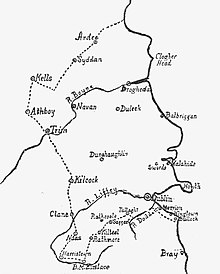
The Pale According to the Statute of 1488 featuring "Syddan"


Siddan ( Irish: An Sián – fairy mound) is a civil parish in County Meath, Ireland. [1] [2]
The parish formerly formed one of the gateways that made up the border of the Pale.
References
- ^ Townlands in Siddan
- ^ "An Sián/Siddan". logainm.ie. Retrieved 24 August 2022.
53°48′N 6°37′W / 53.800°N 6.617°W

|
| This article related to the geography of County Meath, Ireland is a stub. You can help Wikipedia by expanding it. |
Siddan ( Irish: An Sián – fairy mound) is a civil parish in County Meath, Ireland. [1] [2]
The parish formerly formed one of the gateways that made up the border of the Pale.
References
- ^ Townlands in Siddan
- ^ "An Sián/Siddan". logainm.ie. Retrieved 24 August 2022.
53°48′N 6°37′W / 53.800°N 6.617°W
|
| This article related to the geography of County Meath, Ireland is a stub. You can help Wikipedia by expanding it. |