Wrocław Valley
Pradolina Wrocławska | |
|---|---|
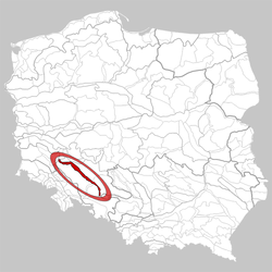
 Location of the Wrocław Valley in Poland | |
| Country | Poland |
| Area | |
| • Total | 1,220 km2 (470 sq mi) |
Wrocław Valley (Pradolina Wrocławska, Polish) ( 318.52) is a mesoregion of great length, located in the Silesian Lowlands, with a total west-to-east length of 100 km, and a width of 10-12 km, totalling a surface area of 1220 km2. From the north and the north-east, the mesoregion borders the Rościsławska Upland, Oleśnica Plain and the Opole Plain, from the north-west with the Wrocław Plain, the Nysa Kłodzka Valley and Niemodlin Plain. On the very north-western tip, the Wrocław Valley borders the Ścinawski Lowland, Lubin Upland and Legnica Plain, whilst on the north-easternmost tip, it borders the Chełm Upland ( Silesian Highlands), and Racibórz Basin. [1]
In geological terms, the Wrocław Valley is part of the Silesia-Kraków Monocline and the Sudetes Foreland Monocline, covered in Pleistocene and Holocene geological material, mainly sand, gravel and fluvisols. [2]
The left tributaries of the River Odra in the mesoregion are: Osobłoga, Nysa Kłodzka, Oława, Ślęza, Bystrzyca, Kaczawa; and right: Mała Panew, Stobrawa and Widawa.
Larger settlements located on the Wrocław Valley are: Krapkowice, Opole, Brzeg, Oława, Wrocław, Brzeg Dolny, and Prochowice.
References
- ^ "Wrocławska Pradolina - WIEM, darmowa encyklopedia". portalwiedzy.onet.pl. Archived from the original on 21 August 2017. Retrieved 21 August 2017.
- ^ "Wrocławska, Pradolina - Encyklopedia PWN - źródło wiarygodnej i rzetelnej wiedzy". encyklopedia.pwn.pl (in Polish). Retrieved 21 August 2017.
Wrocław Valley
Pradolina Wrocławska | |
|---|---|
 Location of the Wrocław Valley in Poland | |
| Country | Poland |
| Area | |
| • Total | 1,220 km2 (470 sq mi) |
Wrocław Valley (Pradolina Wrocławska, Polish) ( 318.52) is a mesoregion of great length, located in the Silesian Lowlands, with a total west-to-east length of 100 km, and a width of 10-12 km, totalling a surface area of 1220 km2. From the north and the north-east, the mesoregion borders the Rościsławska Upland, Oleśnica Plain and the Opole Plain, from the north-west with the Wrocław Plain, the Nysa Kłodzka Valley and Niemodlin Plain. On the very north-western tip, the Wrocław Valley borders the Ścinawski Lowland, Lubin Upland and Legnica Plain, whilst on the north-easternmost tip, it borders the Chełm Upland ( Silesian Highlands), and Racibórz Basin. [1]
In geological terms, the Wrocław Valley is part of the Silesia-Kraków Monocline and the Sudetes Foreland Monocline, covered in Pleistocene and Holocene geological material, mainly sand, gravel and fluvisols. [2]
The left tributaries of the River Odra in the mesoregion are: Osobłoga, Nysa Kłodzka, Oława, Ślęza, Bystrzyca, Kaczawa; and right: Mała Panew, Stobrawa and Widawa.
Larger settlements located on the Wrocław Valley are: Krapkowice, Opole, Brzeg, Oława, Wrocław, Brzeg Dolny, and Prochowice.
References
- ^ "Wrocławska Pradolina - WIEM, darmowa encyklopedia". portalwiedzy.onet.pl. Archived from the original on 21 August 2017. Retrieved 21 August 2017.
- ^ "Wrocławska, Pradolina - Encyklopedia PWN - źródło wiarygodnej i rzetelnej wiedzy". encyklopedia.pwn.pl (in Polish). Retrieved 21 August 2017.