Photos • Location
| Mała Panew | |
|---|---|
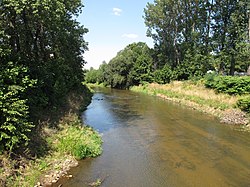
 The Mała Panew near
Ozimek | |
| Location | |
| Country | Poland |
| Physical characteristics | |
| Mouth | |
• location | Oder |
• coordinates | 50°43′06″N 17°52′38″E / 50.71833°N 17.87722°E |
| Basin features | |
| Progression | Oder→ Baltic Sea |
The Mała Panew ( German: Malapane) is a river in south-western Poland, Silesian and Opole Voivodeships. It is a right tributary of the Oder, merging with the Oder near the village of Czarnowąsy near Opole. The Bziniczka is a tributary to the Mala Panew. [1]
The length of the Mała Panew is 132 km; [2] the area of the watershed is 2132 km2.
References
- ^ "Elektroniczny słownik hydronimów Polski | Instytut Języka Polskiego PAN". eshp.ijp.pan.pl. Retrieved 2023-01-06.
- ^ "Mała Panew". Internetowa encyklopedia PWN.
| Mała Panew | |
|---|---|
 The Mała Panew near
Ozimek | |
| Location | |
| Country | Poland |
| Physical characteristics | |
| Mouth | |
• location | Oder |
• coordinates | 50°43′06″N 17°52′38″E / 50.71833°N 17.87722°E |
| Basin features | |
| Progression | Oder→ Baltic Sea |
The Mała Panew ( German: Malapane) is a river in south-western Poland, Silesian and Opole Voivodeships. It is a right tributary of the Oder, merging with the Oder near the village of Czarnowąsy near Opole. The Bziniczka is a tributary to the Mala Panew. [1]
The length of the Mała Panew is 132 km; [2] the area of the watershed is 2132 km2.
References
- ^ "Elektroniczny słownik hydronimów Polski | Instytut Języka Polskiego PAN". eshp.ijp.pan.pl. Retrieved 2023-01-06.
- ^ "Mała Panew". Internetowa encyklopedia PWN.
