| Vorotnavank Որոտնավանք | |
|---|---|
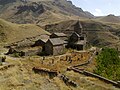
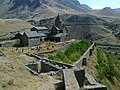
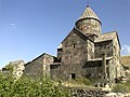
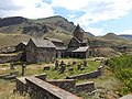
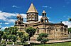
 The monastic complex of Vorotnavank. | |
| Religion | |
| Affiliation | Armenian Apostolic Church |
| Location | |
| Location | On a promontory overlooking the Vorotan gorge, between the villages of
Vaghatin and
Vorotan,
Syunik Province, |
 Shown within Armenia  Vorotnavank (Syunik Province) | |
| Geographic coordinates | 39°29′44″N 46°07′20″E / 39.4956°N 46.1222°E |
| Architecture | |
| Style | Armenian |
| Completed | In use from the 10th-15th centuries S. Stepanos c. 1000 S. Karapet c. 1007 |
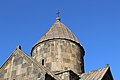
| Dome(s) | 1 (rebuilt after its collapse in the 1931 earthquake) |
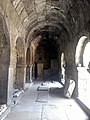
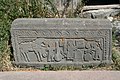
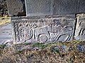
Vorotnavank ( Armenian: Որոտնավանք) is a monastic complex located along a ridge overlooking the Vorotan gorge, between the villages of Vaghatin and Vorotan, about 14 km east of Sisian in the Syunik Province of Armenia. The complex is surrounded by a high stone wall for defense against foreign invasions and once housed workshops, stores, a seminary, resort, cemetery and an alms-house. A pillar stood in the yard of the monastery symbolizing that there were monks entering into religious service and kings inaugurated at this location. Hovhan Vorotnetsi (1315-1398), an Armenian medieval philosopher and theologian as well as the founder of Tatev Vardapetaran University lived and worked at the monastery.
Architecture
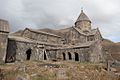
Surp Stepanos Church
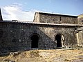
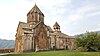
The main church of Surp Stepanos was built in 1000 by Queen Shahandukht, ruler of the lands of Syunik. Prior to the construction of the church stood a shrine to Saint Grigor Lusavorich. Four sacristies were placed at the southeastern end of S. Stepanos.
Surp Karapet Church
The adjoining church of Surp Karapet was constructed in 1006-1007 by Queen Shahandukht's son Sevada. The structure has a triple-arched portico at the front façade. A circular drum and a recently reconstructed dome rest above the cruciform plan of the church.
Destruction
Vorotnavank was destroyed multiple times by foreign invasions as well as an earthquake in 1931 during which S. Karapet's dome collapsed. In 1104 Seljuk-Turks attacked the monastery and the nearby fortress of Vorotnaberd (3 km southeast). Ivane Zakaryan liberated them and gave control of Vorotnavank and Vorotnaberd to Liparit Orbelian of the Orbelyan family. The monastery was repaired and made funcionable during this time. Other foreign invasions included the Mongol-Tatars (1236?) and later Timur Lenk in 1386. An underground passageway was connected to the fortress of Vorotnaberd, and was used during sieges by invading armies. Reconstruction efforts have been underway since 1980 and are nearly complete.
Gallery
-
-
-

-
-

-

-
-
-

-
-
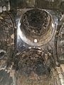
 Interior of the apse at Vorotnavank.
 -
-
-
 Vorotnavank with monastery wall, monastery garden and old cemetery
 -
-

-
-
-

-
-


References
Bibliography
- Arzruni, Şahan (September 2019). "Vorodnavank Manastırı". Paros (96): 86–87.
- Kiesling, Brady (June 2000). Rediscovering Armenia: An Archaeological/Touristic Gazetteer and Map Set for the Historical Monuments of Armenia (PDF). Archived (PDF) from the original on 6 November 2021.
- Kiesling, Brady (2005), Rediscovering Armenia: Guide, Yerevan, Armenia: Matit Graphic Design Studio
External links


| Vorotnavank Որոտնավանք | |
|---|---|
|
The monastic complex of Vorotnavank. | |
| Religion | |
| Affiliation | Armenian Apostolic Church |
| Location | |
| Location | On a promontory overlooking the Vorotan gorge, between the villages of
Vaghatin and
Vorotan,
Syunik Province, |
Shown within Armenia Vorotnavank (Syunik Province) | |
| Geographic coordinates | 39°29′44″N 46°07′20″E / 39.4956°N 46.1222°E |
| Architecture | |
| Style | Armenian |
| Completed | In use from the 10th-15th centuries S. Stepanos c. 1000 S. Karapet c. 1007 |
| Dome(s) | 1 (rebuilt after its collapse in the 1931 earthquake) |
Vorotnavank ( Armenian: Որոտնավանք) is a monastic complex located along a ridge overlooking the Vorotan gorge, between the villages of Vaghatin and Vorotan, about 14 km east of Sisian in the Syunik Province of Armenia. The complex is surrounded by a high stone wall for defense against foreign invasions and once housed workshops, stores, a seminary, resort, cemetery and an alms-house. A pillar stood in the yard of the monastery symbolizing that there were monks entering into religious service and kings inaugurated at this location. Hovhan Vorotnetsi (1315-1398), an Armenian medieval philosopher and theologian as well as the founder of Tatev Vardapetaran University lived and worked at the monastery.
Architecture
Surp Stepanos Church
The main church of Surp Stepanos was built in 1000 by Queen Shahandukht, ruler of the lands of Syunik. Prior to the construction of the church stood a shrine to Saint Grigor Lusavorich. Four sacristies were placed at the southeastern end of S. Stepanos.
Surp Karapet Church
The adjoining church of Surp Karapet was constructed in 1006-1007 by Queen Shahandukht's son Sevada. The structure has a triple-arched portico at the front façade. A circular drum and a recently reconstructed dome rest above the cruciform plan of the church.
Destruction
Vorotnavank was destroyed multiple times by foreign invasions as well as an earthquake in 1931 during which S. Karapet's dome collapsed. In 1104 Seljuk-Turks attacked the monastery and the nearby fortress of Vorotnaberd (3 km southeast). Ivane Zakaryan liberated them and gave control of Vorotnavank and Vorotnaberd to Liparit Orbelian of the Orbelyan family. The monastery was repaired and made funcionable during this time. Other foreign invasions included the Mongol-Tatars (1236?) and later Timur Lenk in 1386. An underground passageway was connected to the fortress of Vorotnaberd, and was used during sieges by invading armies. Reconstruction efforts have been underway since 1980 and are nearly complete.
Gallery
-
-
-
-
-
-
-
-
-
-
-
Interior of the apse at Vorotnavank.
-
-
-
Vorotnavank with monastery wall, monastery garden and old cemetery
-
-
-
-
-
-
-
References
Bibliography
- Arzruni, Şahan (September 2019). "Vorodnavank Manastırı". Paros (96): 86–87.
- Kiesling, Brady (June 2000). Rediscovering Armenia: An Archaeological/Touristic Gazetteer and Map Set for the Historical Monuments of Armenia (PDF). Archived (PDF) from the original on 6 November 2021.
- Kiesling, Brady (2005), Rediscovering Armenia: Guide, Yerevan, Armenia: Matit Graphic Design Studio