| Church of the Red Gospel Կարմիր Ավետարան եկեղեցի | |
|---|---|
.png) Church of the Red Gospel in the early 1900s | |
| Religion | |
| Affiliation | Armenian Apostolic Church |
| Ecclesiastical or organizational status | Cathedral |
| Status | ruined (1989) |
| Location | |
| Location |
Avlabari district, Tbilisi, Georgia |
| Geographic coordinates | 41°41′28″N 44°48′53″E / 41.691014°N 44.814692°E |
| Architecture | |
| Style | Armenian |
| Completed | 1775 |
| Dome height (outer) | 40 meters |
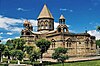
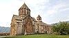
The Church of the Red Gospel ( Armenian: Կարմիր Ավետարան եկեղեցի, Karmir Avetaran Yekeghetsi; Armenian: Կարմիր վանք, Karmir Vank ) or Shamkoretsots Sourb Astvatsatsin Church ( Armenian: Շամքորեցոց Սուրբ Աստվածածին եկեղեցի, meaning Shamkor Inhabitants' Holy Mother of God Church) [1] is a ruined 18th-century Armenian church in the Avlabar district of Old Tbilisi, Tbilisi, Georgia.
It was built in 1735 [2] or 1775 [3] or 1808, [1] and renovated during the 19th century. [2] According to Armenian sources, on April 13, 1989, the church was "blown up" [1] or "destroyed". [4] Georgian officials deny that it was blown up, and ascribed its destruction to the intensity of an earthquake that had struck Tbilisi a day before. [5] At 40 meters, it was the tallest Armenian church in Tbilisi. Today it stands in ruins, with its cupola gone.
Gallery
-
 View of the church in historic Tbilisi
 -
 The ruins of the church after 1989
 -
 Location of the church (upper right) within the Avlabari district
 -
 Closeup of the ruins
 -
 View of the ruins (top center right) from Narikala fortress
 -
 The ruins in 2016
,_in_the_early_1900s,_Sergei_Mikhailovich_Prokudin-Gorskii.jpg)


See also
- Armenian churches of Tbilisi
- Ejmiatsin Church, a nearby Armenian church
- Armenians in Georgia
References
- ^ a b c "Shamkoretsots (Shamkor Inhabitants') Sourb Astvatzatzin (Holy Virgin) Church". Research on Armenian Architecture. Retrieved 8 July 2009.
- ^ a b Thierry, Jean-Michel (1989). Armenian Art. New York: Harry N. Abrams. p. 586. ISBN 0-8109-0625-2.
- ^ Hewsen, Robert H. (2001). Armenia: A Historical Atlas. University of Chicago Press. ISBN 0-226-33228-4.
- ^ Ghazinyan, Aris. "Crisis of Faith: Armenian identity threatened in Tbilisi". ArmeniaNow. Retrieved 14 September 2011.
- ^ "THE CONDITION OF THE ARMENIAN HISTORICAL MONUMENTS IN GEORGIA". Research on Armenian Architecture. Retrieved 8 July 2009.
Bibliography
- Karapetyan, Samvel (1998), The State Policy of Georgia and the Monuments of Armenian Culture (1988-1998) (in Armenian) (1st ed.), Yerevan: Research on Armenian Architecture, pp. IX–XI, ISBN 5-8080-0144-7 (photographic documentation, newspaper articles)
External links
Photos
- Before-and-after photos
- Photos of Karmir Avetaran after the explosion Archived 2011-07-07 at the Wayback Machine
- Another set after the explosion
| Structure | ||
|---|---|---|
| Traditions | ||
| Personalities | Apostles
Saint Thaddeus and
Saint Bartholomew (founders of the Armenian Apostolic Church)
| |
| Councils | ||


Modern Armenian churches and seminaries | ||
|---|---|---|
| Armenia |  | |
| Caucasus | ||
| Russia | ||
| Europe |
| |
| Middle East |
| |
| Asia |
| |
| United States | ||
|
| This article on an Oriental Orthodox place of worship in Georgia is a stub. You can help Wikipedia by expanding it. |
| Church of the Red Gospel Կարմիր Ավետարան եկեղեցի | |
|---|---|
|
Church of the Red Gospel in the early 1900s | |
| Religion | |
| Affiliation | Armenian Apostolic Church |
| Ecclesiastical or organizational status | Cathedral |
| Status | ruined (1989) |
| Location | |
| Location |
Avlabari district, Tbilisi, Georgia |
| Geographic coordinates | 41°41′28″N 44°48′53″E / 41.691014°N 44.814692°E |
| Architecture | |
| Style | Armenian |
| Completed | 1775 |
| Dome height (outer) | 40 meters |
The Church of the Red Gospel ( Armenian: Կարմիր Ավետարան եկեղեցի, Karmir Avetaran Yekeghetsi; Armenian: Կարմիր վանք, Karmir Vank ) or Shamkoretsots Sourb Astvatsatsin Church ( Armenian: Շամքորեցոց Սուրբ Աստվածածին եկեղեցի, meaning Shamkor Inhabitants' Holy Mother of God Church) [1] is a ruined 18th-century Armenian church in the Avlabar district of Old Tbilisi, Tbilisi, Georgia.
It was built in 1735 [2] or 1775 [3] or 1808, [1] and renovated during the 19th century. [2] According to Armenian sources, on April 13, 1989, the church was "blown up" [1] or "destroyed". [4] Georgian officials deny that it was blown up, and ascribed its destruction to the intensity of an earthquake that had struck Tbilisi a day before. [5] At 40 meters, it was the tallest Armenian church in Tbilisi. Today it stands in ruins, with its cupola gone.
Gallery
-
View of the church in historic Tbilisi
-
The ruins of the church after 1989
-
Location of the church (upper right) within the Avlabari district
-
Closeup of the ruins
-
View of the ruins (top center right) from Narikala fortress
-
The ruins in 2016
See also
- Armenian churches of Tbilisi
- Ejmiatsin Church, a nearby Armenian church
- Armenians in Georgia
References
- ^ a b c "Shamkoretsots (Shamkor Inhabitants') Sourb Astvatzatzin (Holy Virgin) Church". Research on Armenian Architecture. Retrieved 8 July 2009.
- ^ a b Thierry, Jean-Michel (1989). Armenian Art. New York: Harry N. Abrams. p. 586. ISBN 0-8109-0625-2.
- ^ Hewsen, Robert H. (2001). Armenia: A Historical Atlas. University of Chicago Press. ISBN 0-226-33228-4.
- ^ Ghazinyan, Aris. "Crisis of Faith: Armenian identity threatened in Tbilisi". ArmeniaNow. Retrieved 14 September 2011.
- ^ "THE CONDITION OF THE ARMENIAN HISTORICAL MONUMENTS IN GEORGIA". Research on Armenian Architecture. Retrieved 8 July 2009.
Bibliography
- Karapetyan, Samvel (1998), The State Policy of Georgia and the Monuments of Armenian Culture (1988-1998) (in Armenian) (1st ed.), Yerevan: Research on Armenian Architecture, pp. IX–XI, ISBN 5-8080-0144-7 (photographic documentation, newspaper articles)
External links
Photos
- Before-and-after photos
- Photos of Karmir Avetaran after the explosion Archived 2011-07-07 at the Wayback Machine
- Another set after the explosion
| Structure | ||
|---|---|---|
| Traditions | ||
| Personalities | Apostles
Saint Thaddeus and
Saint Bartholomew (founders of the Armenian Apostolic Church)
| |
| Councils | ||
Modern Armenian churches and seminaries | ||
|---|---|---|
| Armenia | | |
| Caucasus | ||
| Russia | ||
| Europe |
| |
| Middle East |
| |
| Asia |
| |
| United States | ||
|
| This article on an Oriental Orthodox place of worship in Georgia is a stub. You can help Wikipedia by expanding it. |