


.png)


.jpg)


.jpg)

.jpg)

.jpg)

-

-
 Map of Piraeus, designed according to the Hippodameian grid plan
 -
![The city hall in George Town, Malaysia, serves as the seat of Penang Island City Council.[310]](https://upload.wikimedia.org/wikipedia/commons/thumb/6/6f/Penang_City_Hall.jpg/200px-Penang_City_Hall.jpg)
-
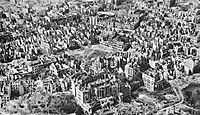 Warsaw Old Town after the Warsaw uprising with 85% of the city destroyed File:Warsaw Old Town 1945.jpg
- Geography
| Part of a series on |
| Geography |
|---|
 |
Geography (from Ancient Greek γεωγραφία geōgraphía; combining gê 'Earth' and gráphō 'write') is the study of the lands, features, inhabitants, and phenomena of Earth. [1] Geography is an all-encompassing discipline that seeks an understanding of Earth and its human and natural complexities—not merely where objects are, but also how they have changed and come to be. While geography is specific to Earth, many concepts can be applied more broadly to other celestial bodies in the field of planetary science. [2] Geography has been called "a bridge between natural science and social science disciplines." [3]
Origins of many of the concepts in geography can be traced to Greek Eratosthenes of Cyrene, who may have coined the term "geographia" ( c. 276 BC – c. 195/194 BC). [4] The first recorded use of the word γεωγραφία was as the title of a book by Greek scholar Claudius Ptolemy (100 – 170 AD). [1] This work created the so called "Ptolemaic tradition" of geography, which included "Ptolemaic cartographic theory." [5] However, the concepts of geography (such as cartography) date back to the earliest attempts to understand the world spatially, with the earliest example of an attempted world map dating to the 9th century BCE in ancient Babylon. [6] The history of geography as a discipline spans cultures and millennia, being independently developed by multiple groups, and cross-pollinated by trade between these groups. The core concepts of geography consistent between all approaches are a focus on space, place, time, and scale. [7] [8] [9] [10] [11] [12]
Today, geography is an extremely broad discipline with multiple approaches and modalities. There have been multiple attempts to organize the discipline, including the four traditions of geography, and into branches. [13] [3] [14] Techniques employed can generally be broken down into quantitative [15] and qualitative [16] approaches, with many studies taking mixed-methods approaches. [17] Common techniques include cartography, remote sensing, interviews, and surveying.
Fundamentals

.svg)
Geography is a systematic study of the Earth (other celestial bodies are specified, such as "geography of Mars", or given another name, such as areography in the case of Mars), its features, and phenomena that take place on it. [18] [19] [20] For something to fall into the domain of geography, it generally needs some sort of spatial component that can be placed on a map, such as coordinates, place names, or addresses. This has led to geography being associated with cartography and place names. Although many geographers are trained in toponymy and cartology, this is not their main preoccupation. Geographers study the Earth's spatial and temporal distribution of phenomena, processes, and features as well as the interaction of humans and their environment. [21] Because space and place affect a variety of topics, such as economics, health, climate, plants, and animals, geography is highly interdisciplinary. The interdisciplinary nature of the geographical approach depends on an attentiveness to the relationship between physical and human phenomena and their spatial patterns. [22]
Names of places...are not geography...To know by heart a whole gazetteer full of them would not, in itself, constitute anyone a geographer. Geography has higher aims than this: it seeks to classify phenomena (alike of the natural and of the political world, in so far as it treats of the latter), to compare, to generalize, to ascend from effects to causes, and, in doing so, to trace out the laws of nature and to mark their influences upon man. This is 'a description of the world'—that is Geography. In a word, Geography is a Science—a thing not of mere names but of argument and reason, of cause and effect. [23]
— William Hughes, 1863
Geography as a discipline can be split broadly into three main branches: human geography, physical geography, and technical geography. [3] [24] Human geography largely focuses on the built environment and how humans create, view, manage, and influence space. [24] Physical geography examines the natural environment and how organisms, climate, soil, water, and landforms produce and interact. [25] The difference between these approaches led to the development of integrated geography, which combines physical and human geography and concerns the interactions between the environment and humans. [21] Technical geography involves studying and developing the tools and techniques used by geographers, such as remote sensing, cartography, and geographic information system. [26]
Key concepts
Narrowing down geography to a few key concepts is extremely challenging, and subject to tremendous debate within the discipline. [27] In one attempt, the 1st edition of the book "Key Concepts in Geography" broke down this into chapters focusing on "Space," "Place," "Time," "Scale," and "Landscape." [28] The 2nd edition of the book expanded on these key concepts by adding "Environmental systems," "Social Systems," "Nature," " Globalization," "Development," and "Risk," demonstrating how challenging narrowing the field can be. [27]

Another approach used extensively in teaching geography are the Five themes of geography established by "Guidelines for Geographic Education: Elementary and Secondary Schools," published jointly by the National Council for Geographic Education and the Association of American Geographers in 1984. [29] [30] These themes are Location, place, relationships within places (often summarized as Human-Environment Interaction), movement, and regions [30] [31] The five themes of geography have shaped how American education approaches the topic in the years since. [30] [31]
Space

Just as all phenomena exist in time and thus have a history, they also exist in space and have a geography. [32]
For something to exist in the realm of geography, it must be able to be described spatially. [32] [33] Thus, space is the most fundamental concept at the foundation of geography. [7] [8] The concept is so basic, that geographers often have difficulty defining exactly what it is. Absolute space is the exact site, or spatial coordinates, of objects, persons, places, or phenomena under investigation. [7] We exist in space. [9] Absolute space leads to the view of the world as a photograph, with everything frozen in place when the coordinates were recorded. Today, geographers are trained to recognize the world as a dynamic space where all processes interact and take place, rather than a static image on a map. [7] [34]
Place
Place is one of the most complex and important terms in geography. [9] [10] [11] [12] In human geography, place is the synthesis of the coordinates on the Earth's surface, the activity and use that occurs, has occurred, and will occur at the coordinates, and the meaning ascribed to the space by human individuals and groups. [33] [11] This can be extraordinarily complex, as different spaces may have different uses at different times and mean different things to different people. In physical geography, a place includes all of the physical phenomena that occur in space, including the lithosphere, atmosphere, hydrosphere, and biosphere. [12] Places do not exist in a vacuum and instead have complex spatial relationships with each other, and place is concerned how a location is situated in relation to all other locations. [35] [36] As a discipline then, the term place in geography includes all spatial phenomena occurring at a location, the diverse uses and meanings humans ascribe to that location, and how that location impacts and is impacted by all other locations on Earth. [11] [12] In one of Yi-Fu Tuan's papers, he explains that in his view, geography is the study of Earth as a home for humanity, and thus place and the complex meaning behind the term is central to the discipline of geography. [10]
Time

Time is usually thought to be within the domain of history, however, it is of significant concern in the discipline of geography. [37] [38] [39] In physics, space and time are not separated, and are combined into the concept of spacetime. [40] Geography is subject to the laws of physics, and in studying things that occur in space, time must be considered. Time in geography is more than just the historical record of events that occurred at various discrete coordinates; but also includes modeling the dynamic movement of people, organisms, and things through space. [9] Time facilitates movement through space, ultimately allowing things to flow through a system. [37] The amount of time an individual, or group of people, spends in a place will often shape their attachment and perspective to that place. [9] Time constrains the possible paths that can be taken through space, given a starting point, possible routes, and rate of travel. [41] Visualizing time over space is challenging in terms of cartography, and includes Space-Prism, advanced 3D geovisualizations, and animated maps. [35] [41] [42] [34]
Scale

Scale in the context of a map is the ratio between a distance measured on the map and the corresponding distance as measured on the ground. [2] [43] This concept is fundamental to the discipline of geography, not just cartography, in that phenomena being investigated appear different depending on the scale used. [44] [45] Scale is the frame that geographers use to measure space, and ultimately to try and understand a place. [43]
Laws of geography
During the quantitative revolution, geography shifted to an empirical law-making ( nomothetic) approach. [46] [47] Several laws of geography have been proposed since then, most notably by Waldo Tobler and can be viewed as a product of the quantitative revolution. [48] In general, some dispute the entire concept of laws in geography and the social sciences. [35] [49] [50] These criticisms have been addressed by Tobler and others, such as Michael Frank Goodchild. [49] [50] However, this is an ongoing source of debate in geography and is unlikely to be resolved anytime soon. Several laws have been proposed, and Tobler's first law of geography is the most generally accepted in geography. Some have argued that geographic laws do not need to be numbered. The existence of a first invites a second, and many have proposed themselves as that. It has also been proposed that Tobler's first law of geography should be moved to the second and replaced with another. [50] A few of the proposed laws of geography are below:
- Tobler's first law of geography: "Everything is related to everything else, but near things are more related than distant" [35] [49] [50]
- Tobler's second law of geography: "The phenomenon external to a geographic area of interest affects what goes on inside." [49] [51]
- Arbia's law of geography: "Everything is related to everything else, but things observed at a coarse spatial resolution are more related than things observed at a finer resolution." [44] [49] [45] [52] [53]
- Spatial heterogeneity: Geographic variables exhibit uncontrolled variance. [50] [54] [55]
- The uncertainty principle: "That the geographic world is infinitely complex and that any representation must therefore contain elements of uncertainty, that many definitions used in acquiring geographic data contain elements of vagueness, and that it is impossible to measure location on the Earth's surface exactly." [50]
Additionally, several variations or amendments to these laws exist within the literature, although not as well supported. For example, one paper proposed an amendmended version of Tobler's first law of geography, referred to in the text as the Tobler–von Thünen law, [48] which states: "Everything is related to everything else, but near things are more related than distant things, as a consequence of accessibility." [Note 1] [48]
Sub-disciplines
Geography is a branch of inquiry that focuses on spatial information on Earth. It is an extremely broad topic and can be broken down multiple ways. [14] There have been several approaches to doing this spanning at least several centuries, including "four traditions of geography" and into distinct branches. [56] [13] The Four traditions of geography are often used to divide the different historical approaches theories geographers have taken to the discipline. [13] In contrast, geography's branches describe contemporary applied geographical approaches. [3]
Four traditions of geography
Geography is an extremely broad field. Because of this, many view the various definitions of geography proposed over the decades as inadequate. To address this, William D. Pattison proposed the concept of the "Four traditions of Geography" in 1964. [13] [57] [58] These traditions are the Spatial or Locational Tradition, the Man-Land or Human-Environment Interaction Tradition (sometimes referred to as Integrated geography), the Area Studies or Regional Tradition, and the Earth Science Tradition. [13] [57] [58] These concepts are broad sets of geography philosophies bound together within the discipline. They are one of many ways geographers organize the major sets of thoughts and philosophies within the discipline. [13] [57] [58]
Branches of geography
In another approach to the abovementioned four traditions, geography is organized into applied branches. [59] [60] The UNESCO Encyclopedia of Life Support Systems organizes geography into the three categories of human geography, physical geography, and technical geography. [3] [61] [59] [14] Some publications limit the number of branches to physical and human, describing them as the principal branches. [33] Geographers rarely focus on just one of these topics, often using one as their primary focus and then incorporating data and methods from the other branches. Often, geographers are asked to describe what they do by individuals outside the discipline [10] and are likely to identify closely with a specific branch, or sub-branch when describing themselves to lay people. Human geography studies people and their communities, cultures, economies, and environmental interactions by studying their relations with and across space and place. [33] Physical geography is concerned with the study of processes and patterns in the natural environment like the atmosphere, hydrosphere, biosphere, and geosphere. [33] Technical geography is interested in studying and applying techniques and methods to store, process, analyze, visualize, and use spatial data. [60] It is the newest of the branches, the most controversial, and often other terms are used in the literature to describe the emerging category. These branches use similar geographic philosophies, concepts, and tools and often overlap significantly.
Physical
Physical geography (or physiography) focuses on geography as an Earth science. [62] [63] [64] It aims to understand the physical problems and the issues of lithosphere, hydrosphere, atmosphere, pedosphere, and global flora and fauna patterns ( biosphere). Physical geography is the study of earth's seasons, climate, atmosphere, soil, streams, landforms, and oceans. [65] Physical geographers will often work in identifying and monitoring the use of natural resources.
- Physical geography can be divided into many broad categories, including:
-
-
-

-

-

-
-
 Hydrology and hydrography
 -

-

-

-
-
Human
Human geography (or anthropogeography) is a branch of geography that focuses on studying patterns and processes that shape human society. [66] It encompasses the human, political, cultural, social, and economic aspects. In industry, human geographers often work in city planning, public health, or business analysis.
- Human geography can be divided into many broad categories, such as:
-

-

-
-

-

-
-

-
-
-

-

-
-
-
Various approaches to the study of human geography have also arisen through time and include:
Technical
Technical geography concerns studying and developing tools, techniques, and statistical methods employed to collect, analyze, use, and understand spatial data. [26] [3] [59] [61] Technical geography is the most recently recognized, and controversial, of the branches. Its use dates back to 1749, when a book published by Edward Cave organized the discipline into a section containing content such as cartographic techniques and globes. [56] There are several other terms, often used interchangeably with technical geography to subdivide the discipline, including "techniques of geographic analysis," [67] "Geographic Information Technology," [1] "Geography method's and techniques," [68] " Geographic Information Science," [69] " geoinformatics," " geomatics," and "information geography". There are subtle differences to each concept and term; however, technical geography is one of the broadest, is consistent with the naming convention of the other two branches, has been in use since the 1700s, and has been used by the UNESCO Encyclopedia of Life Support Systems to divide geography into themes. [3] [59] [56] As academic fields increasingly specialize in their nature, technical geography has emerged as a branch of geography specializing in geographic methods and thought. [26] The emergence of technical geography has brought new relevance to the broad discipline of geography by serving as a set of unique methods for managing the interdisciplinary nature of the phenomena under investigation. While human and physical geographers use the techniques employed by technical geographers, technical geography is more concerned with the fundamental spatial concepts and technologies than the nature of the data. [26] [60] It is therefore closely associated with the spatial tradition of geography while being applied to the other two major branches. A technical geographer might work as a GIS analyst, a GIS developer working to make new software tools, or create general reference maps incorporating human and natural features. [70]
- Technical geography can be divided into many broad categories, such as:
-

-

-
-
-

-

-

-
-

-

Methods
This section needs additional citations for
verification. (August 2022) |
All geographic research and analysis start with asking the question "where," followed by "why there." Geographers start with the fundamental assumption set forth in Tobler's first law of geography, that "everything is related to everything else, but near things are more related than distant things." [35] [36] As spatial interrelationships are key to this synoptic science, maps are a key tool. Classical cartography has been joined by a more modern approach to geographical analysis, computer-based geographic information systems (GIS).
In their study, geographers use four interrelated approaches:
- Analytical – Asks why we find features and populations in a specific geographic area.
- Descriptive – Simply specifies the locations of features and populations.
- Regional – Examines systematic relationships between categories for a specific region or location on the planet.
- Systematic – Groups geographical knowledge into categories that can be explored globally.
Quantitative methods

Quantitative methods in geography became particularly influential in the discipline during the quantitative revolution of the 1950s and 60s. [15] These methods revitalized the discipline in many ways, allowing scientific testing of hypotheses and proposing scientific geographic theories and laws. [71] The quantitative revolution heavily influenced and revitalized technical geography, and lead to the development of the subfield of quantitative geography. [26] [15]
Quantitative cartography
Cartography is the art, science, and technology of making maps. [72] Cartographers study the Earth's surface representation with abstract symbols (map making). Although other subdisciplines of geography rely on maps for presenting their analyses, the actual making of maps is abstract enough to be regarded separately. [73] Cartography has grown from a collection of drafting techniques into an actual science.
Cartographers must learn cognitive psychology and ergonomics to understand which symbols convey information about the Earth most effectively and behavioural psychology to induce the readers of their maps to act on the information. They must learn geodesy and fairly advanced mathematics to understand how the shape of the Earth affects the distortion of map symbols projected onto a flat surface for viewing. It can be said, without much controversy, that cartography is the seed from which the larger field of geography grew.
Geographic information systems
Geographic information systems (GIS) deal with storing information about the Earth for automatic retrieval by a computer in an accurate manner appropriate to the information's purpose. [74] In addition to all of the other subdisciplines of geography, GIS specialists must understand computer science and database systems. GIS has revolutionized the field of cartography: nearly all mapmaking is now done with the assistance of some form of GIS software. The science of using GIS software and GIS techniques to represent, analyse, and predict the spatial relationships is called geographic information science (GISc). [75]
Remote sensing

Remote sensing is the art, science, and technology of obtaining information about Earth's features from measurements made at a distance. [76] Remotely sensed data can be either passive, such as traditional photography, or active, such as LiDAR. [76] A variety of platforms can be used for remote sensing, including satellite imagery, aerial photography (including consumer drones), and data obtained from hand-held sensors. [76] Products from remote sensing include Digital elevation model and cartographic base maps. Geographers increasingly use remotely sensed data to obtain information about the Earth's land surface, ocean, and atmosphere, because it: (a) supplies objective information at a variety of spatial scales (local to global), (b) provides a synoptic view of the area of interest, (c) allows access to distant and inaccessible sites, (d) provides spectral information outside the visible portion of the electromagnetic spectrum, and (e) facilitates studies of how features/areas change over time. Remotely sensed data may be analyzed independently or in conjunction with other digital data layers (e.g., in a geographic information system). Remote sensing aids in land use, land cover (LULC) mapping, by helping to determine both what is naturally occurring on a piece of land and what human activities are taking place on it. [77]
Geostatistics
Geostatistics deal with quantitative data analysis, specifically the application of a statistical methodology to the exploration of geographic phenomena. [78] Geostatistics is used extensively in a variety of fields, including hydrology, geology, petroleum exploration, weather analysis, urban planning, logistics, and epidemiology. The mathematical basis for geostatistics derives from cluster analysis, linear discriminant analysis and non-parametric statistical tests, and a variety of other subjects. Applications of geostatistics rely heavily on geographic information systems, particularly for the interpolation (estimate) of unmeasured points. Geographers are making notable contributions to the method of quantitative techniques.
Qualitative methods
Qualitative methods geography in geography are descriptive rather than numerical or statistical in nature. [79] [16] [46] They add context to concepts, and explore human concepts like beliefs and perspective that are difficult or impossible to quantify. [16] Human geography is much more likely to employ qualitative methods than physical. Increasingly, technical geographers are attempting to employ GIS methods to qualitative datasets. [16] [80]
Qualitative cartography

Qualitative cartography employs many of the same software and techniques as quantitative. [80] It may be employed to inform on map practices, or to visualize perspectives and ideas that are not strictly quantitative in nature. [80] [16] An example of a form of qualitative cartography is a Chorochromatic map of nominal data, such as land cover or dominant language group in an area. [81] Another example is a deep map, or maps that combine geography and storytelling to produce a product with greater information than a two-dimensional image of places, names, and topography. [82] [83] This approach offers more inclusive strategies than more traditional cartographic approaches for connecting the complex layers that makeup places. [83]
Ethnography
Ethnographical research techniques are used by human geographers. [84] In cultural geography, there is a tradition of employing qualitative research techniques, also used in anthropology and sociology. Participant observation and in-depth interviews provide human geographers with qualitative data.
Geopoetics
Geopoetics is an interdisciplinary approach that combines geography and poetry to explore the interconnectedness between humans, space, place, and the environment. [85] [86] Geopoetics is employed as a mixed methods tool to explain the implications of geographic research. [87] It is often employed to address and communicate the implications of complex topics, such as the anthropocene. [88] [89] [90] [91] [92]
Interviews
Geographers employ interviews to gather data and acquire valuable understandings from individuals or groups regarding their encounters, outlooks, and opinions concerning spatial phenomena. [93] [94] Interviews can be carried out through various mediums, including face-to-face interactions, phone conversations, online platforms, or written exchanges. [46] Geographers typically adopt a structured or semi-structured approach during interviews involving specific questions or discussion points when utilized for research purposes. [93] These questions are designed to extract focused information about the research topic while being flexible enough to allow participants to express their experiences and viewpoints, such as through open-ended questions. [93]
History
The concept of geography is present in all cultures, and therefore the history of the discipline is a series of competing narratives, with concepts emerging at various points across space and time. [95] The oldest known world maps date back to ancient Babylon from the 9th century BC. [96] The best known Babylonian world map, however, is the Imago Mundi of 600 BC. [97] The map as reconstructed by Eckhard Unger shows Babylon on the Euphrates, surrounded by a circular landmass showing Assyria, Urartu, and several cities, in turn surrounded by a "bitter river" ( Oceanus), with seven islands arranged around it so as to form a seven-pointed star. [98] The accompanying text mentions seven outer regions beyond the encircling ocean. The descriptions of five of them have survived. [99] In contrast to the Imago Mundi, an earlier Babylonian world map dating back to the 9th century BC depicted Babylon as being further north from the center of the world, though it is not certain what that center was supposed to represent. [96]

The ideas of Anaximander (c. 610–545 BC): considered by later Greek writers to be the true founder of geography, come to us through fragments quoted by his successors. [100] Anaximander is credited with the invention of the gnomon, the simple, yet efficient Greek instrument that allowed the early measurement of latitude. [100] Thales is also credited with the prediction of eclipses. The foundations of geography can be traced to ancient cultures, such as the ancient, medieval, and early modern Chinese. The Greeks, who were the first to explore geography as both art and science, achieved this through Cartography, Philosophy, and Literature, or through Mathematics. There is some debate about who was the first person to assert that the Earth is spherical in shape, with the credit going either to Parmenides or Pythagoras. Anaxagoras was able to demonstrate that the profile of the Earth was circular by explaining eclipses. However, he still believed that the Earth was a flat disk, as did many of his contemporaries. One of the first estimates of the radius of the Earth was made by Eratosthenes. [101]
The first rigorous system of latitude and longitude lines is credited to Hipparchus. He employed a sexagesimal system that was derived from Babylonian mathematics. The meridians were subdivided into 360°, with each degree further subdivided into 60 ( minutes). To measure the longitude at different locations on Earth, he suggested using eclipses to determine the relative difference in time. [102] The extensive mapping by the Romans as they explored new lands would later provide a high level of information for Ptolemy to construct detailed atlases. He extended the work of Hipparchus, using a grid system on his maps and adopting a length of 56.5 miles for a degree. [103]
From the 3rd century onwards, Chinese methods of geographical study and writing of geographical literature became much more comprehensive than what was found in Europe at the time (until the 13th century). [104] Chinese geographers such as Liu An, Pei Xiu, Jia Dan, Shen Kuo, Fan Chengda, Zhou Daguan, and Xu Xiake wrote important treatises, yet by the 17th century advanced ideas and methods of Western-style geography were adopted in China.

During the Middle Ages, the fall of the Roman empire led to a shift in the evolution of geography from Europe to the Islamic world. [104] Muslim geographers such as Muhammad al-Idrisi produced detailed world maps (such as Tabula Rogeriana), while other geographers such as Yaqut al-Hamawi, Abu Rayhan Biruni, Ibn Battuta, and Ibn Khaldun provided detailed accounts of their journeys and the geography of the regions they visited. Turkish geographer Mahmud al-Kashgari drew a world map on a linguistic basis, and later so did Piri Reis ( Piri Reis map). Further, Islamic scholars translated and interpreted the earlier works of the Romans and the Greeks and established the House of Wisdom in Baghdad for this purpose. [105] Abū Zayd al-Balkhī, originally from Balkh, founded the "Balkhī school" of terrestrial mapping in Baghdad. [106] Suhrāb, a late tenth century Muslim geographer accompanied a book of geographical coordinates, with instructions for making a rectangular world map with equirectangular projection or cylindrical equidistant projection. [107]
Abu Rayhan Biruni (976–1048) first described a polar equi- azimuthal equidistant projection of the celestial sphere. [108] He was regarded as the most skilled when it came to mapping cities and measuring the distances between them, which he did for many cities in the Middle East and the Indian subcontinent. He often combined astronomical readings and mathematical equations to develop methods of pin-pointing locations by recording degrees of latitude and longitude. He also developed similar techniques when it came to measuring the heights of mountains, depths of the valleys, and expanse of the horizon. He also discussed human geography and the planetary habitability of the Earth. He also calculated the latitude of Kath, Khwarezm, using the maximum altitude of the Sun, and solved a complex geodesic equation to accurately compute the Earth's circumference, which was close to modern values of the Earth's circumference. [109] His estimate of 6,339.9 km for the Earth radius was only 16.8 km less than the modern value of 6,356.7 km. In contrast to his predecessors, who measured the Earth's circumference by sighting the Sun simultaneously from two different locations, al-Biruni developed a new method of using trigonometric calculations based on the angle between a plain and mountain top, which yielded more accurate measurements of the Earth's circumference, and made it possible for it to be measured by a single person from a single location. [110]
The European Age of Discovery during the 16th and the 17th centuries, where many new lands were discovered and accounts by European explorers such as Christopher Columbus, Marco Polo, and James Cook revived a desire for both accurate geographic detail and more solid theoretical foundations in Europe. The problem facing both explorers and geographers was finding the latitude and longitude of a geographic location. The problem of latitude was solved long ago, but that of longitude remained; agreeing on what zero meridians should be was only part of the problem. It was left to John Harrison to solve it by inventing the chronometer H-4 in 1760, and later in 1884 for the International Meridian Conference to adopt by convention the Greenwich meridian as zero meridians. [109]
The 18th and 19th centuries were the times when geography became recognized as a discrete academic discipline, and became part of a typical university curriculum in Europe (especially Paris and Berlin). The development of many geographic societies also occurred during the 19th century, with the foundations of the Société de Géographie in 1821, the Royal Geographical Society in 1830, Russian Geographical Society in 1845, American Geographical Society in 1851, and the National Geographic Society in 1888. The influence of Immanuel Kant, Alexander von Humboldt, Carl Ritter, and Paul Vidal de la Blache can be seen as a major turning point in geography from philosophy to an academic subject. [111] [112] [113] [114] [115]

Over the past two centuries, the advancements in technology with computers have led to the development of geomatics and new practices such as participant observation and geostatistics being incorporated into geography's portfolio of tools. In the West during the 20th century, the discipline of geography went through four major phases: environmental determinism, regional geography, the quantitative revolution, and critical geography. The strong interdisciplinary links between geography and the sciences of geology and botany, as well as economics, sociology, and demographics, have also grown greatly, especially as a result of earth system science that seeks to understand the world in a holistic view. New concepts and philosophies have emerged from the rapid advancement of computers, quantitative methods, and interdisciplinary approaches. In 1970, Waldo Tobler proposed the first law of geography, "everything is related to everything else, but near things are more related than distant things." [35] [36] This law summarizes the first assumption geographers make about the world.
Notable geographers


- Alexander von Humboldt (1769–1859) – published Cosmos and founder of the sub-field biogeography.
- Anne Kelly Knowles (Born 1957) – influential in the use of GIS and geographic methods in History.
- Carl O. Sauer (1889–1975) – cultural geographer.
- Carl Ritter (1779–1859) – occupied the first chair of geography at Berlin University.
- Cynthia Brewer – cartographic theorist that created the web application ColorBrewer.
- Dana Tomlin – originator of map algebra
- Doreen Massey (1944–2016) – scholar in the space and places of globalization and its pluralities; winner of the Vautrin Lud Prize.
- Ellen Churchill Semple (1863–1932) – first female president of the Association of American Geographers.
- Eratosthenes ( c. 276–c. 195/194 BC) – calculated the size of the Earth.
- Ernest Burgess (1886–1966) – creator of the concentric zone model.
- George F. Jenks (1916-1996) – influential in computer cartography and thematic mapping
- Gerardus Mercator (1512–1594) – cartographer who produced the mercator projection
- Mark Monmonier (born 1943) – cartographic theorist who wrote numerous books contributing to Geographic Information Systems.
- Mei-Po Kwan (born 1962) – contributed significantly to the use of GPS and real-time mapping within GIS
- Michael Frank Goodchild (born 1944) – GIScience scholar and winner of the RGS founder's medal in 2003.
- Muhammad al-Idrisi (Arabic: أبو عبد الله محمد الإدريسي; Latin: Dreses) (1100–1165) – author of Nuzhatul Mushtaq.
- Nigel Thrift (born 1949) – originator of non-representational theory.
- Paul Vidal de La Blache (1845–1918) – founder of the French school of geopolitics, wrote the principles of human geography.
- Ptolemy (c. 100–c. 170) – compiled Greek and Roman knowledge into the book Geographia.
- Roger Tomlinson (1933 – 2014) – the primary originator of modern geographic information systems.
- Sir Halford Mackinder (1861–1947) – co-founder of the LSE, Geographical Association.
- Strabo (64/63 BC – c. AD 24) – wrote Geographica, one of the first books outlining the study of geography.
- Waldo Tobler (1930–2018) – coined the first law of geography and second law of geography.
- Walter Christaller (1893–1969) – human geographer and inventor of Central place theory.
- William Morris Davis (1850–1934) – father of American geography and developer of the cycle of erosion.
- Yi-Fu Tuan (1930–2022) – Chinese-American scholar credited with starting Humanistic Geography as a discipline.
Institutions and societies
- American Association of Geographers (AAG) [116]
- American Geographical Society (US) [117]
- Anton Melik Geographical Institute (Slovenia)
- Gamma Theta Upsilon (international)
- Institute of Geographical Information Systems (Pakistan)
- International Geographical Union (International)
- National Council for Geographic Education (United States)
- National Geographic Society (United States) [118]
- Royal Canadian Geographical Society (Canada)
- Royal Danish Geographical Society (Denmark)
- Royal Geographical Society (UK) [119]
- Russian Geographical Society (Russia)
Publications
- Annals of the American Association of Geographers
- Antipode
- Applied Geography
- Concepts and Techniques in Modern Geography
- Dialogues in Human Geography
- Economic Geography
- Geographia Technica
- Geographical Review
- Geographical Bulletin
- GeoHumanities
- International Journal of Geographical Information Science
- ISPRS International Journal of Geo-Information
- Journal of Maps
- Journal of Rural Studies
- Journal of Transport Geography
- National Geographic
- Professional Geographer
- Progress in Human Geography
- The Geographical Journal
- The Professional Geographer
Related fields
Geology

The discipline of geography, especially physical geography, and geology have significant overlap. In the past, the two have often shared academic departments at universities, a point that has led to conflict over resources. [120] Both disciplines do seek to understand the rocks on the Earth's surface and the processes that change them over time. Geology employs many of the tools and techniques of technical geographers, such as GIS and remote sensing to aid in geological mapping. [121] However, geology includes research that goes beyond the spatial component, such as the chemical analysis of rocks and biogeochemistry. [122]
History
The discipline of History has significant overlap with geography, especially human geography. [123] [124] Like geology, history and geography have shared university departments. Geography provides the spatial context within which historical events unfold. [123] The physical geographic features of a region, such as its landforms, climate, and resources, shape human settlements, trade routes, and economic activities, which in turn influence the course of historical events. [123] Thus, a historian must have a strong foundation in geography. [123] [124] Historians employ the techniques of technical geographers to create historical atlases and maps.
Planetary science

While the discipline of geography is normally concerned with the Earth, the term can also be informally used to describe the study of other worlds, such as the planets of the Solar System and even beyond. The study of systems larger than the Earth itself usually forms part of Astronomy or Cosmology. The study of other planets is usually called planetary science. Alternative terms such as areography (geography of Mars) have been employed to describe the study of other celestial objects. Ultimately, geography may be considered a subdiscipline within planetary science.
See also
- Earth analog – Planet with environment similar to Earth's
- Geologic time scale – System that relates geologic strata to time
- Geophysics – Physics of the Earth and its vicinity
- History of Earth – Development of planet Earth from its formation to the present day
- Terrestrial planet – Planet that is composed primarily of silicate rocks or metals
- Theoretical planetology – Scientific modeling of planets
Notes
- ^ Emphasis added.
References
- ^ a b c Dahlman, Carl; Renwick, William (2014). Introduction to Geography: People, Places & Environment (6th ed.). Pearson. ISBN 978-0137504510.
- ^ a b Burt, Tim (2009). Key Concepts in Geography: Scale, Resolution, Analysis, and Synthesis in Physical Geography (2nd ed.). John Wiley & Sons. pp. 85–96. ISBN 978-1-4051-9146-3.
- ^ a b c d e f g Sala, Maria (2009). Geography Volume I. Oxford, United Kingdom: EOLSS UNESCO. ISBN 978-1-84826-960-6.
- ^ Roller, Duane W. (2010). Eratosthenes' Geography. New Jersey: Princeton University Press. ISBN 9780691142678. Retrieved 29 January 2024.
- ^ Brentjes, Sonja (2009). "Cartography in Islamic Societies". International Encyclopedia of Human Geography. Elsevier. pp. 414–427. ISBN 978-0-08-044911-1. Retrieved 29 January 2024.
- ^ Kurt A. Raaflaub & Richard J. A. Talbert (2009). Geography and Ethnography: Perceptions of the World in Pre-Modern Societies. John Wiley & Sons. p. 147. ISBN 978-1-4051-9146-3.
- ^ a b c d Thrift, Nigel (2009). Key Concepts in Geography: Space, The Fundamental Stuff of Geography (2nd ed.). John Wiley & Sons. pp. 85–96. ISBN 978-1-4051-9146-3.
- ^ a b Kent, Martin (2009). Key Concepts in Geography: Space, Making Room for Space in Physical Geography (2nd ed.). John Wiley & Sons. pp. 97–119. ISBN 978-1-4051-9146-3.
- ^ a b c d e Tuan, Yi-Fu (1977). Space and Place: The Perspective of Experience. University of Minnesota Press. ISBN 0-8166-3877-2.
- ^ a b c d Tuan, Yi-Fu (1991). "A View of Geography". Geographical Review. 81 (1): 99–107. Bibcode: 1991GeoRv..81...99T. doi: 10.2307/215179. JSTOR 215179. Retrieved 5 January 2023.
- ^ a b c d Castree, Noel (2009). Key Concepts in Geography: Place, Connections and Boundaries in an Interdependent World (2nd ed.). John Wiley & Sons. pp. 85–96. ISBN 978-1-4051-9146-3.
- ^ a b c d Gregory, Ken (2009). Key Concepts in Geography: Place, The Management of Sustainable Physical Environments (2nd ed.). John Wiley & Sons. pp. 173–199. ISBN 978-1-4051-9146-3.
- ^ a b c d e f Pattison, William (1964). "The Four Traditions of Geography". Journal of Geography. 63 (5): 211–216. Bibcode: 1964JGeog..63..211P. doi: 10.1080/00221346408985265. Retrieved 27 August 2022.
- ^ a b c Tambassi, Timothy (2021). The Philosophy of Geo-Ontologies (2nd ed.). Springer. ISBN 978-3-030-78144-6.
- ^ a b c Fotheringham, A. Stewart; Brunsdon, Chris; Charlton, Martin (2000). Quantitative Geography: Perspectives on Spatial Data Analysis. Sage Publications Ltd. ISBN 978-0-7619-5948-9.
- ^ a b c d e Burns, Ryan; Skupin, Andre´ (2013). "Towards Qualitative Geovisual Analytics: A Case Study Involving Places, People, and Mediated Experience". Cartographica: The International Journal for Geographic Information and Geovisualization. 48 (3): 157–176. doi: 10.3138/carto.48.3.1691. S2CID 3269642. Retrieved 17 December 2022.
- ^ Diriwächter, R. & Valsiner, J. (January 2006) Qualitative Developmental Research Methods in Their Historical and Epistemological Contexts. FQS. Vol 7, No. 1, Art. 8
- ^ "Areography". Merriam-Webster. Retrieved 27 July 2022.
- ^ Lowell, Percival (April 1902). "Areography". Proceedings of the American Philosophical Society. 41 (170): 225–234. JSTOR 983554. Retrieved 27 July 2022.
- ^ Sheehan, William (19 September 2014). "Geography of Mars, or Areography". Camille Flammarion's the Planet Mars. Astrophysics and Space Science Library. Vol. 409. pp. 435–441. doi: 10.1007/978-3-319-09641-4_7. ISBN 978-3-319-09640-7.
- ^ a b Hayes-Bohanan, James (29 September 2009). "What is Environmental Geography, Anyway?". webhost.bridgew.edu. Bridgewater State University. Archived from the original on 26 October 2006. Retrieved 10 November 2016.
- ^ Hornby, William F.; Jones, Melvyn (29 June 1991). An introduction to Settlement Geography. Cambridge University Press. ISBN 978-0-521-28263-5. Archived from the original on 25 December 2016.
- ^ Hughes, William. (1863). The Study of Geography. Lecture delivered at King's College, London, by Sir Marc Alexander. Quoted in Baker, J.N.L (1963). The History of Geography. Oxford: Basil Blackwell. p. 66. ISBN 978-0-85328-022-4.
- ^ a b Hough, Carole; Izdebska, Daria (2016). "Names and Geography". In Gammeltoft, Peder (ed.). The Oxford Handbook of Names and Naming. Oxford, United Kingdom: Oxford University Press. ISBN 978-0-19-965643-1.
- ^ Cotterill, Peter D. (1997). "What is geography?". AAG Career Guide: Jobs in Geography and related Geographical Sciences. American Association of Geographers. Archived from the original on October 6, 2006. Retrieved October 9, 2006.
- ^ a b c d e Haidu, Ionel (2016). "What is Technical Geography" (PDF). Geographia Technica. 11 (1): 1–5. doi: 10.21163/GT_2016.111.01. Archived (PDF) from the original on 19 January 2022. Retrieved 22 July 2022.
- ^ a b Clifford, Nicholas J.; Holloway, Sarah L.; Rice, Stephen P.; Valentine, Gill, eds. (2014). Key Concepts in Geography (2nd ed.). Sage. ISBN 978-1-4129-3022-2. Retrieved 2 December 2023.
- ^ Holloway, Sarah L.; Rice, Stephen P.; Valentine, Gill, eds. (2003). Key Concepts in Geography (1st ed.). Sage. ISBN 978-0761973898.
- ^ Guidelines for Geographic Education: Elementary and Secondary Schools. The Council. 1984. ISBN 9780892911851.
- ^ a b c Natoli, Salvatore J. (1 January 1994). "Guidelines for Geographic Education and the Fundamental Themes in Geography". Journal of Geography. 93 (1): 2–6. doi: 10.1080/00221349408979676. ISSN 0022-1341.
- ^ a b Buchanan, Lisa Brown; Tschida, Christina M. (2015). "Exploring the five themes of geography using technology". The Ohio Social Studies Review. 52 (1): 29-39.
- ^ a b "Chapter 3: Geography's Perspectives". Rediscovering Geography: New Relevance for Science and Society. Washington, DC: The National Academies Press. 1997. p. 28. doi: 10.17226/4913. ISBN 978-0-309-05199-6. Archived from the original on 2014-05-07. Retrieved 2014-05-06.
- ^ a b c d e Matthews, John; Herbert, David (2008). Geography: A very short introduction. Oxford University Press. ISBN 978-0-19-921128-9.
- ^ a b Chen, Xiang; Clark, Jill (2013). "Interactive three-dimensional geovisualization of space-time access to food". Applied Geography. 43: 81–86. doi: 10.1016/j.apgeog.2013.05.012. Retrieved 7 December 2022.
- ^ a b c d e f Tobler, Waldo (1970). "A Computer Movie Simulating Urban Growth in the Detroit Region" (PDF). Economic Geography. 46: 234–240. doi: 10.2307/143141. JSTOR 143141. S2CID 34085823. Archived from the original (PDF) on 2019-03-08. Retrieved 22 July 2022.
- ^ a b c Tobler, Waldo (2004). "On the First Law of Geography: A Reply". Annals of the Association of American Geographers. 94 (2): 304–310. doi: 10.1111/j.1467-8306.2004.09402009.x. S2CID 33201684. Archived from the original on 21 June 2022. Retrieved 22 July 2022.
- ^ a b Thrift, Nigel (1977). An Introduction to Time-Geography. Geo Abstracts, University of East Anglia. ISBN 0-90224667-4.
- ^ Thornes, John (2009). Key Concepts in Geography: Time, Change and Stability in Environmental Systems (2nd ed.). John Wiley & Sons. pp. 119–139. ISBN 978-1-4051-9146-3.
- ^ Taylor, Peter (2009). Key Concepts in Geography: Time, From Hegemonic Change to Everyday life (2nd ed.). John Wiley & Sons. pp. 140–152. ISBN 978-1-4051-9146-3.
- ^ Galison, Peter Louis (1979). "Minkowski's space–time: From visual thinking to the absolute world". Historical Studies in the Physical Sciences. 10: 85–121. doi: 10.2307/27757388. JSTOR 27757388.
- ^ a b Miller, Harvey (2017). "Time geography and space–time prism". International Encyclopedia of Geography: People, the Earth, Environment and Technology: 1–19. doi: 10.1002/9781118786352.wbieg0431. ISBN 978-0470659632. Retrieved 1 September 2022.
- ^ Monmonier, Mark (1990). "Strategies For The Visualization Of Geographic Time-Series Data". Cartographica. 27 (1): 30–45. doi: 10.3138/U558-H737-6577-8U31. Retrieved 1 September 2022.
- ^ a b Herod, Andrew (2009). Key Concepts in Geography: Scale, the local and the global (2nd ed.). John Wiley & Sons. pp. 85–96. ISBN 978-1-4051-9146-3.
- ^ a b Arbia, Giuseppe; Benedetti, R.; Espa, G. (1996). ""Effects of MAUP on image classification"". Journal of Geographical Systems. 3: 123–141.
- ^ a b Smith, Peter (2005). "The laws of geography". Teaching Geography. 30 (3): 150. JSTOR 23756334.
- ^ a b c DeLyser, Dydia; Herbert, Steve; Aitken, Stuart; Crang, Mike; McDowell, Linda (November 2009). The SAGE Handbook of Qualitative Geography (1 ed.). SAGE Publications. ISBN 9781412919913. Retrieved 27 April 2023.
- ^ Yano, Keiji (2001). "GIS and quantitative geography". GeoJournal. 52 (3): 173–180. doi: 10.1023/A:1014252827646. S2CID 126943446.
- ^ a b c Walker, Robert Toovey (28 Apr 2021). "Geography, Von Thünen, and Tobler's first law: Tracing the evolution of a concept". Geographical Review. 112 (4): 591–607. doi: 10.1080/00167428.2021.1906670. S2CID 233620037.
- ^ a b c d e Tobler, Waldo (2004). "On the First Law of Geography: A Reply". Annals of the Association of American Geographers. 94 (2): 304–310. doi: 10.1111/j.1467-8306.2004.09402009.x. S2CID 33201684. Retrieved 10 March 2022.
- ^ a b c d e f Goodchild, Michael (2004). "The Validity and Usefulness of Laws in Geographic Information Science and Geography". Annals of the Association of American Geographers. 94 (2): 300–303. doi: 10.1111/j.1467-8306.2004.09402008.x. S2CID 17912938.
- ^ Tobler, Waldo (1999). "Linear pycnophylactic reallocation comment on a paper by D. Martin". International Journal of Geographical Information Science. 13 (1): 85–90. Bibcode: 1999IJGIS..13...85T. doi: 10.1080/136588199241472.
- ^ Hecht, Brent; Moxley, Emily (2009). "Terabytes of Tobler: Evaluating the First Law in a Massive, Domain-Neutral Representation of World Knowledge". Spatial Information Theory. Lecture Notes in Computer Science. Vol. 5756. Springer. p. 88. Bibcode: 2009LNCS.5756...88H. doi: 10.1007/978-3-642-03832-7_6. ISBN 978-3-642-03831-0.
- ^ Otto, Philipp; Dogan, Osman; Taspınar, Suleyman (2023), "A Dynamic Spatiotemporal Stochastic Volatility Model with an Application to Environmental Risks", Econometrics and Statistics, arXiv: 2211.03178, doi: 10.1016/j.ecosta.2023.11.002, S2CID 253384426
- ^ Zou, Muquan; Wang, Lizhen; Wu, Ping; Tran, Vanha (23 July 2022). "Mining Type-β Co-Location Patterns on Closeness Centrality in Spatial Data Sets". ISPRS Int. J. Geo-Inf. 11 (8): 418. doi: 10.3390/ijgi11080418.
- ^ Zhang, Yu; Sheng, Wu; Zhao, Zhiyuan; Yang, Xiping; Fang, Zhixiang (30 January 2023). "An urban crowd flow model integrating geographic characteristics". Scientific Reports. 13 (1): 1695. doi: 10.1038/s41598-023-29000-5. PMC 9886992. PMID 36717687.
- ^ a b c Cave, Edward (1749). Geography reformed: a new system of general geography, according to an accurate analysis of the science in four parts. The whole illustrated with notes (2nd ed.). London: Edward Cave.
- ^ a b c Robinson, J. Lewis (1976). "A New Look at the Four Traditions of Geography". Journal of Geography. 75 (9): 520–530. Bibcode: 1976JGeog..75..520R. doi: 10.1080/00221347608980845. Retrieved 27 August 2022.
- ^ a b c Murphy, Alexander (27 June 2014). "Geography's Crosscutting Themes: Golden Anniversary Reflections on "The Four Traditions of Geography"". Journal of Geography. 113 (5): 181–188. Bibcode: 2014JGeog.113..181M. doi: 10.1080/00221341.2014.918639. S2CID 143168559. Retrieved 27 August 2022.
- ^ a b c d Sala, Maria (2009). Geography – Vol. I: Geography (PDF). EOLSS UNESCO. Retrieved 30 December 2022.
- ^ a b c Dada, Anup (December 2022). "The Process of Geomorphology Related to Sub Branches of Physical Geography". Black Sea Journal of Scientific Research. 59 (3): 1–2. Retrieved 9 May 2023.
- ^ a b Ormeling, Ferjan (2009). Geography – Vol. II: Technical Geography Core concepts in the mapping sciences (PDF). EOLSS UNESCO. p. 482. ISBN 978-1-84826-960-6.
- ^ "1(b). Elements of Geography". www.physicalgeography.net.
- ^ Pidwirny, Michael; Jones, Scott (1999–2015). "Physical Geography".
- ^ Marsh, William M.; Kaufman, Martin M. (2013). Physical Geography: Great Systems and Global Environments. Cambridge University Press. ISBN 978-0521764285.
- ^ Lockyer, Norman (1900). "Physiography and Physical Geography". Nature. 63 (1626): 207–208. Bibcode: 1900Natur..63..207R. doi: 10.1038/063207a0. ISSN 0028-0836.
- ^ Johnston, Ron (2000). "Human Geography". In Johnston, Ron; Gregory, Derek; Pratt, Geraldine; et al. (eds.). The Dictionary of Human Geography. Oxford: Blackwell. pp. 353–360.
- ^ Getis, Arthur; Bjelland, Mark; Getis, Victoria (2018). Introduction to Geography (15th ed.). McGraw Hill. ISBN 978-1-259-57000-1.
- ^ Fundamentals of Physical Geography as a Discipline. New Delhi: National Council of Educational Research and Training. 2006. pp. 1–12. ISBN 81-7450-518-0.
- ^ Lake, Ron; Burggraf, David; Trninic, Milan; Rae, Laurie (2004). Geography Mark-Up Language: Foundation for the Geo-Web. John Wiley and Sons Inc. ISBN 0-470-87154-7.
- ^ Kretzschmar Jr., William A. (24 October 2013). Schlüter, Julia; Krug, Manfred (eds.). Research Methods in Language Variation and Change: Computer mapping of language data. Cambridge University Press. p. 53. ISBN 9781107469846.
- ^ Gregory, Derek; Johnston, Ron; Pratt, Geraldine; Watts, Michael J.; Whatmore, Sarah (2009). The Dictionary of Human Geography (5th ed.). US & UK: Wiley-Blackwell. pp. 611–612.
- ^ Kainz, Wolfgang (21 October 2019). "Cartography and the others – aspects of a complicated relationship". Geo-spatial Information Science. 23 (1): 52–60. doi: 10.1080/10095020.2020.1718000. S2CID 214162170.
- ^ Jenks, George (December 1953). "An Improved Curriculum for Cartographic Training at the College and University Level". Annals of the Association of American Geographers. 43 (2): 317–331. doi: 10.2307/2560899. JSTOR 2560899.
- ^ DeMers, Michael (2009). Fundamentals of Geographic Information Systems (4th ed.). John Wiley & Sons, inc. ISBN 978-0-470-12906-7.
- ^ Monmonier, Mark (1985). Technological Transition in Cartography. Univ of Wisconsin Pr. ISBN 978-0299100704.
- ^ a b c Jensen, John (2016). Introductory digital image processing: a remote sensing perspective. Glenview, IL: Pearson Education, Inc. p. 623. ISBN 978-0-13-405816-0.
- ^ Zhang, Chuanrong; Li, Xinba (September 2022). "Land Use and Land Cover Mapping in the Era of Big Data". Land. 11 (10): 1692. doi: 10.3390/land11101692.
- ^ Krige, Danie G. (1951). "A statistical approach to some basic mine valuation problems on the Witwatersrand". J. of the Chem., Metal. and Mining Soc. of South Africa 52 (6): 119–139
- ^ Vibha, Pathak; Bijayini, Jena; Sanjay, Kaira (2013). "Qualitative research". Perspect Clin Res. 4 (3): 192. doi: 10.4103/2229-3485.115389. PMC 3757586. PMID 24010063.
- ^ a b c Suchan, Trudy; Brewer, Cynthia (2000). "Qualitative Methods for Research on Mapmaking and Map Use". The Professional Geographer. 52 (1): 145–154. Bibcode: 2000ProfG..52..145S. doi: 10.1111/0033-0124.00212. S2CID 129100721. Retrieved 26 August 2022.
- ^ Brewer, Cynthia (1994). "Color use guidelines for mapping and visualization". In MacEachren, A.M.; Taylor, D.R. Fraser (eds.). Visualization in Modern Cartography. Elsevier. pp. 123–134. ISBN 1483287920. Retrieved 24 December 2023.
- ^ Bodenhamer, David J.; John Corrigan; Trevor M. Harris. 2015. Deep Maps and Spatial Narratives. Indiana University Press. DOI: 10.2307/j.ctt1zxxzr2
- ^ a b Butts, Shannon; Jones, Madison (2021-05-20). "Deep mapping for environmental communication design". Communication Design Quarterly. 9 (1): 4–19. doi: 10.1145/3437000.3437001. S2CID 234794773.
- ^ Cook, Ian; Crang, Phil (1995). Doing Ethnographies.
- ^ Magrane, Eric (2015). "Situating Geopoetics". GeoHumanities. 1 (1): 86–102. doi: 10.1080/2373566X.2015.1071674. S2CID 219396902. Retrieved 21 August 2022.
- ^ Magrane, Eric; Russo, Linda; de Leeuw, Sarah; Santos Perez, Craig (2019). Geopoetics in Practice (1 ed.). London: Taylor & Francis. doi: 10.4324/9780429032202. ISBN 9780367145385. S2CID 203499214. Retrieved 21 August 2022.
- ^ Magrane, Eric; Johnson, Maria (2017). "An art–science approach to bycatch in the Gulf of California shrimp trawling fishery". Cultural Geographies. 24 (3): 487–495. Bibcode: 2017CuGeo..24..487M. doi: 10.1177/1474474016684129. S2CID 149158790. Retrieved 21 August 2022.
- ^ Magrane, Eric (2021). "Climate geopoetics (the earth is a composted poem)". Dialogues in Human Geography. 11 (1): 8–22. doi: 10.1177/2043820620908390. S2CID 213112503. Retrieved 22 August 2022.
- ^ Nassar, Aya (2021). "Geopoetics: Storytelling against mastery". Dialogues in Human Geography. 1: 27–30. doi: 10.1177/2043820620986397. S2CID 232162263.
- ^ Engelmann, Sasha (2021). "Geopoetics: On organising, mourning, and the incalculable". Dialogues in Human Geography. 11: 31–35. doi: 10.1177/2043820620986398. S2CID 232162320. Retrieved 22 August 2022.
- ^ Acker, Maleea (2021). "Gesturing toward the common and the desperation: Climate geopoetics' potential". Dialogues in Human Geography. 11 (1): 23–26. doi: 10.1177/2043820620986396. S2CID 232162312. Retrieved 22 August 2022.
- ^ Cresswell, Tim (2021). "Beyond geopoetics: For hybrid texts". Dialogues in Human Geography. 11: 36–39. doi: 10.1177/2043820620986399. hdl: 20.500.11820/b64b3dd4-c959-4a8e-877f-85d3058ce4b1. S2CID 232162314.
- ^ a b c Dixon, C.; Leach, B. (1977). Questionnaires and Interviews in Geographical Research (PDF). Geo Abstracts. ISBN 0-902246-97-6.
- ^ Dixon, Chris; Leach, Bridget (1984). Survey Research in Underdeveloped Countries (PDF). ISBN 0-86094-135-3.
- ^ Heffernan, Mike (2009). Key Concepts in Geography: Histories of Geography (2nd ed.). Sage. pp. 3–20. ISBN 978-1-4129-3022-2.
- ^ a b Raaflaub, Kurt A.; Talbert, Richard J.A. (2009). Geography and Ethnography: Perceptions of the World in Pre-Modern Societies. John Wiley & Sons. ISBN 978-1-4051-9146-3.
- ^ Siebold, Jim (1998). "Babylonian clay tablet, 600 B.C." henry-davis.com. Henry Davis Consulting Inc. Archived from the original on 9 November 2016. Retrieved 10 November 2016.
- ^ Delano Smith, Catherine (1996). "Imago Mundi's Logo the Babylonian Map of the World". Imago Mundi. 48: 209–211. doi: 10.1080/03085699608592846. JSTOR 1151277.
- ^ Finkel, Irving (1995). A join to the map of the world: A notable discovery. British Museum Magazine. ISBN 978-0-7141-2073-7.
- ^ a b Kish, George (1978). A Source Book in Geography. Harvard University Press. ISBN 978-0-674-82270-2. Archived from the original on 24 April 2016. Retrieved 17 May 2020.
- ^ Tassoul, Jean-Louis; Tassoul, Monique (2004). A Concise History of Solar and Stellar Physics. London: Princeton University Press. ISBN 978-0-691-11711-9.
- ^ Smith, Sir William (1846). Dictionary of Greek and Roman Biography and Mythology: Earinus-Nyx. Vol. 2nd. London: Taylor and Walton. Archived from the original on 16 April 2021. Retrieved 15 May 2020.
- ^ Sullivan, Dan (2000). "Mapmaking and its History". rutgers.edu. Rutgers University. Archived from the original on 4 March 2016. Retrieved 10 November 2016.
- ^
a
b Needham, Joseph (1959).
Mathematics and the Sciences of the Heavens and the Earth. Vol. 3. Taipei: Caves Books, Ltd.
ISBN
978-0-521-05801-8.
Archived from the original on 25 September 2016.
{{ cite book}}:|work=ignored ( help) - ^ Nawwab, Ismail I.; Hoye, Paul F.; Speers, Peter C. (2018-09-05). "Islam and Islamic History and The Middle East". islamicity.com. Archived from the original on 17 June 2016. Retrieved 10 November 2016.
- ^ Edson, Evelyn; Savage-Smith, Emilie (2007). "Medieval Views of the Cosmos". International Journal of the Classical Tradition. 13 (3): 61–63. JSTOR 30222166.
- ^ Tibbetts, Gerald R. (1997). "The Beginnings of a Cartographic Tradition". In Harley, John Brian; Woodward, David (eds.). The history of cartography. Vol. 2. Chicago: Brill. ISBN 0-226-31633-5. Archived from the original on 12 May 2020. Retrieved 15 May 2020.
-
^ King, David A. (1996). Rashed, Roshdi (ed.).
Astronomy and Islamic society: Qibla, genomics and timekeeping (PDF). Vol. 1.
ISBN
978-0-203-71184-2.
Archived (PDF) from the original on 11 November 2016.
{{ cite book}}:|work=ignored ( help) - ^ a b Aber, James Sandusky (2003). "Abu Rayhan al-Biruni". academic.emporia.edu. Emporia State University. Archived from the original on 11 August 2011. Retrieved 10 November 2016.
-
^ Goodman, Lenn Evan (1992).
Avicenna. Great Britain: Routledge.
ISBN
978-0-415-01929-3.
Archived from the original on 16 April 2021. Retrieved 3 May 2020.
It was Biruni, not Avicenna, who found a way for a single man, at a single moment, to measure the earth's circumference, by trigonometric calculations based on angles measured from a mountaintop and the plain beneath it – thus improving on Eratosthenes' method of sighting the sun simultaneously from two different sites, applied in the ninth century by astronomers of the Khalif al-Ma'mun.
- ^ Société de Géographie (2016). "Société de Géographie, Paris, France" [Who are we ? – Society of Geography]. socgeo.com (in French). Société de Géographie. Archived from the original on 6 November 2016. Retrieved 10 November 2016.
- ^ "About Us". rgs.org. Royal Geographical Society. Archived from the original on 18 October 2016. Retrieved 10 November 2016.
- ^ "Русское Географическое Общество (основано в 1845 г.)" [Russian Geographical Society]. rgo.ru (in Russian). Russian Geographical Society. Archived from the original on 2012-05-24. Retrieved 10 November 2016.
- ^ "History". amergeog.org. The American Geographical Society. Archived from the original on 2016-10-17. Retrieved 10 November 2016.
- ^ "National Geographic Society". state.gov. U.S. Department of State. Archived from the original on 23 December 2019. Retrieved 10 November 2016.
- ^ Freeman, T. W.; James, Preston E.; Martin, Geoffrey J. (July 1980). "The Association of American Geographers: The First Seventy-Five Years 1904–1979". The Geographical Journal. 146 (2): 298. Bibcode: 1980GeogJ.146..298F. doi: 10.2307/632894. ISSN 0016-7398. JSTOR 632894.
- ^ "AGS History". 2009-02-26. Archived from the original on 26 February 2009. Retrieved 2021-10-11.
- ^ "National Geographic Society". U.S. Department of State. Archived from the original on 23 December 2019. Retrieved 2021-10-11.
- ^ "Royal Geographical Society (with IBG)". www.rgs.org. Archived from the original on 12 May 2020. Retrieved 2021-10-11.
- ^ Smith, Neil (1987). ""Academic War Over the Field of Geography": The Elimination of Geography at Harvard, 1947-1951". Annals of the Association of American Geographers. 77 (2): 155–172. doi: 10.1111/j.1467-8306.1987.tb00151.x. JSTOR 2562763. S2CID 145064363. Retrieved 18 May 2023.
- ^ Compton, Robert R. (1985). Geology in the field. New York: Wiley. ISBN 978-0-471-82902-7.
- ^ Gorham, Eville (1991-01-01). "Biogeochemistry: its origins and development". Biogeochemistry. 13 (3): 199–239. doi: 10.1007/BF00002942. ISSN 1573-515X. S2CID 128563314.
- ^ a b c d Bryce, James (1902). "The Importance of Geography in Education". The Geographical Journal. 23 (3): 29–32. doi: 10.2307/1775737. JSTOR 1775737.
- ^ a b Darby, Henry Clifford (2002). The Relations of History and Geography: Studies in England, France, and the United States. Exeter: University of Exeter Press. p. 14. ISBN 978-0859896993.
External links
OrdinaryGiraffe/Books/Vital/L2/A at Wikipedia's
sister projects
 Definitions from Wiktionary
 Media from Commons
 News from Wikinews
 Quotations from Wikiquote
 Texts from Wikisource
 Textbooks from Wikibooks
 Resources from Wikiversity
 Data from Wikidata
- Definition of geography at Dictionary.com
- Definition of geography by Lexico
- Origin and meaning of geography by Online Etymology Dictionary
- Topic Dictionaries at Oxford Learner's Dictionaries
| Branches |
| ||||||||
|---|---|---|---|---|---|---|---|---|---|
| Techniques and tools |
| ||||||||
| Institutions | |||||||||
| Education | |||||||||
From top, left to right:
Westminster Palace in
London;
Shibuya Crossing in
Tokyo;
painting of
Boulevard Montmartre in
Paris by
Camille Pissarro; the
Rocinha
favela in
Rio de Janeiro;
6th Avenue in
Manhattan; spice market in
Old Delhi;
Hong Kong; and the
São Paulo Metro
A city is a human settlement of a notable size. The term "city" has different meanings around the world and in some places the settlement can be very small. Even where the term is limited to larger settlements, there is no universally agreed definition of the lower boundary for their size. [1] [2] In a more narrow sense, a city can be defined as a permanent and densely settled place with administratively defined boundaries whose members work primarily on non-agricultural tasks. [3] Cities generally have extensive systems for housing, transportation, sanitation, utilities, land use, production of goods, and communication. [4] [5] Their density facilitates interaction between people, government organizations, and businesses, sometimes benefiting different parties in the process, such as improving the efficiency of goods and service distribution.
Historically, city dwellers have been a small proportion of humanity overall, but following two centuries of unprecedented and rapid urbanization, more than half of the world population now lives in cities, which has had profound consequences for global sustainability. [6] [7] [8] [9] [10] Present-day cities usually form the core of larger metropolitan areas and urban areas—creating numerous commuters traveling toward city centres for employment, entertainment, and education. However, in a world of intensifying globalization, all cities are to varying degrees also connected globally beyond these regions. This increased influence means that cities also have significant influences on global issues, such as sustainable development, climate change, and global health. Because of these major influences on global issues, the international community has prioritized investment in sustainable cities through Sustainable Development Goal 11. Due to the efficiency of transportation and the smaller land consumption, dense cities hold the potential to have a smaller ecological footprint per inhabitant than more sparsely populated areas. [11] [12] Therefore, compact cities are often referred to as a crucial element in fighting climate change. [13] [14] [15] However, this concentration can also have significant negative consequences, such as forming urban heat islands, concentrating pollution, and stressing water supplies and other resources.
Other important traits of cities besides population include the capital status and relative continued occupation of the city. For example, country capitals such as Beijing, Berlin, Jakarta, Kuala Lumpur, London, Manila, Mexico City, Moscow, Nairobi, New Delhi, Paris, Rome, Seoul, Singapore, Tokyo, and Washington, D.C. reflect the identity and apex of their respective nations. [16] Some historic capitals, such as Istanbul, Yogyakarta, and Xi'an, maintain their reflection of cultural identity even without modern capital status. Religious holy sites offer another example of capital status within a religion; examples include Jerusalem, Mecca, Varanasi, Ayodhya, Haridwar, and Prayagraj.
Meaning

A city can be distinguished from other human settlements by its relatively great size, but also by its functions and its special symbolic status, which may be conferred by a central authority. The term can also refer either to the physical streets and buildings of the city or to the collection of people who dwell there and can be used in a general sense to mean urban rather than rural territory. [18] [19]
National censuses use a variety of definitions – invoking factors such as population, population density, number of dwellings, economic function, and infrastructure – to classify populations as urban. Typical working definitions for small-city populations start at around 100,000 people. [20] Common population definitions for an urban area (city or town) range between 1,500 and 50,000 people, with most U.S. states using a minimum between 1,500 and 5,000 inhabitants. [21] [22] Some jurisdictions set no such minima. [23] In the United Kingdom, city status is awarded by the Crown and then remains permanent. (Historically, the qualifying factor was the presence of a cathedral, resulting in some very small cities such as Wells, with a population of 12,000 as of 2018 [update], and St Davids, with a population of 1,841 as of 2011 [update].) According to the "functional definition", a city is not distinguished by size alone, but also by the role it plays within a larger political context. Cities serve as administrative, commercial, religious, and cultural hubs for their larger surrounding areas. [24] [25]
The presence of a literate elite is often associated with cities because of the cultural diversities present in a city. [26] [27] A typical city has professional administrators, regulations, and some form of taxation (food and other necessities or means to trade for them) to support the government workers. (This arrangement contrasts with the more typically horizontal relationships in a tribe or village accomplishing common goals through informal agreements between neighbors, or the leadership of a chief.) The governments may be based on heredity, religion, military power, work systems such as canal-building, food distribution, land-ownership, agriculture, commerce, manufacturing, finance, or a combination of these. Societies that live in cities are often called civilizations.
The degree of urbanization is a modern metric to help define what comprises a city: "a population of at least 50,000 inhabitants in contiguous dense grid cells (>1,500 inhabitants per square kilometer)". [28] This metric was "devised over years by the European Commission, OECD, World Bank and others, and endorsed in March [2021] by the United Nations ... largely for the purpose of international statistical comparison". [29]
Etymology
The word city and the related civilization come from the Latin root civitas, originally meaning 'citizenship' or 'community member' and eventually coming to correspond with urbs, meaning 'city' in a more physical sense. [18] The Roman civitas was closely linked with the Greek polis—another common root appearing in English words such as metropolis. [30]
In toponymic terminology, names of individual cities and towns are called astionyms (from Ancient Greek ἄστυ 'city or town' and ὄνομα 'name'). [31]
Geography
Urban geography deals both with cities in their larger context and with their internal structure. [32] Cities are estimated to cover about 3% of the land surface of the Earth. [33]
Site

Town siting has varied through history according to natural, technological, economic, and military contexts. Access to water has long been a major factor in city placement and growth, and despite exceptions enabled by the advent of rail transport in the nineteenth century, through the present most of the world's urban population lives near the coast or on a river. [34]
Urban areas as a rule cannot produce their own food and therefore must develop some relationship with a hinterland that sustains them. [35] Only in special cases such as mining towns which play a vital role in long-distance trade, are cities disconnected from the countryside which feeds them. [36] Thus, centrality within a productive region influences siting, as economic forces would, in theory, favor the creation of marketplaces in optimal mutually reachable locations. [37]
Center

The vast majority of cities have a central area containing buildings with special economic, political, and religious significance. Archaeologists refer to this area by the Greek term temenos or if fortified as a citadel. [38] These spaces historically reflect and amplify the city's centrality and importance to its wider sphere of influence. [37] Today cities have a city center or downtown, sometimes coincident with a central business district.
Public space

Cities typically have public spaces where anyone can go. These include privately owned spaces open to the public as well as forms of public land such as public domain and the commons. Western philosophy since the time of the Greek agora has considered physical public space as the substrate of the symbolic public sphere. [39] [40] Public art adorns (or disfigures) public spaces. Parks and other natural sites within cities provide residents with relief from the hardness and regularity of typical built environments. Urban green spaces are another component of public space that provides the benefit of mitigating the urban heat island effect, especially in cities that are in warmer climates. These spaces prevent carbon imbalances, extreme habitat losses, electricity and water consumption, and human health risks. [41]
Internal structure

The urban structure generally follows one or more basic patterns: geomorphic, radial, concentric, rectilinear, and curvilinear. The physical environment generally constrains the form in which a city is built. If located on a mountainside, urban structures may rely on terraces and winding roads. It may be adapted to its means of subsistence (e.g. agriculture or fishing). And it may be set up for optimal defense given the surrounding landscape. [42] Beyond these "geomorphic" features, cities can develop internal patterns, due to natural growth or to city planning.
In a radial structure, main roads converge on a central point. This form could evolve from successive growth over a long time, with concentric traces of town walls and citadels marking older city boundaries. In more recent history, such forms were supplemented by ring roads moving traffic around the outskirts of a town. Dutch cities such as Amsterdam and Haarlem are structured as a central square surrounded by concentric canals marking every expansion. In cities such as Moscow, this pattern is still clearly visible.
A system of rectilinear city streets and land plots, known as the grid plan, has been used for millennia in Asia, Europe, and the Americas. The Indus Valley civilization built Mohenjo-Daro, Harappa, and other cities on a grid pattern, using ancient principles described by Kautilya, and aligned with the compass points. [43] [24] [44] [45] The ancient Greek city of Priene exemplifies a grid plan with specialized districts used across the Hellenistic Mediterranean.
Urban areas

The urban-type settlement extends far beyond the traditional boundaries of the city proper [48] in a form of development sometimes described critically as urban sprawl. [49] Decentralization and dispersal of city functions (commercial, industrial, residential, cultural, political) has transformed the very meaning of the term and has challenged geographers seeking to classify territories according to an urban-rural binary. [22]
Metropolitan areas include suburbs and exurbs organized around the needs of commuters, and sometimes edge cities characterized by a degree of economic and political independence. (In the US these are grouped into metropolitan statistical areas for purposes of demography and marketing.) Some cities are now part of a continuous urban landscape called urban agglomeration, conurbation, or megalopolis (exemplified by the BosWash corridor of the Northeastern United States.) [50]
History


The emergence of cities from proto-urban settlements, such as Çatalhöyük, is a non-linear development that demonstrates the varied experiences of early urbanization. [51]
The cities of Jericho, Aleppo, Faiyum, Yerevan, Athens, Matera, Damascus, and Argos are among those laying claim to the longest continual inhabitation. [52] [53]
Cities, characterized by population density, symbolic function, and urban planning, have existed for thousands of years. [54] In the conventional view, civilization and the city were both followed by the development of agriculture, which enabled the production of surplus food and thus a social division of labor (with concomitant social stratification) and trade. [55] [56] Early cities often featured granaries, sometimes within a temple. [57] A minority viewpoint considers that cities may have arisen without agriculture, due to alternative means of subsistence (fishing), [58] to use as communal seasonal shelters, [59] to their value as bases for defensive and offensive military organization, [60] [61] or to their inherent economic function. [62] [63] [64] Cities played a crucial role in the establishment of political power over an area, and ancient leaders such as Alexander the Great founded and created them with zeal. [65]
Ancient times

Jericho and Çatalhöyük, dated to the eighth millennium BC, are among the earliest proto-cities known to archaeologists. [59] [66] However, the Mesopotamian city of Uruk from the mid-fourth millennium BC (ancient Iraq) is considered by most archaeologists to be the first true city, innovating many characteristics for cities to follow, with its name attributed to the Uruk period. [67] [68] [69]
In the fourth and third millennium BC, complex civilizations flourished in the river valleys of Mesopotamia, India, [70] [71] China, [72] and Egypt. Excavations in these areas have found the ruins of cities geared variously towards trade, politics, or religion. Some had large, dense populations, but others carried out urban activities in the realms of politics or religion without having large associated populations.
Among the early Old World cities, Mohenjo-Daro of the Indus Valley civilization in present-day Pakistan, existing from about 2600 BC, was one of the largest, with a population of 50,000 or more and a sophisticated sanitation system. [73] China's planned cities were constructed according to sacred principles to act as celestial microcosms. [74]
The Ancient Egyptian cities known physically by archaeologists are not extensive. [24] They include (known by their Arab names) El Lahun, a workers' town associated with the pyramid of Senusret II, and the religious city Amarna built by Akhenaten and abandoned. These sites appear planned in a highly regimented and stratified fashion, with a minimalistic grid of rooms for the workers and increasingly more elaborate housing available for higher classes. [75]
In Mesopotamia, the civilization of Sumer, followed by Assyria and Babylon, gave rise to numerous cities, governed by kings and fostered multiple languages written in cuneiform. [76] The Phoenician trading empire, flourishing around the turn of the first millennium BC, encompassed numerous cities extending from Tyre, Cydon, and Byblos to Carthage and Cádiz.
In the following centuries, independent city-states of Greece, especially Athens, developed the polis, an association of male landowning citizens who collectively constituted the city. [77] The agora, meaning "gathering place" or "assembly", was the center of the athletic, artistic, spiritual, and political life of the polis. [78] Rome was the first city that surpassed one million inhabitants. Under the authority of its empire, Rome transformed and founded many cities ( Colonia), and with them brought its principles of urban architecture, design, and society. [79]
In the ancient Americas, early urban traditions developed in the Andes and Mesoamerica. In the Andes, the first urban centers developed in the Norte Chico civilization, Chavin and Moche cultures, followed by major cities in the Huari, Chimu, and Inca cultures. The Norte Chico civilization included as many as 30 major population centers in what is now the Norte Chico region of north-central coastal Peru. It is the oldest known civilization in the Americas, flourishing between the 30th and 18th centuries BC. [80] Mesoamerica saw the rise of early urbanism in several cultural regions, beginning with the Olmec and spreading to the Preclassic Maya, the Zapotec of Oaxaca, and Teotihuacan in central Mexico. Later cultures such as the Aztec, Andean civilizations, Mayan, Mississippians, and Pueblo peoples drew on these earlier urban traditions. Many of their ancient cities continue to be inhabited, including major metropolitan cities such as Mexico City, in the same location as Tenochtitlan; while ancient continuously inhabited Pueblos are near modern urban areas in New Mexico, such as Acoma Pueblo near the Albuquerque metropolitan area and Taos Pueblo near Taos; while others like Lima are located nearby ancient Peruvian sites such as Pachacamac.
Jenné-Jeno, located in present-day Mali and dating to the third century BC, lacked monumental architecture and a distinctive elite social class—but nevertheless had specialized production and relations with a hinterland. [81] Pre-Arabic trade contacts probably existed between Jenné-Jeno and North Africa. [82] Other early urban centers in sub-Saharan Africa, dated to around 500 AD, include Awdaghust, Kumbi-Saleh the ancient capital of Ghana, and Maranda a center located on a trade route between Egypt and Gao. [83]
Middle Ages


In the remnants of the Roman Empire, cities of late antiquity gained independence but soon lost population and importance. The locus of power in the West shifted to Constantinople and to the ascendant Islamic civilization with its major cities Baghdad, Cairo, and Córdoba. [84] From the 9th through the end of the 12th century, Constantinople, the capital of the Eastern Roman Empire, was the largest and wealthiest city in Europe, with a population approaching 1 million. [85] [86] The Ottoman Empire gradually gained control over many cities in the Mediterranean area, including Constantinople in 1453.
In the Holy Roman Empire, beginning in the 12th century, free imperial cities such as Nuremberg, Strasbourg, Frankfurt, Basel, Zürich, and Nijmegen became a privileged elite among towns having won self-governance from their local lord or having been granted self-governance by the emperor and being placed under his immediate protection. By 1480, these cities, as far as still part of the empire, became part of the Imperial Estates governing the empire with the emperor through the Imperial Diet. [87]
By the 13th and 14th centuries, some cities become powerful states, taking surrounding areas under their control or establishing extensive maritime empires. In Italy, medieval communes developed into city-states including the Republic of Venice and the Republic of Genoa. In Northern Europe, cities including Lübeck and Bruges formed the Hanseatic League for collective defense and commerce. Their power was later challenged and eclipsed by the Dutch commercial cities of Ghent, Ypres, and Amsterdam. [88] [89] Similar phenomena existed elsewhere, as in the case of Sakai, which enjoyed considerable autonomy in late medieval Japan.
In the first millennium AD, the Khmer capital of Angkor in Cambodia grew into the most extensive preindustrial settlement in the world by area, [90] [91] covering over 1,000 km2 and possibly supporting up to one million people. [90] [92]
Early modern
In the West, nation-states became the dominant unit of political organization following the Peace of Westphalia in the seventeenth century. [93] [94] Western Europe's larger capitals (London and Paris) benefited from the growth of commerce following the emergence of an Atlantic trade. However, most towns remained small.
During the Spanish colonization of the Americas, the old Roman city concept was extensively used. Cities were founded in the middle of the newly conquered territories and were bound to several laws regarding administration, finances, and urbanism.
Industrial age
The growth of the modern industry from the late 18th century onward led to massive urbanization and the rise of new great cities, first in Europe and then in other regions, as new opportunities brought huge numbers of migrants from rural communities into urban areas. England led the way as London became the capital of a world empire and cities across the country grew in locations strategic for manufacturing. [95] In the United States from 1860 to 1910, the introduction of railroads reduced transportation costs, and large manufacturing centers began to emerge, fueling migration from rural to city areas.
Some industrialized cities were confronted with health challenges associated with overcrowding, occupational hazards of industry, contaminated water and air, poor sanitation, and communicable diseases such as typhoid and cholera. Factories and slums emerged as regular features of the urban landscape. [96]
Post-industrial age
In the second half of the 20th century, deindustrialization (or " economic restructuring") in the West led to poverty, homelessness, and urban decay in formerly prosperous cities. America's "Steel Belt" became a " Rust Belt" and cities such as Detroit, Michigan, and Gary, Indiana began to shrink, contrary to the global trend of massive urban expansion. [97] Such cities have shifted with varying success into the service economy and public-private partnerships, with concomitant gentrification, uneven revitalization efforts, and selective cultural development. [98] Under the Great Leap Forward and subsequent five-year plans continuing today, China has undergone concomitant urbanization and industrialization and become the world's leading manufacturer. [99] [100]
Amidst these economic changes, high technology and instantaneous telecommunication enable select cities to become centers of the knowledge economy. [101] [102] [103] A new smart city paradigm, supported by institutions such as the RAND Corporation and IBM, is bringing computerized surveillance, data analysis, and governance to bear on cities and city dwellers. [104] Some companies are building brand-new master-planned cities from scratch on greenfield sites.
Urbanization


Urbanization is the process of migration from rural to urban areas, driven by various political, economic, and cultural factors. Until the 18th century, an equilibrium existed between the rural agricultural population and towns featuring markets and small-scale manufacturing. [106] [107] With the agricultural and industrial revolutions urban population began its unprecedented growth, both through migration and demographic expansion. In England, the proportion of the population living in cities jumped from 17% in 1801 to 72% in 1891. [108] In 1900, 15% of the world's population lived in cities. [109] The cultural appeal of cities also plays a role in attracting residents. [110]
Urbanization rapidly spread across Europe and the Americas and since the 1950s has taken hold in Asia and Africa as well. The Population Division of the United Nations Department of Economic and Social Affairs reported in 2014 that for the first time, more than half of the world population lives in cities. [111] [a]
Latin America is the most urban continent, with four-fifths of its population living in cities, including one-fifth of the population said to live in shantytowns ( favelas, poblaciones callampas, etc.). [118] Batam, Indonesia, Mogadishu, Somalia, Xiamen, China, and Niamey, Niger, are considered among the world's fastest-growing cities, with annual growth rates of 5–8%. [119] In general, the more developed countries of the " Global North" remain more urbanized than the less developed countries of the " Global South"—but the difference continues to shrink because urbanization is happening faster in the latter group. Asia is home to by far the greatest absolute number of city-dwellers: over two billion and counting. [107] The UN predicts an additional 2.5 billion city dwellers (and 300 million fewer country dwellers) worldwide by 2050, with 90% of urban population expansion occurring in Asia and Africa. [111] [120]
Megacities, cities with populations in the multi-millions, have proliferated into the dozens, arising especially in Asia, Africa, and Latin America. [121] [122] Economic globalization fuels the growth of these cities, as new torrents of foreign capital arrange for rapid industrialization, as well as the relocation of major businesses from Europe and North America, attracting immigrants from near and far. [123] A deep gulf divides the rich and poor in these cities, with usually contain a super-wealthy elite living in gated communities and large masses of people living in substandard housing with inadequate infrastructure and otherwise poor conditions. [124]
Cities around the world have expanded physically as they grow in population, with increases in their surface extent, with the creation of high-rise buildings for residential and commercial use, and with development underground. [125] [126]
Urbanization can create rapid demand for water resources management, as formerly good sources of freshwater become overused and polluted, and the volume of sewage begins to exceed manageable levels. [127]
Government

The local government of cities takes different forms including prominently the municipality (especially in England, in the United States, India, and other British colonies; legally, the municipal corporation; [128] municipio in Spain and Portugal, and, along with municipalidad, in most former parts of the Spanish and Portuguese empires) and the commune ( in France and Chile; or comune in Italy).
The chief official of the city has the title of mayor. Whatever their true degree of political authority, the mayor typically acts as the figurehead or personification of their city. [129]
Legal conflicts and issues arise more frequently in cities than elsewhere due to the bare fact of their greater density. [130] Modern city governments thoroughly regulate everyday life in many dimensions, including public and personal health, transport, burial, resource use and extraction, recreation, and the nature and use of buildings. Technologies, techniques, and laws governing these areas—developed in cities—have become ubiquitous in many areas. [131] Municipal officials may be appointed from a higher level of government or elected locally. [132]
Municipal services

Cities typically provide municipal services such as education, through school systems; policing, through police departments; and firefighting, through fire departments; as well as the city's basic infrastructure. These are provided more or less routinely, in a more or less equal fashion. [133] [134] Responsibility for administration usually falls on the city government, but some services may be operated by a higher level of government, [135] while others may be privately run. [136] Armies may assume responsibility for policing cities in states of domestic turmoil such as America's King assassination riots of 1968.
Finance
The traditional basis for municipal finance is local property tax levied on real estate within the city. Local government can also collect revenue for services, or by leasing land that it owns. [137] However, financing municipal services, as well as urban renewal and other development projects, is a perennial problem, which cities address through appeals to higher governments, arrangements with the private sector, and techniques such as privatization (selling services into the private sector), corporatization (formation of quasi-private municipally-owned corporations), and financialization (packaging city assets into tradeable financial public contracts and other related rights). This situation has become acute in deindustrialized cities and in cases where businesses and wealthier citizens have moved outside of city limits and therefore beyond the reach of taxation. [138] [139] [140] [141] Cities in search of ready cash increasingly resort to the municipal bond, essentially a loan with interest and a repayment date. [142] City governments have also begun to use tax increment financing, in which a development project is financed by loans based on future tax revenues which it is expected to yield. [141] Under these circumstances, creditors and consequently city governments place a high importance on city credit ratings. [143]
Governance

Governance includes government but refers to a wider domain of social control functions implemented by many actors including non-governmental organizations. [144] The impact of globalization and the role of multinational corporations in local governments worldwide, has led to a shift in perspective on urban governance, away from the "urban regime theory" in which a coalition of local interests functionally govern, toward a theory of outside economic control, widely associated in academics with the philosophy of neoliberalism. [145] In the neoliberal model of governance, public utilities are privatized, the industry is deregulated, and corporations gain the status of governing actors—as indicated by the power they wield in public-private partnerships and over business improvement districts, and in the expectation of self-regulation through corporate social responsibility. The biggest investors and real estate developers act as the city's de facto urban planners. [146]
The related concept of good governance places more emphasis on the state, with the purpose of assessing urban governments for their suitability for development assistance. [147] The concepts of governance and good governance are especially invoked in emergent megacities, where international organizations consider existing governments inadequate for their large populations. [148]
Urban planning

Urban planning, the application of forethought to city design, involves optimizing land use, transportation, utilities, and other basic systems, in order to achieve certain objectives. Urban planners and scholars have proposed overlapping theories as ideals for how plans should be formed. Planning tools, beyond the original design of the city itself, include public capital investment in infrastructure and land-use controls such as zoning. The continuous process of comprehensive planning involves identifying general objectives as well as collecting data to evaluate progress and inform future decisions. [150] [151]
Government is legally the final authority on planning but in practice, the process involves both public and private elements. The legal principle of eminent domain is used by the government to divest citizens of their property in cases where its use is required for a project. [151] Planning often involves tradeoffs—decisions in which some stand to gain and some to lose—and thus is closely connected to the prevailing political situation. [152]
The history of urban planning dates to some of the earliest known cities, especially in the Indus Valley and Mesoamerican civilizations, which built their cities on grids and apparently zoned different areas for different purposes. [24] [153] The effects of planning, ubiquitous in today's world, can be seen most clearly in the layout of planned communities, fully designed prior to construction, often with consideration for interlocking physical, economic, and cultural systems.
Society
Social structure
Urban society is typically stratified. Spatially, cities are formally or informally segregated along ethnic, economic, and racial lines. People living relatively close together may live, work, and play in separate areas, and associate with different people, forming ethnic or lifestyle enclaves or, in areas of concentrated poverty, ghettoes. While in the US and elsewhere poverty became associated with the inner city, in France it has become associated with the banlieues, areas of urban development that surround the city proper. Meanwhile, across Europe and North America, the racially white majority is empirically the most segregated group. Suburbs in the West, and, increasingly, gated communities and other forms of "privatopia" around the world, allow local elites to self-segregate into secure and exclusive neighborhoods. [154]
Landless urban workers, contrasted with peasants and known as the proletariat, form a growing stratum of society in the age of urbanization. In Marxist doctrine, the proletariat will inevitably revolt against the bourgeoisie as their ranks swell with disenfranchised and disaffected people lacking all stake[ clarification needed] in the status quo. [155] The global urban proletariat of today, however, generally lacks the status of factory workers which in the nineteenth century provided access to the means of production. [156]
Economics

Historically, cities rely on rural areas for intensive farming to yield surplus crops, in exchange for which they provide money, political administration, manufactured goods, and culture. [35] [36] Urban economics tends to analyze larger agglomerations, stretching beyond city limits, in order to reach a more complete understanding of the local labor market. [157]
As hubs of trade, cities have long been home to retail commerce and consumption through the interface of shopping. In the 20th century, department stores using new techniques of advertising, public relations, decoration, and design, transformed urban shopping areas into fantasy worlds encouraging self-expression and escape through consumerism. [158] [159]
In general, the density of cities expedites commerce and facilitates knowledge spillovers, helping people and firms exchange information and generate new ideas. [160] [161] A thicker labor market allows for better skill matching between firms and individuals. Population density enables also sharing of common infrastructure and production facilities; however, in very dense cities, increased crowding and waiting times may lead to some negative effects. [162]
Although manufacturing fueled the growth of cities, many now rely on a tertiary or service economy. The services in question range from tourism, hospitality, entertainment, and housekeeping to grey-collar work in law, financial consulting, and administration. [98] [163]
According to a scientific model of cities by Professor Geoffrey West, with the doubling of a city's size, salaries per capita will generally increase by 15%. [164]
Culture and communications


Cities are typically hubs for education and the arts, supporting universities, museums, temples, and other cultural institutions. [25] They feature impressive displays of architecture ranging from small to enormous and ornate to brutal; skyscrapers, providing thousands of offices or homes within a small footprint, and visible from miles away, have become iconic urban features. [166] Cultural elites tend to live in cities, bound together by shared cultural capital, and themselves play some role in governance. [167] By virtue of their status as centers of culture and literacy, cities can be described as the locus of civilization, human history, and social change. [168] [169]
Density makes for effective mass communication and transmission of news, through heralds, printed proclamations, newspapers, and digital media. These communication networks, though still using cities as hubs, penetrate extensively into all populated areas. In the age of rapid communication and transportation, commentators have described urban culture as nearly ubiquitous [22] [170] [171] or as no longer meaningful. [172]
Today, a city's promotion of its cultural activities dovetails with place branding and city marketing, public diplomacy techniques used to inform development strategy; attract businesses, investors, residents, and tourists; and to create shared identity and sense of place within the metropolitan area. [173] [174] [175] [176] Physical inscriptions, plaques, and monuments on display physically transmit a historical context for urban places. [177] Some cities, such as Jerusalem, Mecca, and Rome have indelible religious status and for hundreds of years have attracted pilgrims. Patriotic tourists visit Agra to see the Taj Mahal, or New York City to visit the World Trade Center. Elvis lovers visit Memphis to pay their respects at Graceland. [178] Place brands (which include place satisfaction and place loyalty) have great economic value (comparable to the value of commodity brands) because of their influence on the decision-making process of people thinking about doing business in—"purchasing" (the brand of)—a city. [176]
Bread and circuses among other forms of cultural appeal, attract and entertain the masses. [110] [179] Sports also play a major role in city branding and local identity formation. [180] Cities go to considerable lengths in competing to host the Olympic Games, which bring global attention and tourism. [181] Paris, a city known for its cultural history, is the site of the next Olympics in the summer of 2024. [182]
Warfare

Cities play a crucial strategic role in warfare due to their economic, demographic, symbolic, and political centrality. For the same reasons, they are targets in asymmetric warfare. Many cities throughout history were founded under military auspices, a great many have incorporated fortifications, and military principles continue to influence urban design. [183] Indeed, war may have served as the social rationale and economic basis for the very earliest cities. [60] [61]
Powers engaged in geopolitical conflict have established fortified settlements as part of military strategies, as in the case of garrison towns, America's Strategic Hamlet Program during the Vietnam War, and Israeli settlements in Palestine. [184] While occupying the Philippines, the US Army ordered local people to concentrate in cities and towns, in order to isolate committed insurgents and battle freely against them in the countryside. [185] [186]
During World War II, national governments on occasion declared certain cities open, effectively surrendering them to an advancing enemy in order to avoid damage and bloodshed. Urban warfare proved decisive, however, in the Battle of Stalingrad, where Soviet forces repulsed German occupiers, with extreme casualties and destruction. In an era of low-intensity conflict and rapid urbanization, cities have become sites of long-term conflict waged both by foreign occupiers and by local governments against insurgency. [156] [187] Such warfare, known as counterinsurgency, involves techniques of surveillance and psychological warfare as well as close combat, [188] and functionally extends modern urban crime prevention, which already uses concepts such as defensible space. [189]
Although capture is the more common objective, warfare has in some cases spelled complete destruction for a city. Mesopotamian tablets and ruins attest to such destruction, [190] as does the Latin motto Carthago delenda est. [191] [192] Since the atomic bombings of Hiroshima and Nagasaki and throughout the Cold War, nuclear strategists continued to contemplate the use of " counter-value" targeting: crippling an enemy by annihilating its valuable cities, rather than aiming primarily at its military forces. [193] [194]
Climate change


| Part of a series on |
|
Climate change and society |
|---|
Because of the high density and effects like the urban heat island affect, weather changes due to climate change are likely to greatly effect cities, [206] exacerbating existing problems, such as air pollution, water scarcity, [207] and heat illness in the metropolitan areas. Moreover, because most cities have been built on rivers or coastal areas, cities are frequently vulnerable to the subsequent effects of sea level rise, which cause flooding [206] and erosion, and those effects are deeply connected with other urban environmental problems, like subsidence and aquifer depletion.
A report by the C40 Cities Climate Leadership Group described consumption based emissions as having significantly more impact than production-based emissions within cities. The report estimates that 85% of the emissions associated with goods within a city is generated outside of that city. [208] Climate change adaptation and mitigation investments in cities will be important in reducing the impacts of some of the largest contributors of greenhouse gas emissions: for example, increased density allows for redistribution of land use for agriculture and reforestation, improving transportation efficiencies, and greening construction ( largely due to cement's outsized role in climate change and improvements in sustainable construction practices and weatherization).
In the most recent past, increasing urbanization has also been proposed as a phenomenon that has a reducing effect on the global rate of carbon emission primarily because with urbanization comes technical prowess which can help drive sustainability. [209] Lists of high impact climate change solutions tend to include city-focused solutions; for example, Project Drawdown recommends several major urban investments, including improved bicycle infrastructure, [210] building retrofitting, [211] district heating, [212] public transit, [213] and walkable cities as important solutions. [214]
Because of this, the international community has formed coalitions of cities (such as the C40 Cities Climate Leadership Group and ICLEI) and policy goals, such as Sustainable Development Goal 11 ("sustainable cities and communities"), to activate and focus attention on these solutions. Currently, in 2022, there is a deterioration in the progress of the goal. There is limited progress on making cities and human settlements more appropriate to live in Sub-Saharan Africa, Latin America and the Caribbean and the Pacific Island countries. There is fair progress in Central and Southern Asia and Eastern and South-Eastern Asian. However, it has been achieved in Developed countries. [215]
Infrastructure

Urban infrastructure involves various physical networks and spaces necessary for transportation, water use, energy, recreation, and public functions. [216] Infrastructure carries a high initial cost in fixed capital but lower marginal costs and thus positive economies of scale. [217] Because of the higher barriers to entry, these networks have been classified as natural monopolies, meaning that economic logic favors control of each network by a single organization, public or private. [127] [218]
Infrastructure in general plays a vital role in a city's capacity for economic activity and expansion, underpinning the very survival of the city's inhabitants, as well as technological, commercial, industrial, and social activities. [216] [217] Structurally, many infrastructure systems take the form of networks with redundant links and multiple pathways, so that the system as a whole continue to operate even if parts of it fail. [218] The particulars of a city's infrastructure systems have historical path dependence because new development must build from what exists already. [217]
Megaprojects such as the construction of airports, power plants, and railways require large upfront investments and thus tend to require funding from the national government or the private sector. [219] [218] Privatization may also extend to all levels of infrastructure construction and maintenance. [220]
Urban infrastructure ideally serves all residents equally but in practice may prove uneven—with, in some cities, clear first-class and second-class alternatives. [134] [221] [127]
Utilities

Public utilities (literally, useful things with general availability) include basic and essential infrastructure networks, chiefly concerned with the supply of water, electricity, and telecommunications capability to the populace. [222]
Sanitation, necessary for good health in crowded conditions, requires water supply and waste management as well as individual hygiene. Urban water systems include principally a water supply network and a network ( sewerage system) for sewage and stormwater. Historically, either local governments or private companies have administered urban water supply, with a tendency toward government water supply in the 20th century and a tendency toward private operation at the turn of the twenty-first. [127] [b] The market for private water services is dominated by two French companies, Veolia Water (formerly Vivendi) and Engie (formerly Suez), said to hold 70% of all water contracts worldwide. [127] [224]
Modern urban life relies heavily on the energy transmitted through electricity for the operation of electric machines (from household appliances to industrial machines to now-ubiquitous electronic systems used in communications, business, and government) and for traffic lights, street lights, and indoor lighting. Cities rely to a lesser extent on hydrocarbon fuels such as gasoline and natural gas for transportation, heating, and cooking. Telecommunications infrastructure such as telephone lines and coaxial cables also traverse cities, forming dense networks for mass and point-to-point communications. [225]
Transportation


Because cities rely on specialization and an economic system based on wage labor, their inhabitants must have the ability to regularly travel between home, work, commerce, and entertainment. [226] City dwellers travel by foot or by wheel on roads and walkways, or use special rapid transit systems based on underground, overground, and elevated rail. Cities also rely on long-distance transportation (truck, rail, and airplane) for economic connections with other cities and rural areas. [227]
City streets historically were the domain of horses and their riders and pedestrians, who only sometimes had sidewalks and special walking areas reserved for them. [228] In the West, bicycles or ( velocipedes), efficient human-powered machines for short- and medium-distance travel, [229] enjoyed a period of popularity at the beginning of the twentieth century before the rise of automobiles. [230] Soon after, they gained a more lasting foothold in Asian and African cities under European influence. [231] In Western cities, industrializing, expanding, and electrifying public transit systems, and especially streetcars enabled urban expansion as new residential neighborhoods sprung up along transit lines and workers rode to and from work downtown. [227] [232]
Since the mid-20th century, cities have relied heavily on motor vehicle transportation, with major implications for their layout, environment, and aesthetics. [233] (This transformation occurred most dramatically in the US—where corporate and governmental policies favored automobile transport systems—and to a lesser extent in Europe.) [227] [232] The rise of personal cars accompanied the expansion of urban economic areas into much larger metropolises, subsequently creating ubiquitous traffic issues with the accompanying construction of new highways, wider streets, and alternative walkways for pedestrians. [234] [235] [236] [174] However, severe traffic jams still occur regularly in cities around the world, as private car ownership and urbanization continue to increase, overwhelming existing urban street networks. [137]
The urban bus system, the world's most common form of public transport, uses a network of scheduled routes to move people through the city, alongside cars, on the roads. [237] The economic function itself also became more decentralized as concentration became impractical and employers relocated to more car-friendly locations (including edge cities). [227] Some cities have introduced bus rapid transit systems which include exclusive bus lanes and other methods for prioritizing bus traffic over private cars. [137] [238] Many big American cities still operate conventional public transit by rail, as exemplified by the ever-popular New York City Subway system. Rapid transit is widely used in Europe and has increased in Latin America and Asia. [137]
Walking and cycling ("non-motorized transport") enjoy increasing favor (more pedestrian zones and bike lanes) in American and Asian urban transportation planning, under the influence of such trends as the Healthy Cities movement, the drive for sustainable development, and the idea of a carfree city. [137] [239] [240] Techniques such as road space rationing and road use charges have been introduced to limit urban car traffic. [137]
Housing

The housing of residents presents one of the major challenges every city must face. Adequate housing entails not only physical shelters but also the physical systems necessary to sustain life and economic activity. [241]
Homeownership represents status and a modicum of economic security, compared to renting which may consume much of the income of low-wage urban workers. Homelessness, or lack of housing, is a challenge currently faced by millions of people in countries rich and poor. [242] Because cities generally have higher population densities than rural areas, city dwellers are more likely to reside in apartments and less likely to live in a single-family home.
Ecology

.png)

Urban ecosystems, influenced as they are by the density of human buildings and activities, differ considerably from those of their rural surroundings. Anthropogenic buildings and waste, as well as cultivation in gardens, create physical and chemical environments which have no equivalents in the wilderness, in some cases enabling exceptional biodiversity. They provide homes not only for immigrant humans but also for immigrant plants, bringing about interactions between species that never previously encountered each other. They introduce frequent disturbances (construction, walking) to plant and animal habitats, creating opportunities for recolonization and thus favoring young ecosystems with r-selected species dominant. On the whole, urban ecosystems are less complex and productive than others, due to the diminished absolute amount of biological interactions. [243] [244] [245] [246]
Typical urban fauna includes insects (especially ants), rodents ( mice, rats), and birds, as well as cats and dogs ( domesticated and feral). Large predators are scarce. [245] However, in North America, large predators such as coyotes and other large animals like white-tailed deer persist. [247]
Cities generate considerable ecological footprints, locally and at longer distances, due to concentrated populations and technological activities. From one perspective, cities are not ecologically sustainable due to their resource needs. From another, proper management may be able to ameliorate a city's ill effects. [248] [249] Air pollution arises from various forms of combustion, [250] including fireplaces, wood or coal-burning stoves, other heating systems, [251] and internal combustion engines. Industrialized cities, and today third-world megacities, are notorious for veils of smog (industrial haze) that envelop them, posing a chronic threat to the health of their millions of inhabitants. [252] Urban soil contains higher concentrations of heavy metals (especially lead, copper, and nickel) and has lower pH than soil in the comparable wilderness. [245]
Modern cities are known for creating their own microclimates, due to concrete, asphalt, and other artificial surfaces, which heat up in sunlight and channel rainwater into underground ducts. The temperature in New York City exceeds nearby rural temperatures by an average of 2–3 °C and at times 5–10 °C differences have been recorded. This effect varies nonlinearly with population changes (independently of the city's physical size). [245] [253] Aerial particulates increase rainfall by 5–10%. Thus, urban areas experience unique climates, with earlier flowering and later leaf dropping than in nearby countries. [245]
Poor and working-class people face disproportionate exposure to environmental risks (known as environmental racism when intersecting also with racial segregation). For example, within the urban microclimate, less-vegetated poor neighborhoods bear more of the heat (but have fewer means of coping with it). [254]
One of the main methods of improving the urban ecology is including in the cities more urban green spaces: parks, gardens, lawns, and trees. [255] [256] These areas improve the health and well-being of the human, animal, and plant populations of the cities. [257] Well-maintained urban trees can provide many social, ecological, and physical benefits to the residents of the city. [258]
A study published in Nature's Scientific Reports journal in 2019 found that people who spent at least two hours per week in nature were 23 percent more likely to be satisfied with their life and were 59 percent more likely to be in good health than those who had zero exposure. The study used data from almost 20,000 people in the UK. Benefits increased for up to 300 minutes of exposure. The benefits are applied to men and women of all ages, as well as across different ethnicities, socioeconomic statuses, and even those with long-term illnesses and disabilities. People who did not get at least two hours – even if they surpassed an hour per week – did not get the benefits. The study is the latest addition to a compelling body of evidence for the health benefits of nature. Many doctors already give nature prescriptions to their patients. The study didn't count time spent in a person's own yard or garden as time in nature, but the majority of nature visits in the study took place within two miles of home. "Even visiting local urban green spaces seems to be a good thing," Dr. White said in a press release. "Two hours a week is hopefully a realistic target for many people, especially given that it can be spread over an entire week to get the benefit." [259] [260]
World city system
As the world becomes more closely linked through economics, politics, technology, and culture (a process called globalization), cities have come to play a leading role in transnational affairs, exceeding the limitations of international relations conducted by national governments. [261] [262] [263] This phenomenon, resurgent today, can be traced back to the Silk Road, Phoenicia, and the Greek city-states, through the Hanseatic League and other alliances of cities. [264] [161] [265] Today the information economy based on high-speed internet infrastructure enables instantaneous telecommunication around the world, effectively eliminating the distance between cities for the purposes of the international markets and other high-level elements of the world economy, as well as personal communications and mass media. [266]
Global city
.jpg)
A global city, also known as a world city, is a prominent centre of trade, banking, finance, innovation, and markets. [267] [268] Saskia Sassen used the term "global city" in her 1991 work, The Global City: New York, London, Tokyo to refer to a city's power, status, and cosmopolitanism, rather than to its size. [269] Following this view of cities, it is possible to rank the world's cities hierarchically. [270] Global cities form the capstone of the global hierarchy, exerting command and control through their economic and political influence. Global cities may have reached their status due to early transition to post-industrialism [271] or through inertia which has enabled them to maintain their dominance from the industrial era. [272] This type of ranking exemplifies an emerging discourse in which cities, considered variations on the same ideal type, must compete with each other globally to achieve prosperity. [181] [174]
Critics of the notion point to the different realms of power and interchange. The term "global city" is heavily influenced by economic factors and, thus, may not account for places that are otherwise significant. Paul James, for example argues that the term is "reductive and skewed" in its focus on financial systems. [273]
Multinational corporations and banks make their headquarters in global cities and conduct much of their business within this context. [274] American firms dominate the international markets for law and engineering and maintain branches in the biggest foreign global cities. [275]
Large cities have a great divide between populations of both ends of the financial spectrum. [276] Regulations on immigration promote the exploitation of low- and high-skilled immigrant workers from poor areas. [277] [278] [279] During employment, migrant workers may be subject to unfair working conditions, including working overtime, low wages, and lack of safety in workplaces. [280]
Transnational activity
Cities increasingly participate in world political activities independently of their enclosing nation-states. Early examples of this phenomenon are the sister city relationship and the promotion of multi-level governance within the European Union as a technique for European integration. [262] [281] [282] Cities including Hamburg, Prague, Amsterdam, The Hague, and City of London maintain their own embassies to the European Union at Brussels. [283] [284] [285]
New urban dwellers are increasingly transmigrants, keeping one foot each (through telecommunications if not travel) in their old and their new homes. [286]
Global governance
Cities participate in global governance by various means including membership in global networks which transmit norms and regulations. At the general, global level, United Cities and Local Governments (UCLG) is a significant umbrella organization for cities; regionally and nationally, Eurocities, Asian Network of Major Cities 21, the Federation of Canadian Municipalities the National League of Cities, and the United States Conference of Mayors play similar roles. [287] [288] UCLG took responsibility for creating Agenda 21 for culture, a program for cultural policies promoting sustainable development, and has organized various conferences and reports for its furtherance. [289]
Networks have become especially prevalent in the arena of environmentalism and specifically climate change following the adoption of Agenda 21. Environmental city networks include the C40 Cities Climate Leadership Group, the United Nations Global Compact Cities Programme, the Carbon Neutral Cities Alliance (CNCA), the Covenant of Mayors and the Compact of Mayors, [290] ICLEI – Local Governments for Sustainability, and the Transition Towns network. [287] [288]
Cities with world political status as meeting places for advocacy groups, non-governmental organizations, lobbyists, educational institutions, intelligence agencies, military contractors, information technology firms, and other groups with a stake in world policymaking. They are consequently also sites for symbolic protest. [161] [c] South Africa has one of the highest rate of protests in the world. Pretoria, a city in South Africa had a rally where 5 thousand people took part in order to advocate for increasing wages to afford living costs. [291]
United Nations System

.jpg)
The United Nations System has been involved in a series of events and declarations dealing with the development of cities during this period of rapid urbanization.
- The Habitat I conference in 1976 adopted the "Vancouver Declaration on Human Settlements" which identifies urban management as a fundamental aspect of development and establishes various principles for maintaining urban habitats. [292]
- Citing the Vancouver Declaration, the UN General Assembly in December 1977 authorized the United Nations Commission Human Settlements and the HABITAT Centre for Human Settlements, intended to coordinate UN activities related to housing and settlements. [293]
- The 1992 Earth Summit in Rio de Janeiro resulted in a set of international agreements including Agenda 21 which establishes principles and plans for sustainable development. [294]
- The Habitat II conference in 1996 called for cities to play a leading role in this program, which subsequently advanced the Millennium Development Goals and Sustainable Development Goals. [295]
- In January 2002 the UN Commission on Human Settlements became an umbrella agency called the United Nations Human Settlements Programme or UN-Habitat, a member of the United Nations Development Group. [293]
- The Habitat III conference of 2016 focused on implementing these goals under the banner of a "New Urban Agenda". The four mechanisms envisioned for effecting the New Urban Agenda are (1) national policies promoting integrated sustainable development, (2) stronger urban governance, (3) long-term integrated urban and territorial planning, and (4) effective financing frameworks. [296] [297] Just before this conference, the European Union concurrently approved an "Urban Agenda for the European Union" known as the Pact of Amsterdam. [296]
UN-Habitat coordinates the U.N. urban agenda, working with the UN Environmental Programme, the UN Development Programme, the Office of the High Commissioner for Human Rights, the World Health Organization, and the World Bank. [293]
The World Bank, a U.N. specialized agency, has been a primary force in promoting the Habitat conferences, and since the first Habitat conference has used their declarations as a framework for issuing loans for urban infrastructure. [295] The bank's structural adjustment programs contributed to urbanization in the Third World by creating incentives to move to cities. [298] [299] The World Bank and UN-Habitat in 1999 jointly established the Cities Alliance (based at the World Bank headquarters in Washington, D.C.) to guide policymaking, knowledge sharing, and grant distribution around the issue of urban poverty. [300] (UN-Habitat plays an advisory role in evaluating the quality of a locality's governance.) [147] The Bank's policies have tended to focus on bolstering real estate markets through credit and technical assistance. [301]
The United Nations Educational, Scientific and Cultural Organization, UNESCO has increasingly focused on cities as key sites for influencing cultural governance. It has developed various city networks including the International Coalition of Cities against Racism and the Creative Cities Network. UNESCO's capacity to select World Heritage Sites gives the organization significant influence over cultural capital, tourism, and historic preservation funding. [289]
Representation in culture

Cities figure prominently in traditional Western culture, appearing in the Bible in both evil and holy forms, symbolized by Babylon and Jerusalem. [302] Cain and Nimrod are the first city builders in the Book of Genesis. In Sumerian mythology Gilgamesh built the walls of Uruk.
Cities can be perceived in terms of extremes or opposites: at once liberating and oppressive, wealthy and poor, organized and chaotic. [303] The name anti-urbanism refers to various types of ideological opposition to cities, whether because of their culture or their political relationship with the country. Such opposition may result from identification of cities with oppression and the ruling elite. [304] This and other political ideologies strongly influence narratives and themes in discourse about cities. [19] In turn, cities symbolize their home societies. [305]
Writers, painters, and filmmakers have produced innumerable works of art concerning the urban experience. Classical and medieval literature includes a genre of descriptiones which treat of city features and history. Modern authors such as Charles Dickens and James Joyce are famous for evocative descriptions of their home cities. [306] Fritz Lang conceived the idea for his influential 1927 film Metropolis while visiting Times Square and marveling at the nighttime neon lighting. [307] Other early cinematic representations of cities in the twentieth century generally depicted them as technologically efficient spaces with smoothly functioning systems of automobile transport. By the 1960s, however, traffic congestion began to appear in such films as The Fast Lady (1962) and Playtime (1967). [233]
Literature, film, and other forms of popular culture have supplied visions of future cities both utopian and dystopian. The prospect of expanding, communicating, and increasingly interdependent world cities has given rise to images such as Nylonkong (New York, London, Hong Kong) [308] and visions of a single world-encompassing ecumenopolis. [309]
Gallery


![The city hall in George Town, Malaysia, serves as the seat of Penang Island City Council.[310]](/info/en/?search=File:Penang_City_Hall.jpg)

See also
- Lists of cities
- List of adjectivals and demonyms for cities
- Lost city
- Metropolis
- Compact city
- Megacity
- Settlement hierarchy
- Urbanization
 Cities portal
Notes
- ^ Intellectuals such as H.G. Wells, Patrick Geddes and Kingsley Davis foretold the coming of a mostly urban world throughout the twentieth century. [112] [113] The United Nations has long anticipated a half-urban world, earlier predicting the year 2000 as the turning point [114] [115] and in 2007 writing that it would occur in 2008. [116] Other researchers had also estimated that the halfway point was reached in 2007. [117] Although the trend is undeniable, the precision of this statistic is dubious, due to reliance on national censuses and to the ambiguities of defining an area as urban. [112] [22]
- ^ Water resources in rapidly urbanizing areas are not merely privatized as they are in western countries; since the systems do not exist to begin with, private contracts also entail water industrialization and enclosure. [127] Also, there is a countervailing trend: 100 cities have re-municipalized their water supply since the 1990s. [223]
- ^ One important global political city, described at one time as a world capital, is Washington, D.C. and its metropolitan area (including Tysons Corner and Reston in the Dulles Technology Corridor and the various federal agencies found along the Baltimore–Washington Parkway). Beyond the prominent institutions of U.S. government on the national mall, this area contains 177 embassies, The Pentagon, the Central Intelligence Agency headquarters, the World Bank headquarters, myriad think tanks and lobbying groups, and corporate headquarters for Booz Allen Hamilton, General Dynamics, Capital One, Verisign, Mortgage Electronic Registration Systems, Gannett Company etc. [161]
References
- ^ Goodall, B. (1987) The Penguin Dictionary of Human Geography. London: Penguin.
- ^ Kuper, A. and Kuper, J., eds (1996) The Social Science Encyclopedia. 2nd ed. London:; Routledge.
- ^ Caves, R. W. (2004). Encyclopedia of the City. Routledge. p. 99.
- ^ Glaeser, Edward (2011). "Cities, Productivity, and Quality of Life". Science. 333 (6042): 592–594. Bibcode: 2011Sci...333..592G. doi: 10.1126/science.1209264. PMID 21798941. S2CID 998870.
- ^ Bettencourt, Luis; West, Geoffrey (2010). "A unified theory of urban living". Nature. 467 (7318): 912–913. Bibcode: 2010Natur.467..912B. doi: 10.1038/467912a. PMID 20962823.
- ^ Ritchie, Hannah; Roser, Max (13 June 2018). "Urbanization". Our World in Data. Archived from the original on 29 October 2020. Retrieved 14 February 2021.
- ^ James, Paul; with Magee, Liam; Scerri, Andy; Steger, Manfred B. (2015). Urban Sustainability in Theory and Practice: Circles of Sustainability. London: Routledge. ISBN 978-1315765747. Archived from the original on 1 March 2020. Retrieved 20 December 2017.
- ^ "Rise of the City". Science. 352 (6288): 906–907. 2016. doi: 10.1126/science.352.6288.906. PMID 27199408.
- ^ "Cities: The century of the city". Nature. 467 (7318): 900–901. 2010. doi: 10.1038/467900a. PMID 20962819.
- ^ Sun, Liqun; Chen, Ji; Li, Qinglan; Huang, Dian (2020). "Dramatic uneven urbanization of large cities throughout the world in recent decades". Nature Communications. 11 (1): 5366. Bibcode: 2020NatCo..11.5366S. doi: 10.1038/s41467-020-19158-1. PMC 7584620. PMID 33097712.
- ^ "Cities: a 'cause of and solution to' climate change". UN News. 18 September 2019. Archived from the original on 4 March 2021. Retrieved 20 March 2021.
- ^ Merite, Gabrielle; Vitorio, Andre. "How megacities could lead the fight against climate change". MIT Technology Review.
- ^ "Sustainable cities must be compact and high-density". The Guardian News. 30 June 2011. Archived from the original on 9 March 2021. Retrieved 20 March 2021.
- ^ Angelo, Hillary; Wachsmuth, David (2020). "Why does everyone think cities can save the planet?". Urban Studies. 57 (11): 2201–2221. Bibcode: 2020UrbSt..57.2201A. doi: 10.1177/0042098020919081.
- ^ Bibri, Simon Elias; Krogstie, John; Kärrholm, Mattias (2020). "Compact city planning and development: Emerging practices and strategies for achieving the goals of sustainability". Developments in the Built Environment. 4: 100021. doi: 10.1016/j.dibe.2020.100021. hdl: 11250/2995024.
- ^ "Ch2". www-personal.umich.edu. Archived from the original on 4 August 2020. Retrieved 10 May 2021.
- ^ Moholy-Nagy (1968), p. 45.
- ^ a b "city, n.", Oxford English Dictionary, June 2014.
- ^ a b Kevin A. Lynch, "What Is the Form of a City, and How is It Made?"; in Marzluff et al. (2008), p. 678. "The city may be looked on as a story, a pattern of relations between human groups, a production and distribution space, a field of physical force, a set of linked decisions, or an arena of conflict. Values are embedded in these metaphors: historic continuity, stable equilibrium, productive efficiency, capable decision and management, maximum interaction, or the progress of political struggle. Certain actors become the decisive elements of transformation in each view: political leaders, families and ethnic groups, major investors, the technicians of transport, the decision elite, the revolutionary classes."
- ^ "Population by region – Urban population by city size – OECD Data". theOECD. Archived from the original on 3 June 2019. Retrieved 3 June 2019.
- ^ " Table 6 Archived 11 August 2017 at the Wayback Machine" in United Nations Demographic Yearbook ( 2015 Archived 8 July 2018 at the Wayback Machine), the 1988 version of which is quoted in Carter (1995), pp. 10–12.
- ^ a b c d Graeme Hugo, Anthony Champion, & Alfredo Lattes, " Toward a New Conceptualization of Settlements for Demography Archived 29 July 2020 at the Wayback Machine", Population and Development Review 29(2), June 2003.
- ^ "How NC Municipalities Work – North Carolina League of Municipalities". www.nclm.org. Archived from the original on 16 May 2010.
- ^ a b c d Smith, " Earliest Cities Archived 29 June 2010 at the Wayback Machine", in Gmelch & Zenner (2002).
- ^ a b Marshall (1989), pp. 14–15.
- ^ Prokopovych, M. (13 May 2015). Literary and artistic metropolises. EGO. Retrieved 5 March 2023, from http://ieg-ego.eu/en/threads/crossroads/courts-and-cities/markian-prokopovych-rosemary-h-sweet-literary-and-artistic-metropolises
- ^ Kaplan et al. (2004), pp. 23–24.
- ^ Dijkstra, Lewis; Hamilton, Ellen; Lall, Somik; Wahba, Sameh (10 March 2020). "How do we define cities, towns, and rural areas?". Archived from the original on 6 October 2021. Retrieved 2 October 2021.
- ^ Moore, Oliver (2 October 2021). "What makes a city a city? It's a little complicated". The Globe and Mail. p. A11.
- ^ Yi Jianping, "'Civilization' and 'State': An Etymological Perspective"; Social Sciences in China 33(2), 2012; doi: 10.1080/02529203.2012.677292.
- ^ Room 1996, p. 13.
- ^ Carter (1995), pp. 5–7. "[...] the two main themes of study introduced at the outset: the town as a distributed feature and the town as a feature with internal structure, or in other words, the town in area and the town as area."
- ^ Bataille, L., "From passive to energy generating assets", Energy in Buildings & Industry, October 2021 Archived 12 February 2022 at the Wayback Machine, p. 34, accessed 12 February 2022
- ^ Marshall (1989), pp. 11–14.
- ^ a b Kaplan et al. (2004), pp. 155–156.
- ^ a b Marshall (1989), p. 15. "The mutual interdependence of town and country has one consequence so obvious that it is easily overlooked: at the global scale, cities are generally confined to areas capable of supporting a permanent agricultural population. Moreover, within any area possessing a broadly uniform level of agricultural productivity, there is a rough but definite association between the density of the rural population and the average spacing of cities above any chosen minimum size."
- ^ a b Latham et al. (2009), p. 18. "From the simplest forms of exchange, when peasant farmers literally brought their produce from the fields into the densest point of interaction—giving us market towns—the significance of central places to surrounding territories began to be asserted. As cities grew in complexity, the major civic institutions, from seats of government to religious buildings, would also come to dominate these points of convergence. Large central squares or open spaces reflected the importance of collective gatherings in city life, such as Tiananmen Square in Beijing, the Zócalo in Mexico City, the Piazza Navonae in Rome and Trafalgar Square in London."
- ^ Kaplan et al. (2004), pp. 34–35. "In the center of the city, an elite compound or temenos was situated. Study of the very earliest cities show this compound to be largely composed of a temple and supporting structures. The temple rose some 40 feet above the ground and would have presented a formidable profile to those far away. The temple contained the priestly class, scribes, and record keepers, as well as granaries, schools, crafts—almost all non-agricultural aspects of society."
- ^ Latham et al. (2009), pp. 177–179.
-
^ Mitchell, Don (1995).
"The End of Public Space?People's Park, Definitions of the Public, and Democracy" (PDF). Annals of the Association of American Geographers. 85 (1): 108–133.
doi:
10.1111/j.1467-8306.1995.tb01797.xa (inactive 31 January 2024).
{{
cite journal}}
: CS1 maint: DOI inactive as of January 2024 ( link)[ permanent dead link] - ^ Li, Xiaoma; Zhou, Weiqi (2019-05-01). "Optimizing urban greenspace spatial pattern to mitigate urban heat island effects: Extending understanding from local to the city scale". Urban Forestry & Urban Greening. 41: 255–263. doi: 10.1016/j.ufug.2019.04.008. ISSN 1618-8667. S2CID 149962822.
- ^ Moholy-Nagy (1968), 21–33.
- ^ Pant, Mohan; Fumo, Shjui (2005). "The Grid and Modular Measures in The Town Planning of Mohenjodaro and Kathmandu Valley. A Study on Modular Measures in Block and Plot Divisions in the Planning of Mohenjodaro and Sirkap (Pakistan), and Thimi (Kathmandu Valley)". Journal of Asian Architecture and Building Engineering. 59 (4): 51–59. doi: 10.3130/jaabe.4.51.
- ^ Danino, Matthew (2008). "New Insights into Harappan Town-Planning, Proportions and Units, with Special Reference to Dholavira" (PDF). Man and Environment. 33 (1): 66–79. Archived from the original (PDF) on 2017-05-25.
- ^ Jane McIntosh, The Ancient Indus Valley: New Perspectives; ABC-CLIO, 2008; ISBN 978-1-57607-907-2 pp. 231 Archived 29 July 2020 at the Wayback Machine, 346 Archived 29 July 2020 at the Wayback Machine.
- ^ Volker M. Welter, " The 1925 Master Plan for Tel-Aviv by Patrick Geddes Archived 15 August 2018 at the Wayback Machine"; Israel Studies 14(3), Fall 2009.
- ^ Israel Central Bureau of Statistics, " Locations, Population and Density per Sq. km., by metropolitan area and selected localities, 2015 Archived 2016-10-02 at the Wayback Machine."
- ^ Carter (1995), p. 15. "In the underbound city the administratively defined area is smaller than the physical extent of settlement. In the overbound city the administrative area is greater than the physical extent. The 'truebound' city is one where the administrative bound is nearly coincidental with the physical extent."
- ^ Paul James; Meg Holden; Mary Lewin; Lyndsay Neilson; Christine Oakley; Art Truter; David Wilmoth (2013). "Managing Metropolises by Negotiating Mega-Urban Growth". In Harald Mieg; Klaus Töpfer (eds.). Institutional and Social Innovation for Sustainable Urban Development. Routledge. Archived from the original on 16 August 2021. Retrieved 20 December 2017.
- ^ Fang, Chuanglin; Yu, Danlin (2017). "Urban agglomeration: An evolving concept of an emerging phenomenon". Landscape and Urban Planning. 162: 126–136. doi: 10.1016/j.landurbplan.2017.02.014.
- ^ Mazzucato, Camilla (2019-05-09). "Socio-Material Archaeological Networks at Çatalhöyük a Community Detection Approach". Frontiers in Digital Humanities. 6: 8. doi: 10.3389/fdigh.2019.00008. ISSN 2297-2668.
- ^ "10 oldest cities in the world". EducationWorld. 2019-02-22. Retrieved 2023-10-26.
- ^ Centre, UNESCO World Heritage. "UNESCO World Heritage Centre - World Heritage List". UNESCO World Heritage Centre. Retrieved 2023-10-26.
- ^ Nick Compton, "What is the oldest city in the world?", The Guardian, 16 February 2015.
- ^ ( Bairoch 1988, pp. 3–4)
- ^ ( Pacione 2001, p. 16)
- ^ Kaplan et al. (2004), p. 26. "Early cities also reflected these preconditions in that they served as places where agricultural surpluses were stored and distributed. Cities functioned economically as centers of extraction and redistribution from countryside to granaries to the urban population. One of the main functions of this central authority was to extract, store, and redistribute the grain. It is no accident that granaries—storage areas for grain—were often found within the temples of early cities."
- ^ Jennifer R. Pournelle, " KLM to CORONA: A Bird's Eye View of Cultural Ecology and Early Mesopotamian Urbanization"; in Settlement and Society: Essays Dedicated to Robert McCormick Adams Archived 23 September 2018 at the Wayback Machine ed. Elizabeth C. Stone; Cotsen Institute of Archaeology, UCLA, and Oriental Institute of the University of Chicago, 2007.
- ^ a b Fredy Perlman, Against His-Story, Against Leviathan, Detroit: Black & Red, 1983; p. 16.
- ^ a b Mumford (1961), pp. 39–46. "As the physical means increased, this one-sided power mythology, sterile, indeed hostile to life, pushed its way into every corner of the urban scene and found, in the new institution of organized war, its completest expression. [...] Thus both the physical form and the institutional life of the city, from the very beginning to the urban implosion, were shaped in no small measure by the irrational and magical purposes of war. From this source sprang the elaborate system of fortifications, with walls, ramparts, towers, canals, ditches, that continued to characterize the chief historic cities, apart from certain special cases—as during the Pax Romana—down to the eighteenth century. [...] War brought concentration of social leadership and political power in the hands of a weapons-bearing minority, abetted by a priesthood exercising sacred powers and possessing secret but valuable scientific and magical knowledge."
- ^ a b Ashworth (1991), pp. 12–13.
- ^ ( Jacobs 1969, p. 23)
- ^ P.J. Taylor, "Extraordinary Cities I: Early 'City-ness' and the Invention of Agriculture"; International Journal of Urban and Regional Research 36(3), 2012; doi: 10.1111/j.1468-2427.2011.01101.x; see also GaWC Research Bulletins 359 Archived 11 November 2017 at the Wayback Machine and 360 Archived 13 November 2017 at the Wayback Machine.
- ^ Smith, Michael E.; Ur, Jason; Feinman, Gary M. (2014). "Jane Jacobs' 'Cities First' Model and Archaeological Reality". International Journal of Urban and Regional Research. 38 (4): 1525–1535. doi: 10.1111/1468-2427.12138. ISSN 0309-1317. S2CID 143207540. Archived (PDF) from the original on 2017-10-03.
- ^ McQuillan (1937/1987), §1.03. "The ancients fostered the spread of urban culture; their efforts were constant to bring their people within the complete influence of municipal life. The desire to create cities was the most striking characteristic of the people of antiquity, and ancient rulers and statesmen vied with one another in satisfying that desire."
- ^ Southall (1998), p. 23.
- ^ Department of Ancient Near Eastern Art (Oct 2003). "Uruk: The First City". www.metmuseum.org. Archived from the original on 1 April 2020. Retrieved 5 March 2022.
- ^ "Uruk (article)". Khan Academy. Archived from the original on 5 March 2022. Retrieved 5 March 2022.
- ^ "What Science Has Learned about the Rise of Urban Mesopotamia". ThoughtCo. Archived from the original on 5 March 2022. Retrieved 5 March 2022.
- ^ Ring, Trudy (2014). Middle East and Africa: International Dictionary of Historic Places. Routledge. p. 204. ISBN 9781134259861.
- ^ Pandeyl, Jhimli Mukherjee (25 February 2016). "Varanasi is as old as Indus valley civilization, finds IIT-KGP study". The Times of India.
- ^ "Where was the first city in the world?". New Scientist. Retrieved 2023-05-22.
- ^ Kenoyer, Jonathan Mark (1998). Ancient Cities of the Indus Valley Civilization (2nd ed.). Karachi and New York: Oxford University Press. ISBN 978-0-19-577940-0.
- ^ Southall (1998), pp. 38–43.
- ^ Moholy-Nagy (1968), pp. 158–161.
-
^
Adams, Robert McCormick (1981).
Heartland of cities: surveys of ancient settlement and land use on the central floodplain of the Euphrates (PDF). Chicago and London: University of Chicago press. p. 2.
ISBN
978-0-226-00544-7.
Archived (PDF) from the original on 2018-11-13.
Southern Mesopotamia was a land of cities. It became one precociously, before the end of the fourth millennium B.C. Urban traditions remained strong and virtually continuous through the vicissitudes of conquest, internal upheaval accompanied by widespread economic breakdown, and massive linguistic and population replacement. The symbolic and material content of civilization obviously changed, but its cultural ambience remained tied to cities.
- ^ Pocock, J.G.A. (1998). The Citizenship Debates. Chapter 2 – The Ideal of Citizenship since Classical Times (originally published in Queen's Quarterly 99, no. 1). Minneapolis, MN: The University of Minnesota. p. 31. ISBN 978-0-8166-2880-3. Archived from the original on 9 June 2016. Retrieved 11 November 2015.
- ^ Ring, Trudy; Salkin, Robert; Boda, Sharon (1996). International Dictionary of Historic Places: Southern Europe. Routledge. p. 66. ISBN 978-1-884964-02-2.
- ^ Kaplan et al. (2004), pp. 41–42. "Rome created an elaborate urban system. Roman colonies were organized as a means of securing Roman territory. The first thing that Romans did when they conquered new territories was to establish cities."
- ^ Shady Solís, Ruth Martha (1997). La ciudad sagrada de Caral-Supe en los albores de la civilización en el Perú (in Spanish). Lima: UNMSM, Fondo Editorial. Archived from the original on 7 February 2009. Retrieved 3 March 2007.
- ^ McIntosh, Roderic J., McIntosh, Susan Keech. "Early Urban Configurations on the Middle Niger: Clustered Cities and Landscapes of Power", Chapter 5.
- ^ History of African Cities South of the Sahara Archived 24 January 2008 at the Wayback Machine By Catherine Coquery-Vidrovitch. 2005. ISBN 1-55876-303-1
- ^ Kaplan et al. (2004), p. 43. "Capitals like Córdoba and Cairo had populations of about 500,000; Baghdad probably had a population of more than 1 million. This urban heritage would continue despite the conquests of the Seljuk Turks and the later Crusades. China, the longest standing civilization, was in the midst of a golden age as the Tang dynasty gave way—after a short period of fragmentation—to the Song dynasty. This dynasty ruled two of the most impressive cities on the planet, Xian and Hangzhou. / In contrast, poor Western Europe had not recovered from the sacking of Rome and the collapse of the western half of the Roman Empire. For more than five centuries a steady process of deurbanization—whereby the population living in cities and the number of cities declined precipitously—had converted a prosperous landscape into a scary wilderness, overrun with bandits, warlords, and rude settlements."
- ^ Cameron, Averil (2009). The Byzantines. John Wiley and Sons. p. 47. ISBN 978-1-4051-9833-2. Archived from the original on 23 May 2020. Retrieved 24 January 2015.
- ^ Laiou, Angeliki E. (2002). "Writing the Economic History of Byzantium". In Angeliki E. Laiou (ed.). The Economic History of Byzantium (Volume 1). Washington, DC: Dumbarton Oaks. pp. 130–131. Archived from the original on 18 February 2012. Retrieved 6 June 2012.
- ^ "Free and Imperial Cities – Dictionary definition of Free and Imperial Cities". www.encyclopedia.com. Archived from the original on 29 May 2018. Retrieved 29 May 2018.
- ^ Kaplan et al. (2004), pp. 47–50.
- ^ Parker, Geoffrey (2004). Sovereign City: The City-state Through History. London: Reaktion Books. ISBN 9781861892195.
- ^ a b Evans et al., A comprehensive archaeological map of the world's largest preindustrial settlement complex at Angkor, Cambodia Archived 22 April 2017 at the Wayback Machine, Proceedings of the National Academy of Sciences of the US, 23 August 2007.
- ^ " Map reveals ancient urban sprawl Archived 28 October 2007 at the Wayback Machine", BBC News, 14 August 2007.
- ^ Metropolis: Angkor, the world's first mega-city Archived 19 September 2011 at the Wayback Machine, The Independent, 15 August 2007
- ^ Curtis (2016), pp. 5–6. "In the modern international system, cities were subjugated and internalized by the state, and, with industrialization, became the great growth engines of national economies."
-
^
Nicholas Blomley, "What Sort of a Legal Space is a City?" in Brighenti (2013), pp. 1–20. "Municipalities, within this frame, are understood as nested within the jurisdictional space of the provinces. Indeed, rather than freestanding legal sites, they are imagined as products (or 'creatures') of the provinces who may bring them into being or dissolve them as they choose. As with the provinces their powers are of a delegated form: they may only exercise jurisdiction over areas that have been expressly identified by enabling legislation. Municipal law may not conflict with provincial law, and may only be exercised within its defined territory. [...]
Yet we are [in] danger [of] missing the reach of municipal law: '[e]ven in highly constitutionalized regimes, it has remained possible for municipalities to micro-manage space, time, and activities through police regulations that infringe both on constitutional rights and private property in often extreme ways' (Vaverde 2009: 150). While liberalism fears the encroachments of the state, it seems less worried about those of the municipality. Thus if a national government proposed a statute forbidding public gatherings or sporting events, a revolution would occur. Yet municipalities routinely enact sweeping by-laws directed at open ended (and ill-defined) offences such as loitering and obstruction, requiring permits for protests or requiring residents and homeowners to remove snow from the city's sidewalks." - ^ Kaplan et al. (2004), pp. 53–54. "England was clearly at the center of these changes. London became the first truly global city by placing itself within the new global economy. English colonialism in North America, the Caribbean, South Asia, and later Africa and China helped to further fatten the wallets of many of its merchants. These colonies would later provide many of the raw materials for industrial production. England's hinterland was no longer confined to a portion of the world; it effectively became a global hinterland."
- ^ Kaplan et al. (2004), pp. 54–55.
- ^ Steven High, Industrial Sunset: The Making of North America's Rust Belt, 1969–1984; University of Toronto Press, 2003; ISBN 0-8020-8528-8. "It is now clear that the deindustrialization thesis is part myth and part fact. Robert Z. Lawrence, for example, uses aggregate economic data to show that manufacturing employment in the United States did not decline but actually increased from 16.8 million in 1960, to 20.1 million in 1973, and 20.3 million in 1980. However, manufacturing employment was in relative decline. Barry Bluestone noted that manufacturing represented a decreasing proportion of the U.S. labour force, from 26.2 per cent in 1973 to 22.1 per cent in 1980. Studies in Canada have likewise shown that manufacturing employment was only in relative decline during these years. Yet mills and factories did close, and towns and cities lost their industries. John Cumbler submitted that 'depressions do not manifest themselves only at moments of national economic collapse' such as in the 1930s, but 'also recur in scattered sites across the nation in regions, in industries, and in communities.'"
- ^ a b Kaplan (2004), pp. 160–165. "Entrepreneurial leadership became manifest through growth coalitions made up of builders, realtors, developers, the media, government actors such as mayors, and dominant corporations. For example, in St. Louis, Anheuser-Busch, Monsanto, and Ralston Purina played prominent roles. The leadership involved cooperation between public and private interests. The results were efforts at downtown revitalization; inner-city gentrification; the transformation of the CBD to advanced service employment; entertainment, museums, and cultural venues; the construction of sports stadiums and sport complexes; and waterfront development."
- ^ James Xiaohe Zhang, "Rapid urbanization in China and its impact on the world economy"; 16th Annual Conference on Global Economic Analysis, "New Challenges for Global Trade in a Rapidly Changing World", Shanhai Institute of Foreign Trade, 12–14 June 2013.
- ^ Ian Johnson, " China's Great Uprooting: Moving 250 Million Into Cities Archived 29 August 2017 at the Wayback Machine"; New York Times, 15 June 2013.
- ^ Castells, Manuel (2004). The network society: a cross-cultural perspective. London: E. Elgar. ISBN 978-1-84376-505-9.
- ^ Flew, T. (2008). New media: an introduction, 3rd edn, South Melbourne: Oxford University Press
- ^ Harford, T. (2008) The Logic of Life. London: Little, Brown.
- ^ Shelton, Taylor; Zook, Matthew; Wiig, Alan (2014-10-27). "The 'actually existing smart city'". Cambridge Journal of Regions, Economy and Society. 8 (1): 13–25. doi: 10.1093/cjres/rsu026. ISSN 1752-1378.
- ^ "United Nations, Department of Economic and Social Affairs, Population Division (2014). World Urbanization Prospects". Archived from the original (CD-ROM) on 6 July 2018.
- ^ The Urbanization and Political Development of the World System:A comparative quantitative analysis. History & Mathematics 2 (2006): 115–153 Archived 18 May 2019 at the Wayback Machine.
- ^ a b William H. Frey & Zachary Zimmer, "Defining the City"; in Paddison (2001).
- ^ Christopher Watson, " Trends in urbanization Archived 2016-03-05 at the Wayback Machine", Proceedings of the First International Conference on Urban Pests Archived 10 October 2017 at the Wayback Machine, ed. K.B. Wildey and William H. Robinson, 1993.
- ^ Annez, Patricia Clarke; Buckley, Robert M. (2009). "Urbanization and Growth: Setting the Context" (PDF). In Spence, Michael; Annez, Patricia Clarke; Buckley, Robert M. (eds.). Urbanization and Growth. Commission on Growth and Development. ISBN 978-0-8213-7573-0. Archived (PDF) from the original on 25 May 2017. Retrieved 20 May 2017.
- ^ a b Moholy-Nagy (1968), pp. 136–137. "Why do anonymous people—the poor, the underprivileged, the unconnected—frequently prefer life under miserable conditions in tenements to the healthy order and tranquility of small towns or the sanitary subdivisions of semirural developments? The imperial planners and architects knew the answer, which is as valid today as it was 2,000 years ago. Big cities were created as power images of a competitive society, conscious of its achievement potential. Those who came to live in them did so in order to participate and compete on any attainable level. Their aim was to share in public life, and they were willing to pay for this share with personal discomfort. 'Bread and games' was a cry for opportunity and entertainment still ranking foremost among urban objectives."
- ^ a b Somini Sengupta, " U.N. Finds Most People Now Live in Cities Archived 5 July 2017 at the Wayback Machine"; New York Times, 10 July 2014. Referring to: United Nations Department of Economic and Social Affairs, Population Division; World Urbanization Prospects: 2014 Revision Archived 6 July 2018 at the Wayback Machine; New York: United Nations, 2014.
- ^ a b Neil Brenner & Christian Schmid, " The 'Urban Age' in Question Archived 11 July 2017 at the Wayback Machine"; International Journal of Urban and Regional Research 38(3), 2013; doi: 10.1111/1468-2427.12115.
- ^ McQuillin (1937/1987), §1.55.
- ^ " Patterns of Urban and Rural Population Growth Archived 2018-11-13 at the Wayback Machine", Department of International Economic and Social Affairs, Population Studies No. 68; New York, United Nations, 1980; p. 15. "If the projections prove to be accurate, the next century will begin just after the world population achieves an urban majority; in 2000, the world is projected to be 51.3 per cent urban."
- ^ Edouart Glissant (Editor-in-Chief), UNESCO "Courier" (" The Urban Explosion Archived 12 June 2017 at the Wayback Machine"), March 1985.
- ^ "World Urbanization Prospects: The 2007 Revision" (PDF). Archived from the original (PDF) on 13 August 2011. Retrieved 29 June 2017.
- ^ Mike Hanlon, " World Population Becomes More Urban Than Rural Archived 28 June 2017 at the Wayback Machine"; New Atlas, 28 May 2007.
- ^ Paulo A. Paranagua, " Latin America struggles to cope with record urban growth Archived 17 May 2016 at the Wayback Machine" (), The Guardian, 11 September 2012. Referring to UN-Habitat, The State of Latin American and Caribbean Cities 2012: Towards a new urban transition Archived 13 November 2018 at the Wayback Machine; Nairobi: United Nations Human Settlements Programme, 2012.
- ^ Helen Massy-Beresford, " Where is the fastest growing city in the world? Archived 15 May 2017 at the Wayback Machine"; The Guardian, 18 November 2015.
- ^ Mark Anderson & Achilleas Galatsidas, " Urban population boom poses massive challenges for Africa and Asia Archived 10 October 2017 at the Wayback Machine" The Guardian (Development data: Datablog), 10 July 2014.
- ^ Kaplan et al. (2004), p. 15. "Global cities need to be distinguished from megacities, defined here as cities with more than 8 million people. [...] Only New York and London qualified as megacities 50 years ago. By 1990, just over 10 years ago, 20 megacities existed, 15 of which were in less economically developed regions of the world. In 2000, the number of megacities had increased to 26, again all except 6 are located in the less developed world regions."
- ^ Frauke Kraas & Günter Mertins, "Megacities and Global Change"; in Kraas et al. (2014), p. 2. "While seven megacities (with more than five million inhabitants) existed in 1950 and 24 in 1990, by 2010 there were 55 and by 2025 there will be—according to estimations—87 megacities (UN 2012; Fig. 1). "
- ^ Frauke Kraas & Günter Mertins, "Megacities and Global Change"; in Kraas et al. (2014), pp. 2–3. "Above all, globalisation processes were and are the motors that drive these enormous changes and are also the driving forces, together with transformation and liberalisation policies, behind the economic developments of the last c. 25 years (in China, especially the so-called socialism with Chinese characteristics that started under Deng Xiaoping in 1978/1979, in India essentially during the course of the economic reform policies of the so-called New Economic Policy as of 1991"; Cartier 2001; Nissel 1999). Especially in megacities, these reforms led to enormous influx of foreign direct investments, to intensive industrialization processes through international relocation of production locations and depending upon the location, partially to considerable expansion of the services sector with increasing demand for office space as well as to a reorientation of national support policies—with a not to be mistaken influence of transnationally acting conglomerates but also considerable transfer payments from overseas communities. In turn, these processes are flanked and intensified through, at times, massive migration movements of national and international migrants into the megacities (Baur et al. 2006).
- ^ Shipra Narang Suri & Günther Taube, "Governance in Megacities: Experiences, Challenges and Implications for International Cooperation"; in Kraas et al. (2014), p. 196.
- ^ Graham, Stephen; Hewitt, Lucy (February 2013). "Getting off the ground: On the politics of urban verticality". Progress in Human Geography. 37 (1): 72–92. doi: 10.1177/0309132512443147. ISSN 0309-1325. S2CID 129435992. Archived (PDF) from the original on 2017-10-10 – via ResearchGate.
- ^ Eduardo F.J. de Mulder, Jacques Besner, & Brian Marker, "Underground Cities"; in Kraas et al. (2014), pp. 26–29.
- ^ a b c d e f Karen Bakker, "Archipelagos and networks: urbanization and water privatization in the South"; The Geographical Journal 169(4), December 2003; doi: 10.1111/j.0016-7398.2003.00097.x. "The diversity of water supply management systems worldwide—which operate along a continuum between fully public and fully private—bear witness to repeated shifts back and forth between private and public ownership and management of water systems."
- ^ Williams, Joan (1985-01-01). "The Invention of the Municipal Corporation: A Case Study in Legal Change". American University Law Review. 34: 369. Archived from the original on 2017-10-10.
- ^ Latham et al. (2009), p. 146. "The figurehead of city leadership is, of course, the mayor. As 'first citizen', mayors are often associated with political parties, yet many of the most successful mayors are often those whoare able to speak 'for' their city. Rudy Giuliani, for example, while pursuing a neo-liberal political agenda, was often seen as being outside the mainstream of the national Republican party. Furthermore, mayors are often crucial in articulating the interests of their cities to external agents, be they national governments or major public and private investors."
- ^ McQuillan (1937/1987), §1.63. "The problem of achieving equitable balance between the two freedoms is infinitely greater in urban, metropolitan and megalopolitan situations than in sparsely settled districts and rural areas. / In the latter, sheer intervening space acts as a buffer between the privacy and well-being of one resident and the potential encroachments thereon by his neighbors in the form of noise, air or water pollution, absence of sanitation, or whatever. In a congested urban situation, the individual is powerless to protect himself from the "free" (i.e., inconsiderate or invasionary) acts of others without himself being guilty of a form of encroachment."
- ^ McQuillan (1937/1987), §1.08.
- ^ McQuillan (1937/1987), §1.33.
- ^ Bryan D. Jones, Saadia R. Greenbeg, Clifford Kaufman, & Joseph Drew, "Service Delivery Rules and the Distribution of Local Government Services: Three Detroit Bureaucracies"; in Hahn & Levine (1980). "Local government bureaucracies more or less explicitly accept the goal of implementing rational criteria for the delivery of services to citizens, even though compromises may have to be made in the establishment of these criteria. These production oriented criteria often give rise to "service deliver rules", regularized procedures for the delivery of services, which are attempts to codify the productivity goals of urban service bureaucracies. These rules have distinct, definable distributional consequences which often go unrecognized. That is, the decisions of governments to adopt rational service delivery rules can (and usually do) differentially benefit citizens."
- ^ a b Robert L. Lineberry, "Mandating Urban Equality: The Distribution of Municipal Public Services"; in Hahn & Levine (1980). See: Hawkins v. Town of Shaw (1971).
- ^ George Nilson, " Baltimore police under state control for good reason Archived 10 October 2017 at the Wayback Machine", Baltimore Sun 28 February 2017.
- ^ Dilger, Robert Jay; Moffett, Randolph R.; Struyk, Linda (1997). "Privatization of Municipal Services in America's Largest Cities". Public Administration Review. 57 (1): 21. doi: 10.2307/976688. JSTOR 976688.
- ^ a b c d e f Gwilliam, Kenneth (2013). "Cities on the Move Ten Years After | Biofuel | Economic Growth". Research in Transportation Economics. 40: 3–18. doi: 10.1016/j.retrec.2012.06.032. Archived from the original on 28 July 2020. Retrieved 30 June 2017.
- ^ McQuillan (1937/1987), §§1.65–1.66.
- ^ David Walker, "The New System of Intergovernmental Relations: Fiscal Relief and More Governmental Intrusions"; in Hahn & Levine (1980).
- ^ Voorn, Bart; van Genugten, Marieke L.; van Thiel, Sandra (2017-09-03). "The efficiency and effectiveness of municipally owned corporations: a systematic review". Local Government Studies. 43 (5): 820–841. doi: 10.1080/03003930.2017.1319360. hdl: 2066/176125. ISSN 0300-3930. S2CID 157153401.
- ^
a
b Weber, Rachel (July 2010).
"Selling City Futures: The Financialization of Urban Redevelopment Policy". Economic Geography. 86 (3): 251–274.
doi:
10.1111/j.1944-8287.2010.01077.x.
ISSN
0013-0095.
S2CID
153912312.
TIF is an increasingly popular local redevelopment policy that allows municipalities to designate a 'blighted' area for redevelopment and use the expected increase in property (and occasionally sales) taxes there to pay for initial and ongoing redevelopment expenditures, such as land acquisition, demolition, construction, and project financing. Because developers require cash up-front, cities transform promises of future tax revenues into securities that far-flung buyers and sellers exchange through local markets.
- ^ Weber, Rachel (2002). "Extracting Value from the City: Neoliberalism and Urban Redevelopment" (PDF). Antipode. 34 (3): 519–540. Bibcode: 2002Antip..34..519W. doi: 10.1111/1467-8330.00253. ISSN 0066-4812. Archived from the original (PDF) on 26 September 2022. Retrieved 26 September 2022.
-
^ Pacewicz, Josh (2013-07-01).
"Tax increment financing, economic development professionals and the financialization of urban politics". Socio-Economic Review. 11 (3): 413–440.
doi:
10.1093/ser/mws019.
ISSN
1475-1461.
A city's credit rating not only influences its ability to sell bonds, but has become a general signal of fiscal health. Detroit's partial recovery in the early 1990s, for example, was reversed when Moody's downgraded the rating of the city's general obligation bonds, precipitating new rounds of capital flight (Hackworth, 2007). The need to maintain a high credit rating constrains municipal actors by making it difficult to finance discretionary projects in traditional ways.
- ^ Gupta et al. (2015), pp. 4, 29. "We thereby understand urban governance as the multiple ways through which city governments, businesses and residents interact in managing their urban space and life, nested within the context of other government levels and actors who are managing their space, resulting in a variety of urban governance configurations (Peyroux et al. 2014)."
- ^ Latham et al. (2009), p. 142–143.
- ^ Gupta, Verrest, and Jaffe, "Theorizing Governance", in Gupta et al. (2015), pp. 30–31.
- ^ a b Gupta, Verrest, and Jaffe, "Theorizing Governance", in Gupta et al. (2015), pp. 31–33. "The concept of good governance itself was developed in the 1980s, primarily to guide donors in development aid (Doonbos 2001:93). It has been used both as a condition for aid and a development goal in its own right. Key terms in definitions of good governance include participation, accountability, transparency, equity, efficiency, effectiveness, responsiveness, and rule of law (e.g. Ginther and de Waart 1995; UNDP 1997; Woods 1999; Weiss 2000). [...] At the urban level, this normative model has been articulated through the idea of good urban governance, promoted by agencies such as UN Habitat. The Colombian city of Bogotá has sometimes been presented as a model city, given its rapid improvements in fiscal responsibility, provision of public services and infrastructure, public behavior, honesty of the administration, and civic pride."
- ^ Shipra Narang Suri & Günther Taube, "Governance in Megacities: Experiences, Challenges and Implications for International Cooperation"; in Kraas et al. (2014), pp. 197–198.
- ^ Alain Garnier, " La Plata: la visionnaire trahie Archived 16 April 2021 at the Wayback Machine"; Architecture & Comportment 4(1), 1988, pp. 59–79.
- ^ Levy (2017), pp. 193–235.
- ^ a b McQuillin (1937/1987), §§1.75–179. "Zoning, a relatively recent development in the administration of local governmental units, concerns itself with the control of the use of land and structures, the size of buildings, and the use-intensity of building sites. Zoning being an exercise of the police power, it must be justified by such considerations as the protection of public health and safety, the preservation of taxable property values, and the enhancement of community welfare. [...] Municipal powers to implement and effectuate city plans are usually ample. Among these is the power of eminent domain, which has been used effectively in connection with slum clearance and the rehabilitation of blighted areas. Also available to cities in their implementation of planning objectives are municipal powers of zoning, subdivision control and the regulation of building, housing and sanitation principles."
- ^ Levy (2017), p. 10. "Planning is a highly political activity. It is immersed in politics and inseparable from the law. [...] Planning decisions often involve large sums of money, both public and private. Even when little public expenditure is involved, planning decisions can deliver large benefits to some and large losses at others."
- ^ Jorge Hardoy, Urban Planning in Pre-Columbian America; New York: George Braziller, 1968.
- ^ Latham et al. (2009), pp. 131–140.
- ^ Karl Marx and Frederick Engels, Manifesto of the Communist Party ( online Archived 24 July 2018 at the Wayback Machine), February 1848; translated from German to English by Samuel Moore. "But with the development of industry, the proletariat not only increases in number; it becomes concentrated in greater masses, its strength grows, and it feels that strength more. The various interests and conditions of life within the ranks of the proletariat are more and more equalised, in proportion as machinery obliterates all distinctions of labour, and nearly everywhere reduces wages to the same low level."
- ^
a
b Mike Davis, "The Urbanization of Empire: Megacities and the Laws of Chaos"; Social Text 22(4), Winter 2004. "Although studies of the so-called urban informal economy have shown myriad secret liaisons with outsourced multinational production systems, the larger fact is that hundreds of millions of new urbanites must further subdivide the peripheral economic niches of personal service, casual labor, street vending, rag picking, begging, and crime.
This outcast proletariat—perhaps 1.5 billion people today, 2.5 billion by 2030—is the fastest-growing and most novel social class on the planet. By and large, the urban informal working class is not a labor reserve army in the nineteenth-century sense: a backlog of strikebreakers during booms; to be expelled during busts; then reabsorbed again in the next expansion. On the contrary, this is a mass of humanity structurally and biologically redundant to the global accumulation and the corporate matrix.
It is ontologically both similar and dissimilar to the historical agency described in the Communist Manifesto. Like the traditional working classes, it has radical chains in the sense of having little vested interest in the reproduction of private property. But it is not a socialized collectivity of labor and it lacks significant power to disrupt or seize the means of production. It does possess, however, yet unmeasured powers of subverting urban order." - ^ Marshall (1989), pp. 5–6.
- ^ Latham et al. (2009), p. 160–164. "Indeed, the design of the buildings often revolves around the consumable fantasy experience, seen most markedly in the likes of Universal CityWalk, Disneyland and Las Vegas. Architecture critic Ada Louise Huxtable (1997) names architectural structures built specifically as entertainment spaces as 'Architainment'. These places are, of course, places to make money, but they are also stages of performance for an interactive consumer."
- ^ Leach (1993), pp. 173–176 and passim.
- ^ "Knowledge Spillovers" (PDF). Archived from the original (PDF) on 1 May 2014. Retrieved 16 May 2010.
- ^
a
b
c
d Calder, Kent E.; de Freytas, Mariko (2009).
"Global Political Cities as Actors in Twenty-First Century International Affairs". SAIS Review of International Affairs. 29 (1): 79–96.
doi:
10.1353/sais.0.0036.
ISSN
1945-4724.
S2CID
154230409.
Beneath state-to-state dealings, a flurry of activity occurs, with interpersonal networks forming policy communities involving embassies, think tanks, academic institutions, lobbying firms, politicians, congressional staff, research centers, NGOs, and intelligence agencies. This interaction at the level of 'technostructure'—heavily oriented toward information gathering and incremental policy modification—is too complex and voluminous to be monitored by top leadership, yet nevertheless often has important implications for policy.
- ^ Borowiecki, Karol J. (2015). "Agglomeration Economies in Classical Music". Papers in Regional Science. 94 (3): 443–468. Bibcode: 2015PRegS..94..443B. doi: 10.1111/pirs.12078. hdl: 10419/246978. Archived from the original on 4 March 2016. Retrieved 11 November 2015.
- ^ Saskia Sassen, " Global Cities and Survival Circuits Archived 10 October 2017 at the Wayback Machine"; in Global Woman: Nannies, Maids, and Sex Workers in the New Economy ed. Barbara Ehrenreich and Arlie Russell Hochschild; New York: Henry Holt and Company, 2002.
- ^ Bettencourt, L. M. A.; Lobo, J.; Helbing, D.; Kuhnert, C.; West, G. B. (2007). "Growth, innovation, scaling, and the pace of life in cities". Proceedings of the National Academy of Sciences. 104 (17): 7301–7306. Bibcode: 2007PNAS..104.7301B. doi: 10.1073/pnas.0610172104. PMC 1852329. PMID 17438298.
- ^ Nathan, Emma (2002). Cities: Eye Openers. Blackbirch Press. p. 2. ISBN 978-1567115963.
- ^ Latham et al. (2009) 84–85.
- ^ Zheng, Jane (2017-05-19). "Toward a new concept of the "cultural elite state": Cultural capital and the urban sculpture planning authority in elite coalition in Shanghai". Journal of Urban Affairs. 39 (4): 506–527. doi: 10.1080/07352166.2016.1255531. ISSN 0735-2166. S2CID 149125180.
- ^ McQuillan (1937/1987), §§1.04–1.05. "Almost by definition, cities have always provided the setting for great events and have been the focal points for social change and human development. All great cultures have been city-born. World history is basically the history of city dwellers."
- ^ Redfield, Robert; Singer, Milton B. (1954). "The Cultural Role of Cities". Economic Development and Cultural Change. 3 (1): 53–73. doi: 10.1086/449678. ISSN 0013-0079. JSTOR 1151661. S2CID 154664764. Archived from the original on 2018-08-15.
- ^ Magnusson (2011), p. 21. "These statistics probably underestimate the degree to which the world has been urbanized, since they obscure the fact that rural areas have become so much more urban as a result of modern transportation and communication. A farmer in Europe or California who checks the markets every morning on the computer, negotiates with product brokers in distant cities, buys food at a supermarket, watches television every night, and takes vacations half a continent away is not exactly living a traditional rural life. In most respects such a farmer is an urbanite living in the countryside, albeit an urbanite who has many good reasons for perceiving himself or herself as a rural person."
- ^ Mumford (1961), pp. 563–567. "Many of the original functions of the city, once natural monopolies, demanding the physical presence of all participants, have now been transposed into forms capable of swift transportation, mechanical manifolding, electronic transmission, worldwide distribution."
- ^ Theall, Donald F.; Carpenter, Edmund (2001). The virtual Marshall McLuhan. Montreal: McGill-Queen's Univ. Press. ISBN 978-0-7735-2119-3.
- ^ Ashworth, Kavaratzis, & Warnaby, "The Need to Rethink Place Branding"; in Kavaratzis, Warnaby, & Ashworth (2015), p. 15.
- ^ a b c Wachsmuth, David (2014). "City as Ideology: Reconciling the Explosion of the City Form with the Tenacity of the City Concept". Environment and Planning D: Society and Space. 32 (1): 75–90. Bibcode: 2014EnPlD..32...75W. doi: 10.1068/d21911. S2CID 144077154. Archived from the original on 24 October 2018. Retrieved 30 June 2017.
- ^ Adriana Campelo, "Rethinking Sense of Place: Sense of One and Sense of Many"; in Kavaratzis, Warnaby, & Ashworth (2015).
- ^ a b Greg Kerr & Jessica Oliver, "Rethinking Place Identities", in Kavaratzis, Warnaby, & Ashworth (2015).
- ^ Latham et al. (2009), 186–189.
- ^ Latham, et al. (2009), pp. 41, 189–192.
- ^ Fred Coalter, " The FIFA World Cup and Social Cohesion: Bread and Circuses or Bread and Butter? Archived 10 October 2017 at the Wayback Machine"; International Council of Sport Science and Physical Education Bulletin 53 Archived 6 July 2017 at the Wayback Machine, May 2008 (Feature: Feature: "Mega Sport Events in Developing Countries").
- ^ Schimmel, Kimberly S. (2015). "Assessing the sociology of sport: On sport and the city". International Review for the Sociology of Sport. 50 (4–5): 591–595. doi: 10.1177/1012690214539484. ISSN 1012-6902. S2CID 142777232.
- ^
a
b Stephen V. Ward, "Promoting the Olympic City"; in John R. Gold & Margaret M. Gold, eds., Olympic Cities: City Agendas, Planning and the World's Games, 1896–2016; London & New York: Routledge (Taylor & Francis), 2008/2011;
ISBN
978-0-203-84074-0. "All this media exposure, provided it is reasonably positive, influences many tourist decisions at the time of the Games. This tourism impact will focus on, but extend beyond, the city to the country and the wider global region. More importantly, there is also huge long term potential for both tourism and investment (Kasimati, 2003).
No other city marketing opportunity achieves this global exposure. At the same time, provided it is carefully managed at the local level, it also gives a tremendous opportunity to heighten and mobilize the commitment of citizens to their own city. The competitive nature of sport and its unrivalled capacity to be enjoyed as a mass cultural activity gives it many advantages from the marketing point of view (S.V. Ward, 1998, pp. 231–232). In a more subtle way it also becomes a metaphor for the notion of cities having to compete in a global marketplace, a way of reconciling citizens and local institutions to the wider economic realities of the world." - ^ "Olympics: Paris rushing to complete construction work by 2024". Real Estate Monitor Worldwide. SyndiGate Media Inc. 2023-01-25 – via Gale General OneFile.
- ^ Latham et al. (2009), pp. 127–128.
- ^ Ashworth (1991). "In more recent years, planned networks of defended settlements as part of military strategies can be found in the pacification programmes of what has become the conventional wisdom of anti-insurgency operations. Connected networks of protected settlements are inserted as islands of government control into insurgent areas—either defensively to separate existing populations from insurgents or aggressively as a means of extending control over areas—as used by the British in South Africa (1899–1902) and Malaya (1950–3) and by the Americans in Cuba (1898) and Vietnam (1965–75). These were generally small settlements and intended as much for local security as offensive operations. / The planned settlement policy of the State of Israel, however, has been both more comprehensive and has longer-term objectives. [...] These settlements provide a source of armed manpower, a defence in depth of a vulnerable frontier area and islands of cultural and political control in the midst of a potentially hostile population, thus continuing a tradition of the use of such settlements as part of similar policies in that area which is over 2,000 years old."
- ^ See Brigadier General J. Franklin Bell's telegraphic circular to all station commanders, 8 December 1901, in Robert D. Ramsey III, A Masterpiece of Counterguerrilla Warfare: BG J. Franklin Bell in the Philippines, 1901–1902 Archived 16 February 2017 at the Wayback Machine, Long War Series, Occasion Paper 25; Fort Leavenworth, Kansas: Combat Studies Institute Press, US Army Combined Arms Center; pp. 45–46. "Commanding officers will also see that orders are at once given and distributed to all the inhabitants within the jurisdiction of towns over which they exercise supervision, informing them of the danger of remaining outside of these limits and that unless they move by December 25th from outlying barrios and districts with all their movable food supplies, including rice, palay, chickens, live stock, etc., to within the limits of the zone established at their own or nearest town, their property (found outside of said zone at said date) will become liable to confiscation or destruction."
- ^ Maj. Eric Weyenberg, U.S. Army, Population Isolation in the Philippine War: A Case Study Archived 8 June 2017 at the Wayback Machine; School of Advanced Military Studies, United States Army Command and General Staff College, Fort Leavenworth, Kansas; January 2015.
- ^ Ashworth (1991), p. 3. Citing L.C. Peltier and G.E. Pearcy, Military Geography (1966).
- ^ R.D. McLaurin & R. Miller. Urban Counterinsurgency: Case Studies and Implications for U.S. Military Forces Archived 29 June 2017 at the Wayback Machine. Springfield, VA: Abbott Associates, October 1989. Produced for U.S. Army Human Engineering Laboratory at Aberdeen Proving Ground.
- ^ Ashworth (1991), pp. 91–93. "However, some specific sorts of crime, together with those antisocial activities which may or may not be treated as crime (such as vandalism, graffiti daubing, littering and even noisy or boisterous behavior), do play various roles in the process of insurgency. This leads in consequence to defensive reactions on the part of those responsible for public security, and by individual citizens concerned for their personal safety. The authorities react with situational crime prevention as part of the armoury of urban defense, and individuals fashion their behavior according to an 'urban geography of fear'."
- ^ Adams (1981), p. 132 "Physical destruction and ensuing decline of population were certain to be particularly severe in the case of cities that joined unsuccessful rebellions, or whose ruling dynasts were overcome by others in abbtle. The traditional lamentations provide eloquently stylized literary accounts of this, while in other cases the combinations of archaeological evidence with the testimony of a city's like Ur's victorious opponent as to its destruction grounds the world of metaphor in harsh reality (Brinkman 1969, pp. 311–312)."
- ^ Fabien Limonier, " Rome et la destruction de Carthage: un crime gratuit? Archived 2 June 2018 at the Wayback Machine" Revue des Études Anciennes 101(3).
- ^ Kiernan, Ben (August 2004). "The First Genocide: Carthage, 146 BC" (PDF). Diogenes. 51 (3): 27–39. doi: 10.1177/0392192104043648. ISSN 0392-1921. S2CID 143199778. Archived (PDF) from the original on 2017-05-16.
-
^ Westou, Burns H.
"Nuclear Weapons versus International Law: A Contextual Reassessment" (PDF). McGill Law Journal. 28: 577. Archived from
the original (PDF) on 2017-10-10.
As noted above, nuclear weapons designed for countervalue or city-killing purposes tend to be of the strategic class, with known yields of deployed warheads averaging somewhere between two and three times and 1500 times the firepower of the bombs dropped on Hiroshima and Nagasaki.
- ^ Dallas Boyd, " Revealed Preference and the Minimum Requirements of Nuclear Deterrence Archived 2017-01-31 at the Wayback Machine"; Strategic Studies Quarterly, Spring 2016.
- ^ "Climate change: the cities most at risk". The Week UK. 2 September 2021. Archived from the original on 19 October 2022. Retrieved 2022-09-09.
- ^ a b Zenghelis, Dimitri; Stern, Nicholas (19 November 2015). "Climate change and cities: a prime source of problems, yet key to a solution". The Guardian. ISSN 0261-3077. Archived from the original on 8 November 2020. Retrieved 11 November 2020.
- ^ a b "Cities: a 'cause of and solution to' climate change". UN News. 18 September 2019. Archived from the original on 4 March 2021. Retrieved 11 November 2020.
- ^ Liang, Longwu; Wang, Zhenbo; Li, Jiaxin (2019). "The effect of urbanization on environmental pollution in rapidly developing urban agglomerations". Journal of Cleaner Production. 237: 117649. doi: 10.1016/j.jclepro.2019.117649. S2CID 200054369.
- ^ "68% of the world population projected to live in urban areas by 2050, says UN | UN DESA | United Nations Department of Economic and Social Affairs". www.un.org. Archived from the original on 10 March 2021. Retrieved 2021-10-07.
- ^ Sancino, Alessandro; Stafford, Max; Braga, Alessandro; Budd, Leslie (2022-07-03). "What can city leaders do for climate change? Insights from the C40 Cities Climate Leadership Group network". Regional Studies. 56 (7): 1224–1233. Bibcode: 2022RegSt..56.1224S. doi: 10.1080/00343404.2021.2005244. ISSN 0034-3404. S2CID 245371599.
- ^ United Nations (2018). "The World's Cities in 2018". population.un.org. Retrieved 19 May 2023.
- ^ Bazaz, Amir; Bertoldi, Paolo; Buckeridge, Marcos; Cartwright, Anton; de Coninck, Heleen; Engelbrecht, Francois; Jacob, Daniela; Hourcade, Jean-Charles; Klaus, Ian; de Kleijne, Kiane; Lwasa, Shauib; Markgraf, Claire; Newman, Peter; Revi, Aromar; Rogelj, Joeri; Schultz, Seth; Shindell, Drew; Singh, Chandni; Solecki, William; Steg, Linda; Waisman, Henri (2018). Summary for Urban Policymakers – What the IPCC Special Report on 1.5C Means for Cities. Indian Institute for Human Settlements (Report). doi: 10.24943/scpm.2018. Archived from the original on 15 January 2023. Retrieved 11 November 2020.
- ^ "With people crowding into urban areas, how can cities protect themselves against climate change?". University of Helsinki. 14 May 2019. Archived from the original on 7 September 2020. Retrieved 11 November 2020.
- ^ Abrahams, Daniel (August 2020). "Conflict in abundance and peacebuilding in scarcity: Challenges and opportunities in addressing climate change and conflict". World Development. 132: 104998. doi: 10.1016/j.worlddev.2020.104998. S2CID 218966713.
- ^ Henley, Jon (19 August 2022). "Hunger stones, wrecks and bones: Europe's drought brings past to surface". The Guardian. Retrieved 2023-02-20.
- ^ a b Masson-Delmotte, Valérie; Zhai, Panmao; Pirani, Anna; Connors, Sarah L.; Péan, Clotilde; Berger, Sophie; Caud, Nada; Chen, Yang; Goldfarb, Leah; Gomis, Melissa I.; Huang, Mengtian; Leitzell, Katherine; Lonnoy, Elisabeth; Matthews, J. B. Robin; Maycock, Tom K.; Waterfield, Tim; Yelekçi, Ozge; Yu, Rong; Zhou, Baiquan, eds. (2021-08-09). "Summary for Policymakers". Climate Change 2021: The Physical Science Basis. Contribution of Working Group I to the Sixth Assessment Report of the Intergovernmental Panel on Climate Change (PDF). IPCC / Cambridge University Press. SPM-33. Archived (PDF) from the original on 2021-08-13. Retrieved 2021-08-09.
- ^ Heidari, Hadi; Arabi, Mazdak; Ghanbari, Mahshid; Warziniack, Travis (June 2020). "A Probabilistic Approach for Characterization of Sub-Annual Socioeconomic Drought Intensity-Duration-Frequency (IDF) Relationships in a Changing Environment". Water. 12 (6): 1522. doi: 10.3390/w12061522.
- ^ The Future of Urban Consumption in a 1.5 C World. C40 Cities Climate Leadership Group. June 2019. Archived from the original on 19 November 2020. Retrieved 11 November 2020.
- ^ Wang, Yuan; Zhang, Xiang; Kubota, Jumpei; Zhu, Xiaodong; Lu, Genfa (1 August 2015). "A semi-parametric panel data analysis on the urbanization-carbon emissions nexus for OECD countries". Renewable and Sustainable Energy Reviews. 48: 704–709. doi: 10.1016/j.rser.2015.04.046.
- ^ "Bicycle Infrastructure @ProjectDrawdown #ClimateSolutions". Project Drawdown. 6 February 2020. Archived from the original on 8 November 2020. Retrieved 11 November 2020.
- ^ "Building Retrofitting @ProjectDrawdown #ClimateSolutions". Project Drawdown. 6 February 2020. Archived from the original on 1 November 2020. Retrieved 11 November 2020.
- ^ "District Heating @ProjectDrawdown #ClimateSolutions". Project Drawdown. 6 February 2020. Archived from the original on 2 May 2019. Retrieved 11 November 2020.
- ^ "Public Transit @ProjectDrawdown #ClimateSolutions". Project Drawdown. 6 February 2020. Archived from the original on 11 November 2020. Retrieved 11 November 2020.
- ^ "Walkable Cities @ProjectDrawdown #ClimateSolutions". Project Drawdown. 6 February 2020. Archived from the original on 1 April 2020. Retrieved 11 November 2020.
- ^ "Progress Chart — SDG Indicators". unstats.un.org. Retrieved 2023-08-16.
- ^ a b Joel A. Tarr, "The Evolution of the Urban Infrastructure in the Nineteenth and Twentieth Centuries"; in Hanson (1984).
- ^ a b c Wellman & Spiller, "Introduction", in Wellman & Spiller (2012).
- ^ a b c Kath Wellman & Frederik Pretorius, "Urban Infrastructure: Productivity, Project Evaluation, and Finance"; in Wellman & Spiller (2012).
- ^ Latham et al. (2009), p. 70.
- ^ Kath Wellman & Frederik Pretorius, "Urban Infrastructure: Productivity, Project Evaluation, and Finance"; in Wellman & Spiller (2012), pp. 73–74. "The NCP established a legislative regime at Federal and State levels to facilitate third-party access to provision and operation of infrastructure facilities, including electricity and telecommunications networks, gas and water pipelines, railroad terminals and networks, airports, and ports. Following these reforms, few countries embarked on a larger scale initiative than Australia to privatize delivery and management of public infrastructure at all levels of government."
-
^ Latham et al. (2009), p. 75. "By the 1960s, however, this 'integrated ideal' was being challenged, public infrastructure entering into crisis. There is now a new orthodoxy in many branches of urban planning: 'The logic is now for planners to fight for the best possible networked infrastructures for their specialized district, in partnership with (often privatised and internationalised network) operators, rather than seeking to orchestrate how networks roll out through the city as a whole" (Graham and Marvin, 2001: 113).
In the context of development theory, these 'secessionary' infrastructures physically by-pass sectors of cities unable to afford the necessary cabling, pipe-laying, or streetscaping that underpins service provision. Cities such as Manila, Lagos or Mumbai are thus increasingly characterized by a two-speed mode of urbanization. - ^ "public, adj. and n.", Oxford English Dictionary, September 2007.
- ^ Emanuele Lobina, David Hall, & Vladimir Popov, "List of water remunicipalisations in Asia and worldwide – As of April 2014"; Public Services International Research Unit, University of Greenwich.
- ^ Goldman, Michael (September 2007). "How "Water for All!" policy became hegemonic: The power of the World Bank and its transnational policy networks". Geoforum. 38 (5): 786–800. doi: 10.1016/j.geoforum.2005.10.008. Archived (PDF) from the original on 2017-09-18.
- ^ Latham et al. (2009), pp. 169–170.
- ^ Grava (2003), pp. 1–2.
- ^ a b c d Tom Hart, "Transport and the City"; in Paddison (2001).
- ^ Grava (2003), pp. 15–18.
- ^ Grava (2003),
- ^ Smethurst pp. 67–71.
- ^ Smethurst pp. 105–171.
- ^ a b Whitt, J. Allen; Yago, Glenn (September 1985). "Corporate Strategies and the Decline of Transit in U.S. Cities". Urban Affairs Quarterly. 21 (1): 37–65. doi: 10.1177/004208168502100106. ISSN 0042-0816. S2CID 153704300.
- ^ a b Iain Borden, "Automobile Interstices: Driving and the In-Between Spaces of the City"; in Brighenti (2013).
- ^ Moshe Safdie with Wendy Kohn, The City After the Automobile; BasicBooks (HarperCollins), 1997; ISBN 0-465-09836-3; pp. 3–6.
- ^ Grava (2003), pp. 128–132, 152–157.
- ^ Latham et al. (2009), pp. 30–32.
- ^ Grava (2003), 301–305. "There are a great many places where [buses] are the only public service mode offered; to the best of the author's knowledge, no city that has transit operates without a bus component. Leaving aside private cars, all indicators—passengers carried, vehicle kilometers accumulated, size of fleet, accidents recorded, pollution caused, workers employed, or whatever else—show the dominance of buses among all transit modes, in this country as well as anywhere else around the world. [...] At the global scale, there are probably 8000 to 10,000 communities and cities that provide organized bus transit. The larger places have other modes as well, but the bulk of these cities offers buses as their sole public means of mobility."
- ^ Levinson, Herbert; Zimmerman, Samuel; Clinger, Jennifer; Rutherford, G. (2002). "Bus Rapid Transit: An Overview". Journal of Public Transportation. 5 (2): 1–30. doi: 10.5038/2375-0901.5.2.1. ISSN 1077-291X. S2CID 17621150.
- ^ Rydin, Y.; Bleahu, A.; Davies, M.; Dávila, J.D.; Friel, S.; De Grandis, G.; Groce, N.; Hallal, P.C.; Hamilton, I.; Howden-Chapman, P.; Lai, K.M.; Lim, C.J.; Martins, J.; Osrin, D.; Ridley, I.; Scott, I.; Taylor, M.; Wilkinson, P.; Wilson, J. (2012). "Shaping cities for health: Complexity and the planning of urban environments in the 21st century". Lancet. 379 (9831): 2079–2108. doi: 10.1016/S0140-6736(12)60435-8. PMC 3428861. PMID 22651973.
- ^ Walmsley, Anthony (2006). "Greenways: Multiplying and diversifying in the 21st century". Landscape and Urban Planning. 76 (1–4): 252–290. doi: 10.1016/j.landurbplan.2004.09.036. Archived from the original on 10 December 2021. Retrieved 20 December 2017.
- ^ McQuillin (1937/1987), §1.74. "It cannot be too strongly emphasized that no city begins to be well-planned until it has solved its housing problem. The problems of living and working are of primary importance. These include sanitation, sufficient sewers, clean, well-lighted streets, rehabilitation of slum areas, and health protection through provision for pure water and wholesome food."
- ^ Ray Forrest & Peter Williams, "Housing in the Twentieth Century"; in Paddison (2001).
- ^ Rebele, Franz (1994). "Urban Ecology and Special Features of Urban Ecosystems". Global Ecology and Biogeography Letters. 4 (6): 173–187. doi: 10.2307/2997649. ISSN 0960-7447. JSTOR 2997649.
- ^ Herbert Sukopp, "On the Early History of Urban Ecology in Europe"; in Marzluff et al. (2008).
- ^ a b c d e S.T.A. Pickett, M.L. Cadenasso, J.M. Grove, C.H. Nilon, R.V. Pouyat, W.C. Zipperer, & R. Costanza, "Urban Ecological Systems: Linking Terrestrial Ecological, Physical, and Socioeconomic Components of Metropolitan Areas"; in Marzluff et al. (2008).
- ^ Ingo Kowarik, "On the Role of Alien Species in Urban Flora and Vegetation"; in Marzluff et al. (2008).
- ^ Gallo, Travis; Fidino, Mason; Lehrer, Elizabeth W.; Magle, Seth B. (2017). "Mammal diversity and metacommunity dynamics in urban green spaces: implications for urban wildlife conservation". Ecological Applications. 27 (8): 2330–2341. Bibcode: 2017EcoAp..27.2330G. doi: 10.1002/eap.1611. PMID 28833978.
- ^ Roberto Camagni, Roberta Capello, & Peter Nijkamp, "Managing Sustainable Urban Environments"; in Paddison (2001).
- ^ "National Geographic Magazine; Special report 2008: Changing Climate: Village Green". Michelle Nijhuis. 26 August 2008. Archived from the original on 15 May 2008. Retrieved 7 February 2009.
- ^ "Indoor Air Quality – American Lung Association of Alaska". Aklung.org. Archived from the original on 11 February 2009. Retrieved 7 February 2009.
- ^ "Newsminer.com; EPA to put Fairbanks on air pollution problem list". Newsminer.com. 20 August 2008. Retrieved 7 February 2009.[ permanent dead link]
- ^ Peter Adey, "Coming up for Air: Comfort, Conflict and the Air of the Megacity"; in Brighenti (2013), p. 103.
- ^ Brazel, Anthony; Selover, Nancy; Vose, Russel; Heisler, Gordon (2000). "The tale of two climates-Baltimore and Phoenix urban LTER sites" (PDF). Climate Research. 15: 123–135. Bibcode: 2000ClRes..15..123B. doi: 10.3354/cr015123. ISSN 0936-577X. Archived (PDF) from the original on 2020-10-22.
- ^ Sharon L. Harlan, Anthony J. Brazel, G. Darrel Jenerette, Nancy S. Jones, Larissa Larsen, Lela Prashad, & William L. Stefanov, "In the Shade of Affluence: The Inequitable Distribution of the Urban Heat Island"; in Robert C. Wilkinson & William R. Freudenburg, eds., Equity and the Environment (Research in Social Problems and Public Policy, Volume 15); Oxford: JAI Press (Elsevier); ISBN 978-0-7623-1417-1.
- ^ Zhao, Jiacheng; Zhao, Xiang; Wu, Donghai; Meili, Naika; Fatichi, Simone (2023). "Satellite-based evidence highlights a considerable increase of urban tree cooling benefits from 2000 to 2015". Global Change Biology. 29 (11): 3085–3097. doi: 10.1111/gcb.16667. PMID 36876991. S2CID 257363670.
- ^ Simpkins, Graham (2023). "City cooling from trees". Nature Reviews Earth & Environment. 4 (8): 516. Bibcode: 2023NRvEE...4..516S. doi: 10.1038/s43017-023-00474-1. S2CID 260403104.
- ^ Fuller, R.A.; Irvine, K.N.; Devine-Wright, P.; Warren, P.H.; Gaston, K.J. (2007). "Psychological benefits of green-space increase with biodiversity". Biology Letters. 3 (4): 390–394. doi: 10.1098/rsbl.2007.0149. PMC 2390667. PMID 17504734.
- ^ Turner-Skoff, J.; Cavender, N. (2019). "The Benefits of Trees for Livable and Sustainable Communities". Plants, People, Planet. 1 (4): 323–335. doi: 10.1002/ppp3.39.
- ^ Sam Nickerson, Sam (21 June 2019). "Two Hours a Week in Nature Can Boost Your Health and Well-Being, Research Finds". Ecowatch. Archived from the original on 10 December 2021. Retrieved 23 June 2019.
- ^ White, Mathew P.; Alcock, Ian; Grellier, James; Wheeler, Benedict W.; Hartig, Terry; Warber, Sara L.; Bone, Angie; Depledge, Michael H.; Fleming, Lora E. (2019). "Spending at least 120 minutes a week in nature is associated with good health and wellbeing". Scientific Reports. 9 (1): 7730. Bibcode: 2019NatSR...9.7730W. doi: 10.1038/s41598-019-44097-3. PMC 6565732. PMID 31197192.
- ^ Abrahamson (2004), pp. 2–4. "The linkages among cities cutting across nations became a global network. It is important to note here that the key nodes in the international system are (global) cities, not nations. [...] Once the linkages among cities became a global network, nations became dependent upon their major cities for connections to the rest of the world."
- ^ a b Herrschel & Newman (2017), pp. 3–4. "Instead, the picture is becoming more detailed and differentiated, with a growing number of sub-national entities, cities, city-regions and regions, becoming more visible in their own right, either individually, or collectively as networks, by, more or less tentatively, stepping out of the territorial canvas and hierarchical institutional hegemony of the state. Prominent and well-known cities, and those regions with a strong sense of identity and often a quest for more autonomy, have been the most enthusiastic, as they began to be represented beyond state borders by high-profile city mayors and some regional leaders with political courage and agency. [...] This, then, became part of the much bigger political project of the European Union (EU), which has offered a particularly supportive environment for international engagement by—and among—subnational governments as part of its inherent integrationist agenda."
- ^ Gupta et al. (2015), 5–11. "Current globalization, characterized by hyper capitalism and technological revolutions, is understood as the growing intensity of economic, demographic, social, political, cultural and environmental interactions worldwide, leading to increasing interdependence and homogenization of ideologies, production and consumption patterns and lifestyles (Pieterse 1994; Sassen 1998). [...] Decentralization processes have increased city-level capacities of city authorities to develop and implement local social and developmental policies. Cities as homes of the rich, and of powerful businesses, banks, stock markets, UN agencies and NGOs, are the location from which global to local decision-making occurs (e.g. New York, London, Paris, Amsterdam, Hong Kong, São Paulo)."
- ^ Herrschel & Newman (2017), pp. 9–10. "The merchants of the Hanseatic League, for instance, enjoyed substantial trading privileges as a result of inter-city diplomacy and collective agreements within the networks (Lloyd 2002), as well as with larger powers, such as states. That way, the League could negotiate 'extra-territorial' legal spaces with special privileges, such as the 'German Steelyard' in the port of London (Schofield 2012). This special status was granted and guaranteed by the English king as part of an agreement between the state and a foreign city association."
- ^ Curtis (2016), p. 5.
- ^ Kaplan (2004), pp. 115–133.
- ^ Engel, Jerome S.; Berbegal-Mirabent, Jasmina; Piqué, Josep M. (2018). "The renaissance of the city as a cluster of innovation". Cogent Business & Management. 5 (1): 1532777. doi: 10.1080/23311975.2018.1532777. hdl: 10419/206125.
- ^ Jacobs, Andrew J.; Orum, Anthony M. (2023). "Global City". The Wiley Blackwell Encyclopedia of Urban and Regional Studies. pp. 1–10. doi: 10.1002/9781118568446.eurs0514. ISBN 978-1118568453. S2CID 240985764.
- ^ Sassen, Saskia (1991). The Global City: New York, London, Tokyo. Archived 16 March 2015 at the Wayback Machine Princeton University Press. ISBN 0-691-07063-6
- ^ John Friedmann and Goetz Wolff, "World City Formation: An Agenda for Research and Action", International Journal of Urban and Regional Research, 6, no. 3 (1982): 319
- ^ Abrahamson (2004), p. 4. "The formerly major industrial cities that were most able quickly and thoroughly to transform themselves into the new postindustrial mode became the leading global cities—the centers of the new global system."
- ^ Kaplan et al. (2004), p. 88.
-
^
James, Paul; with Magee, Liam; Scerri, Andy; Steger, Manfred B. (2015).
Urban Sustainability in Theory and Practice: Circles of Sustainability. London: Routledge. pp. 28, 30.
ISBN
978-1315765747.
Archived from the original on 1 March 2020. Retrieved 20 December 2017.
Against those writers who, by emphasizing the importance of financial exchange systems, distinguish a few special cities as 'global cities'—commonly London, Paris, New York and Tokyo—we recognize the uneven global dimensions of all the cities that we study. Los Angeles, the home of Hollywood, is a globalizing city, though perhaps more significantly in cultural than economic terms. And so is Dili globalizing, the small and 'insignificant' capital of Timor Leste—except this time it is predominantly in political terms...
- ^ Kaplan (2004), 99–106.
- ^ Kaplan (2004), pp. 91–95. "The United States is also dominant in providing high-quality, global engineering-design services, accounting for approximately 50 percent of the world's total exports. The disproportionate presence of these U.S.-headquartered firms is attributable to the U.S. role in overseas automobile production, the electronics and petroleum industries, and various kinds of construction, including work on the country's numerous overseas air and navy military bases."
- ^ Kaplan (2004), pp. 90–92.
-
^ Samers, Michael (2002-06-28).
"Immigration and the Global City Hypothesis: Towards an Alternative Research Agenda". International Journal of Urban and Regional Research. 26 (2): 389–3402.
doi:
10.1111/1468-2427.00386.
ISSN
0309-1317.
Archived from the original on 2020-03-01.
And not withstanding some major world cities that do not have comparatively high levels of immigration, like Tokyo, it may in fact be the presence of such large-scale immigrant economic 'communities' (with their attendant global financial remittances and their ability to incubate small business growth, rather than their complementarity to producer services employment) which partially distinguishes mega-cities from other more nationally oriented urban centres.
-
^ Willis, Jane; Datta, Kavita; Evans, Yara; Herbert, Joanna; May, John; McIlwane, Cathy (2010). Wills, Jane (ed.). Global cities at work: new migrant divisions of labour. London: Pluto Press. p. 29.
ISBN
978-0-7453-2799-0.
These apparently rather different takes on London's 'global city' status are of course not so far removed from one another as they may first appear. Holding them together is the figure of the migrant worker. The reliance of London's financial institutions and business services industries on the continuing flow of highly skilled labour from overseas is now well known (Beaverstock and Smith 1996). Less well known is the extent to which London's economy as a whole is now dependent upon the labour power of low-paid workers from across the world.
- ^ Sanderson, Matthew R; Derudder, Ben; Timberlake, Michael; Witlox, Frank (June 2015). "Are world cities also world immigrant cities? An international, cross-city analysis of global centrality and immigration". International Journal of Comparative Sociology. 56 (3–4): 173–197. doi: 10.1177/0020715215604350. ISSN 0020-7152. S2CID 153828266.
- ^ Latham et al. (2009), pp. 49–50.
- ^ Charlie Jeffery, " Sub-National Authorities and European Integration: Moving Beyond the Nation-State? Archived 3 November 2018 at the Wayback Machine", presented at the Fifth Biennial International Conference of the European Community Studies Association, 29 May–1 June 1997, Seattle, US.
- ^ Jing Pan, " The Role of Local Government in Shaping and Influencing International Policy Frameworks Archived 2017-10-10 at the Wayback Machine", PhD thesis accepted at De Montfort University, April 2014.
- ^ Herrschel & Newman (2017), p. "In Europe, the EU provides incentives and institutional frameworks for multiple new forms of city and regional networking and lobbying, including at the international EU level. But a growing number of cities and regions also seek to 'go it alone' by establishing their own representations in Brussels, either individually or in shared accommodation, as the base for European lobbying."
- ^ Marks, Gary; Haesly, Richard; Mbaye, Heather A.D. (Autumn 2002). "What Do Subnational Offices Think They Are Doing in Brussels?" (PDF). Regional & Federal Studies. 12 (3): 1–23. doi: 10.1080/714004755. ISSN 1359-7566. S2CID 154556467. Archived (PDF) from the original on 2018-01-28.
- ^ Carola Hein, " Cities (and regions) within a city: subnational representations and the creation of European imaginaries in Brussels Archived 16 November 2018 at the Wayback Machine"; International Journal of the Urban Sciences 19(1), 2015. See also websites of individual city embassies cited therein, including Hanse Office Archived 1 January 2017 at the Wayback Machine (Hamburg and Schleswig-Holstein) and City of London " City Office in Brussels Archived 2017-08-16 at the Wayback Machine"; and CoR's [cor.europa.eu/en/regions/Documents/regional-offices.xls spreadsheet of regional offices] in Brussels.
- ^ Latham et al. (2009), pp. 45–47.
- ^ a b Bouteligier, Sofie (2013). "Inequality in new global governance arrangements: the North–South divide in transnational municipal networks". Innovation: The European Journal of Social Science Research. 26 (3): 251–267. doi: 10.1080/13511610.2013.771890. ISSN 1351-1610. S2CID 143765511. Archived from the original on 2017-10-10.
- ^ a b Herrschel & Newman (2017), p. 82.
- ^ a b Nancy Duxbury & Sharon Jeannotte, " Global Cultural Governance Policy Archived 29 April 2021 at the Wayback Machine"; Chapter 21 in The Ashgate Research Companion to Planning and Culture; London: Ashgate, 2013.
- ^ Now the Global Covenant of Mayors; see: "Global Covenant of Mayors – Compact of Mayors". Archived from the original on 14 October 2016. Retrieved 13 October 2016.
- ^ "South Africans in nationwide strike in protest against cost of living". BBC News. 2022-08-24. Retrieved 2023-08-16.
- ^ " The Vancouver Action Plan"; Approved at Habitat: United Nations Conference on Human Settlements, Vancouver, Canada; 31 May to 11 June 1976.
- ^ a b c Walker, Peter R. (2005). "Human Settlements and Urban Life: A United Nations Perspective". Journal of Social Distress and the Homeless. 14 (1–2): 65–71. doi: 10.1179/105307805807066329. ISSN 1053-0789. S2CID 145470124.
- ^ David Satterthwaite, "Editorial: A new urban agenda?"; Environment & Urbanization, 2016; doi: 10.1177/0956247816637501.
- ^
a
b Parnell, Susan (2015).
"Defining a Global Urban Development Agenda". World Development. 78: 531–532.
doi:
10.1016/j.worlddev.2015.10.028.
Garnered by its interest in the urban poor the Bank, along with other international donors, became an active and influential participant in the Habitat deliberations, confirming both Habitat I and Habitat II's focus on 'development in cities' instead of the role of 'cities in development'.
- ^ a b Watson, Vanessa (November 2016). "Locating planning in the New Urban Agenda of the urban sustainable development goal". Planning Theory. 15 (4): 435–448. doi: 10.1177/1473095216660786. ISSN 1473-0952. S2CID 151556078.
- ^ New Urban Agenda Archived 28 April 2021 at the Wayback Machine, Habitat III Secretariat, 2017; A/RES/71/256*; ISBN 978-92-1-132731-1; p. 15.
- ^ Akin L. Mabogunje, "A New Paradigm for Urban Development"; Proceedings of the World Bank Annual Conference on Development Economics 1991. "Irrespective of the economic outcome, the regime of structural adjustment being adopted in most developing countries today is likely to spur urbanization. If structural adjustment actually succeeds in turning around economic performance, the enhanced gross domestic product is bound to attract more migrants to the cities; if it fails, the deepening misery—especially in the rural areas—is certain to push more migrants to the city."
- ^ John Briggs and Ian E.A. Yeboah, " Structural adjustment and the contemporary sub-Saharan African city Archived 13 November 2018 at the Wayback Machine"; Area 33(1), 2001.
- ^ Claire Wanjiru Ngare, " Supporting Learning Cities: A Case Study of the Cities Alliance Archived 4 March 2016 at the Wayback Machine"; master's thesis accepted at the University of Ottawa, April 2012.
- ^ Frediani, Alexandre Apsan (2007). "Amartya Sen, the World Bank, and the Redress of Urban Poverty: A Brazilian Case Study" (PDF). Journal of Human Development. 8 (1): 133–152. doi: 10.1080/14649880601101473. ISSN 1464-9888. S2CID 14934410. Archived (PDF) from the original on 2018-07-21.
- ^ Ellul (1970).
- ^ Gary Bridge and Sophie Watson, "City Imaginaries", in Bridge & Watson, eds. (2000).
- ^ Herrschel & Newman (2017), pp. 7–8. "Growing inequalities as a result of neo-liberal globalism, such as between the successful cities and the less successful, struggling, often peripheral, cities and regions, produce rising political discontent, such as we are now facing across Europe and in the United States as populist accusations of self-serving metropolitan elitism."
- ^ J.E. Cirlot, "City"; A Dictionary of Symbols, 2nd ed., translated from Spanish to English by Jack Read; New York: Philosophical Library, 1971; pp. 48–49 ( online).
- ^ Latham et al. (2009), p. 115.
- ^ Leach (1993), p. 345. "The German film director Fritz Lang was inspired to 'make a film' about 'the sensations' he felt when he first saw Times Square in 1923; a place 'lit as if in full daylight by neon lights and topping them oversized luminous advertisements moving, turning, flashing on and off ... something completely new and nearly fairly-tale-like for a European ... a luxurious cloth hung from a dark sky to dazzle, distract, and hypnotize.' The film Lang made turned out to be The Metropolis, an unremittingly dark vision of a modern industrial city."
- ^ Curtis (2016), pp. vii–x, 1.
- ^ Constantinos Apostolou Doxiadis, Ecumenopolis: Tomorrow's City Archived 10 October 2017 at the Wayback Machine; Britannica Book of the Year, 1968. Chapter V: Ecumenopolis, the Real City of Man. "Ecumenopolis, which mankind will have built 150 years from now, can be the real city of man because, for the first time in history, man will have one city rather than many cities belonging to different national, racial, religious, or local groups, each ready to protect its own members but also ready to fight those from other cities, large and small, interconnected into a system of cities. Ecumenopolis, the unique city of man, will form a continuous, differentiated, but also unified texture consisting of many cells, the human communities."
- ^ Penang Island was incorporated as a single municipality in 1976 and gained city status in 2015. See: Royce Tan, " Penang island gets city status Archived 29 June 2017 at the Wayback Machine", The Star, 18 December 2014.
Bibliography
- Abrahamson, Mark (2004). Global Cities. Oxford University Press. ISBN 0-19-514204-7
- Ashworth, G.J. War and the City. London & New York: Routledge, 1991. ISBN 0-203-40963-9.
- Bairoch, Paul (1988). Cities and Economic Development: From the Dawn of History to the Present. Chicago: University of Chicago Press. ISBN 978-0-226-03465-2.
- Bridge, Gary, and Sophie Watson, eds. (2000). A Companion to the City. Malden, MA: Blackwell, 2000/2003. ISBN 0-631-21052-0
- Brighenti, Andrea Mubi, ed. (2013). Urban Interstices: The Aesthetics and the Politics of the In-between. Farnham: Ashgate Publishing. ISBN 978-1-4724-1002-3.
- Carter, Harold (1995). The Study of Urban Geography. 4th ed. London: Arnold. ISBN 0-7131-6589-8
- Clark, Peter (ed.) (2013). The Oxford Handbook of Cities in World History. Oxford University Press. ISBN 978-0-19-175036-6
- Curtis, Simon (2016). Global Cities and Global Order. Oxford University Press. ISBN 978-0-19-874401-6
- Ellul, Jacques (1970). The Meaning of the City. Translated by Dennis Pardee. Grand Rapids, Michigan: Eerdmans, 1970. ISBN 978-0-8028-1555-2; French original (written earlier, published later as): Sans feu ni lieu : Signification biblique de la Grande Ville; Paris: Gallimard, 1975. Republished 2003 with ISBN 978-2-7103-2582-6
- Gupta, Joyetta, Karin Pfeffer, Hebe Verrest, & Mirjam Ros-Tonen, eds. (2015). Geographies of Urban Governance: Advanced Theories, Methods and Practices. Springer, 2015. ISBN 978-3-319-21272-2.
- Hahn, Harlan, & Charles Levine (1980). Urban Politics: Past, Present, & Future. New York & London: Longman.
- Hanson, Royce (ed.). Perspectives on Urban Infrastructure. Committee on National Urban Policy, Commission on Behavioral and Social Sciences and Education, National Research Council. Washington: National Academy Press, 1984.
- Herrschel, Tassilo & Peter Newman (2017). Cities as International Actors: Urban and Regional Governance Beyond the Nation State. Palgrave Macmillan ( Springer Nature). ISBN 978-1-137-39617-4
- Jacobs, Jane (1969). The Economy of Cities. New York: Random House Inc.
- Grava, Sigurd (2003). Urban Transportation Systems: Choices for Communities. McGraw Hill, e-book. ISBN 978-0-07-147679-9
- James, Paul; with Magee, Liam; Scerri, Andy; Steger, Manfred B. (2015). Urban Sustainability in Theory and Practice: Circles of Sustainability. London: Routledge. ISBN 978-1315765747.
- Kaplan, David H.; James O. Wheeler; Steven R. Holloway; & Thomas W. Hodler, cartographer (2004). Urban Geography. John Wiley & Sons, Inc. ISBN 0-471-35998-X
- Kavaratzis, Mihalis, Gary Warnaby, & Gregory J. Ashworth, eds. (2015). Rethinking Place Branding: Comprehensive Brand Development for Cities and Regions. Springer. ISBN 978-3-319-12424-7.
- Kraas, Frauke, Surinder Aggarwal, Martin Coy, & Günter Mertins, eds. (2014). Megacities: Our Global Urban Future. United Nations "International Year of Planet Earth" book series. Springer. ISBN 978-90-481-3417-5.
- Latham, Alan, Derek McCormack, Kim McNamara, & Donald McNeil (2009). Key Concepts in Urban Geography. London: SAGE. ISBN 978-1-4129-3041-3.
- Leach, William (1993). Land of Desire: Merchants, Power, and the Rise of a New American Culture. New York: Vintage Books (Random House), 1994. ISBN 0-679-75411-3.
- Levy, John M. (2017). Contemporary Urban Planning. 11th ed. New York: Routledge (Taylor & Francis).
- Magnusson, Warren. Politics of Urbanism: Seeing like a city. London & New York: Routledge, 2011. ISBN 978-0-203-80889-4.
- Marshall, John U. (1989). The Structure of Urban Systems. University of Toronto Press. ISBN 978-0-8020-6735-7.
- Marzluff, John M., Eric Schulenberger, Wilfried Endlicher, Marina Alberti, Gordon Bradley, Clre Ryan, Craig ZumBrunne, & Ute Simon (2008). Urban Ecology: An International Perspective on the Interaction Between Humans and Nature. New York: Springer Science+Business Media. ISBN 978-0-387-73412-5.
- McQuillan, Eugene. The Law of Municipal Corporations, 3rd ed. 1987 revised volume by Charles R.P. Keating, Esq. Wilmette, Illinois: Callaghan & Company.
- Moholy-Nagy, Sibyl (1968). Matrix of Man: An Illustrated History of Urban Environment. New York: Frederick A Praeger. ISBN 978-1-315-61940-8
- Mumford, Lewis (1961). The City in History: Its Origins, Its Transformations, and Its Prospects. New York: Harcourt, Brace & World.
- O'Flaherty, Brendan (2005). City Economics. Cambridge Massachusetts: Harvard University Press. ISBN 978-0-674-01918-8.
- Pacione, Michael (2001). The City: Critical Concepts in The Social Sciences. New York: Routledge. ISBN 978-0-415-25270-6.
- Paddison, Ronan, ed. (2001). Handbook of Urban Studies. London; Thousand Oaks, California; and New Delhi: Sage Publications. ISBN 0-8039-7695-X.
- Parker, Geoffrey (2004). Sovereign City: The City-state Through History. London: Reaktion Books. ISBN 9781861892195.
- Room, Adrian (1996). An Alphabetical Guide to the Language of Name Studies. Lanham and London: The Scarecrow Press. ISBN 978-0810831698.
- Rybczynski, W., City Life: Urban Expectations in a New World, (1995)
- Smith, Michael E. (2002) The Earliest Cities. In Urban Life: Readings in Urban Anthropology, edited by George Gmelch and Walter Zenner, pp. 3–19. 4th ed. Waveland Press, Prospect Heights, IL.
- Southall, Aidan (1998). The City in Time and Space. Cambridge University Press. ISBN 0-521-46211-8
- Wellman, Kath & Marcus Spiller, eds. (2012). Urban Infrastructure: Finance and Management. Chichester, UK: Wiley-Blackwell. ISBN 978-0-470-67218-1.
Further reading
- Berger, Alan S., The City: Urban Communities and Their Problems, Dubuque, Iowa : William C. Brown, 1978.
- Chandler, T. Four Thousand Years of Urban Growth: An Historical Census. Lewiston, NY: Edwin Mellen Press, 1987.
- Geddes, Patrick, City Development (1904)
- Glaeser, Edward (2011), Triumph of the City: How Our Best Invention Makes Us Richer, Smarter, Greener, Healthier, and Happier, New York: Penguin Press, ISBN 978-1-59420-277-3
- Kemp, Roger L. Managing America's Cities: A Handbook for Local Government Productivity, McFarland and Company, Inc., Publisher, Jefferson, North Carolina and London, 2007. ( ISBN 978-0-7864-3151-9).
- Kemp, Roger L. How American Governments Work: A Handbook of City, County, Regional, State, and Federal Operations, McFarland and Company, Inc., Publisher, Jefferson, North Carolina and London. ( ISBN 978-0-7864-3152-6).
- Kemp, Roger L. "City and Gown Relations: A Handbook of Best Practices", McFarland and Company, Inc., Publisher, Jefferson, North Carolina, US, and London, (2013). ( ISBN 978-0-7864-6399-2).
- Monti, Daniel J. Jr., The American City: A Social and Cultural History. Oxford, England and Malden, Massachusetts: Blackwell Publishers, 1999. 391 pp. ISBN 978-1-55786-918-0.
- Reader, John (2005) Cities. Vintage, New York.
- Robson, W.A., and Regan, D.E., ed., Great Cities of the World, (3d ed., 2 vol., 1972)
- Smethurst, Paul (2015). The Bicycle – Towards a Global History. Palgrave Macmillan. ISBN 978-1-137-49951-6.
- Smith, L. Monica (2020) Cities: The First 6,000 Years. Penguin Books. ISBN 978-0-735-22368-4
- Thernstrom, S., and Sennett, R., ed., Nineteenth-Century Cities (1969)
- Toynbee, Arnold J. (ed), Cities of Destiny, New York: McGraw-Hill, 1967. Pan historical/geographical essays, many images. Starts with "Athens", ends with "The Coming World City-Ecumenopolis".
- Weber, Max, The City, 1921. (tr. 1958)
External links
Look up
city in Wiktionary, the free dictionary.
OrdinaryGiraffe/Books/Vital/L2/A at Wikipedia's
sister projects
-
Definitions from Wiktionary
-
Media from Commons
-
News from Wikinews
-
Quotations from Wikiquote
-
Texts from Wikisource
-
Textbooks from Wikibooks
-
Resources from Wikiversity
- World Urbanization Prospects, Website of the United Nations Population Division (archived 10 July 2017)
- Urban population (% of total) – World Bank website based on UN data.
- Degree of urbanization (percentage of urban population in total population) by continent in 2016 – Statista, based on Population Reference Bureau data.
- Human Geography at Curlie
- Urban and Regional Planning at Curlie
A country is a distinct part of the world, such as a state, nation, or other political entity. When referring to a specific polity, the term "country" may refer to a sovereign state, states with limited recognition, constituent country, or a dependent territory. [1] [2] [3] [4] Most sovereign states, but not all countries, are members of the United Nations. [5] There is no universal agreement on the number of "countries" in the world since several states have disputed sovereignty status, limited recognition and a number of non-sovereign entities are commonly called countries. [6] [5]
The definition and usage of the word "country" are flexible and has changed over time. The Economist wrote in 2010 that "any attempt to find a clear definition of a country soon runs into a thicket of exceptions and anomalies." [7]
Areas much smaller than a political entity may be referred to as a "country", such as the West Country in England, "big sky country" (used in various contexts of the American West), "coal country" (used to describe coal-mining regions), or simply "the country" (used to describe a rural area). [8] [9] The term "country" is also used as a qualifier descriptively, such as country music or country living. [10]
Etymology
The word country comes from Old French contrée, which derives from Vulgar Latin (terra) contrata ("(land) lying opposite"; "(land) spread before"), derived from contra ("against, opposite"). It most likely entered the English language after the Franco-Norman invasion during the 11th century. [11][ better source needed]
Definition of a country
In English the word has increasingly become associated with political divisions, so that one sense, associated with the indefinite article – "a country" – is now frequently applied as a synonym for a state or a former sovereign state. It may also be used as a synonym for "nation". Taking as examples Canada, Sri Lanka, and Yugoslavia, cultural anthropologist Clifford Geertz wrote in 1997 that "it is clear that the relationships between 'country' and 'nation' are so different from one [place] to the next as to be impossible to fold into a dichotomous opposition as they are into a promiscuous fusion." [12]
Areas much smaller than a political state may be referred to as countries, such as the West Country in England, "big sky country" (used in various contexts of the American West), "coal country" (used to describe coal-mining regions in several sovereign states) and many other terms. [8] The word "country" is also used for the sense of native sovereign territory, such as the widespread use of Indian country in the United States. [13] The term "country" in English may also be wielded to describe rural areas, or used in the form "countryside." Raymond Williams, a Welsh scholar, wrote in 1975: [14]
'Country' and 'city' are very powerful words, and this is not surprising when we remember how much they seem to stand for in the experience of human communities. In English, 'country' is both a nation and a part of a 'land'; 'the country' can be the whole society or its rural area. In the long history of human settlements, this connection between the land from which directly or indirectly we all get our living and the achievements of human society has been deeply known.
The unclear definition of "country" in modern English was further commented upon by philosopher Simon Keller: [15]
Often, a country is presumed to be identical with a collection of citizens. Sometimes, people say that a country is a project, or an idea, or an ideal. Occasionally, philosophers entertain more metaphysically ambitious pictures, suggesting that a country is an organic entity with its own independent life and character, or that a country is an autonomous agent, just like you or me. Such claims are rarely explained or defended, however, and it is not clear how they should be assessed. We attribute so many different kinds of properties to countries, speaking as though a country can feature wheat fields waving or be girt by sea, can have a founding date and be democratic and free, can be English speaking, culturally diverse, war torn or Islamic.
— New Waves In Political Philosophy, "Making Nonsense of Loyalty to Country", page 96
Melissa Lucashenko, an Aboriginal Australian writer, expressed the difficulty of defining "country" in a 2005 essay, "Unsettlement": [16]
...What is this thing country? What does country mean? ... I spoke with others who said country meant Home, but who added the caveat that Home resided in people rather than places – a kind of portable Country... I tried to tease out some ways in which non-Indigenous people have understood country. I made categories: Country as Economy. Country as Geography. Country as Society. Country as Myth. Country as History. For all that I walked, slept, breathed and dreamed Country, the language still would not come.
Statehood
When referring to a specific polity, the term "country" may refer to a sovereign state, states with limited recognition, constituent country, or a dependent territory. [1] [2] [3] A sovereign state is a political entity that has supreme legitimate authority over a part of the world. [17] There is no universal agreement on the number of "countries" in the world since several states have disputed sovereignty status, and a number of non-sovereign entities are commonly called countries. [5] [6] No definition is binding on all the members of the community of nations on the criteria for statehood. [18] [6] State practice relating to the recognition of a country typically falls somewhere between the declaratory and constitutive approaches. [19] [20] [21] [22] [23] International law defines sovereign states as having a permanent population, defined territory, a government not under another, and the capacity to interact with other states. [24]

UN member states that at least one other UN member state does not recognise
Non-UN member states recognised by at least one UN member state
Non-UN member states recognised only by other non-UN member states
The declarative theory outlined in the 1933 Montevideo Convention describes a state in Article 1 as: [25] [26]
- Having a permanent population
- Having a defined territory
- Having a government
- Having the ability to enter into relations with other states
The Montevideo Convention in Article 3 implies that a sovereign state can still be a sovereign state even if no other countries recognise that it exists. [25] [27] As a restatement of customary international law, the Montevideo Convention merely codified existing legal norms and its principles, [28] and therefore does not apply merely to the signatories of international organizations (such as the United Nations), [6] [29] [26] but to all subjects of international law as a whole. [30] [31] A similar opinion has been expressed by the European Economic Community, [32] reiterated by the European Union, in the principal statement of its Badinter Committee, [33] and by Judge Challis Professor, James Crawford. [29]
According to the constitutive theory a state is a legal entity of international law if, and only if, it is recognised as sovereign by at least one other country. [34] Because of this, new states could not immediately become part of the international community or be bound by international law, and recognised nations did not have to respect international law in their dealings with them. [35] In 1912, L. F. L. Oppenheim said the following, regarding constitutive theory:
International Law does not say that a State is not in existence as long as it is not recognised, but it takes no notice of it before its recognition. Through recognition only and exclusively a State becomes an International Person and a subject of International Law. [36]
In 1976 the Organisation of African Unity define state recognition as: [37]
..the recognition of an independent and sovereign state is an act of sovereignty pertaining each member of the international community, an act to be taken individually, and it is, therefore, up to member states and each OAU power [to decide] whether to recognise or not the newly independent state.

Some countries, such as Taiwan, Sahrawi Republic and Kosovo have disputed sovereignty and/or limited recognition among some countries. [38] [39] Some sovereign states are unions of separate polities, each of which may also be considered a country in its own right, called constituent countries. The Danish Realm consists of Denmark proper, the Faroe Islands, and Greenland. [40] The Kingdom of the Netherlands consists of the Netherlands proper, Aruba, Curaçao, and Sint Maarten. [41] The United Kingdom consists of England, Scotland, Wales, and Northern Ireland. [42]
Dependent territories are the territories of a sovereign state that are outside of its proper territory. These include the overseas territories of New Zealand, the dependencies of Norway, the British Overseas Territories and Crown Dependencies, the territories of the United States, the external territories of Australia, the special administrative regions of China, the autonomous regions of the Danish Realm, Åland, Overseas France, and the Caribbean Netherlands. Some dependent territories are treated as a separate " country of origin" in international trade, [43] [44] such as Hong Kong, [45] [46] [47] Greenland, [48] and Macau. [49]
Identification
Symbols of a country may incorporate cultural, religious or political symbols of any nation that the country includes. Many categories of symbols can be seen in flags, coats of arms, or seals. [50]
Name

Most countries have a long name and a short name. [51] The long name is typically used in formal contexts and often describes the country's form of government. The short name is the country's common name by which it is typically identified. [52] [53] [54] [55] The International Organization for Standardization maintains a list of country codes as part of ISO 3166 to designate each country with a two-letter country code. [56] The name of a country can hold cultural and diplomatic significance. Upper Volta changed its name to Burkina Faso to reflect the end of French colonization, and the name of North Macedonia was disputed for years due to a conflict with the similarly named Macedonia region in Greece. [57] The ISO 3166-1 standard currently comprises 249 countries, 193 of which are sovereign states that are members of the United Nations. [58]
Flags

Originally, flags representing a country would generally be the personal flag of its rulers; however, over time, the practice of using personal banners as flags of places was abandoned in favor of flags that had some significance to the nation, often its patron saint. Early examples of these were the maritime republics such as Genoa which could be said to have a national flag as early as the 12th century. [59] However, these were still mostly used in the context of marine identification. [60]
Although some flags date back earlier, widespread use of flags outside of military or naval context begins only with the rise of the idea of the nation state at the end of the 18th century and particularly are a product of the Age of Revolution. Revolutions such as those in France and America called for people to begin thinking of themselves as citizens as opposed to subjects under a king, and thus necessitated flags that represented the collective citizenry, not just the power and right of a ruling family. [61] [62] With nationalism becoming common across Europe in the 19th century, national flags came to represent most of the states of Europe. [61] Flags also began fostering a sense of unity between different peoples, such as the Union Jack representing a union between England and Scotland, or began to represent unity between nations in a perceived shared struggle, for example, the Pan-Slavic colors or later Pan-Arab colors. [63]
As Europeans colonized significant portions of the world, they exported ideas of nationhood and national symbols, including flags, with the adoption of a flag becoming seen as integral to the nation-building process. [64] Political change, social reform, and revolutions combined with a growing sense of nationhood among ordinary people in the 19th and 20th centuries led to the birth of new nations and flags around the globe. [65] With so many flags being created, interest in these designs began to develop and the study of flags, vexillology, at both professional and amateur levels, emerged. After World War II, Western vexillology went through a phase of rapid development, with many research facilities and publications being established. [66]
National anthems

A national anthem is a patriotic musical composition symbolizing and evoking eulogies of the history and traditions of a country or nation. [68] Though the custom of an officially adopted national anthem became popular only in the 19th century, some national anthems predate this period, often existing as patriotic songs long before designation as national anthem.[ citation needed] Several countries remain without an official national anthem. In these cases, there are established de facto anthems played at sporting events or diplomatic receptions. These include the United Kingdom (" God Save the King") and Sweden ( Du gamla, Du fria). Some sovereign states that are made up of multiple countries or constituencies have associated musical compositions for each of them (such as with the United Kingdom, Russia, and the Soviet Union). These are sometimes referred to as national anthems even though they are not sovereign states (for example, " Hen Wlad Fy Nhadau" is used for Wales, part of the United Kingdom). [69]
Other symbols
Patriotism
A positive emotional connection to a country a person belongs to is called patriotism. Patriotism is a sense of love for, devotion to, and sense of attachment to one's country. This attachment can be a combination of many different feelings, and language relating to one's homeland, including ethnic, cultural, political, or historical aspects. It encompasses a set of concepts closely related to nationalism, mostly civic nationalism and sometimes cultural nationalism. [70] [71]
Economy
_per_capita_in_2020.png)
- >50,000
- 35,000–50,000
- 20,000–35,000
- 10,000–20,000
- 5,000–10,000
- 2,000–5,000
- <2,000
- Data unavailable
Several organizations seek to identify trends to produce economy country classifications. Countries are often distinguished as developing countries or developed countries. [72]
The United Nations Department of Economic and Social Affairs annually produces the World Economic Situation and Prospects Report classifies states as developed countries, economies in transition, or developing countries. The report classifies country development based on per capita gross national income (GNI). [73] The UN identifies subgroups within broad categories based on geographical location or ad hoc criteria. The UN outlines the geographical regions for developing economies like Africa, East Asia, South Asia, Western Asia, Latin America, and the Caribbean. The 2019 report recognizes only developed countries in North America, Europe, Asia, and the Pacific. The majority of economies in transition and developing countries are found in Africa, Asia, Latin America, and the Caribbean. [74]
The World Bank also classifies countries based on GNI per capita. The World Bank Atlas method classifies countries as low-income economies, lower-middle-income economies, upper-middle-income economies, or high-income economies. For the 2020 fiscal year, the World Bank defines low-income economies as countries with a GNI per capita of $1,025 or less in 2018; lower-middle-income economies as countries with a GNI per capita between $1,026 and $3,995; upper-middle-income economies as countries with a GNI per capita between $3,996 and $12,375; high-income economies as countries with a GNI per capita of $12,376 or more.. [75]
It also identifies regional trends. The World Bank defines its regions as East Asia and Pacific, Europe and Central Asia, Latin America and the Caribbean, Middle East and North Africa, North America, South Asia, and Sub-Saharan Africa. Lastly, the World Bank distinguishes countries based on its operational policies. The three categories include International Development Association (IDA) countries, International Bank for Reconstruction and Development (IBRD) countries, and Blend countries. [75]
See also
- Country (identity)
- Lists by country
- List of former sovereign states
- Lists of sovereign states and dependent territories
- List of sovereign states and dependent territories by continent
- List of transcontinental countries
- Micronation
- Quasi-state
Notes
- ^ Each territory in the United States Minor Outlying Islands is labeled UM- followed by the first letter of its name and another unique letter if needed.
-
^ The following territories do not have
ISO 3166-1 codes:
1: Akrotiri and Dhekelia
2: Ashmore and Cartier Islands
3: Coral Sea Islands
References
- ^ a b Fowler, Michael Ross; Bunck, Julie Marie (1996). "What constitutes the sovereign state?". Review of International Studies. 22 (4). Cambridge University Press (CUP): 381–404. doi: 10.1017/s0260210500118637. ISSN 0260-2105. S2CID 145809847.
- ^ a b "Countries Not in the United Nations 2024". World Population by Country 2024 (Live). June 26, 1945. Retrieved March 2, 2024.
- ^ a b "Recognition and its Variants". academic.oup.com. Retrieved March 2, 2024.
- ^ Jones, J (1964). "What Makes a Country?". Human Events. 24 (31): 14.
- ^ a b c "Sovereign Nation 2024". World Population by Country 2024 (Live). Retrieved 2024-01-21.
- ^ a b c d Seguin, Denis (2011-07-29). "What makes a country?". The Globe and Mail. Retrieved 2024-01-24.
- ^ "In quite a state". The Economist. 8 April 2010. ISSN 0013-0613. Archived from the original on 24 August 2022. Retrieved 2022-08-24.
- ^ a b Simpson, John; Weiner, Edmund (eds.). "country, n.". Oxford English Dictionary (1971 compact ed.). Oxford, England: Oxford University Press. ISBN 978-0-19-861186-8.
- ^ "Definition of COUNTRY". Merriam-Webster. 2024-02-29. Retrieved 2024-03-02.
- ^ "country". Cambridge Dictionary. 2024-02-28. Retrieved 2024-03-02.
- ^ "Definition of COUNTRY". Merriam-Webster. Archived from the original on 5 August 2022. Retrieved 2022-08-25.
- ^ Geertz, Clifford (1997). "What is a Country if it is Not a Nation?". The Brown Journal of World Affairs. 4 (2): 235–247. ISSN 1080-0786. JSTOR 24590031.
- ^ Matal, Joseph (1997-12-01). "A Revisionist History of Indian Country". Alaska Law Review. 14 (2): 283–352. ISSN 0883-0568. Archived from the original on 11 January 2023. Retrieved 19 October 2022.
- ^ Williams, Raymond (1973). The country and the city. New York: Oxford University Press. ISBN 0-19-519736-4. OCLC 624711. Archived from the original on 27 August 2022. Retrieved 23 August 2022.
- ^ Keller, Simon (2009). "Making Nonsense of Loyalty to Country". In De Bruin, Boudewijn; Zurn, Christopher F. (eds.). New waves in political philosophy. Basingstoke, England: Palgrave Macmillan. p. 96. ISBN 978-0-230-23499-4. OCLC 441874932. Archived from the original on 27 August 2022. Retrieved 23 August 2022.
- ^ Lucashenko, Melissa (2005-01-01). "Country: Being and belonging on aboriginal lands". Journal of Australian Studies. 29 (86): 7–12. doi: 10.1080/14443050509388027. ISSN 1444-3058. S2CID 143550941.
- ^ Philpott, Daniel (1995). "Sovereignty: An Introduction and Brief History". Journal of International Affairs. 48 (2): 353–368. ISSN 0022-197X. JSTOR 24357595. Archived from the original on 7 August 2022. Retrieved 21 July 2022.
- ^ Bedjaoui, M. (1991). International Law: Achievements and Prospects. Democracy and power. Springer Netherlands. p. 47]. ISBN 978-92-3-102716-1. Retrieved January 23, 2024.
- ^ Shaw, Malcolm Nathan (2003). International law (5th ed.). Cambridge University Press. p. 369. ISBN 978-0-521-53183-2.
- ^ Cohen, Rosalyn (1961). "The Concept of Statehood in United Nations Practice". University of Pennsylvania Law Review. 109 (8): 1127–1171. doi: 10.2307/3310588. JSTOR 3310588. S2CID 56273534.
- ^ Kelsen, Hans (1941). "Recognition in International Law: Theoretical Observations". The American Journal of International Law. 35 (4). American Society of International Law: 605–617. doi: 10.2307/2192561. ISSN 0002-9300. JSTOR 2192561. S2CID 147309779. Retrieved January 18, 2024.
- ^ Lauterpacht, H. (1944). "Recognition of States in International Law". The Yale Law Journal. 53 (3). The Yale Law Journal Company, Inc.: 385–458. doi: 10.2307/792830. ISSN 0044-0094. JSTOR 792830. Retrieved January 18, 2024.
- ^ "Principles of the Recognition of States" (PDF). Retrieved January 18, 2024.
- ^ Lowe, Vaughan (2015-11-26). "Nations under law". International Law: A Very Short Introduction. Oxford University PressOxford. p. 1–18. doi: 10.1093/actrade/9780199239337.003.0001. ISBN 978-0-19-923933-7.
- ^ a b "Montevideo Convention on the Rights and Duties of States" (PDF). Retrieved January 18, 2024.
- ^ a b "States, Sovereignty, Treaties". Encyclopedia Britannica. July 26, 1999. Retrieved January 18, 2024.
- ^ Caspersen, N.; Stansfield, G. (2012). Unrecognized States in the International System. Exeter Studies in Ethno Politics. Taylor & Francis. p. 55. ISBN 978-1-136-84999-2. Retrieved January 18, 2024.
- ^ D’Aspremont, Jean (2019-08-29). "Statehood and Recognition in International Law: A Post-Colonial Invention". The Global Community Yearbook of International Law and Jurisprudence 2018. Oxford University Press. pp. 139–152. doi: 10.1093/oso/9780190072506.003.0005. ISBN 978-0-19-007250-6.
- ^ a b Crawford, James R. (2007-03-15). The Creation of States in International Law. Oxford University Press. pp. 2–11. doi: 10.1093/acprof:oso/9780199228423.003.0002. ISBN 978-0-19-922842-3.
- ^ Harris, D.J. (ed) 2004 "Cases and Materials on International Law" 6th Ed. at p. 99. Sweet and Maxwell, London
- ^ Castellino, Joshua (2000). International Law and Self-Determination: The Interplay of the Politics of Territorial Possession With Formulations of Post-Colonial National Identity. Martinus Nijhoff Publishers. p. 77. ISBN 9041114092.
- ^ Castellino, Joshua (2000). International Law and Self-Determination: The Interplay of the Politics of Territorial Possession With Formulations of Post-Colonial National Identity. Martinus Nijhoff Publishers. p. 77. ISBN 978-90-411-1409-9.
- ^ The Badinter Arbitration Committee (full title), named for its chair, ruled on the question of whether the Republics of Croatia, Macedonia, and Slovenia, who had formally requested recognition by the members of the European Union and by the EU itself, had met conditions specified by the Council of Ministers of the European Community on December 16, 1991. "The Opinions of the Badinter Arbitration Committee: A Second Breath for the Self-Determination of Peoples". Archived from the original on 2008-05-17. Retrieved 2012-05-10.
- ^ "Statehood and Recognition". academic.oup.com. Retrieved 2024-01-21.
- ^ Hillier, Tim (1998). Sourcebook on Public International Law. Routledge. pp. 201–2. ISBN 978-1-85941-050-9.
- ^ Lassa Oppenheim, Ronald Roxburgh (2005). International Law: A Treatise. The Lawbook Exchange, Ltd. p. 135. ISBN 978-1-58477-609-3.
- ^ Talmon, S. (1998). Recognition of Governments in International Law: With Particular Reference to Governments in Exile. Oxford monographs in international law. Clarendon Press. p. 186. ISBN 978-0-19-826573-3. Retrieved 2024-01-31.
- ^ Kyris, George (2022). "State recognition and dynamic sovereignty". European Journal of International Relations. 28 (2): 287–311. doi: 10.1177/13540661221077441. ISSN 1354-0661.
- ^ Allcock, John B.; Lampe, John R.; Young, Antonia (1998-07-20). "History, Map, Flag, Population, Languages, & Capital". Encyclopedia Britannica. Retrieved 2024-01-29.
- ^ "Greenland and the Faroe Islands". The Danish Parliament – EU Information Centre. 15 January 2020. Archived from the original on 9 February 2021. Retrieved 25 January 2021.
- ^ den Heijer, M.; van der Wilt, H. (2022). Netherlands Yearbook of International Law 2020: Global Solidarity and Common but Differentiated Responsibilities. T.M.C. Asser Press. p. 362. ISBN 978-94-6265-527-0. Retrieved January 21, 2024.
- ^ Barnett, H. (2023). Constitutional and Administrative Law. Taylor & Francis. p. 93. ISBN 978-1-000-91065-0. Retrieved January 21, 2024.
- ^ "Canadian Importers Database – Home". 23 November 2021. Archived from the original on 23 April 2022. Retrieved 17 April 2022.
- ^ "Consolidated federal laws of canada, General Preferential Tariff and Least Developed Country Tariff Rules of Origin Regulations". 20 June 2017. Archived from the original on 17 April 2022. Retrieved 17 April 2022.
- ^ "Made In The British Crown Colony". Thuy-Tien Crampton. Archived from the original on 2014-04-07.
- ^ "Matchbox label, made in Hong Kong". delcampe.net. Archived from the original on 1 April 2014.
- ^ "Carrhart Made In Hong Kong?". ContractorTalk. Archived from the original on 7 April 2014. Retrieved 28 May 2014.
- ^ "Product of Greenland Inland Ice Trademark of Inland Ice Denmark ApS. Application Number: 017910465 :: Trademark Elite Trademarks". Archived from the original on 11 January 2023. Retrieved 14 September 2022.
- ^ "Hong Kong & Macau". International Trade Administration. 2019-12-20. Retrieved 2024-01-31.
- ^ "National symbol(s)". CIA. Retrieved 2024-01-24.
- ^ "United States Department of State". United States Department of State. Jan 17, 2024. Retrieved Jan 29, 2024.
- ^ "Publications Office – Interinstitutional Style Guide – Annex A5 – List of countries, territories and currencies". publications.europa.eu. Archived from the original on 28 May 2019. Retrieved 5 September 2020.
- ^ "UNGEGN World Geographical Names". Archived from the original on 28 July 2011. Retrieved 5 September 2020.
- ^ "FAO Country Profiles". Food and Agriculture Organization. Archived from the original on 2 February 2021. Retrieved 5 September 2020.
- ^ "Countries: Designations and abbreviations to use". Archived from the original on 4 January 2021. Retrieved 5 September 2020.
- ^ "ISO 3166 – Country Codes". ISO. Archived from the original on 8 March 2017. Retrieved 2022-07-21.
- ^ Savage, Jonathan (2018-01-21). "Why do names matter so much?". BBC News. Archived from the original on 21 July 2022. Retrieved 2022-07-21.
- ^ "Standard Classification of Countries and Areas of Interest (SCCAI) 2017". Statistics Canada. Mar 12, 2018. Retrieved Jan 29, 2024.
- ^ Barraclough 1971, pp. 7–8.
- ^ Devereux, E. (1994). Flags: The New Compact Study Guide and Identifier. Eyewitness books. Chartwell Books. p. 18. ISBN 978-0-7858-0049-1.
- ^ a b Nadler 2016.
- ^ Inglefield & Mould 1979, p. 48.
- ^ Bartlett 2011, p. 31.
- ^ Virmani 1999, p. 169.
- ^ Inglefield & Mould 1979, p. 50.
- ^ Xing 2013, p. 2.
- ^ M. de Bruin, "Het Wilhelmus tijdens de Republiek", in: L.P. Grijp (ed.), Nationale hymnen. Het Wilhelmus en zijn buren. Volkskundig bulletin 24 (1998), p. 16-42, 199–200; esp. p. 28 n. 65.
- ^ "National anthem – The World Factbook". Central Intelligence Agency. Archived from the original on 5 August 2022. Retrieved 2021-05-27.
- ^ Harrison, Ellie (November 29, 2022). "The history of the Welsh national anthem that's gripped the world". The Independent. Retrieved January 29, 2024.
- ^ Harvey Chisick (2005). Historical Dictionary of the Enlightenment. Scarecrow Press. ISBN 978-0810865488. Archived from the original on 25 September 2014. Retrieved 2013-11-03.
- ^ "Nationalism (Stanford Encyclopedia of Philosophy)". Plato.stanford.edu. Archived from the original on 22 September 2018. Retrieved 2013-11-03.
- ^ Paprotny, Dominik (Sep 14, 2020). "Convergence Between Developed and Developing Countries: A Centennial Perspective". Social Indicators Research. 153 (1). Springer Science and Business Media LLC: 193–225. doi: 10.1007/s11205-020-02488-4. ISSN 0303-8300. PMC 7487265. PMID 32952263.
- ^ Nations, United (Sep 20, 2020). "What We Do". United Nations. Retrieved Jan 29, 2024.
- ^ "UN list of least developed countries". UNCTAD. Dec 1, 2023. Retrieved Jan 29, 2024.
- ^ a b "How does the World Bank classify countries?". World Bank Data. Jul 1, 2022. Retrieved Jan 29, 2024.
Works cited
- Barraclough, E.M.C. (1971). Flags of the World. Great Britain: William Cloves & Sons Ltd. ISBN 0723213380.
- Bartlett, Ralph G. C. (2011). Unity in Flags (PDF). 24th International Congress of Vexillology. Alexandria, Virginia: International Federation of Vexillological Associations. Archived (PDF) from the original on 24 December 2022. Retrieved 12 December 2022.
- Inglefield, Eric; Mould, Tony (1979). Flags. Ward Lock. ISBN 978-0706356526.
- Nadler, Ben (14 June 2016). "Where Do Flags Come From?". The Atlantic. Archived from the original on 24 November 2021. Retrieved 24 November 2021.
- Virmani, Arundhati (August 1999). "National Symbols under Colonial Domination: The Nationalization of the Indian Flag, March-August 1923". Past & Present. 164 (164). Oxford University Press: 169–197. doi: 10.1093/past/164.1.169. JSTOR 651278.
- Xing, Fei (2013). The Study of Vexillology in China (PDF). 25th International Congress of Vexillology. Rotterdam: International Federation of Vexillological Associations. Archived (PDF) from the original on 16 June 2022. Retrieved 12 December 2022.
Further reading
- Defining what makes a country The Economist
External links
- The CIA World Factbook
- Country Studies from the United States Library of Congress
- Foreign Information by Country and Country & Territory Guides from GovPubs at UCB Libraries
- United Nations statistics division
- Template:Suppress categories
- Template:Suppress categories
- Template:Suppress categories
- Template:Suppress categories
- Template:Suppress categories
- Template:Suppress categories
- Template:Suppress categories
- Template:Suppress categories
- Template:Suppress categories
Template:Broken ref
Template:Broken ref
Template:Broken ref
Template:Broken ref
Template:Broken ref
Template:Broken ref
Template:Broken ref
Template:Broken ref
Template:Broken ref
Template:Broken ref
Template:Broken ref
Template:Broken ref
Template:Broken ref
Template:Broken ref
Template:Broken ref
Template:Broken ref
Template:Broken ref
- Geography
| Part of a series on |
| Geography |
|---|
|
Geography (from Ancient Greek γεωγραφία geōgraphía; combining gê 'Earth' and gráphō 'write') is the study of the lands, features, inhabitants, and phenomena of Earth. [1] Geography is an all-encompassing discipline that seeks an understanding of Earth and its human and natural complexities—not merely where objects are, but also how they have changed and come to be. While geography is specific to Earth, many concepts can be applied more broadly to other celestial bodies in the field of planetary science. [2] Geography has been called "a bridge between natural science and social science disciplines." [3]
Origins of many of the concepts in geography can be traced to Greek Eratosthenes of Cyrene, who may have coined the term "geographia" ( c. 276 BC – c. 195/194 BC). [4] The first recorded use of the word γεωγραφία was as the title of a book by Greek scholar Claudius Ptolemy (100 – 170 AD). [1] This work created the so called "Ptolemaic tradition" of geography, which included "Ptolemaic cartographic theory." [5] However, the concepts of geography (such as cartography) date back to the earliest attempts to understand the world spatially, with the earliest example of an attempted world map dating to the 9th century BCE in ancient Babylon. [6] The history of geography as a discipline spans cultures and millennia, being independently developed by multiple groups, and cross-pollinated by trade between these groups. The core concepts of geography consistent between all approaches are a focus on space, place, time, and scale. [7] [8] [9] [10] [11] [12]
Today, geography is an extremely broad discipline with multiple approaches and modalities. There have been multiple attempts to organize the discipline, including the four traditions of geography, and into branches. [13] [3] [14] Techniques employed can generally be broken down into quantitative [15] and qualitative [16] approaches, with many studies taking mixed-methods approaches. [17] Common techniques include cartography, remote sensing, interviews, and surveying.
Fundamentals
Geography is a systematic study of the Earth (other celestial bodies are specified, such as "geography of Mars", or given another name, such as areography in the case of Mars), its features, and phenomena that take place on it. [18] [19] [20] For something to fall into the domain of geography, it generally needs some sort of spatial component that can be placed on a map, such as coordinates, place names, or addresses. This has led to geography being associated with cartography and place names. Although many geographers are trained in toponymy and cartology, this is not their main preoccupation. Geographers study the Earth's spatial and temporal distribution of phenomena, processes, and features as well as the interaction of humans and their environment. [21] Because space and place affect a variety of topics, such as economics, health, climate, plants, and animals, geography is highly interdisciplinary. The interdisciplinary nature of the geographical approach depends on an attentiveness to the relationship between physical and human phenomena and their spatial patterns. [22]
Names of places...are not geography...To know by heart a whole gazetteer full of them would not, in itself, constitute anyone a geographer. Geography has higher aims than this: it seeks to classify phenomena (alike of the natural and of the political world, in so far as it treats of the latter), to compare, to generalize, to ascend from effects to causes, and, in doing so, to trace out the laws of nature and to mark their influences upon man. This is 'a description of the world'—that is Geography. In a word, Geography is a Science—a thing not of mere names but of argument and reason, of cause and effect. [23]
— William Hughes, 1863
Geography as a discipline can be split broadly into three main branches: human geography, physical geography, and technical geography. [3] [24] Human geography largely focuses on the built environment and how humans create, view, manage, and influence space. [24] Physical geography examines the natural environment and how organisms, climate, soil, water, and landforms produce and interact. [25] The difference between these approaches led to the development of integrated geography, which combines physical and human geography and concerns the interactions between the environment and humans. [21] Technical geography involves studying and developing the tools and techniques used by geographers, such as remote sensing, cartography, and geographic information system. [26]
Key concepts
Narrowing down geography to a few key concepts is extremely challenging, and subject to tremendous debate within the discipline. [27] In one attempt, the 1st edition of the book "Key Concepts in Geography" broke down this into chapters focusing on "Space," "Place," "Time," "Scale," and "Landscape." [28] The 2nd edition of the book expanded on these key concepts by adding "Environmental systems," "Social Systems," "Nature," " Globalization," "Development," and "Risk," demonstrating how challenging narrowing the field can be. [27]
Another approach used extensively in teaching geography are the Five themes of geography established by "Guidelines for Geographic Education: Elementary and Secondary Schools," published jointly by the National Council for Geographic Education and the Association of American Geographers in 1984. [29] [30] These themes are Location, place, relationships within places (often summarized as Human-Environment Interaction), movement, and regions [30] [31] The five themes of geography have shaped how American education approaches the topic in the years since. [30] [31]
Space
Just as all phenomena exist in time and thus have a history, they also exist in space and have a geography. [32]
For something to exist in the realm of geography, it must be able to be described spatially. [32] [33] Thus, space is the most fundamental concept at the foundation of geography. [7] [8] The concept is so basic, that geographers often have difficulty defining exactly what it is. Absolute space is the exact site, or spatial coordinates, of objects, persons, places, or phenomena under investigation. [7] We exist in space. [9] Absolute space leads to the view of the world as a photograph, with everything frozen in place when the coordinates were recorded. Today, geographers are trained to recognize the world as a dynamic space where all processes interact and take place, rather than a static image on a map. [7] [34]
Place
Place is one of the most complex and important terms in geography. [9] [10] [11] [12] In human geography, place is the synthesis of the coordinates on the Earth's surface, the activity and use that occurs, has occurred, and will occur at the coordinates, and the meaning ascribed to the space by human individuals and groups. [33] [11] This can be extraordinarily complex, as different spaces may have different uses at different times and mean different things to different people. In physical geography, a place includes all of the physical phenomena that occur in space, including the lithosphere, atmosphere, hydrosphere, and biosphere. [12] Places do not exist in a vacuum and instead have complex spatial relationships with each other, and place is concerned how a location is situated in relation to all other locations. [35] [36] As a discipline then, the term place in geography includes all spatial phenomena occurring at a location, the diverse uses and meanings humans ascribe to that location, and how that location impacts and is impacted by all other locations on Earth. [11] [12] In one of Yi-Fu Tuan's papers, he explains that in his view, geography is the study of Earth as a home for humanity, and thus place and the complex meaning behind the term is central to the discipline of geography. [10]
Time
Time is usually thought to be within the domain of history, however, it is of significant concern in the discipline of geography. [37] [38] [39] In physics, space and time are not separated, and are combined into the concept of spacetime. [40] Geography is subject to the laws of physics, and in studying things that occur in space, time must be considered. Time in geography is more than just the historical record of events that occurred at various discrete coordinates; but also includes modeling the dynamic movement of people, organisms, and things through space. [9] Time facilitates movement through space, ultimately allowing things to flow through a system. [37] The amount of time an individual, or group of people, spends in a place will often shape their attachment and perspective to that place. [9] Time constrains the possible paths that can be taken through space, given a starting point, possible routes, and rate of travel. [41] Visualizing time over space is challenging in terms of cartography, and includes Space-Prism, advanced 3D geovisualizations, and animated maps. [35] [41] [42] [34]
Scale
Scale in the context of a map is the ratio between a distance measured on the map and the corresponding distance as measured on the ground. [2] [43] This concept is fundamental to the discipline of geography, not just cartography, in that phenomena being investigated appear different depending on the scale used. [44] [45] Scale is the frame that geographers use to measure space, and ultimately to try and understand a place. [43]
Laws of geography
During the quantitative revolution, geography shifted to an empirical law-making ( nomothetic) approach. [46] [47] Several laws of geography have been proposed since then, most notably by Waldo Tobler and can be viewed as a product of the quantitative revolution. [48] In general, some dispute the entire concept of laws in geography and the social sciences. [35] [49] [50] These criticisms have been addressed by Tobler and others, such as Michael Frank Goodchild. [49] [50] However, this is an ongoing source of debate in geography and is unlikely to be resolved anytime soon. Several laws have been proposed, and Tobler's first law of geography is the most generally accepted in geography. Some have argued that geographic laws do not need to be numbered. The existence of a first invites a second, and many have proposed themselves as that. It has also been proposed that Tobler's first law of geography should be moved to the second and replaced with another. [50] A few of the proposed laws of geography are below:
- Tobler's first law of geography: "Everything is related to everything else, but near things are more related than distant" [35] [49] [50]
- Tobler's second law of geography: "The phenomenon external to a geographic area of interest affects what goes on inside." [49] [51]
- Arbia's law of geography: "Everything is related to everything else, but things observed at a coarse spatial resolution are more related than things observed at a finer resolution." [44] [49] [45] [52] [53]
- Spatial heterogeneity: Geographic variables exhibit uncontrolled variance. [50] [54] [55]
- The uncertainty principle: "That the geographic world is infinitely complex and that any representation must therefore contain elements of uncertainty, that many definitions used in acquiring geographic data contain elements of vagueness, and that it is impossible to measure location on the Earth's surface exactly." [50]
Additionally, several variations or amendments to these laws exist within the literature, although not as well supported. For example, one paper proposed an amendmended version of Tobler's first law of geography, referred to in the text as the Tobler–von Thünen law, [48] which states: "Everything is related to everything else, but near things are more related than distant things, as a consequence of accessibility." [Note 1] [48]
Sub-disciplines
Geography is a branch of inquiry that focuses on spatial information on Earth. It is an extremely broad topic and can be broken down multiple ways. [14] There have been several approaches to doing this spanning at least several centuries, including "four traditions of geography" and into distinct branches. [56] [13] The Four traditions of geography are often used to divide the different historical approaches theories geographers have taken to the discipline. [13] In contrast, geography's branches describe contemporary applied geographical approaches. [3]
Four traditions of geography
Geography is an extremely broad field. Because of this, many view the various definitions of geography proposed over the decades as inadequate. To address this, William D. Pattison proposed the concept of the "Four traditions of Geography" in 1964. [13] [57] [58] These traditions are the Spatial or Locational Tradition, the Man-Land or Human-Environment Interaction Tradition (sometimes referred to as Integrated geography), the Area Studies or Regional Tradition, and the Earth Science Tradition. [13] [57] [58] These concepts are broad sets of geography philosophies bound together within the discipline. They are one of many ways geographers organize the major sets of thoughts and philosophies within the discipline. [13] [57] [58]
Branches of geography
In another approach to the abovementioned four traditions, geography is organized into applied branches. [59] [60] The UNESCO Encyclopedia of Life Support Systems organizes geography into the three categories of human geography, physical geography, and technical geography. [3] [61] [59] [14] Some publications limit the number of branches to physical and human, describing them as the principal branches. [33] Geographers rarely focus on just one of these topics, often using one as their primary focus and then incorporating data and methods from the other branches. Often, geographers are asked to describe what they do by individuals outside the discipline [10] and are likely to identify closely with a specific branch, or sub-branch when describing themselves to lay people. Human geography studies people and their communities, cultures, economies, and environmental interactions by studying their relations with and across space and place. [33] Physical geography is concerned with the study of processes and patterns in the natural environment like the atmosphere, hydrosphere, biosphere, and geosphere. [33] Technical geography is interested in studying and applying techniques and methods to store, process, analyze, visualize, and use spatial data. [60] It is the newest of the branches, the most controversial, and often other terms are used in the literature to describe the emerging category. These branches use similar geographic philosophies, concepts, and tools and often overlap significantly.
Physical
Physical geography (or physiography) focuses on geography as an Earth science. [62] [63] [64] It aims to understand the physical problems and the issues of lithosphere, hydrosphere, atmosphere, pedosphere, and global flora and fauna patterns ( biosphere). Physical geography is the study of earth's seasons, climate, atmosphere, soil, streams, landforms, and oceans. [65] Physical geographers will often work in identifying and monitoring the use of natural resources.
- Physical geography can be divided into many broad categories, including:
-
-
-
-
-
-
-
Hydrology and hydrography
-
-
-
-
-
Human
Human geography (or anthropogeography) is a branch of geography that focuses on studying patterns and processes that shape human society. [66] It encompasses the human, political, cultural, social, and economic aspects. In industry, human geographers often work in city planning, public health, or business analysis.
- Human geography can be divided into many broad categories, such as:
-
-
-
-
-
-
-
-
-
-
-
-
-
-
Various approaches to the study of human geography have also arisen through time and include:
Technical
Technical geography concerns studying and developing tools, techniques, and statistical methods employed to collect, analyze, use, and understand spatial data. [26] [3] [59] [61] Technical geography is the most recently recognized, and controversial, of the branches. Its use dates back to 1749, when a book published by Edward Cave organized the discipline into a section containing content such as cartographic techniques and globes. [56] There are several other terms, often used interchangeably with technical geography to subdivide the discipline, including "techniques of geographic analysis," [67] "Geographic Information Technology," [1] "Geography method's and techniques," [68] " Geographic Information Science," [69] " geoinformatics," " geomatics," and "information geography". There are subtle differences to each concept and term; however, technical geography is one of the broadest, is consistent with the naming convention of the other two branches, has been in use since the 1700s, and has been used by the UNESCO Encyclopedia of Life Support Systems to divide geography into themes. [3] [59] [56] As academic fields increasingly specialize in their nature, technical geography has emerged as a branch of geography specializing in geographic methods and thought. [26] The emergence of technical geography has brought new relevance to the broad discipline of geography by serving as a set of unique methods for managing the interdisciplinary nature of the phenomena under investigation. While human and physical geographers use the techniques employed by technical geographers, technical geography is more concerned with the fundamental spatial concepts and technologies than the nature of the data. [26] [60] It is therefore closely associated with the spatial tradition of geography while being applied to the other two major branches. A technical geographer might work as a GIS analyst, a GIS developer working to make new software tools, or create general reference maps incorporating human and natural features. [70]
- Technical geography can be divided into many broad categories, such as:
-
-
-
-
-
-
-
-
-
-
Methods
This section needs additional citations for
verification. (August 2022) |
All geographic research and analysis start with asking the question "where," followed by "why there." Geographers start with the fundamental assumption set forth in Tobler's first law of geography, that "everything is related to everything else, but near things are more related than distant things." [35] [36] As spatial interrelationships are key to this synoptic science, maps are a key tool. Classical cartography has been joined by a more modern approach to geographical analysis, computer-based geographic information systems (GIS).
In their study, geographers use four interrelated approaches:
- Analytical – Asks why we find features and populations in a specific geographic area.
- Descriptive – Simply specifies the locations of features and populations.
- Regional – Examines systematic relationships between categories for a specific region or location on the planet.
- Systematic – Groups geographical knowledge into categories that can be explored globally.
Quantitative methods
Quantitative methods in geography became particularly influential in the discipline during the quantitative revolution of the 1950s and 60s. [15] These methods revitalized the discipline in many ways, allowing scientific testing of hypotheses and proposing scientific geographic theories and laws. [71] The quantitative revolution heavily influenced and revitalized technical geography, and lead to the development of the subfield of quantitative geography. [26] [15]
Quantitative cartography
Cartography is the art, science, and technology of making maps. [72] Cartographers study the Earth's surface representation with abstract symbols (map making). Although other subdisciplines of geography rely on maps for presenting their analyses, the actual making of maps is abstract enough to be regarded separately. [73] Cartography has grown from a collection of drafting techniques into an actual science.
Cartographers must learn cognitive psychology and ergonomics to understand which symbols convey information about the Earth most effectively and behavioural psychology to induce the readers of their maps to act on the information. They must learn geodesy and fairly advanced mathematics to understand how the shape of the Earth affects the distortion of map symbols projected onto a flat surface for viewing. It can be said, without much controversy, that cartography is the seed from which the larger field of geography grew.
Geographic information systems
Geographic information systems (GIS) deal with storing information about the Earth for automatic retrieval by a computer in an accurate manner appropriate to the information's purpose. [74] In addition to all of the other subdisciplines of geography, GIS specialists must understand computer science and database systems. GIS has revolutionized the field of cartography: nearly all mapmaking is now done with the assistance of some form of GIS software. The science of using GIS software and GIS techniques to represent, analyse, and predict the spatial relationships is called geographic information science (GISc). [75]
Remote sensing
Remote sensing is the art, science, and technology of obtaining information about Earth's features from measurements made at a distance. [76] Remotely sensed data can be either passive, such as traditional photography, or active, such as LiDAR. [76] A variety of platforms can be used for remote sensing, including satellite imagery, aerial photography (including consumer drones), and data obtained from hand-held sensors. [76] Products from remote sensing include Digital elevation model and cartographic base maps. Geographers increasingly use remotely sensed data to obtain information about the Earth's land surface, ocean, and atmosphere, because it: (a) supplies objective information at a variety of spatial scales (local to global), (b) provides a synoptic view of the area of interest, (c) allows access to distant and inaccessible sites, (d) provides spectral information outside the visible portion of the electromagnetic spectrum, and (e) facilitates studies of how features/areas change over time. Remotely sensed data may be analyzed independently or in conjunction with other digital data layers (e.g., in a geographic information system). Remote sensing aids in land use, land cover (LULC) mapping, by helping to determine both what is naturally occurring on a piece of land and what human activities are taking place on it. [77]
Geostatistics
Geostatistics deal with quantitative data analysis, specifically the application of a statistical methodology to the exploration of geographic phenomena. [78] Geostatistics is used extensively in a variety of fields, including hydrology, geology, petroleum exploration, weather analysis, urban planning, logistics, and epidemiology. The mathematical basis for geostatistics derives from cluster analysis, linear discriminant analysis and non-parametric statistical tests, and a variety of other subjects. Applications of geostatistics rely heavily on geographic information systems, particularly for the interpolation (estimate) of unmeasured points. Geographers are making notable contributions to the method of quantitative techniques.
Qualitative methods
Qualitative methods geography in geography are descriptive rather than numerical or statistical in nature. [79] [16] [46] They add context to concepts, and explore human concepts like beliefs and perspective that are difficult or impossible to quantify. [16] Human geography is much more likely to employ qualitative methods than physical. Increasingly, technical geographers are attempting to employ GIS methods to qualitative datasets. [16] [80]
Qualitative cartography
Qualitative cartography employs many of the same software and techniques as quantitative. [80] It may be employed to inform on map practices, or to visualize perspectives and ideas that are not strictly quantitative in nature. [80] [16] An example of a form of qualitative cartography is a Chorochromatic map of nominal data, such as land cover or dominant language group in an area. [81] Another example is a deep map, or maps that combine geography and storytelling to produce a product with greater information than a two-dimensional image of places, names, and topography. [82] [83] This approach offers more inclusive strategies than more traditional cartographic approaches for connecting the complex layers that makeup places. [83]
Ethnography
Ethnographical research techniques are used by human geographers. [84] In cultural geography, there is a tradition of employing qualitative research techniques, also used in anthropology and sociology. Participant observation and in-depth interviews provide human geographers with qualitative data.
Geopoetics
Geopoetics is an interdisciplinary approach that combines geography and poetry to explore the interconnectedness between humans, space, place, and the environment. [85] [86] Geopoetics is employed as a mixed methods tool to explain the implications of geographic research. [87] It is often employed to address and communicate the implications of complex topics, such as the anthropocene. [88] [89] [90] [91] [92]
Interviews
Geographers employ interviews to gather data and acquire valuable understandings from individuals or groups regarding their encounters, outlooks, and opinions concerning spatial phenomena. [93] [94] Interviews can be carried out through various mediums, including face-to-face interactions, phone conversations, online platforms, or written exchanges. [46] Geographers typically adopt a structured or semi-structured approach during interviews involving specific questions or discussion points when utilized for research purposes. [93] These questions are designed to extract focused information about the research topic while being flexible enough to allow participants to express their experiences and viewpoints, such as through open-ended questions. [93]
History
The concept of geography is present in all cultures, and therefore the history of the discipline is a series of competing narratives, with concepts emerging at various points across space and time. [95] The oldest known world maps date back to ancient Babylon from the 9th century BC. [96] The best known Babylonian world map, however, is the Imago Mundi of 600 BC. [97] The map as reconstructed by Eckhard Unger shows Babylon on the Euphrates, surrounded by a circular landmass showing Assyria, Urartu, and several cities, in turn surrounded by a "bitter river" ( Oceanus), with seven islands arranged around it so as to form a seven-pointed star. [98] The accompanying text mentions seven outer regions beyond the encircling ocean. The descriptions of five of them have survived. [99] In contrast to the Imago Mundi, an earlier Babylonian world map dating back to the 9th century BC depicted Babylon as being further north from the center of the world, though it is not certain what that center was supposed to represent. [96]
The ideas of Anaximander (c. 610–545 BC): considered by later Greek writers to be the true founder of geography, come to us through fragments quoted by his successors. [100] Anaximander is credited with the invention of the gnomon, the simple, yet efficient Greek instrument that allowed the early measurement of latitude. [100] Thales is also credited with the prediction of eclipses. The foundations of geography can be traced to ancient cultures, such as the ancient, medieval, and early modern Chinese. The Greeks, who were the first to explore geography as both art and science, achieved this through Cartography, Philosophy, and Literature, or through Mathematics. There is some debate about who was the first person to assert that the Earth is spherical in shape, with the credit going either to Parmenides or Pythagoras. Anaxagoras was able to demonstrate that the profile of the Earth was circular by explaining eclipses. However, he still believed that the Earth was a flat disk, as did many of his contemporaries. One of the first estimates of the radius of the Earth was made by Eratosthenes. [101]
The first rigorous system of latitude and longitude lines is credited to Hipparchus. He employed a sexagesimal system that was derived from Babylonian mathematics. The meridians were subdivided into 360°, with each degree further subdivided into 60 ( minutes). To measure the longitude at different locations on Earth, he suggested using eclipses to determine the relative difference in time. [102] The extensive mapping by the Romans as they explored new lands would later provide a high level of information for Ptolemy to construct detailed atlases. He extended the work of Hipparchus, using a grid system on his maps and adopting a length of 56.5 miles for a degree. [103]
From the 3rd century onwards, Chinese methods of geographical study and writing of geographical literature became much more comprehensive than what was found in Europe at the time (until the 13th century). [104] Chinese geographers such as Liu An, Pei Xiu, Jia Dan, Shen Kuo, Fan Chengda, Zhou Daguan, and Xu Xiake wrote important treatises, yet by the 17th century advanced ideas and methods of Western-style geography were adopted in China.
During the Middle Ages, the fall of the Roman empire led to a shift in the evolution of geography from Europe to the Islamic world. [104] Muslim geographers such as Muhammad al-Idrisi produced detailed world maps (such as Tabula Rogeriana), while other geographers such as Yaqut al-Hamawi, Abu Rayhan Biruni, Ibn Battuta, and Ibn Khaldun provided detailed accounts of their journeys and the geography of the regions they visited. Turkish geographer Mahmud al-Kashgari drew a world map on a linguistic basis, and later so did Piri Reis ( Piri Reis map). Further, Islamic scholars translated and interpreted the earlier works of the Romans and the Greeks and established the House of Wisdom in Baghdad for this purpose. [105] Abū Zayd al-Balkhī, originally from Balkh, founded the "Balkhī school" of terrestrial mapping in Baghdad. [106] Suhrāb, a late tenth century Muslim geographer accompanied a book of geographical coordinates, with instructions for making a rectangular world map with equirectangular projection or cylindrical equidistant projection. [107]
Abu Rayhan Biruni (976–1048) first described a polar equi- azimuthal equidistant projection of the celestial sphere. [108] He was regarded as the most skilled when it came to mapping cities and measuring the distances between them, which he did for many cities in the Middle East and the Indian subcontinent. He often combined astronomical readings and mathematical equations to develop methods of pin-pointing locations by recording degrees of latitude and longitude. He also developed similar techniques when it came to measuring the heights of mountains, depths of the valleys, and expanse of the horizon. He also discussed human geography and the planetary habitability of the Earth. He also calculated the latitude of Kath, Khwarezm, using the maximum altitude of the Sun, and solved a complex geodesic equation to accurately compute the Earth's circumference, which was close to modern values of the Earth's circumference. [109] His estimate of 6,339.9 km for the Earth radius was only 16.8 km less than the modern value of 6,356.7 km. In contrast to his predecessors, who measured the Earth's circumference by sighting the Sun simultaneously from two different locations, al-Biruni developed a new method of using trigonometric calculations based on the angle between a plain and mountain top, which yielded more accurate measurements of the Earth's circumference, and made it possible for it to be measured by a single person from a single location. [110]
The European Age of Discovery during the 16th and the 17th centuries, where many new lands were discovered and accounts by European explorers such as Christopher Columbus, Marco Polo, and James Cook revived a desire for both accurate geographic detail and more solid theoretical foundations in Europe. The problem facing both explorers and geographers was finding the latitude and longitude of a geographic location. The problem of latitude was solved long ago, but that of longitude remained; agreeing on what zero meridians should be was only part of the problem. It was left to John Harrison to solve it by inventing the chronometer H-4 in 1760, and later in 1884 for the International Meridian Conference to adopt by convention the Greenwich meridian as zero meridians. [109]
The 18th and 19th centuries were the times when geography became recognized as a discrete academic discipline, and became part of a typical university curriculum in Europe (especially Paris and Berlin). The development of many geographic societies also occurred during the 19th century, with the foundations of the Société de Géographie in 1821, the Royal Geographical Society in 1830, Russian Geographical Society in 1845, American Geographical Society in 1851, and the National Geographic Society in 1888. The influence of Immanuel Kant, Alexander von Humboldt, Carl Ritter, and Paul Vidal de la Blache can be seen as a major turning point in geography from philosophy to an academic subject. [111] [112] [113] [114] [115]
Over the past two centuries, the advancements in technology with computers have led to the development of geomatics and new practices such as participant observation and geostatistics being incorporated into geography's portfolio of tools. In the West during the 20th century, the discipline of geography went through four major phases: environmental determinism, regional geography, the quantitative revolution, and critical geography. The strong interdisciplinary links between geography and the sciences of geology and botany, as well as economics, sociology, and demographics, have also grown greatly, especially as a result of earth system science that seeks to understand the world in a holistic view. New concepts and philosophies have emerged from the rapid advancement of computers, quantitative methods, and interdisciplinary approaches. In 1970, Waldo Tobler proposed the first law of geography, "everything is related to everything else, but near things are more related than distant things." [35] [36] This law summarizes the first assumption geographers make about the world.
Notable geographers
- Alexander von Humboldt (1769–1859) – published Cosmos and founder of the sub-field biogeography.
- Anne Kelly Knowles (Born 1957) – influential in the use of GIS and geographic methods in History.
- Carl O. Sauer (1889–1975) – cultural geographer.
- Carl Ritter (1779–1859) – occupied the first chair of geography at Berlin University.
- Cynthia Brewer – cartographic theorist that created the web application ColorBrewer.
- Dana Tomlin – originator of map algebra
- Doreen Massey (1944–2016) – scholar in the space and places of globalization and its pluralities; winner of the Vautrin Lud Prize.
- Ellen Churchill Semple (1863–1932) – first female president of the Association of American Geographers.
- Eratosthenes ( c. 276–c. 195/194 BC) – calculated the size of the Earth.
- Ernest Burgess (1886–1966) – creator of the concentric zone model.
- George F. Jenks (1916-1996) – influential in computer cartography and thematic mapping
- Gerardus Mercator (1512–1594) – cartographer who produced the mercator projection
- Mark Monmonier (born 1943) – cartographic theorist who wrote numerous books contributing to Geographic Information Systems.
- Mei-Po Kwan (born 1962) – contributed significantly to the use of GPS and real-time mapping within GIS
- Michael Frank Goodchild (born 1944) – GIScience scholar and winner of the RGS founder's medal in 2003.
- Muhammad al-Idrisi (Arabic: أبو عبد الله محمد الإدريسي; Latin: Dreses) (1100–1165) – author of Nuzhatul Mushtaq.
- Nigel Thrift (born 1949) – originator of non-representational theory.
- Paul Vidal de La Blache (1845–1918) – founder of the French school of geopolitics, wrote the principles of human geography.
- Ptolemy (c. 100–c. 170) – compiled Greek and Roman knowledge into the book Geographia.
- Roger Tomlinson (1933 – 2014) – the primary originator of modern geographic information systems.
- Sir Halford Mackinder (1861–1947) – co-founder of the LSE, Geographical Association.
- Strabo (64/63 BC – c. AD 24) – wrote Geographica, one of the first books outlining the study of geography.
- Waldo Tobler (1930–2018) – coined the first law of geography and second law of geography.
- Walter Christaller (1893–1969) – human geographer and inventor of Central place theory.
- William Morris Davis (1850–1934) – father of American geography and developer of the cycle of erosion.
- Yi-Fu Tuan (1930–2022) – Chinese-American scholar credited with starting Humanistic Geography as a discipline.
Institutions and societies
- American Association of Geographers (AAG) [116]
- American Geographical Society (US) [117]
- Anton Melik Geographical Institute (Slovenia)
- Gamma Theta Upsilon (international)
- Institute of Geographical Information Systems (Pakistan)
- International Geographical Union (International)
- National Council for Geographic Education (United States)
- National Geographic Society (United States) [118]
- Royal Canadian Geographical Society (Canada)
- Royal Danish Geographical Society (Denmark)
- Royal Geographical Society (UK) [119]
- Russian Geographical Society (Russia)
Publications
- Annals of the American Association of Geographers
- Antipode
- Applied Geography
- Concepts and Techniques in Modern Geography
- Dialogues in Human Geography
- Economic Geography
- Geographia Technica
- Geographical Review
- Geographical Bulletin
- GeoHumanities
- International Journal of Geographical Information Science
- ISPRS International Journal of Geo-Information
- Journal of Maps
- Journal of Rural Studies
- Journal of Transport Geography
- National Geographic
- Professional Geographer
- Progress in Human Geography
- The Geographical Journal
- The Professional Geographer
Related fields
Geology
The discipline of geography, especially physical geography, and geology have significant overlap. In the past, the two have often shared academic departments at universities, a point that has led to conflict over resources. [120] Both disciplines do seek to understand the rocks on the Earth's surface and the processes that change them over time. Geology employs many of the tools and techniques of technical geographers, such as GIS and remote sensing to aid in geological mapping. [121] However, geology includes research that goes beyond the spatial component, such as the chemical analysis of rocks and biogeochemistry. [122]
History
The discipline of History has significant overlap with geography, especially human geography. [123] [124] Like geology, history and geography have shared university departments. Geography provides the spatial context within which historical events unfold. [123] The physical geographic features of a region, such as its landforms, climate, and resources, shape human settlements, trade routes, and economic activities, which in turn influence the course of historical events. [123] Thus, a historian must have a strong foundation in geography. [123] [124] Historians employ the techniques of technical geographers to create historical atlases and maps.
Planetary science
While the discipline of geography is normally concerned with the Earth, the term can also be informally used to describe the study of other worlds, such as the planets of the Solar System and even beyond. The study of systems larger than the Earth itself usually forms part of Astronomy or Cosmology. The study of other planets is usually called planetary science. Alternative terms such as areography (geography of Mars) have been employed to describe the study of other celestial objects. Ultimately, geography may be considered a subdiscipline within planetary science.
See also
- Earth analog – Planet with environment similar to Earth's
- Geologic time scale – System that relates geologic strata to time
- Geophysics – Physics of the Earth and its vicinity
- History of Earth – Development of planet Earth from its formation to the present day
- Terrestrial planet – Planet that is composed primarily of silicate rocks or metals
- Theoretical planetology – Scientific modeling of planets
Notes
- ^ Emphasis added.
References
- ^ a b c Dahlman, Carl; Renwick, William (2014). Introduction to Geography: People, Places & Environment (6th ed.). Pearson. ISBN 978-0137504510.
- ^ a b Burt, Tim (2009). Key Concepts in Geography: Scale, Resolution, Analysis, and Synthesis in Physical Geography (2nd ed.). John Wiley & Sons. pp. 85–96. ISBN 978-1-4051-9146-3.
- ^ a b c d e f g Sala, Maria (2009). Geography Volume I. Oxford, United Kingdom: EOLSS UNESCO. ISBN 978-1-84826-960-6.
- ^ Roller, Duane W. (2010). Eratosthenes' Geography. New Jersey: Princeton University Press. ISBN 9780691142678. Retrieved 29 January 2024.
- ^ Brentjes, Sonja (2009). "Cartography in Islamic Societies". International Encyclopedia of Human Geography. Elsevier. pp. 414–427. ISBN 978-0-08-044911-1. Retrieved 29 January 2024.
- ^ Kurt A. Raaflaub & Richard J. A. Talbert (2009). Geography and Ethnography: Perceptions of the World in Pre-Modern Societies. John Wiley & Sons. p. 147. ISBN 978-1-4051-9146-3.
- ^ a b c d Thrift, Nigel (2009). Key Concepts in Geography: Space, The Fundamental Stuff of Geography (2nd ed.). John Wiley & Sons. pp. 85–96. ISBN 978-1-4051-9146-3.
- ^ a b Kent, Martin (2009). Key Concepts in Geography: Space, Making Room for Space in Physical Geography (2nd ed.). John Wiley & Sons. pp. 97–119. ISBN 978-1-4051-9146-3.
- ^ a b c d e Tuan, Yi-Fu (1977). Space and Place: The Perspective of Experience. University of Minnesota Press. ISBN 0-8166-3877-2.
- ^ a b c d Tuan, Yi-Fu (1991). "A View of Geography". Geographical Review. 81 (1): 99–107. Bibcode: 1991GeoRv..81...99T. doi: 10.2307/215179. JSTOR 215179. Retrieved 5 January 2023.
- ^ a b c d Castree, Noel (2009). Key Concepts in Geography: Place, Connections and Boundaries in an Interdependent World (2nd ed.). John Wiley & Sons. pp. 85–96. ISBN 978-1-4051-9146-3.
- ^ a b c d Gregory, Ken (2009). Key Concepts in Geography: Place, The Management of Sustainable Physical Environments (2nd ed.). John Wiley & Sons. pp. 173–199. ISBN 978-1-4051-9146-3.
- ^ a b c d e f Pattison, William (1964). "The Four Traditions of Geography". Journal of Geography. 63 (5): 211–216. Bibcode: 1964JGeog..63..211P. doi: 10.1080/00221346408985265. Retrieved 27 August 2022.
- ^ a b c Tambassi, Timothy (2021). The Philosophy of Geo-Ontologies (2nd ed.). Springer. ISBN 978-3-030-78144-6.
- ^ a b c Fotheringham, A. Stewart; Brunsdon, Chris; Charlton, Martin (2000). Quantitative Geography: Perspectives on Spatial Data Analysis. Sage Publications Ltd. ISBN 978-0-7619-5948-9.
- ^ a b c d e Burns, Ryan; Skupin, Andre´ (2013). "Towards Qualitative Geovisual Analytics: A Case Study Involving Places, People, and Mediated Experience". Cartographica: The International Journal for Geographic Information and Geovisualization. 48 (3): 157–176. doi: 10.3138/carto.48.3.1691. S2CID 3269642. Retrieved 17 December 2022.
- ^ Diriwächter, R. & Valsiner, J. (January 2006) Qualitative Developmental Research Methods in Their Historical and Epistemological Contexts. FQS. Vol 7, No. 1, Art. 8
- ^ "Areography". Merriam-Webster. Retrieved 27 July 2022.
- ^ Lowell, Percival (April 1902). "Areography". Proceedings of the American Philosophical Society. 41 (170): 225–234. JSTOR 983554. Retrieved 27 July 2022.
- ^ Sheehan, William (19 September 2014). "Geography of Mars, or Areography". Camille Flammarion's the Planet Mars. Astrophysics and Space Science Library. Vol. 409. pp. 435–441. doi: 10.1007/978-3-319-09641-4_7. ISBN 978-3-319-09640-7.
- ^ a b Hayes-Bohanan, James (29 September 2009). "What is Environmental Geography, Anyway?". webhost.bridgew.edu. Bridgewater State University. Archived from the original on 26 October 2006. Retrieved 10 November 2016.
- ^ Hornby, William F.; Jones, Melvyn (29 June 1991). An introduction to Settlement Geography. Cambridge University Press. ISBN 978-0-521-28263-5. Archived from the original on 25 December 2016.
- ^ Hughes, William. (1863). The Study of Geography. Lecture delivered at King's College, London, by Sir Marc Alexander. Quoted in Baker, J.N.L (1963). The History of Geography. Oxford: Basil Blackwell. p. 66. ISBN 978-0-85328-022-4.
- ^ a b Hough, Carole; Izdebska, Daria (2016). "Names and Geography". In Gammeltoft, Peder (ed.). The Oxford Handbook of Names and Naming. Oxford, United Kingdom: Oxford University Press. ISBN 978-0-19-965643-1.
- ^ Cotterill, Peter D. (1997). "What is geography?". AAG Career Guide: Jobs in Geography and related Geographical Sciences. American Association of Geographers. Archived from the original on October 6, 2006. Retrieved October 9, 2006.
- ^ a b c d e Haidu, Ionel (2016). "What is Technical Geography" (PDF). Geographia Technica. 11 (1): 1–5. doi: 10.21163/GT_2016.111.01. Archived (PDF) from the original on 19 January 2022. Retrieved 22 July 2022.
- ^ a b Clifford, Nicholas J.; Holloway, Sarah L.; Rice, Stephen P.; Valentine, Gill, eds. (2014). Key Concepts in Geography (2nd ed.). Sage. ISBN 978-1-4129-3022-2. Retrieved 2 December 2023.
- ^ Holloway, Sarah L.; Rice, Stephen P.; Valentine, Gill, eds. (2003). Key Concepts in Geography (1st ed.). Sage. ISBN 978-0761973898.
- ^ Guidelines for Geographic Education: Elementary and Secondary Schools. The Council. 1984. ISBN 9780892911851.
- ^ a b c Natoli, Salvatore J. (1 January 1994). "Guidelines for Geographic Education and the Fundamental Themes in Geography". Journal of Geography. 93 (1): 2–6. doi: 10.1080/00221349408979676. ISSN 0022-1341.
- ^ a b Buchanan, Lisa Brown; Tschida, Christina M. (2015). "Exploring the five themes of geography using technology". The Ohio Social Studies Review. 52 (1): 29-39.
- ^ a b "Chapter 3: Geography's Perspectives". Rediscovering Geography: New Relevance for Science and Society. Washington, DC: The National Academies Press. 1997. p. 28. doi: 10.17226/4913. ISBN 978-0-309-05199-6. Archived from the original on 2014-05-07. Retrieved 2014-05-06.
- ^ a b c d e Matthews, John; Herbert, David (2008). Geography: A very short introduction. Oxford University Press. ISBN 978-0-19-921128-9.
- ^ a b Chen, Xiang; Clark, Jill (2013). "Interactive three-dimensional geovisualization of space-time access to food". Applied Geography. 43: 81–86. doi: 10.1016/j.apgeog.2013.05.012. Retrieved 7 December 2022.
- ^ a b c d e f Tobler, Waldo (1970). "A Computer Movie Simulating Urban Growth in the Detroit Region" (PDF). Economic Geography. 46: 234–240. doi: 10.2307/143141. JSTOR 143141. S2CID 34085823. Archived from the original (PDF) on 2019-03-08. Retrieved 22 July 2022.
- ^ a b c Tobler, Waldo (2004). "On the First Law of Geography: A Reply". Annals of the Association of American Geographers. 94 (2): 304–310. doi: 10.1111/j.1467-8306.2004.09402009.x. S2CID 33201684. Archived from the original on 21 June 2022. Retrieved 22 July 2022.
- ^ a b Thrift, Nigel (1977). An Introduction to Time-Geography. Geo Abstracts, University of East Anglia. ISBN 0-90224667-4.
- ^ Thornes, John (2009). Key Concepts in Geography: Time, Change and Stability in Environmental Systems (2nd ed.). John Wiley & Sons. pp. 119–139. ISBN 978-1-4051-9146-3.
- ^ Taylor, Peter (2009). Key Concepts in Geography: Time, From Hegemonic Change to Everyday life (2nd ed.). John Wiley & Sons. pp. 140–152. ISBN 978-1-4051-9146-3.
- ^ Galison, Peter Louis (1979). "Minkowski's space–time: From visual thinking to the absolute world". Historical Studies in the Physical Sciences. 10: 85–121. doi: 10.2307/27757388. JSTOR 27757388.
- ^ a b Miller, Harvey (2017). "Time geography and space–time prism". International Encyclopedia of Geography: People, the Earth, Environment and Technology: 1–19. doi: 10.1002/9781118786352.wbieg0431. ISBN 978-0470659632. Retrieved 1 September 2022.
- ^ Monmonier, Mark (1990). "Strategies For The Visualization Of Geographic Time-Series Data". Cartographica. 27 (1): 30–45. doi: 10.3138/U558-H737-6577-8U31. Retrieved 1 September 2022.
- ^ a b Herod, Andrew (2009). Key Concepts in Geography: Scale, the local and the global (2nd ed.). John Wiley & Sons. pp. 85–96. ISBN 978-1-4051-9146-3.
- ^ a b Arbia, Giuseppe; Benedetti, R.; Espa, G. (1996). ""Effects of MAUP on image classification"". Journal of Geographical Systems. 3: 123–141.
- ^ a b Smith, Peter (2005). "The laws of geography". Teaching Geography. 30 (3): 150. JSTOR 23756334.
- ^ a b c DeLyser, Dydia; Herbert, Steve; Aitken, Stuart; Crang, Mike; McDowell, Linda (November 2009). The SAGE Handbook of Qualitative Geography (1 ed.). SAGE Publications. ISBN 9781412919913. Retrieved 27 April 2023.
- ^ Yano, Keiji (2001). "GIS and quantitative geography". GeoJournal. 52 (3): 173–180. doi: 10.1023/A:1014252827646. S2CID 126943446.
- ^ a b c Walker, Robert Toovey (28 Apr 2021). "Geography, Von Thünen, and Tobler's first law: Tracing the evolution of a concept". Geographical Review. 112 (4): 591–607. doi: 10.1080/00167428.2021.1906670. S2CID 233620037.
- ^ a b c d e Tobler, Waldo (2004). "On the First Law of Geography: A Reply". Annals of the Association of American Geographers. 94 (2): 304–310. doi: 10.1111/j.1467-8306.2004.09402009.x. S2CID 33201684. Retrieved 10 March 2022.
- ^ a b c d e f Goodchild, Michael (2004). "The Validity and Usefulness of Laws in Geographic Information Science and Geography". Annals of the Association of American Geographers. 94 (2): 300–303. doi: 10.1111/j.1467-8306.2004.09402008.x. S2CID 17912938.
- ^ Tobler, Waldo (1999). "Linear pycnophylactic reallocation comment on a paper by D. Martin". International Journal of Geographical Information Science. 13 (1): 85–90. Bibcode: 1999IJGIS..13...85T. doi: 10.1080/136588199241472.
- ^ Hecht, Brent; Moxley, Emily (2009). "Terabytes of Tobler: Evaluating the First Law in a Massive, Domain-Neutral Representation of World Knowledge". Spatial Information Theory. Lecture Notes in Computer Science. Vol. 5756. Springer. p. 88. Bibcode: 2009LNCS.5756...88H. doi: 10.1007/978-3-642-03832-7_6. ISBN 978-3-642-03831-0.
- ^ Otto, Philipp; Dogan, Osman; Taspınar, Suleyman (2023), "A Dynamic Spatiotemporal Stochastic Volatility Model with an Application to Environmental Risks", Econometrics and Statistics, arXiv: 2211.03178, doi: 10.1016/j.ecosta.2023.11.002, S2CID 253384426
- ^ Zou, Muquan; Wang, Lizhen; Wu, Ping; Tran, Vanha (23 July 2022). "Mining Type-β Co-Location Patterns on Closeness Centrality in Spatial Data Sets". ISPRS Int. J. Geo-Inf. 11 (8): 418. doi: 10.3390/ijgi11080418.
- ^ Zhang, Yu; Sheng, Wu; Zhao, Zhiyuan; Yang, Xiping; Fang, Zhixiang (30 January 2023). "An urban crowd flow model integrating geographic characteristics". Scientific Reports. 13 (1): 1695. doi: 10.1038/s41598-023-29000-5. PMC 9886992. PMID 36717687.
- ^ a b c Cave, Edward (1749). Geography reformed: a new system of general geography, according to an accurate analysis of the science in four parts. The whole illustrated with notes (2nd ed.). London: Edward Cave.
- ^ a b c Robinson, J. Lewis (1976). "A New Look at the Four Traditions of Geography". Journal of Geography. 75 (9): 520–530. Bibcode: 1976JGeog..75..520R. doi: 10.1080/00221347608980845. Retrieved 27 August 2022.
- ^ a b c Murphy, Alexander (27 June 2014). "Geography's Crosscutting Themes: Golden Anniversary Reflections on "The Four Traditions of Geography"". Journal of Geography. 113 (5): 181–188. Bibcode: 2014JGeog.113..181M. doi: 10.1080/00221341.2014.918639. S2CID 143168559. Retrieved 27 August 2022.
- ^ a b c d Sala, Maria (2009). Geography – Vol. I: Geography (PDF). EOLSS UNESCO. Retrieved 30 December 2022.
- ^ a b c Dada, Anup (December 2022). "The Process of Geomorphology Related to Sub Branches of Physical Geography". Black Sea Journal of Scientific Research. 59 (3): 1–2. Retrieved 9 May 2023.
- ^ a b Ormeling, Ferjan (2009). Geography – Vol. II: Technical Geography Core concepts in the mapping sciences (PDF). EOLSS UNESCO. p. 482. ISBN 978-1-84826-960-6.
- ^ "1(b). Elements of Geography". www.physicalgeography.net.
- ^ Pidwirny, Michael; Jones, Scott (1999–2015). "Physical Geography".
- ^ Marsh, William M.; Kaufman, Martin M. (2013). Physical Geography: Great Systems and Global Environments. Cambridge University Press. ISBN 978-0521764285.
- ^ Lockyer, Norman (1900). "Physiography and Physical Geography". Nature. 63 (1626): 207–208. Bibcode: 1900Natur..63..207R. doi: 10.1038/063207a0. ISSN 0028-0836.
- ^ Johnston, Ron (2000). "Human Geography". In Johnston, Ron; Gregory, Derek; Pratt, Geraldine; et al. (eds.). The Dictionary of Human Geography. Oxford: Blackwell. pp. 353–360.
- ^ Getis, Arthur; Bjelland, Mark; Getis, Victoria (2018). Introduction to Geography (15th ed.). McGraw Hill. ISBN 978-1-259-57000-1.
- ^ Fundamentals of Physical Geography as a Discipline. New Delhi: National Council of Educational Research and Training. 2006. pp. 1–12. ISBN 81-7450-518-0.
- ^ Lake, Ron; Burggraf, David; Trninic, Milan; Rae, Laurie (2004). Geography Mark-Up Language: Foundation for the Geo-Web. John Wiley and Sons Inc. ISBN 0-470-87154-7.
- ^ Kretzschmar Jr., William A. (24 October 2013). Schlüter, Julia; Krug, Manfred (eds.). Research Methods in Language Variation and Change: Computer mapping of language data. Cambridge University Press. p. 53. ISBN 9781107469846.
- ^ Gregory, Derek; Johnston, Ron; Pratt, Geraldine; Watts, Michael J.; Whatmore, Sarah (2009). The Dictionary of Human Geography (5th ed.). US & UK: Wiley-Blackwell. pp. 611–612.
- ^ Kainz, Wolfgang (21 October 2019). "Cartography and the others – aspects of a complicated relationship". Geo-spatial Information Science. 23 (1): 52–60. doi: 10.1080/10095020.2020.1718000. S2CID 214162170.
- ^ Jenks, George (December 1953). "An Improved Curriculum for Cartographic Training at the College and University Level". Annals of the Association of American Geographers. 43 (2): 317–331. doi: 10.2307/2560899. JSTOR 2560899.
- ^ DeMers, Michael (2009). Fundamentals of Geographic Information Systems (4th ed.). John Wiley & Sons, inc. ISBN 978-0-470-12906-7.
- ^ Monmonier, Mark (1985). Technological Transition in Cartography. Univ of Wisconsin Pr. ISBN 978-0299100704.
- ^ a b c Jensen, John (2016). Introductory digital image processing: a remote sensing perspective. Glenview, IL: Pearson Education, Inc. p. 623. ISBN 978-0-13-405816-0.
- ^ Zhang, Chuanrong; Li, Xinba (September 2022). "Land Use and Land Cover Mapping in the Era of Big Data". Land. 11 (10): 1692. doi: 10.3390/land11101692.
- ^ Krige, Danie G. (1951). "A statistical approach to some basic mine valuation problems on the Witwatersrand". J. of the Chem., Metal. and Mining Soc. of South Africa 52 (6): 119–139
- ^ Vibha, Pathak; Bijayini, Jena; Sanjay, Kaira (2013). "Qualitative research". Perspect Clin Res. 4 (3): 192. doi: 10.4103/2229-3485.115389. PMC 3757586. PMID 24010063.
- ^ a b c Suchan, Trudy; Brewer, Cynthia (2000). "Qualitative Methods for Research on Mapmaking and Map Use". The Professional Geographer. 52 (1): 145–154. Bibcode: 2000ProfG..52..145S. doi: 10.1111/0033-0124.00212. S2CID 129100721. Retrieved 26 August 2022.
- ^ Brewer, Cynthia (1994). "Color use guidelines for mapping and visualization". In MacEachren, A.M.; Taylor, D.R. Fraser (eds.). Visualization in Modern Cartography. Elsevier. pp. 123–134. ISBN 1483287920. Retrieved 24 December 2023.
- ^ Bodenhamer, David J.; John Corrigan; Trevor M. Harris. 2015. Deep Maps and Spatial Narratives. Indiana University Press. DOI: 10.2307/j.ctt1zxxzr2
- ^ a b Butts, Shannon; Jones, Madison (2021-05-20). "Deep mapping for environmental communication design". Communication Design Quarterly. 9 (1): 4–19. doi: 10.1145/3437000.3437001. S2CID 234794773.
- ^ Cook, Ian; Crang, Phil (1995). Doing Ethnographies.
- ^ Magrane, Eric (2015). "Situating Geopoetics". GeoHumanities. 1 (1): 86–102. doi: 10.1080/2373566X.2015.1071674. S2CID 219396902. Retrieved 21 August 2022.
- ^ Magrane, Eric; Russo, Linda; de Leeuw, Sarah; Santos Perez, Craig (2019). Geopoetics in Practice (1 ed.). London: Taylor & Francis. doi: 10.4324/9780429032202. ISBN 9780367145385. S2CID 203499214. Retrieved 21 August 2022.
- ^ Magrane, Eric; Johnson, Maria (2017). "An art–science approach to bycatch in the Gulf of California shrimp trawling fishery". Cultural Geographies. 24 (3): 487–495. Bibcode: 2017CuGeo..24..487M. doi: 10.1177/1474474016684129. S2CID 149158790. Retrieved 21 August 2022.
- ^ Magrane, Eric (2021). "Climate geopoetics (the earth is a composted poem)". Dialogues in Human Geography. 11 (1): 8–22. doi: 10.1177/2043820620908390. S2CID 213112503. Retrieved 22 August 2022.
- ^ Nassar, Aya (2021). "Geopoetics: Storytelling against mastery". Dialogues in Human Geography. 1: 27–30. doi: 10.1177/2043820620986397. S2CID 232162263.
- ^ Engelmann, Sasha (2021). "Geopoetics: On organising, mourning, and the incalculable". Dialogues in Human Geography. 11: 31–35. doi: 10.1177/2043820620986398. S2CID 232162320. Retrieved 22 August 2022.
- ^ Acker, Maleea (2021). "Gesturing toward the common and the desperation: Climate geopoetics' potential". Dialogues in Human Geography. 11 (1): 23–26. doi: 10.1177/2043820620986396. S2CID 232162312. Retrieved 22 August 2022.
- ^ Cresswell, Tim (2021). "Beyond geopoetics: For hybrid texts". Dialogues in Human Geography. 11: 36–39. doi: 10.1177/2043820620986399. hdl: 20.500.11820/b64b3dd4-c959-4a8e-877f-85d3058ce4b1. S2CID 232162314.
- ^ a b c Dixon, C.; Leach, B. (1977). Questionnaires and Interviews in Geographical Research (PDF). Geo Abstracts. ISBN 0-902246-97-6.
- ^ Dixon, Chris; Leach, Bridget (1984). Survey Research in Underdeveloped Countries (PDF). ISBN 0-86094-135-3.
- ^ Heffernan, Mike (2009). Key Concepts in Geography: Histories of Geography (2nd ed.). Sage. pp. 3–20. ISBN 978-1-4129-3022-2.
- ^ a b Raaflaub, Kurt A.; Talbert, Richard J.A. (2009). Geography and Ethnography: Perceptions of the World in Pre-Modern Societies. John Wiley & Sons. ISBN 978-1-4051-9146-3.
- ^ Siebold, Jim (1998). "Babylonian clay tablet, 600 B.C." henry-davis.com. Henry Davis Consulting Inc. Archived from the original on 9 November 2016. Retrieved 10 November 2016.
- ^ Delano Smith, Catherine (1996). "Imago Mundi's Logo the Babylonian Map of the World". Imago Mundi. 48: 209–211. doi: 10.1080/03085699608592846. JSTOR 1151277.
- ^ Finkel, Irving (1995). A join to the map of the world: A notable discovery. British Museum Magazine. ISBN 978-0-7141-2073-7.
- ^ a b Kish, George (1978). A Source Book in Geography. Harvard University Press. ISBN 978-0-674-82270-2. Archived from the original on 24 April 2016. Retrieved 17 May 2020.
- ^ Tassoul, Jean-Louis; Tassoul, Monique (2004). A Concise History of Solar and Stellar Physics. London: Princeton University Press. ISBN 978-0-691-11711-9.
- ^ Smith, Sir William (1846). Dictionary of Greek and Roman Biography and Mythology: Earinus-Nyx. Vol. 2nd. London: Taylor and Walton. Archived from the original on 16 April 2021. Retrieved 15 May 2020.
- ^ Sullivan, Dan (2000). "Mapmaking and its History". rutgers.edu. Rutgers University. Archived from the original on 4 March 2016. Retrieved 10 November 2016.
- ^
a
b Needham, Joseph (1959).
Mathematics and the Sciences of the Heavens and the Earth. Vol. 3. Taipei: Caves Books, Ltd.
ISBN
978-0-521-05801-8.
Archived from the original on 25 September 2016.
{{ cite book}}:|work=ignored ( help) - ^ Nawwab, Ismail I.; Hoye, Paul F.; Speers, Peter C. (2018-09-05). "Islam and Islamic History and The Middle East". islamicity.com. Archived from the original on 17 June 2016. Retrieved 10 November 2016.
- ^ Edson, Evelyn; Savage-Smith, Emilie (2007). "Medieval Views of the Cosmos". International Journal of the Classical Tradition. 13 (3): 61–63. JSTOR 30222166.
- ^ Tibbetts, Gerald R. (1997). "The Beginnings of a Cartographic Tradition". In Harley, John Brian; Woodward, David (eds.). The history of cartography. Vol. 2. Chicago: Brill. ISBN 0-226-31633-5. Archived from the original on 12 May 2020. Retrieved 15 May 2020.
-
^ King, David A. (1996). Rashed, Roshdi (ed.).
Astronomy and Islamic society: Qibla, genomics and timekeeping (PDF). Vol. 1.
ISBN
978-0-203-71184-2.
Archived (PDF) from the original on 11 November 2016.
{{ cite book}}:|work=ignored ( help) - ^ a b Aber, James Sandusky (2003). "Abu Rayhan al-Biruni". academic.emporia.edu. Emporia State University. Archived from the original on 11 August 2011. Retrieved 10 November 2016.
-
^ Goodman, Lenn Evan (1992).
Avicenna. Great Britain: Routledge.
ISBN
978-0-415-01929-3.
Archived from the original on 16 April 2021. Retrieved 3 May 2020.
It was Biruni, not Avicenna, who found a way for a single man, at a single moment, to measure the earth's circumference, by trigonometric calculations based on angles measured from a mountaintop and the plain beneath it – thus improving on Eratosthenes' method of sighting the sun simultaneously from two different sites, applied in the ninth century by astronomers of the Khalif al-Ma'mun.
- ^ Société de Géographie (2016). "Société de Géographie, Paris, France" [Who are we ? – Society of Geography]. socgeo.com (in French). Société de Géographie. Archived from the original on 6 November 2016. Retrieved 10 November 2016.
- ^ "About Us". rgs.org. Royal Geographical Society. Archived from the original on 18 October 2016. Retrieved 10 November 2016.
- ^ "Русское Географическое Общество (основано в 1845 г.)" [Russian Geographical Society]. rgo.ru (in Russian). Russian Geographical Society. Archived from the original on 2012-05-24. Retrieved 10 November 2016.
- ^ "History". amergeog.org. The American Geographical Society. Archived from the original on 2016-10-17. Retrieved 10 November 2016.
- ^ "National Geographic Society". state.gov. U.S. Department of State. Archived from the original on 23 December 2019. Retrieved 10 November 2016.
- ^ Freeman, T. W.; James, Preston E.; Martin, Geoffrey J. (July 1980). "The Association of American Geographers: The First Seventy-Five Years 1904–1979". The Geographical Journal. 146 (2): 298. Bibcode: 1980GeogJ.146..298F. doi: 10.2307/632894. ISSN 0016-7398. JSTOR 632894.
- ^ "AGS History". 2009-02-26. Archived from the original on 26 February 2009. Retrieved 2021-10-11.
- ^ "National Geographic Society". U.S. Department of State. Archived from the original on 23 December 2019. Retrieved 2021-10-11.
- ^ "Royal Geographical Society (with IBG)". www.rgs.org. Archived from the original on 12 May 2020. Retrieved 2021-10-11.
- ^ Smith, Neil (1987). ""Academic War Over the Field of Geography": The Elimination of Geography at Harvard, 1947-1951". Annals of the Association of American Geographers. 77 (2): 155–172. doi: 10.1111/j.1467-8306.1987.tb00151.x. JSTOR 2562763. S2CID 145064363. Retrieved 18 May 2023.
- ^ Compton, Robert R. (1985). Geology in the field. New York: Wiley. ISBN 978-0-471-82902-7.
- ^ Gorham, Eville (1991-01-01). "Biogeochemistry: its origins and development". Biogeochemistry. 13 (3): 199–239. doi: 10.1007/BF00002942. ISSN 1573-515X. S2CID 128563314.
- ^ a b c d Bryce, James (1902). "The Importance of Geography in Education". The Geographical Journal. 23 (3): 29–32. doi: 10.2307/1775737. JSTOR 1775737.
- ^ a b Darby, Henry Clifford (2002). The Relations of History and Geography: Studies in England, France, and the United States. Exeter: University of Exeter Press. p. 14. ISBN 978-0859896993.
External links
OrdinaryGiraffe/Books/Vital/L2/A at Wikipedia's
sister projects
-
Definitions from Wiktionary
-
Media from Commons
-
News from Wikinews
-
Quotations from Wikiquote
-
Texts from Wikisource
-
Textbooks from Wikibooks
-
Resources from Wikiversity
-
Data from Wikidata
- Definition of geography at Dictionary.com
- Definition of geography by Lexico
- Origin and meaning of geography by Online Etymology Dictionary
- Topic Dictionaries at Oxford Learner's Dictionaries
| Branches |
| ||||||||
|---|---|---|---|---|---|---|---|---|---|
| Techniques and tools |
| ||||||||
| Institutions | |||||||||
| Education | |||||||||
| Primary |
|
|---|---|
| Interdisciplinary |
|
| List | |
| Other categorizations | |
From top, left to right:
Westminster Palace in
London;
Shibuya Crossing in
Tokyo;
painting of
Boulevard Montmartre in
Paris by
Camille Pissarro; the
Rocinha
favela in
Rio de Janeiro;
6th Avenue in
Manhattan; spice market in
Old Delhi;
Hong Kong; and the
São Paulo Metro
A city is a human settlement of a notable size. The term "city" has different meanings around the world and in some places the settlement can be very small. Even where the term is limited to larger settlements, there is no universally agreed definition of the lower boundary for their size. [1] [2] In a more narrow sense, a city can be defined as a permanent and densely settled place with administratively defined boundaries whose members work primarily on non-agricultural tasks. [3] Cities generally have extensive systems for housing, transportation, sanitation, utilities, land use, production of goods, and communication. [4] [5] Their density facilitates interaction between people, government organizations, and businesses, sometimes benefiting different parties in the process, such as improving the efficiency of goods and service distribution.
Historically, city dwellers have been a small proportion of humanity overall, but following two centuries of unprecedented and rapid urbanization, more than half of the world population now lives in cities, which has had profound consequences for global sustainability. [6] [7] [8] [9] [10] Present-day cities usually form the core of larger metropolitan areas and urban areas—creating numerous commuters traveling toward city centres for employment, entertainment, and education. However, in a world of intensifying globalization, all cities are to varying degrees also connected globally beyond these regions. This increased influence means that cities also have significant influences on global issues, such as sustainable development, climate change, and global health. Because of these major influences on global issues, the international community has prioritized investment in sustainable cities through Sustainable Development Goal 11. Due to the efficiency of transportation and the smaller land consumption, dense cities hold the potential to have a smaller ecological footprint per inhabitant than more sparsely populated areas. [11] [12] Therefore, compact cities are often referred to as a crucial element in fighting climate change. [13] [14] [15] However, this concentration can also have significant negative consequences, such as forming urban heat islands, concentrating pollution, and stressing water supplies and other resources.
Other important traits of cities besides population include the capital status and relative continued occupation of the city. For example, country capitals such as Beijing, Berlin, Jakarta, Kuala Lumpur, London, Manila, Mexico City, Moscow, Nairobi, New Delhi, Paris, Rome, Seoul, Singapore, Tokyo, and Washington, D.C. reflect the identity and apex of their respective nations. [16] Some historic capitals, such as Istanbul, Yogyakarta, and Xi'an, maintain their reflection of cultural identity even without modern capital status. Religious holy sites offer another example of capital status within a religion; examples include Jerusalem, Mecca, Varanasi, Ayodhya, Haridwar, and Prayagraj.
Meaning
A city can be distinguished from other human settlements by its relatively great size, but also by its functions and its special symbolic status, which may be conferred by a central authority. The term can also refer either to the physical streets and buildings of the city or to the collection of people who dwell there and can be used in a general sense to mean urban rather than rural territory. [18] [19]
National censuses use a variety of definitions – invoking factors such as population, population density, number of dwellings, economic function, and infrastructure – to classify populations as urban. Typical working definitions for small-city populations start at around 100,000 people. [20] Common population definitions for an urban area (city or town) range between 1,500 and 50,000 people, with most U.S. states using a minimum between 1,500 and 5,000 inhabitants. [21] [22] Some jurisdictions set no such minima. [23] In the United Kingdom, city status is awarded by the Crown and then remains permanent. (Historically, the qualifying factor was the presence of a cathedral, resulting in some very small cities such as Wells, with a population of 12,000 as of 2018 [update], and St Davids, with a population of 1,841 as of 2011 [update].) According to the "functional definition", a city is not distinguished by size alone, but also by the role it plays within a larger political context. Cities serve as administrative, commercial, religious, and cultural hubs for their larger surrounding areas. [24] [25]
The presence of a literate elite is often associated with cities because of the cultural diversities present in a city. [26] [27] A typical city has professional administrators, regulations, and some form of taxation (food and other necessities or means to trade for them) to support the government workers. (This arrangement contrasts with the more typically horizontal relationships in a tribe or village accomplishing common goals through informal agreements between neighbors, or the leadership of a chief.) The governments may be based on heredity, religion, military power, work systems such as canal-building, food distribution, land-ownership, agriculture, commerce, manufacturing, finance, or a combination of these. Societies that live in cities are often called civilizations.
The degree of urbanization is a modern metric to help define what comprises a city: "a population of at least 50,000 inhabitants in contiguous dense grid cells (>1,500 inhabitants per square kilometer)". [28] This metric was "devised over years by the European Commission, OECD, World Bank and others, and endorsed in March [2021] by the United Nations ... largely for the purpose of international statistical comparison". [29]
Etymology
The word city and the related civilization come from the Latin root civitas, originally meaning 'citizenship' or 'community member' and eventually coming to correspond with urbs, meaning 'city' in a more physical sense. [18] The Roman civitas was closely linked with the Greek polis—another common root appearing in English words such as metropolis. [30]
In toponymic terminology, names of individual cities and towns are called astionyms (from Ancient Greek ἄστυ 'city or town' and ὄνομα 'name'). [31]
Geography
Urban geography deals both with cities in their larger context and with their internal structure. [32] Cities are estimated to cover about 3% of the land surface of the Earth. [33]
Site
Town siting has varied through history according to natural, technological, economic, and military contexts. Access to water has long been a major factor in city placement and growth, and despite exceptions enabled by the advent of rail transport in the nineteenth century, through the present most of the world's urban population lives near the coast or on a river. [34]
Urban areas as a rule cannot produce their own food and therefore must develop some relationship with a hinterland that sustains them. [35] Only in special cases such as mining towns which play a vital role in long-distance trade, are cities disconnected from the countryside which feeds them. [36] Thus, centrality within a productive region influences siting, as economic forces would, in theory, favor the creation of marketplaces in optimal mutually reachable locations. [37]
Center
The vast majority of cities have a central area containing buildings with special economic, political, and religious significance. Archaeologists refer to this area by the Greek term temenos or if fortified as a citadel. [38] These spaces historically reflect and amplify the city's centrality and importance to its wider sphere of influence. [37] Today cities have a city center or downtown, sometimes coincident with a central business district.
Public space
Cities typically have public spaces where anyone can go. These include privately owned spaces open to the public as well as forms of public land such as public domain and the commons. Western philosophy since the time of the Greek agora has considered physical public space as the substrate of the symbolic public sphere. [39] [40] Public art adorns (or disfigures) public spaces. Parks and other natural sites within cities provide residents with relief from the hardness and regularity of typical built environments. Urban green spaces are another component of public space that provides the benefit of mitigating the urban heat island effect, especially in cities that are in warmer climates. These spaces prevent carbon imbalances, extreme habitat losses, electricity and water consumption, and human health risks. [41]
Internal structure
The urban structure generally follows one or more basic patterns: geomorphic, radial, concentric, rectilinear, and curvilinear. The physical environment generally constrains the form in which a city is built. If located on a mountainside, urban structures may rely on terraces and winding roads. It may be adapted to its means of subsistence (e.g. agriculture or fishing). And it may be set up for optimal defense given the surrounding landscape. [42] Beyond these "geomorphic" features, cities can develop internal patterns, due to natural growth or to city planning.
In a radial structure, main roads converge on a central point. This form could evolve from successive growth over a long time, with concentric traces of town walls and citadels marking older city boundaries. In more recent history, such forms were supplemented by ring roads moving traffic around the outskirts of a town. Dutch cities such as Amsterdam and Haarlem are structured as a central square surrounded by concentric canals marking every expansion. In cities such as Moscow, this pattern is still clearly visible.
A system of rectilinear city streets and land plots, known as the grid plan, has been used for millennia in Asia, Europe, and the Americas. The Indus Valley civilization built Mohenjo-Daro, Harappa, and other cities on a grid pattern, using ancient principles described by Kautilya, and aligned with the compass points. [43] [24] [44] [45] The ancient Greek city of Priene exemplifies a grid plan with specialized districts used across the Hellenistic Mediterranean.
Urban areas
The urban-type settlement extends far beyond the traditional boundaries of the city proper [48] in a form of development sometimes described critically as urban sprawl. [49] Decentralization and dispersal of city functions (commercial, industrial, residential, cultural, political) has transformed the very meaning of the term and has challenged geographers seeking to classify territories according to an urban-rural binary. [22]
Metropolitan areas include suburbs and exurbs organized around the needs of commuters, and sometimes edge cities characterized by a degree of economic and political independence. (In the US these are grouped into metropolitan statistical areas for purposes of demography and marketing.) Some cities are now part of a continuous urban landscape called urban agglomeration, conurbation, or megalopolis (exemplified by the BosWash corridor of the Northeastern United States.) [50]
History
The emergence of cities from proto-urban settlements, such as Çatalhöyük, is a non-linear development that demonstrates the varied experiences of early urbanization. [51]
The cities of Jericho, Aleppo, Faiyum, Yerevan, Athens, Matera, Damascus, and Argos are among those laying claim to the longest continual inhabitation. [52] [53]
Cities, characterized by population density, symbolic function, and urban planning, have existed for thousands of years. [54] In the conventional view, civilization and the city were both followed by the development of agriculture, which enabled the production of surplus food and thus a social division of labor (with concomitant social stratification) and trade. [55] [56] Early cities often featured granaries, sometimes within a temple. [57] A minority viewpoint considers that cities may have arisen without agriculture, due to alternative means of subsistence (fishing), [58] to use as communal seasonal shelters, [59] to their value as bases for defensive and offensive military organization, [60] [61] or to their inherent economic function. [62] [63] [64] Cities played a crucial role in the establishment of political power over an area, and ancient leaders such as Alexander the Great founded and created them with zeal. [65]
Ancient times
Jericho and Çatalhöyük, dated to the eighth millennium BC, are among the earliest proto-cities known to archaeologists. [59] [66] However, the Mesopotamian city of Uruk from the mid-fourth millennium BC (ancient Iraq) is considered by most archaeologists to be the first true city, innovating many characteristics for cities to follow, with its name attributed to the Uruk period. [67] [68] [69]
In the fourth and third millennium BC, complex civilizations flourished in the river valleys of Mesopotamia, India, [70] [71] China, [72] and Egypt. Excavations in these areas have found the ruins of cities geared variously towards trade, politics, or religion. Some had large, dense populations, but others carried out urban activities in the realms of politics or religion without having large associated populations.
Among the early Old World cities, Mohenjo-Daro of the Indus Valley civilization in present-day Pakistan, existing from about 2600 BC, was one of the largest, with a population of 50,000 or more and a sophisticated sanitation system. [73] China's planned cities were constructed according to sacred principles to act as celestial microcosms. [74]
The Ancient Egyptian cities known physically by archaeologists are not extensive. [24] They include (known by their Arab names) El Lahun, a workers' town associated with the pyramid of Senusret II, and the religious city Amarna built by Akhenaten and abandoned. These sites appear planned in a highly regimented and stratified fashion, with a minimalistic grid of rooms for the workers and increasingly more elaborate housing available for higher classes. [75]
In Mesopotamia, the civilization of Sumer, followed by Assyria and Babylon, gave rise to numerous cities, governed by kings and fostered multiple languages written in cuneiform. [76] The Phoenician trading empire, flourishing around the turn of the first millennium BC, encompassed numerous cities extending from Tyre, Cydon, and Byblos to Carthage and Cádiz.
In the following centuries, independent city-states of Greece, especially Athens, developed the polis, an association of male landowning citizens who collectively constituted the city. [77] The agora, meaning "gathering place" or "assembly", was the center of the athletic, artistic, spiritual, and political life of the polis. [78] Rome was the first city that surpassed one million inhabitants. Under the authority of its empire, Rome transformed and founded many cities ( Colonia), and with them brought its principles of urban architecture, design, and society. [79]
In the ancient Americas, early urban traditions developed in the Andes and Mesoamerica. In the Andes, the first urban centers developed in the Norte Chico civilization, Chavin and Moche cultures, followed by major cities in the Huari, Chimu, and Inca cultures. The Norte Chico civilization included as many as 30 major population centers in what is now the Norte Chico region of north-central coastal Peru. It is the oldest known civilization in the Americas, flourishing between the 30th and 18th centuries BC. [80] Mesoamerica saw the rise of early urbanism in several cultural regions, beginning with the Olmec and spreading to the Preclassic Maya, the Zapotec of Oaxaca, and Teotihuacan in central Mexico. Later cultures such as the Aztec, Andean civilizations, Mayan, Mississippians, and Pueblo peoples drew on these earlier urban traditions. Many of their ancient cities continue to be inhabited, including major metropolitan cities such as Mexico City, in the same location as Tenochtitlan; while ancient continuously inhabited Pueblos are near modern urban areas in New Mexico, such as Acoma Pueblo near the Albuquerque metropolitan area and Taos Pueblo near Taos; while others like Lima are located nearby ancient Peruvian sites such as Pachacamac.
Jenné-Jeno, located in present-day Mali and dating to the third century BC, lacked monumental architecture and a distinctive elite social class—but nevertheless had specialized production and relations with a hinterland. [81] Pre-Arabic trade contacts probably existed between Jenné-Jeno and North Africa. [82] Other early urban centers in sub-Saharan Africa, dated to around 500 AD, include Awdaghust, Kumbi-Saleh the ancient capital of Ghana, and Maranda a center located on a trade route between Egypt and Gao. [83]
Middle Ages
In the remnants of the Roman Empire, cities of late antiquity gained independence but soon lost population and importance. The locus of power in the West shifted to Constantinople and to the ascendant Islamic civilization with its major cities Baghdad, Cairo, and Córdoba. [84] From the 9th through the end of the 12th century, Constantinople, the capital of the Eastern Roman Empire, was the largest and wealthiest city in Europe, with a population approaching 1 million. [85] [86] The Ottoman Empire gradually gained control over many cities in the Mediterranean area, including Constantinople in 1453.
In the Holy Roman Empire, beginning in the 12th century, free imperial cities such as Nuremberg, Strasbourg, Frankfurt, Basel, Zürich, and Nijmegen became a privileged elite among towns having won self-governance from their local lord or having been granted self-governance by the emperor and being placed under his immediate protection. By 1480, these cities, as far as still part of the empire, became part of the Imperial Estates governing the empire with the emperor through the Imperial Diet. [87]
By the 13th and 14th centuries, some cities become powerful states, taking surrounding areas under their control or establishing extensive maritime empires. In Italy, medieval communes developed into city-states including the Republic of Venice and the Republic of Genoa. In Northern Europe, cities including Lübeck and Bruges formed the Hanseatic League for collective defense and commerce. Their power was later challenged and eclipsed by the Dutch commercial cities of Ghent, Ypres, and Amsterdam. [88] [89] Similar phenomena existed elsewhere, as in the case of Sakai, which enjoyed considerable autonomy in late medieval Japan.
In the first millennium AD, the Khmer capital of Angkor in Cambodia grew into the most extensive preindustrial settlement in the world by area, [90] [91] covering over 1,000 km2 and possibly supporting up to one million people. [90] [92]
Early modern
In the West, nation-states became the dominant unit of political organization following the Peace of Westphalia in the seventeenth century. [93] [94] Western Europe's larger capitals (London and Paris) benefited from the growth of commerce following the emergence of an Atlantic trade. However, most towns remained small.
During the Spanish colonization of the Americas, the old Roman city concept was extensively used. Cities were founded in the middle of the newly conquered territories and were bound to several laws regarding administration, finances, and urbanism.
Industrial age
The growth of the modern industry from the late 18th century onward led to massive urbanization and the rise of new great cities, first in Europe and then in other regions, as new opportunities brought huge numbers of migrants from rural communities into urban areas. England led the way as London became the capital of a world empire and cities across the country grew in locations strategic for manufacturing. [95] In the United States from 1860 to 1910, the introduction of railroads reduced transportation costs, and large manufacturing centers began to emerge, fueling migration from rural to city areas.
Some industrialized cities were confronted with health challenges associated with overcrowding, occupational hazards of industry, contaminated water and air, poor sanitation, and communicable diseases such as typhoid and cholera. Factories and slums emerged as regular features of the urban landscape. [96]
Post-industrial age
In the second half of the 20th century, deindustrialization (or " economic restructuring") in the West led to poverty, homelessness, and urban decay in formerly prosperous cities. America's "Steel Belt" became a " Rust Belt" and cities such as Detroit, Michigan, and Gary, Indiana began to shrink, contrary to the global trend of massive urban expansion. [97] Such cities have shifted with varying success into the service economy and public-private partnerships, with concomitant gentrification, uneven revitalization efforts, and selective cultural development. [98] Under the Great Leap Forward and subsequent five-year plans continuing today, China has undergone concomitant urbanization and industrialization and become the world's leading manufacturer. [99] [100]
Amidst these economic changes, high technology and instantaneous telecommunication enable select cities to become centers of the knowledge economy. [101] [102] [103] A new smart city paradigm, supported by institutions such as the RAND Corporation and IBM, is bringing computerized surveillance, data analysis, and governance to bear on cities and city dwellers. [104] Some companies are building brand-new master-planned cities from scratch on greenfield sites.
Urbanization
Urbanization is the process of migration from rural to urban areas, driven by various political, economic, and cultural factors. Until the 18th century, an equilibrium existed between the rural agricultural population and towns featuring markets and small-scale manufacturing. [106] [107] With the agricultural and industrial revolutions urban population began its unprecedented growth, both through migration and demographic expansion. In England, the proportion of the population living in cities jumped from 17% in 1801 to 72% in 1891. [108] In 1900, 15% of the world's population lived in cities. [109] The cultural appeal of cities also plays a role in attracting residents. [110]
Urbanization rapidly spread across Europe and the Americas and since the 1950s has taken hold in Asia and Africa as well. The Population Division of the United Nations Department of Economic and Social Affairs reported in 2014 that for the first time, more than half of the world population lives in cities. [111] [a]
Latin America is the most urban continent, with four-fifths of its population living in cities, including one-fifth of the population said to live in shantytowns ( favelas, poblaciones callampas, etc.). [118] Batam, Indonesia, Mogadishu, Somalia, Xiamen, China, and Niamey, Niger, are considered among the world's fastest-growing cities, with annual growth rates of 5–8%. [119] In general, the more developed countries of the " Global North" remain more urbanized than the less developed countries of the " Global South"—but the difference continues to shrink because urbanization is happening faster in the latter group. Asia is home to by far the greatest absolute number of city-dwellers: over two billion and counting. [107] The UN predicts an additional 2.5 billion city dwellers (and 300 million fewer country dwellers) worldwide by 2050, with 90% of urban population expansion occurring in Asia and Africa. [111] [120]
Megacities, cities with populations in the multi-millions, have proliferated into the dozens, arising especially in Asia, Africa, and Latin America. [121] [122] Economic globalization fuels the growth of these cities, as new torrents of foreign capital arrange for rapid industrialization, as well as the relocation of major businesses from Europe and North America, attracting immigrants from near and far. [123] A deep gulf divides the rich and poor in these cities, with usually contain a super-wealthy elite living in gated communities and large masses of people living in substandard housing with inadequate infrastructure and otherwise poor conditions. [124]
Cities around the world have expanded physically as they grow in population, with increases in their surface extent, with the creation of high-rise buildings for residential and commercial use, and with development underground. [125] [126]
Urbanization can create rapid demand for water resources management, as formerly good sources of freshwater become overused and polluted, and the volume of sewage begins to exceed manageable levels. [127]
Government
The local government of cities takes different forms including prominently the municipality (especially in England, in the United States, India, and other British colonies; legally, the municipal corporation; [128] municipio in Spain and Portugal, and, along with municipalidad, in most former parts of the Spanish and Portuguese empires) and the commune ( in France and Chile; or comune in Italy).
The chief official of the city has the title of mayor. Whatever their true degree of political authority, the mayor typically acts as the figurehead or personification of their city. [129]
Legal conflicts and issues arise more frequently in cities than elsewhere due to the bare fact of their greater density. [130] Modern city governments thoroughly regulate everyday life in many dimensions, including public and personal health, transport, burial, resource use and extraction, recreation, and the nature and use of buildings. Technologies, techniques, and laws governing these areas—developed in cities—have become ubiquitous in many areas. [131] Municipal officials may be appointed from a higher level of government or elected locally. [132]
Municipal services
Cities typically provide municipal services such as education, through school systems; policing, through police departments; and firefighting, through fire departments; as well as the city's basic infrastructure. These are provided more or less routinely, in a more or less equal fashion. [133] [134] Responsibility for administration usually falls on the city government, but some services may be operated by a higher level of government, [135] while others may be privately run. [136] Armies may assume responsibility for policing cities in states of domestic turmoil such as America's King assassination riots of 1968.
Finance
The traditional basis for municipal finance is local property tax levied on real estate within the city. Local government can also collect revenue for services, or by leasing land that it owns. [137] However, financing municipal services, as well as urban renewal and other development projects, is a perennial problem, which cities address through appeals to higher governments, arrangements with the private sector, and techniques such as privatization (selling services into the private sector), corporatization (formation of quasi-private municipally-owned corporations), and financialization (packaging city assets into tradeable financial public contracts and other related rights). This situation has become acute in deindustrialized cities and in cases where businesses and wealthier citizens have moved outside of city limits and therefore beyond the reach of taxation. [138] [139] [140] [141] Cities in search of ready cash increasingly resort to the municipal bond, essentially a loan with interest and a repayment date. [142] City governments have also begun to use tax increment financing, in which a development project is financed by loans based on future tax revenues which it is expected to yield. [141] Under these circumstances, creditors and consequently city governments place a high importance on city credit ratings. [143]
Governance
Governance includes government but refers to a wider domain of social control functions implemented by many actors including non-governmental organizations. [144] The impact of globalization and the role of multinational corporations in local governments worldwide, has led to a shift in perspective on urban governance, away from the "urban regime theory" in which a coalition of local interests functionally govern, toward a theory of outside economic control, widely associated in academics with the philosophy of neoliberalism. [145] In the neoliberal model of governance, public utilities are privatized, the industry is deregulated, and corporations gain the status of governing actors—as indicated by the power they wield in public-private partnerships and over business improvement districts, and in the expectation of self-regulation through corporate social responsibility. The biggest investors and real estate developers act as the city's de facto urban planners. [146]
The related concept of good governance places more emphasis on the state, with the purpose of assessing urban governments for their suitability for development assistance. [147] The concepts of governance and good governance are especially invoked in emergent megacities, where international organizations consider existing governments inadequate for their large populations. [148]
Urban planning
Urban planning, the application of forethought to city design, involves optimizing land use, transportation, utilities, and other basic systems, in order to achieve certain objectives. Urban planners and scholars have proposed overlapping theories as ideals for how plans should be formed. Planning tools, beyond the original design of the city itself, include public capital investment in infrastructure and land-use controls such as zoning. The continuous process of comprehensive planning involves identifying general objectives as well as collecting data to evaluate progress and inform future decisions. [150] [151]
Government is legally the final authority on planning but in practice, the process involves both public and private elements. The legal principle of eminent domain is used by the government to divest citizens of their property in cases where its use is required for a project. [151] Planning often involves tradeoffs—decisions in which some stand to gain and some to lose—and thus is closely connected to the prevailing political situation. [152]
The history of urban planning dates to some of the earliest known cities, especially in the Indus Valley and Mesoamerican civilizations, which built their cities on grids and apparently zoned different areas for different purposes. [24] [153] The effects of planning, ubiquitous in today's world, can be seen most clearly in the layout of planned communities, fully designed prior to construction, often with consideration for interlocking physical, economic, and cultural systems.
Society
Social structure
Urban society is typically stratified. Spatially, cities are formally or informally segregated along ethnic, economic, and racial lines. People living relatively close together may live, work, and play in separate areas, and associate with different people, forming ethnic or lifestyle enclaves or, in areas of concentrated poverty, ghettoes. While in the US and elsewhere poverty became associated with the inner city, in France it has become associated with the banlieues, areas of urban development that surround the city proper. Meanwhile, across Europe and North America, the racially white majority is empirically the most segregated group. Suburbs in the West, and, increasingly, gated communities and other forms of "privatopia" around the world, allow local elites to self-segregate into secure and exclusive neighborhoods. [154]
Landless urban workers, contrasted with peasants and known as the proletariat, form a growing stratum of society in the age of urbanization. In Marxist doctrine, the proletariat will inevitably revolt against the bourgeoisie as their ranks swell with disenfranchised and disaffected people lacking all stake[ clarification needed] in the status quo. [155] The global urban proletariat of today, however, generally lacks the status of factory workers which in the nineteenth century provided access to the means of production. [156]
Economics
Historically, cities rely on rural areas for intensive farming to yield surplus crops, in exchange for which they provide money, political administration, manufactured goods, and culture. [35] [36] Urban economics tends to analyze larger agglomerations, stretching beyond city limits, in order to reach a more complete understanding of the local labor market. [157]
As hubs of trade, cities have long been home to retail commerce and consumption through the interface of shopping. In the 20th century, department stores using new techniques of advertising, public relations, decoration, and design, transformed urban shopping areas into fantasy worlds encouraging self-expression and escape through consumerism. [158] [159]
In general, the density of cities expedites commerce and facilitates knowledge spillovers, helping people and firms exchange information and generate new ideas. [160] [161] A thicker labor market allows for better skill matching between firms and individuals. Population density enables also sharing of common infrastructure and production facilities; however, in very dense cities, increased crowding and waiting times may lead to some negative effects. [162]
Although manufacturing fueled the growth of cities, many now rely on a tertiary or service economy. The services in question range from tourism, hospitality, entertainment, and housekeeping to grey-collar work in law, financial consulting, and administration. [98] [163]
According to a scientific model of cities by Professor Geoffrey West, with the doubling of a city's size, salaries per capita will generally increase by 15%. [164]
Culture and communications
Cities are typically hubs for education and the arts, supporting universities, museums, temples, and other cultural institutions. [25] They feature impressive displays of architecture ranging from small to enormous and ornate to brutal; skyscrapers, providing thousands of offices or homes within a small footprint, and visible from miles away, have become iconic urban features. [166] Cultural elites tend to live in cities, bound together by shared cultural capital, and themselves play some role in governance. [167] By virtue of their status as centers of culture and literacy, cities can be described as the locus of civilization, human history, and social change. [168] [169]
Density makes for effective mass communication and transmission of news, through heralds, printed proclamations, newspapers, and digital media. These communication networks, though still using cities as hubs, penetrate extensively into all populated areas. In the age of rapid communication and transportation, commentators have described urban culture as nearly ubiquitous [22] [170] [171] or as no longer meaningful. [172]
Today, a city's promotion of its cultural activities dovetails with place branding and city marketing, public diplomacy techniques used to inform development strategy; attract businesses, investors, residents, and tourists; and to create shared identity and sense of place within the metropolitan area. [173] [174] [175] [176] Physical inscriptions, plaques, and monuments on display physically transmit a historical context for urban places. [177] Some cities, such as Jerusalem, Mecca, and Rome have indelible religious status and for hundreds of years have attracted pilgrims. Patriotic tourists visit Agra to see the Taj Mahal, or New York City to visit the World Trade Center. Elvis lovers visit Memphis to pay their respects at Graceland. [178] Place brands (which include place satisfaction and place loyalty) have great economic value (comparable to the value of commodity brands) because of their influence on the decision-making process of people thinking about doing business in—"purchasing" (the brand of)—a city. [176]
Bread and circuses among other forms of cultural appeal, attract and entertain the masses. [110] [179] Sports also play a major role in city branding and local identity formation. [180] Cities go to considerable lengths in competing to host the Olympic Games, which bring global attention and tourism. [181] Paris, a city known for its cultural history, is the site of the next Olympics in the summer of 2024. [182]
Warfare
Cities play a crucial strategic role in warfare due to their economic, demographic, symbolic, and political centrality. For the same reasons, they are targets in asymmetric warfare. Many cities throughout history were founded under military auspices, a great many have incorporated fortifications, and military principles continue to influence urban design. [183] Indeed, war may have served as the social rationale and economic basis for the very earliest cities. [60] [61]
Powers engaged in geopolitical conflict have established fortified settlements as part of military strategies, as in the case of garrison towns, America's Strategic Hamlet Program during the Vietnam War, and Israeli settlements in Palestine. [184] While occupying the Philippines, the US Army ordered local people to concentrate in cities and towns, in order to isolate committed insurgents and battle freely against them in the countryside. [185] [186]
During World War II, national governments on occasion declared certain cities open, effectively surrendering them to an advancing enemy in order to avoid damage and bloodshed. Urban warfare proved decisive, however, in the Battle of Stalingrad, where Soviet forces repulsed German occupiers, with extreme casualties and destruction. In an era of low-intensity conflict and rapid urbanization, cities have become sites of long-term conflict waged both by foreign occupiers and by local governments against insurgency. [156] [187] Such warfare, known as counterinsurgency, involves techniques of surveillance and psychological warfare as well as close combat, [188] and functionally extends modern urban crime prevention, which already uses concepts such as defensible space. [189]
Although capture is the more common objective, warfare has in some cases spelled complete destruction for a city. Mesopotamian tablets and ruins attest to such destruction, [190] as does the Latin motto Carthago delenda est. [191] [192] Since the atomic bombings of Hiroshima and Nagasaki and throughout the Cold War, nuclear strategists continued to contemplate the use of " counter-value" targeting: crippling an enemy by annihilating its valuable cities, rather than aiming primarily at its military forces. [193] [194]
Climate change
| Part of a series on |
|
Climate change and society |
|---|
Because of the high density and effects like the urban heat island affect, weather changes due to climate change are likely to greatly effect cities, [206] exacerbating existing problems, such as air pollution, water scarcity, [207] and heat illness in the metropolitan areas. Moreover, because most cities have been built on rivers or coastal areas, cities are frequently vulnerable to the subsequent effects of sea level rise, which cause flooding [206] and erosion, and those effects are deeply connected with other urban environmental problems, like subsidence and aquifer depletion.
A report by the C40 Cities Climate Leadership Group described consumption based emissions as having significantly more impact than production-based emissions within cities. The report estimates that 85% of the emissions associated with goods within a city is generated outside of that city. [208] Climate change adaptation and mitigation investments in cities will be important in reducing the impacts of some of the largest contributors of greenhouse gas emissions: for example, increased density allows for redistribution of land use for agriculture and reforestation, improving transportation efficiencies, and greening construction ( largely due to cement's outsized role in climate change and improvements in sustainable construction practices and weatherization).
In the most recent past, increasing urbanization has also been proposed as a phenomenon that has a reducing effect on the global rate of carbon emission primarily because with urbanization comes technical prowess which can help drive sustainability. [209] Lists of high impact climate change solutions tend to include city-focused solutions; for example, Project Drawdown recommends several major urban investments, including improved bicycle infrastructure, [210] building retrofitting, [211] district heating, [212] public transit, [213] and walkable cities as important solutions. [214]
Because of this, the international community has formed coalitions of cities (such as the C40 Cities Climate Leadership Group and ICLEI) and policy goals, such as Sustainable Development Goal 11 ("sustainable cities and communities"), to activate and focus attention on these solutions. Currently, in 2022, there is a deterioration in the progress of the goal. There is limited progress on making cities and human settlements more appropriate to live in Sub-Saharan Africa, Latin America and the Caribbean and the Pacific Island countries. There is fair progress in Central and Southern Asia and Eastern and South-Eastern Asian. However, it has been achieved in Developed countries. [215]
Infrastructure
Urban infrastructure involves various physical networks and spaces necessary for transportation, water use, energy, recreation, and public functions. [216] Infrastructure carries a high initial cost in fixed capital but lower marginal costs and thus positive economies of scale. [217] Because of the higher barriers to entry, these networks have been classified as natural monopolies, meaning that economic logic favors control of each network by a single organization, public or private. [127] [218]
Infrastructure in general plays a vital role in a city's capacity for economic activity and expansion, underpinning the very survival of the city's inhabitants, as well as technological, commercial, industrial, and social activities. [216] [217] Structurally, many infrastructure systems take the form of networks with redundant links and multiple pathways, so that the system as a whole continue to operate even if parts of it fail. [218] The particulars of a city's infrastructure systems have historical path dependence because new development must build from what exists already. [217]
Megaprojects such as the construction of airports, power plants, and railways require large upfront investments and thus tend to require funding from the national government or the private sector. [219] [218] Privatization may also extend to all levels of infrastructure construction and maintenance. [220]
Urban infrastructure ideally serves all residents equally but in practice may prove uneven—with, in some cities, clear first-class and second-class alternatives. [134] [221] [127]
Utilities
Public utilities (literally, useful things with general availability) include basic and essential infrastructure networks, chiefly concerned with the supply of water, electricity, and telecommunications capability to the populace. [222]
Sanitation, necessary for good health in crowded conditions, requires water supply and waste management as well as individual hygiene. Urban water systems include principally a water supply network and a network ( sewerage system) for sewage and stormwater. Historically, either local governments or private companies have administered urban water supply, with a tendency toward government water supply in the 20th century and a tendency toward private operation at the turn of the twenty-first. [127] [b] The market for private water services is dominated by two French companies, Veolia Water (formerly Vivendi) and Engie (formerly Suez), said to hold 70% of all water contracts worldwide. [127] [224]
Modern urban life relies heavily on the energy transmitted through electricity for the operation of electric machines (from household appliances to industrial machines to now-ubiquitous electronic systems used in communications, business, and government) and for traffic lights, street lights, and indoor lighting. Cities rely to a lesser extent on hydrocarbon fuels such as gasoline and natural gas for transportation, heating, and cooking. Telecommunications infrastructure such as telephone lines and coaxial cables also traverse cities, forming dense networks for mass and point-to-point communications. [225]
Transportation
Because cities rely on specialization and an economic system based on wage labor, their inhabitants must have the ability to regularly travel between home, work, commerce, and entertainment. [226] City dwellers travel by foot or by wheel on roads and walkways, or use special rapid transit systems based on underground, overground, and elevated rail. Cities also rely on long-distance transportation (truck, rail, and airplane) for economic connections with other cities and rural areas. [227]
City streets historically were the domain of horses and their riders and pedestrians, who only sometimes had sidewalks and special walking areas reserved for them. [228] In the West, bicycles or ( velocipedes), efficient human-powered machines for short- and medium-distance travel, [229] enjoyed a period of popularity at the beginning of the twentieth century before the rise of automobiles. [230] Soon after, they gained a more lasting foothold in Asian and African cities under European influence. [231] In Western cities, industrializing, expanding, and electrifying public transit systems, and especially streetcars enabled urban expansion as new residential neighborhoods sprung up along transit lines and workers rode to and from work downtown. [227] [232]
Since the mid-20th century, cities have relied heavily on motor vehicle transportation, with major implications for their layout, environment, and aesthetics. [233] (This transformation occurred most dramatically in the US—where corporate and governmental policies favored automobile transport systems—and to a lesser extent in Europe.) [227] [232] The rise of personal cars accompanied the expansion of urban economic areas into much larger metropolises, subsequently creating ubiquitous traffic issues with the accompanying construction of new highways, wider streets, and alternative walkways for pedestrians. [234] [235] [236] [174] However, severe traffic jams still occur regularly in cities around the world, as private car ownership and urbanization continue to increase, overwhelming existing urban street networks. [137]
The urban bus system, the world's most common form of public transport, uses a network of scheduled routes to move people through the city, alongside cars, on the roads. [237] The economic function itself also became more decentralized as concentration became impractical and employers relocated to more car-friendly locations (including edge cities). [227] Some cities have introduced bus rapid transit systems which include exclusive bus lanes and other methods for prioritizing bus traffic over private cars. [137] [238] Many big American cities still operate conventional public transit by rail, as exemplified by the ever-popular New York City Subway system. Rapid transit is widely used in Europe and has increased in Latin America and Asia. [137]
Walking and cycling ("non-motorized transport") enjoy increasing favor (more pedestrian zones and bike lanes) in American and Asian urban transportation planning, under the influence of such trends as the Healthy Cities movement, the drive for sustainable development, and the idea of a carfree city. [137] [239] [240] Techniques such as road space rationing and road use charges have been introduced to limit urban car traffic. [137]
Housing
The housing of residents presents one of the major challenges every city must face. Adequate housing entails not only physical shelters but also the physical systems necessary to sustain life and economic activity. [241]
Homeownership represents status and a modicum of economic security, compared to renting which may consume much of the income of low-wage urban workers. Homelessness, or lack of housing, is a challenge currently faced by millions of people in countries rich and poor. [242] Because cities generally have higher population densities than rural areas, city dwellers are more likely to reside in apartments and less likely to live in a single-family home.
Ecology
Urban ecosystems, influenced as they are by the density of human buildings and activities, differ considerably from those of their rural surroundings. Anthropogenic buildings and waste, as well as cultivation in gardens, create physical and chemical environments which have no equivalents in the wilderness, in some cases enabling exceptional biodiversity. They provide homes not only for immigrant humans but also for immigrant plants, bringing about interactions between species that never previously encountered each other. They introduce frequent disturbances (construction, walking) to plant and animal habitats, creating opportunities for recolonization and thus favoring young ecosystems with r-selected species dominant. On the whole, urban ecosystems are less complex and productive than others, due to the diminished absolute amount of biological interactions. [243] [244] [245] [246]
Typical urban fauna includes insects (especially ants), rodents ( mice, rats), and birds, as well as cats and dogs ( domesticated and feral). Large predators are scarce. [245] However, in North America, large predators such as coyotes and other large animals like white-tailed deer persist. [247]
Cities generate considerable ecological footprints, locally and at longer distances, due to concentrated populations and technological activities. From one perspective, cities are not ecologically sustainable due to their resource needs. From another, proper management may be able to ameliorate a city's ill effects. [248] [249] Air pollution arises from various forms of combustion, [250] including fireplaces, wood or coal-burning stoves, other heating systems, [251] and internal combustion engines. Industrialized cities, and today third-world megacities, are notorious for veils of smog (industrial haze) that envelop them, posing a chronic threat to the health of their millions of inhabitants. [252] Urban soil contains higher concentrations of heavy metals (especially lead, copper, and nickel) and has lower pH than soil in the comparable wilderness. [245]
Modern cities are known for creating their own microclimates, due to concrete, asphalt, and other artificial surfaces, which heat up in sunlight and channel rainwater into underground ducts. The temperature in New York City exceeds nearby rural temperatures by an average of 2–3 °C and at times 5–10 °C differences have been recorded. This effect varies nonlinearly with population changes (independently of the city's physical size). [245] [253] Aerial particulates increase rainfall by 5–10%. Thus, urban areas experience unique climates, with earlier flowering and later leaf dropping than in nearby countries. [245]
Poor and working-class people face disproportionate exposure to environmental risks (known as environmental racism when intersecting also with racial segregation). For example, within the urban microclimate, less-vegetated poor neighborhoods bear more of the heat (but have fewer means of coping with it). [254]
One of the main methods of improving the urban ecology is including in the cities more urban green spaces: parks, gardens, lawns, and trees. [255] [256] These areas improve the health and well-being of the human, animal, and plant populations of the cities. [257] Well-maintained urban trees can provide many social, ecological, and physical benefits to the residents of the city. [258]
A study published in Nature's Scientific Reports journal in 2019 found that people who spent at least two hours per week in nature were 23 percent more likely to be satisfied with their life and were 59 percent more likely to be in good health than those who had zero exposure. The study used data from almost 20,000 people in the UK. Benefits increased for up to 300 minutes of exposure. The benefits are applied to men and women of all ages, as well as across different ethnicities, socioeconomic statuses, and even those with long-term illnesses and disabilities. People who did not get at least two hours – even if they surpassed an hour per week – did not get the benefits. The study is the latest addition to a compelling body of evidence for the health benefits of nature. Many doctors already give nature prescriptions to their patients. The study didn't count time spent in a person's own yard or garden as time in nature, but the majority of nature visits in the study took place within two miles of home. "Even visiting local urban green spaces seems to be a good thing," Dr. White said in a press release. "Two hours a week is hopefully a realistic target for many people, especially given that it can be spread over an entire week to get the benefit." [259] [260]
World city system
As the world becomes more closely linked through economics, politics, technology, and culture (a process called globalization), cities have come to play a leading role in transnational affairs, exceeding the limitations of international relations conducted by national governments. [261] [262] [263] This phenomenon, resurgent today, can be traced back to the Silk Road, Phoenicia, and the Greek city-states, through the Hanseatic League and other alliances of cities. [264] [161] [265] Today the information economy based on high-speed internet infrastructure enables instantaneous telecommunication around the world, effectively eliminating the distance between cities for the purposes of the international markets and other high-level elements of the world economy, as well as personal communications and mass media. [266]
Global city
A global city, also known as a world city, is a prominent centre of trade, banking, finance, innovation, and markets. [267] [268] Saskia Sassen used the term "global city" in her 1991 work, The Global City: New York, London, Tokyo to refer to a city's power, status, and cosmopolitanism, rather than to its size. [269] Following this view of cities, it is possible to rank the world's cities hierarchically. [270] Global cities form the capstone of the global hierarchy, exerting command and control through their economic and political influence. Global cities may have reached their status due to early transition to post-industrialism [271] or through inertia which has enabled them to maintain their dominance from the industrial era. [272] This type of ranking exemplifies an emerging discourse in which cities, considered variations on the same ideal type, must compete with each other globally to achieve prosperity. [181] [174]
Critics of the notion point to the different realms of power and interchange. The term "global city" is heavily influenced by economic factors and, thus, may not account for places that are otherwise significant. Paul James, for example argues that the term is "reductive and skewed" in its focus on financial systems. [273]
Multinational corporations and banks make their headquarters in global cities and conduct much of their business within this context. [274] American firms dominate the international markets for law and engineering and maintain branches in the biggest foreign global cities. [275]
Large cities have a great divide between populations of both ends of the financial spectrum. [276] Regulations on immigration promote the exploitation of low- and high-skilled immigrant workers from poor areas. [277] [278] [279] During employment, migrant workers may be subject to unfair working conditions, including working overtime, low wages, and lack of safety in workplaces. [280]
Transnational activity
Cities increasingly participate in world political activities independently of their enclosing nation-states. Early examples of this phenomenon are the sister city relationship and the promotion of multi-level governance within the European Union as a technique for European integration. [262] [281] [282] Cities including Hamburg, Prague, Amsterdam, The Hague, and City of London maintain their own embassies to the European Union at Brussels. [283] [284] [285]
New urban dwellers are increasingly transmigrants, keeping one foot each (through telecommunications if not travel) in their old and their new homes. [286]
Global governance
Cities participate in global governance by various means including membership in global networks which transmit norms and regulations. At the general, global level, United Cities and Local Governments (UCLG) is a significant umbrella organization for cities; regionally and nationally, Eurocities, Asian Network of Major Cities 21, the Federation of Canadian Municipalities the National League of Cities, and the United States Conference of Mayors play similar roles. [287] [288] UCLG took responsibility for creating Agenda 21 for culture, a program for cultural policies promoting sustainable development, and has organized various conferences and reports for its furtherance. [289]
Networks have become especially prevalent in the arena of environmentalism and specifically climate change following the adoption of Agenda 21. Environmental city networks include the C40 Cities Climate Leadership Group, the United Nations Global Compact Cities Programme, the Carbon Neutral Cities Alliance (CNCA), the Covenant of Mayors and the Compact of Mayors, [290] ICLEI – Local Governments for Sustainability, and the Transition Towns network. [287] [288]
Cities with world political status as meeting places for advocacy groups, non-governmental organizations, lobbyists, educational institutions, intelligence agencies, military contractors, information technology firms, and other groups with a stake in world policymaking. They are consequently also sites for symbolic protest. [161] [c] South Africa has one of the highest rate of protests in the world. Pretoria, a city in South Africa had a rally where 5 thousand people took part in order to advocate for increasing wages to afford living costs. [291]
United Nations System
The United Nations System has been involved in a series of events and declarations dealing with the development of cities during this period of rapid urbanization.
- The Habitat I conference in 1976 adopted the "Vancouver Declaration on Human Settlements" which identifies urban management as a fundamental aspect of development and establishes various principles for maintaining urban habitats. [292]
- Citing the Vancouver Declaration, the UN General Assembly in December 1977 authorized the United Nations Commission Human Settlements and the HABITAT Centre for Human Settlements, intended to coordinate UN activities related to housing and settlements. [293]
- The 1992 Earth Summit in Rio de Janeiro resulted in a set of international agreements including Agenda 21 which establishes principles and plans for sustainable development. [294]
- The Habitat II conference in 1996 called for cities to play a leading role in this program, which subsequently advanced the Millennium Development Goals and Sustainable Development Goals. [295]
- In January 2002 the UN Commission on Human Settlements became an umbrella agency called the United Nations Human Settlements Programme or UN-Habitat, a member of the United Nations Development Group. [293]
- The Habitat III conference of 2016 focused on implementing these goals under the banner of a "New Urban Agenda". The four mechanisms envisioned for effecting the New Urban Agenda are (1) national policies promoting integrated sustainable development, (2) stronger urban governance, (3) long-term integrated urban and territorial planning, and (4) effective financing frameworks. [296] [297] Just before this conference, the European Union concurrently approved an "Urban Agenda for the European Union" known as the Pact of Amsterdam. [296]
UN-Habitat coordinates the U.N. urban agenda, working with the UN Environmental Programme, the UN Development Programme, the Office of the High Commissioner for Human Rights, the World Health Organization, and the World Bank. [293]
The World Bank, a U.N. specialized agency, has been a primary force in promoting the Habitat conferences, and since the first Habitat conference has used their declarations as a framework for issuing loans for urban infrastructure. [295] The bank's structural adjustment programs contributed to urbanization in the Third World by creating incentives to move to cities. [298] [299] The World Bank and UN-Habitat in 1999 jointly established the Cities Alliance (based at the World Bank headquarters in Washington, D.C.) to guide policymaking, knowledge sharing, and grant distribution around the issue of urban poverty. [300] (UN-Habitat plays an advisory role in evaluating the quality of a locality's governance.) [147] The Bank's policies have tended to focus on bolstering real estate markets through credit and technical assistance. [301]
The United Nations Educational, Scientific and Cultural Organization, UNESCO has increasingly focused on cities as key sites for influencing cultural governance. It has developed various city networks including the International Coalition of Cities against Racism and the Creative Cities Network. UNESCO's capacity to select World Heritage Sites gives the organization significant influence over cultural capital, tourism, and historic preservation funding. [289]
Representation in culture
Cities figure prominently in traditional Western culture, appearing in the Bible in both evil and holy forms, symbolized by Babylon and Jerusalem. [302] Cain and Nimrod are the first city builders in the Book of Genesis. In Sumerian mythology Gilgamesh built the walls of Uruk.
Cities can be perceived in terms of extremes or opposites: at once liberating and oppressive, wealthy and poor, organized and chaotic. [303] The name anti-urbanism refers to various types of ideological opposition to cities, whether because of their culture or their political relationship with the country. Such opposition may result from identification of cities with oppression and the ruling elite. [304] This and other political ideologies strongly influence narratives and themes in discourse about cities. [19] In turn, cities symbolize their home societies. [305]
Writers, painters, and filmmakers have produced innumerable works of art concerning the urban experience. Classical and medieval literature includes a genre of descriptiones which treat of city features and history. Modern authors such as Charles Dickens and James Joyce are famous for evocative descriptions of their home cities. [306] Fritz Lang conceived the idea for his influential 1927 film Metropolis while visiting Times Square and marveling at the nighttime neon lighting. [307] Other early cinematic representations of cities in the twentieth century generally depicted them as technologically efficient spaces with smoothly functioning systems of automobile transport. By the 1960s, however, traffic congestion began to appear in such films as The Fast Lady (1962) and Playtime (1967). [233]
Literature, film, and other forms of popular culture have supplied visions of future cities both utopian and dystopian. The prospect of expanding, communicating, and increasingly interdependent world cities has given rise to images such as Nylonkong (New York, London, Hong Kong) [308] and visions of a single world-encompassing ecumenopolis. [309]
Gallery
-
-
Map of Piraeus, designed according to the Hippodameian grid plan
-
-
Warsaw Old Town after the Warsaw uprising with 85% of the city destroyed File:Warsaw Old Town 1945.jpg
See also
- Lists of cities
- List of adjectivals and demonyms for cities
- Lost city
- Metropolis
- Compact city
- Megacity
- Settlement hierarchy
- Urbanization
-
Cities portal
Notes
- ^ Intellectuals such as H.G. Wells, Patrick Geddes and Kingsley Davis foretold the coming of a mostly urban world throughout the twentieth century. [112] [113] The United Nations has long anticipated a half-urban world, earlier predicting the year 2000 as the turning point [114] [115] and in 2007 writing that it would occur in 2008. [116] Other researchers had also estimated that the halfway point was reached in 2007. [117] Although the trend is undeniable, the precision of this statistic is dubious, due to reliance on national censuses and to the ambiguities of defining an area as urban. [112] [22]
- ^ Water resources in rapidly urbanizing areas are not merely privatized as they are in western countries; since the systems do not exist to begin with, private contracts also entail water industrialization and enclosure. [127] Also, there is a countervailing trend: 100 cities have re-municipalized their water supply since the 1990s. [223]
- ^ One important global political city, described at one time as a world capital, is Washington, D.C. and its metropolitan area (including Tysons Corner and Reston in the Dulles Technology Corridor and the various federal agencies found along the Baltimore–Washington Parkway). Beyond the prominent institutions of U.S. government on the national mall, this area contains 177 embassies, The Pentagon, the Central Intelligence Agency headquarters, the World Bank headquarters, myriad think tanks and lobbying groups, and corporate headquarters for Booz Allen Hamilton, General Dynamics, Capital One, Verisign, Mortgage Electronic Registration Systems, Gannett Company etc. [161]
References
- ^ Goodall, B. (1987) The Penguin Dictionary of Human Geography. London: Penguin.
- ^ Kuper, A. and Kuper, J., eds (1996) The Social Science Encyclopedia. 2nd ed. London:; Routledge.
- ^ Caves, R. W. (2004). Encyclopedia of the City. Routledge. p. 99.
- ^ Glaeser, Edward (2011). "Cities, Productivity, and Quality of Life". Science. 333 (6042): 592–594. Bibcode: 2011Sci...333..592G. doi: 10.1126/science.1209264. PMID 21798941. S2CID 998870.
- ^ Bettencourt, Luis; West, Geoffrey (2010). "A unified theory of urban living". Nature. 467 (7318): 912–913. Bibcode: 2010Natur.467..912B. doi: 10.1038/467912a. PMID 20962823.
- ^ Ritchie, Hannah; Roser, Max (13 June 2018). "Urbanization". Our World in Data. Archived from the original on 29 October 2020. Retrieved 14 February 2021.
- ^ James, Paul; with Magee, Liam; Scerri, Andy; Steger, Manfred B. (2015). Urban Sustainability in Theory and Practice: Circles of Sustainability. London: Routledge. ISBN 978-1315765747. Archived from the original on 1 March 2020. Retrieved 20 December 2017.
- ^ "Rise of the City". Science. 352 (6288): 906–907. 2016. doi: 10.1126/science.352.6288.906. PMID 27199408.
- ^ "Cities: The century of the city". Nature. 467 (7318): 900–901. 2010. doi: 10.1038/467900a. PMID 20962819.
- ^ Sun, Liqun; Chen, Ji; Li, Qinglan; Huang, Dian (2020). "Dramatic uneven urbanization of large cities throughout the world in recent decades". Nature Communications. 11 (1): 5366. Bibcode: 2020NatCo..11.5366S. doi: 10.1038/s41467-020-19158-1. PMC 7584620. PMID 33097712.
- ^ "Cities: a 'cause of and solution to' climate change". UN News. 18 September 2019. Archived from the original on 4 March 2021. Retrieved 20 March 2021.
- ^ Merite, Gabrielle; Vitorio, Andre. "How megacities could lead the fight against climate change". MIT Technology Review.
- ^ "Sustainable cities must be compact and high-density". The Guardian News. 30 June 2011. Archived from the original on 9 March 2021. Retrieved 20 March 2021.
- ^ Angelo, Hillary; Wachsmuth, David (2020). "Why does everyone think cities can save the planet?". Urban Studies. 57 (11): 2201–2221. Bibcode: 2020UrbSt..57.2201A. doi: 10.1177/0042098020919081.
- ^ Bibri, Simon Elias; Krogstie, John; Kärrholm, Mattias (2020). "Compact city planning and development: Emerging practices and strategies for achieving the goals of sustainability". Developments in the Built Environment. 4: 100021. doi: 10.1016/j.dibe.2020.100021. hdl: 11250/2995024.
- ^ "Ch2". www-personal.umich.edu. Archived from the original on 4 August 2020. Retrieved 10 May 2021.
- ^ Moholy-Nagy (1968), p. 45.
- ^ a b "city, n.", Oxford English Dictionary, June 2014.
- ^ a b Kevin A. Lynch, "What Is the Form of a City, and How is It Made?"; in Marzluff et al. (2008), p. 678. "The city may be looked on as a story, a pattern of relations between human groups, a production and distribution space, a field of physical force, a set of linked decisions, or an arena of conflict. Values are embedded in these metaphors: historic continuity, stable equilibrium, productive efficiency, capable decision and management, maximum interaction, or the progress of political struggle. Certain actors become the decisive elements of transformation in each view: political leaders, families and ethnic groups, major investors, the technicians of transport, the decision elite, the revolutionary classes."
- ^ "Population by region – Urban population by city size – OECD Data". theOECD. Archived from the original on 3 June 2019. Retrieved 3 June 2019.
- ^ " Table 6 Archived 11 August 2017 at the Wayback Machine" in United Nations Demographic Yearbook ( 2015 Archived 8 July 2018 at the Wayback Machine), the 1988 version of which is quoted in Carter (1995), pp. 10–12.
- ^ a b c d Graeme Hugo, Anthony Champion, & Alfredo Lattes, " Toward a New Conceptualization of Settlements for Demography Archived 29 July 2020 at the Wayback Machine", Population and Development Review 29(2), June 2003.
- ^ "How NC Municipalities Work – North Carolina League of Municipalities". www.nclm.org. Archived from the original on 16 May 2010.
- ^ a b c d Smith, " Earliest Cities Archived 29 June 2010 at the Wayback Machine", in Gmelch & Zenner (2002).
- ^ a b Marshall (1989), pp. 14–15.
- ^ Prokopovych, M. (13 May 2015). Literary and artistic metropolises. EGO. Retrieved 5 March 2023, from http://ieg-ego.eu/en/threads/crossroads/courts-and-cities/markian-prokopovych-rosemary-h-sweet-literary-and-artistic-metropolises
- ^ Kaplan et al. (2004), pp. 23–24.
- ^ Dijkstra, Lewis; Hamilton, Ellen; Lall, Somik; Wahba, Sameh (10 March 2020). "How do we define cities, towns, and rural areas?". Archived from the original on 6 October 2021. Retrieved 2 October 2021.
- ^ Moore, Oliver (2 October 2021). "What makes a city a city? It's a little complicated". The Globe and Mail. p. A11.
- ^ Yi Jianping, "'Civilization' and 'State': An Etymological Perspective"; Social Sciences in China 33(2), 2012; doi: 10.1080/02529203.2012.677292.
- ^ Room 1996, p. 13.
- ^ Carter (1995), pp. 5–7. "[...] the two main themes of study introduced at the outset: the town as a distributed feature and the town as a feature with internal structure, or in other words, the town in area and the town as area."
- ^ Bataille, L., "From passive to energy generating assets", Energy in Buildings & Industry, October 2021 Archived 12 February 2022 at the Wayback Machine, p. 34, accessed 12 February 2022
- ^ Marshall (1989), pp. 11–14.
- ^ a b Kaplan et al. (2004), pp. 155–156.
- ^ a b Marshall (1989), p. 15. "The mutual interdependence of town and country has one consequence so obvious that it is easily overlooked: at the global scale, cities are generally confined to areas capable of supporting a permanent agricultural population. Moreover, within any area possessing a broadly uniform level of agricultural productivity, there is a rough but definite association between the density of the rural population and the average spacing of cities above any chosen minimum size."
- ^ a b Latham et al. (2009), p. 18. "From the simplest forms of exchange, when peasant farmers literally brought their produce from the fields into the densest point of interaction—giving us market towns—the significance of central places to surrounding territories began to be asserted. As cities grew in complexity, the major civic institutions, from seats of government to religious buildings, would also come to dominate these points of convergence. Large central squares or open spaces reflected the importance of collective gatherings in city life, such as Tiananmen Square in Beijing, the Zócalo in Mexico City, the Piazza Navonae in Rome and Trafalgar Square in London."
- ^ Kaplan et al. (2004), pp. 34–35. "In the center of the city, an elite compound or temenos was situated. Study of the very earliest cities show this compound to be largely composed of a temple and supporting structures. The temple rose some 40 feet above the ground and would have presented a formidable profile to those far away. The temple contained the priestly class, scribes, and record keepers, as well as granaries, schools, crafts—almost all non-agricultural aspects of society."
- ^ Latham et al. (2009), pp. 177–179.
-
^ Mitchell, Don (1995).
"The End of Public Space?People's Park, Definitions of the Public, and Democracy" (PDF). Annals of the Association of American Geographers. 85 (1): 108–133.
doi:
10.1111/j.1467-8306.1995.tb01797.xa (inactive 31 January 2024).
{{
cite journal}}
: CS1 maint: DOI inactive as of January 2024 ( link)[ permanent dead link] - ^ Li, Xiaoma; Zhou, Weiqi (2019-05-01). "Optimizing urban greenspace spatial pattern to mitigate urban heat island effects: Extending understanding from local to the city scale". Urban Forestry & Urban Greening. 41: 255–263. doi: 10.1016/j.ufug.2019.04.008. ISSN 1618-8667. S2CID 149962822.
- ^ Moholy-Nagy (1968), 21–33.
- ^ Pant, Mohan; Fumo, Shjui (2005). "The Grid and Modular Measures in The Town Planning of Mohenjodaro and Kathmandu Valley. A Study on Modular Measures in Block and Plot Divisions in the Planning of Mohenjodaro and Sirkap (Pakistan), and Thimi (Kathmandu Valley)". Journal of Asian Architecture and Building Engineering. 59 (4): 51–59. doi: 10.3130/jaabe.4.51.
- ^ Danino, Matthew (2008). "New Insights into Harappan Town-Planning, Proportions and Units, with Special Reference to Dholavira" (PDF). Man and Environment. 33 (1): 66–79. Archived from the original (PDF) on 2017-05-25.
- ^ Jane McIntosh, The Ancient Indus Valley: New Perspectives; ABC-CLIO, 2008; ISBN 978-1-57607-907-2 pp. 231 Archived 29 July 2020 at the Wayback Machine, 346 Archived 29 July 2020 at the Wayback Machine.
- ^ Volker M. Welter, " The 1925 Master Plan for Tel-Aviv by Patrick Geddes Archived 15 August 2018 at the Wayback Machine"; Israel Studies 14(3), Fall 2009.
- ^ Israel Central Bureau of Statistics, " Locations, Population and Density per Sq. km., by metropolitan area and selected localities, 2015 Archived 2016-10-02 at the Wayback Machine."
- ^ Carter (1995), p. 15. "In the underbound city the administratively defined area is smaller than the physical extent of settlement. In the overbound city the administrative area is greater than the physical extent. The 'truebound' city is one where the administrative bound is nearly coincidental with the physical extent."
- ^ Paul James; Meg Holden; Mary Lewin; Lyndsay Neilson; Christine Oakley; Art Truter; David Wilmoth (2013). "Managing Metropolises by Negotiating Mega-Urban Growth". In Harald Mieg; Klaus Töpfer (eds.). Institutional and Social Innovation for Sustainable Urban Development. Routledge. Archived from the original on 16 August 2021. Retrieved 20 December 2017.
- ^ Fang, Chuanglin; Yu, Danlin (2017). "Urban agglomeration: An evolving concept of an emerging phenomenon". Landscape and Urban Planning. 162: 126–136. doi: 10.1016/j.landurbplan.2017.02.014.
- ^ Mazzucato, Camilla (2019-05-09). "Socio-Material Archaeological Networks at Çatalhöyük a Community Detection Approach". Frontiers in Digital Humanities. 6: 8. doi: 10.3389/fdigh.2019.00008. ISSN 2297-2668.
- ^ "10 oldest cities in the world". EducationWorld. 2019-02-22. Retrieved 2023-10-26.
- ^ Centre, UNESCO World Heritage. "UNESCO World Heritage Centre - World Heritage List". UNESCO World Heritage Centre. Retrieved 2023-10-26.
- ^ Nick Compton, "What is the oldest city in the world?", The Guardian, 16 February 2015.
- ^ ( Bairoch 1988, pp. 3–4)
- ^ ( Pacione 2001, p. 16)
- ^ Kaplan et al. (2004), p. 26. "Early cities also reflected these preconditions in that they served as places where agricultural surpluses were stored and distributed. Cities functioned economically as centers of extraction and redistribution from countryside to granaries to the urban population. One of the main functions of this central authority was to extract, store, and redistribute the grain. It is no accident that granaries—storage areas for grain—were often found within the temples of early cities."
- ^ Jennifer R. Pournelle, " KLM to CORONA: A Bird's Eye View of Cultural Ecology and Early Mesopotamian Urbanization"; in Settlement and Society: Essays Dedicated to Robert McCormick Adams Archived 23 September 2018 at the Wayback Machine ed. Elizabeth C. Stone; Cotsen Institute of Archaeology, UCLA, and Oriental Institute of the University of Chicago, 2007.
- ^ a b Fredy Perlman, Against His-Story, Against Leviathan, Detroit: Black & Red, 1983; p. 16.
- ^ a b Mumford (1961), pp. 39–46. "As the physical means increased, this one-sided power mythology, sterile, indeed hostile to life, pushed its way into every corner of the urban scene and found, in the new institution of organized war, its completest expression. [...] Thus both the physical form and the institutional life of the city, from the very beginning to the urban implosion, were shaped in no small measure by the irrational and magical purposes of war. From this source sprang the elaborate system of fortifications, with walls, ramparts, towers, canals, ditches, that continued to characterize the chief historic cities, apart from certain special cases—as during the Pax Romana—down to the eighteenth century. [...] War brought concentration of social leadership and political power in the hands of a weapons-bearing minority, abetted by a priesthood exercising sacred powers and possessing secret but valuable scientific and magical knowledge."
- ^ a b Ashworth (1991), pp. 12–13.
- ^ ( Jacobs 1969, p. 23)
- ^ P.J. Taylor, "Extraordinary Cities I: Early 'City-ness' and the Invention of Agriculture"; International Journal of Urban and Regional Research 36(3), 2012; doi: 10.1111/j.1468-2427.2011.01101.x; see also GaWC Research Bulletins 359 Archived 11 November 2017 at the Wayback Machine and 360 Archived 13 November 2017 at the Wayback Machine.
- ^ Smith, Michael E.; Ur, Jason; Feinman, Gary M. (2014). "Jane Jacobs' 'Cities First' Model and Archaeological Reality". International Journal of Urban and Regional Research. 38 (4): 1525–1535. doi: 10.1111/1468-2427.12138. ISSN 0309-1317. S2CID 143207540. Archived (PDF) from the original on 2017-10-03.
- ^ McQuillan (1937/1987), §1.03. "The ancients fostered the spread of urban culture; their efforts were constant to bring their people within the complete influence of municipal life. The desire to create cities was the most striking characteristic of the people of antiquity, and ancient rulers and statesmen vied with one another in satisfying that desire."
- ^ Southall (1998), p. 23.
- ^ Department of Ancient Near Eastern Art (Oct 2003). "Uruk: The First City". www.metmuseum.org. Archived from the original on 1 April 2020. Retrieved 5 March 2022.
- ^ "Uruk (article)". Khan Academy. Archived from the original on 5 March 2022. Retrieved 5 March 2022.
- ^ "What Science Has Learned about the Rise of Urban Mesopotamia". ThoughtCo. Archived from the original on 5 March 2022. Retrieved 5 March 2022.
- ^ Ring, Trudy (2014). Middle East and Africa: International Dictionary of Historic Places. Routledge. p. 204. ISBN 9781134259861.
- ^ Pandeyl, Jhimli Mukherjee (25 February 2016). "Varanasi is as old as Indus valley civilization, finds IIT-KGP study". The Times of India.
- ^ "Where was the first city in the world?". New Scientist. Retrieved 2023-05-22.
- ^ Kenoyer, Jonathan Mark (1998). Ancient Cities of the Indus Valley Civilization (2nd ed.). Karachi and New York: Oxford University Press. ISBN 978-0-19-577940-0.
- ^ Southall (1998), pp. 38–43.
- ^ Moholy-Nagy (1968), pp. 158–161.
-
^
Adams, Robert McCormick (1981).
Heartland of cities: surveys of ancient settlement and land use on the central floodplain of the Euphrates (PDF). Chicago and London: University of Chicago press. p. 2.
ISBN
978-0-226-00544-7.
Archived (PDF) from the original on 2018-11-13.
Southern Mesopotamia was a land of cities. It became one precociously, before the end of the fourth millennium B.C. Urban traditions remained strong and virtually continuous through the vicissitudes of conquest, internal upheaval accompanied by widespread economic breakdown, and massive linguistic and population replacement. The symbolic and material content of civilization obviously changed, but its cultural ambience remained tied to cities.
- ^ Pocock, J.G.A. (1998). The Citizenship Debates. Chapter 2 – The Ideal of Citizenship since Classical Times (originally published in Queen's Quarterly 99, no. 1). Minneapolis, MN: The University of Minnesota. p. 31. ISBN 978-0-8166-2880-3. Archived from the original on 9 June 2016. Retrieved 11 November 2015.
- ^ Ring, Trudy; Salkin, Robert; Boda, Sharon (1996). International Dictionary of Historic Places: Southern Europe. Routledge. p. 66. ISBN 978-1-884964-02-2.
- ^ Kaplan et al. (2004), pp. 41–42. "Rome created an elaborate urban system. Roman colonies were organized as a means of securing Roman territory. The first thing that Romans did when they conquered new territories was to establish cities."
- ^ Shady Solís, Ruth Martha (1997). La ciudad sagrada de Caral-Supe en los albores de la civilización en el Perú (in Spanish). Lima: UNMSM, Fondo Editorial. Archived from the original on 7 February 2009. Retrieved 3 March 2007.
- ^ McIntosh, Roderic J., McIntosh, Susan Keech. "Early Urban Configurations on the Middle Niger: Clustered Cities and Landscapes of Power", Chapter 5.
- ^ History of African Cities South of the Sahara Archived 24 January 2008 at the Wayback Machine By Catherine Coquery-Vidrovitch. 2005. ISBN 1-55876-303-1
- ^ Kaplan et al. (2004), p. 43. "Capitals like Córdoba and Cairo had populations of about 500,000; Baghdad probably had a population of more than 1 million. This urban heritage would continue despite the conquests of the Seljuk Turks and the later Crusades. China, the longest standing civilization, was in the midst of a golden age as the Tang dynasty gave way—after a short period of fragmentation—to the Song dynasty. This dynasty ruled two of the most impressive cities on the planet, Xian and Hangzhou. / In contrast, poor Western Europe had not recovered from the sacking of Rome and the collapse of the western half of the Roman Empire. For more than five centuries a steady process of deurbanization—whereby the population living in cities and the number of cities declined precipitously—had converted a prosperous landscape into a scary wilderness, overrun with bandits, warlords, and rude settlements."
- ^ Cameron, Averil (2009). The Byzantines. John Wiley and Sons. p. 47. ISBN 978-1-4051-9833-2. Archived from the original on 23 May 2020. Retrieved 24 January 2015.
- ^ Laiou, Angeliki E. (2002). "Writing the Economic History of Byzantium". In Angeliki E. Laiou (ed.). The Economic History of Byzantium (Volume 1). Washington, DC: Dumbarton Oaks. pp. 130–131. Archived from the original on 18 February 2012. Retrieved 6 June 2012.
- ^ "Free and Imperial Cities – Dictionary definition of Free and Imperial Cities". www.encyclopedia.com. Archived from the original on 29 May 2018. Retrieved 29 May 2018.
- ^ Kaplan et al. (2004), pp. 47–50.
- ^ Parker, Geoffrey (2004). Sovereign City: The City-state Through History. London: Reaktion Books. ISBN 9781861892195.
- ^ a b Evans et al., A comprehensive archaeological map of the world's largest preindustrial settlement complex at Angkor, Cambodia Archived 22 April 2017 at the Wayback Machine, Proceedings of the National Academy of Sciences of the US, 23 August 2007.
- ^ " Map reveals ancient urban sprawl Archived 28 October 2007 at the Wayback Machine", BBC News, 14 August 2007.
- ^ Metropolis: Angkor, the world's first mega-city Archived 19 September 2011 at the Wayback Machine, The Independent, 15 August 2007
- ^ Curtis (2016), pp. 5–6. "In the modern international system, cities were subjugated and internalized by the state, and, with industrialization, became the great growth engines of national economies."
-
^
Nicholas Blomley, "What Sort of a Legal Space is a City?" in Brighenti (2013), pp. 1–20. "Municipalities, within this frame, are understood as nested within the jurisdictional space of the provinces. Indeed, rather than freestanding legal sites, they are imagined as products (or 'creatures') of the provinces who may bring them into being or dissolve them as they choose. As with the provinces their powers are of a delegated form: they may only exercise jurisdiction over areas that have been expressly identified by enabling legislation. Municipal law may not conflict with provincial law, and may only be exercised within its defined territory. [...]
Yet we are [in] danger [of] missing the reach of municipal law: '[e]ven in highly constitutionalized regimes, it has remained possible for municipalities to micro-manage space, time, and activities through police regulations that infringe both on constitutional rights and private property in often extreme ways' (Vaverde 2009: 150). While liberalism fears the encroachments of the state, it seems less worried about those of the municipality. Thus if a national government proposed a statute forbidding public gatherings or sporting events, a revolution would occur. Yet municipalities routinely enact sweeping by-laws directed at open ended (and ill-defined) offences such as loitering and obstruction, requiring permits for protests or requiring residents and homeowners to remove snow from the city's sidewalks." - ^ Kaplan et al. (2004), pp. 53–54. "England was clearly at the center of these changes. London became the first truly global city by placing itself within the new global economy. English colonialism in North America, the Caribbean, South Asia, and later Africa and China helped to further fatten the wallets of many of its merchants. These colonies would later provide many of the raw materials for industrial production. England's hinterland was no longer confined to a portion of the world; it effectively became a global hinterland."
- ^ Kaplan et al. (2004), pp. 54–55.
- ^ Steven High, Industrial Sunset: The Making of North America's Rust Belt, 1969–1984; University of Toronto Press, 2003; ISBN 0-8020-8528-8. "It is now clear that the deindustrialization thesis is part myth and part fact. Robert Z. Lawrence, for example, uses aggregate economic data to show that manufacturing employment in the United States did not decline but actually increased from 16.8 million in 1960, to 20.1 million in 1973, and 20.3 million in 1980. However, manufacturing employment was in relative decline. Barry Bluestone noted that manufacturing represented a decreasing proportion of the U.S. labour force, from 26.2 per cent in 1973 to 22.1 per cent in 1980. Studies in Canada have likewise shown that manufacturing employment was only in relative decline during these years. Yet mills and factories did close, and towns and cities lost their industries. John Cumbler submitted that 'depressions do not manifest themselves only at moments of national economic collapse' such as in the 1930s, but 'also recur in scattered sites across the nation in regions, in industries, and in communities.'"
- ^ a b Kaplan (2004), pp. 160–165. "Entrepreneurial leadership became manifest through growth coalitions made up of builders, realtors, developers, the media, government actors such as mayors, and dominant corporations. For example, in St. Louis, Anheuser-Busch, Monsanto, and Ralston Purina played prominent roles. The leadership involved cooperation between public and private interests. The results were efforts at downtown revitalization; inner-city gentrification; the transformation of the CBD to advanced service employment; entertainment, museums, and cultural venues; the construction of sports stadiums and sport complexes; and waterfront development."
- ^ James Xiaohe Zhang, "Rapid urbanization in China and its impact on the world economy"; 16th Annual Conference on Global Economic Analysis, "New Challenges for Global Trade in a Rapidly Changing World", Shanhai Institute of Foreign Trade, 12–14 June 2013.
- ^ Ian Johnson, " China's Great Uprooting: Moving 250 Million Into Cities Archived 29 August 2017 at the Wayback Machine"; New York Times, 15 June 2013.
- ^ Castells, Manuel (2004). The network society: a cross-cultural perspective. London: E. Elgar. ISBN 978-1-84376-505-9.
- ^ Flew, T. (2008). New media: an introduction, 3rd edn, South Melbourne: Oxford University Press
- ^ Harford, T. (2008) The Logic of Life. London: Little, Brown.
- ^ Shelton, Taylor; Zook, Matthew; Wiig, Alan (2014-10-27). "The 'actually existing smart city'". Cambridge Journal of Regions, Economy and Society. 8 (1): 13–25. doi: 10.1093/cjres/rsu026. ISSN 1752-1378.
- ^ "United Nations, Department of Economic and Social Affairs, Population Division (2014). World Urbanization Prospects". Archived from the original (CD-ROM) on 6 July 2018.
- ^ The Urbanization and Political Development of the World System:A comparative quantitative analysis. History & Mathematics 2 (2006): 115–153 Archived 18 May 2019 at the Wayback Machine.
- ^ a b William H. Frey & Zachary Zimmer, "Defining the City"; in Paddison (2001).
- ^ Christopher Watson, " Trends in urbanization Archived 2016-03-05 at the Wayback Machine", Proceedings of the First International Conference on Urban Pests Archived 10 October 2017 at the Wayback Machine, ed. K.B. Wildey and William H. Robinson, 1993.
- ^ Annez, Patricia Clarke; Buckley, Robert M. (2009). "Urbanization and Growth: Setting the Context" (PDF). In Spence, Michael; Annez, Patricia Clarke; Buckley, Robert M. (eds.). Urbanization and Growth. Commission on Growth and Development. ISBN 978-0-8213-7573-0. Archived (PDF) from the original on 25 May 2017. Retrieved 20 May 2017.
- ^ a b Moholy-Nagy (1968), pp. 136–137. "Why do anonymous people—the poor, the underprivileged, the unconnected—frequently prefer life under miserable conditions in tenements to the healthy order and tranquility of small towns or the sanitary subdivisions of semirural developments? The imperial planners and architects knew the answer, which is as valid today as it was 2,000 years ago. Big cities were created as power images of a competitive society, conscious of its achievement potential. Those who came to live in them did so in order to participate and compete on any attainable level. Their aim was to share in public life, and they were willing to pay for this share with personal discomfort. 'Bread and games' was a cry for opportunity and entertainment still ranking foremost among urban objectives."
- ^ a b Somini Sengupta, " U.N. Finds Most People Now Live in Cities Archived 5 July 2017 at the Wayback Machine"; New York Times, 10 July 2014. Referring to: United Nations Department of Economic and Social Affairs, Population Division; World Urbanization Prospects: 2014 Revision Archived 6 July 2018 at the Wayback Machine; New York: United Nations, 2014.
- ^ a b Neil Brenner & Christian Schmid, " The 'Urban Age' in Question Archived 11 July 2017 at the Wayback Machine"; International Journal of Urban and Regional Research 38(3), 2013; doi: 10.1111/1468-2427.12115.
- ^ McQuillin (1937/1987), §1.55.
- ^ " Patterns of Urban and Rural Population Growth Archived 2018-11-13 at the Wayback Machine", Department of International Economic and Social Affairs, Population Studies No. 68; New York, United Nations, 1980; p. 15. "If the projections prove to be accurate, the next century will begin just after the world population achieves an urban majority; in 2000, the world is projected to be 51.3 per cent urban."
- ^ Edouart Glissant (Editor-in-Chief), UNESCO "Courier" (" The Urban Explosion Archived 12 June 2017 at the Wayback Machine"), March 1985.
- ^ "World Urbanization Prospects: The 2007 Revision" (PDF). Archived from the original (PDF) on 13 August 2011. Retrieved 29 June 2017.
- ^ Mike Hanlon, " World Population Becomes More Urban Than Rural Archived 28 June 2017 at the Wayback Machine"; New Atlas, 28 May 2007.
- ^ Paulo A. Paranagua, " Latin America struggles to cope with record urban growth Archived 17 May 2016 at the Wayback Machine" (), The Guardian, 11 September 2012. Referring to UN-Habitat, The State of Latin American and Caribbean Cities 2012: Towards a new urban transition Archived 13 November 2018 at the Wayback Machine; Nairobi: United Nations Human Settlements Programme, 2012.
- ^ Helen Massy-Beresford, " Where is the fastest growing city in the world? Archived 15 May 2017 at the Wayback Machine"; The Guardian, 18 November 2015.
- ^ Mark Anderson & Achilleas Galatsidas, " Urban population boom poses massive challenges for Africa and Asia Archived 10 October 2017 at the Wayback Machine" The Guardian (Development data: Datablog), 10 July 2014.
- ^ Kaplan et al. (2004), p. 15. "Global cities need to be distinguished from megacities, defined here as cities with more than 8 million people. [...] Only New York and London qualified as megacities 50 years ago. By 1990, just over 10 years ago, 20 megacities existed, 15 of which were in less economically developed regions of the world. In 2000, the number of megacities had increased to 26, again all except 6 are located in the less developed world regions."
- ^ Frauke Kraas & Günter Mertins, "Megacities and Global Change"; in Kraas et al. (2014), p. 2. "While seven megacities (with more than five million inhabitants) existed in 1950 and 24 in 1990, by 2010 there were 55 and by 2025 there will be—according to estimations—87 megacities (UN 2012; Fig. 1). "
- ^ Frauke Kraas & Günter Mertins, "Megacities and Global Change"; in Kraas et al. (2014), pp. 2–3. "Above all, globalisation processes were and are the motors that drive these enormous changes and are also the driving forces, together with transformation and liberalisation policies, behind the economic developments of the last c. 25 years (in China, especially the so-called socialism with Chinese characteristics that started under Deng Xiaoping in 1978/1979, in India essentially during the course of the economic reform policies of the so-called New Economic Policy as of 1991"; Cartier 2001; Nissel 1999). Especially in megacities, these reforms led to enormous influx of foreign direct investments, to intensive industrialization processes through international relocation of production locations and depending upon the location, partially to considerable expansion of the services sector with increasing demand for office space as well as to a reorientation of national support policies—with a not to be mistaken influence of transnationally acting conglomerates but also considerable transfer payments from overseas communities. In turn, these processes are flanked and intensified through, at times, massive migration movements of national and international migrants into the megacities (Baur et al. 2006).
- ^ Shipra Narang Suri & Günther Taube, "Governance in Megacities: Experiences, Challenges and Implications for International Cooperation"; in Kraas et al. (2014), p. 196.
- ^ Graham, Stephen; Hewitt, Lucy (February 2013). "Getting off the ground: On the politics of urban verticality". Progress in Human Geography. 37 (1): 72–92. doi: 10.1177/0309132512443147. ISSN 0309-1325. S2CID 129435992. Archived (PDF) from the original on 2017-10-10 – via ResearchGate.
- ^ Eduardo F.J. de Mulder, Jacques Besner, & Brian Marker, "Underground Cities"; in Kraas et al. (2014), pp. 26–29.
- ^ a b c d e f Karen Bakker, "Archipelagos and networks: urbanization and water privatization in the South"; The Geographical Journal 169(4), December 2003; doi: 10.1111/j.0016-7398.2003.00097.x. "The diversity of water supply management systems worldwide—which operate along a continuum between fully public and fully private—bear witness to repeated shifts back and forth between private and public ownership and management of water systems."
- ^ Williams, Joan (1985-01-01). "The Invention of the Municipal Corporation: A Case Study in Legal Change". American University Law Review. 34: 369. Archived from the original on 2017-10-10.
- ^ Latham et al. (2009), p. 146. "The figurehead of city leadership is, of course, the mayor. As 'first citizen', mayors are often associated with political parties, yet many of the most successful mayors are often those whoare able to speak 'for' their city. Rudy Giuliani, for example, while pursuing a neo-liberal political agenda, was often seen as being outside the mainstream of the national Republican party. Furthermore, mayors are often crucial in articulating the interests of their cities to external agents, be they national governments or major public and private investors."
- ^ McQuillan (1937/1987), §1.63. "The problem of achieving equitable balance between the two freedoms is infinitely greater in urban, metropolitan and megalopolitan situations than in sparsely settled districts and rural areas. / In the latter, sheer intervening space acts as a buffer between the privacy and well-being of one resident and the potential encroachments thereon by his neighbors in the form of noise, air or water pollution, absence of sanitation, or whatever. In a congested urban situation, the individual is powerless to protect himself from the "free" (i.e., inconsiderate or invasionary) acts of others without himself being guilty of a form of encroachment."
- ^ McQuillan (1937/1987), §1.08.
- ^ McQuillan (1937/1987), §1.33.
- ^ Bryan D. Jones, Saadia R. Greenbeg, Clifford Kaufman, & Joseph Drew, "Service Delivery Rules and the Distribution of Local Government Services: Three Detroit Bureaucracies"; in Hahn & Levine (1980). "Local government bureaucracies more or less explicitly accept the goal of implementing rational criteria for the delivery of services to citizens, even though compromises may have to be made in the establishment of these criteria. These production oriented criteria often give rise to "service deliver rules", regularized procedures for the delivery of services, which are attempts to codify the productivity goals of urban service bureaucracies. These rules have distinct, definable distributional consequences which often go unrecognized. That is, the decisions of governments to adopt rational service delivery rules can (and usually do) differentially benefit citizens."
- ^ a b Robert L. Lineberry, "Mandating Urban Equality: The Distribution of Municipal Public Services"; in Hahn & Levine (1980). See: Hawkins v. Town of Shaw (1971).
- ^ George Nilson, " Baltimore police under state control for good reason Archived 10 October 2017 at the Wayback Machine", Baltimore Sun 28 February 2017.
- ^ Dilger, Robert Jay; Moffett, Randolph R.; Struyk, Linda (1997). "Privatization of Municipal Services in America's Largest Cities". Public Administration Review. 57 (1): 21. doi: 10.2307/976688. JSTOR 976688.
- ^ a b c d e f Gwilliam, Kenneth (2013). "Cities on the Move Ten Years After | Biofuel | Economic Growth". Research in Transportation Economics. 40: 3–18. doi: 10.1016/j.retrec.2012.06.032. Archived from the original on 28 July 2020. Retrieved 30 June 2017.
- ^ McQuillan (1937/1987), §§1.65–1.66.
- ^ David Walker, "The New System of Intergovernmental Relations: Fiscal Relief and More Governmental Intrusions"; in Hahn & Levine (1980).
- ^ Voorn, Bart; van Genugten, Marieke L.; van Thiel, Sandra (2017-09-03). "The efficiency and effectiveness of municipally owned corporations: a systematic review". Local Government Studies. 43 (5): 820–841. doi: 10.1080/03003930.2017.1319360. hdl: 2066/176125. ISSN 0300-3930. S2CID 157153401.
- ^
a
b Weber, Rachel (July 2010).
"Selling City Futures: The Financialization of Urban Redevelopment Policy". Economic Geography. 86 (3): 251–274.
doi:
10.1111/j.1944-8287.2010.01077.x.
ISSN
0013-0095.
S2CID
153912312.
TIF is an increasingly popular local redevelopment policy that allows municipalities to designate a 'blighted' area for redevelopment and use the expected increase in property (and occasionally sales) taxes there to pay for initial and ongoing redevelopment expenditures, such as land acquisition, demolition, construction, and project financing. Because developers require cash up-front, cities transform promises of future tax revenues into securities that far-flung buyers and sellers exchange through local markets.
- ^ Weber, Rachel (2002). "Extracting Value from the City: Neoliberalism and Urban Redevelopment" (PDF). Antipode. 34 (3): 519–540. Bibcode: 2002Antip..34..519W. doi: 10.1111/1467-8330.00253. ISSN 0066-4812. Archived from the original (PDF) on 26 September 2022. Retrieved 26 September 2022.
-
^ Pacewicz, Josh (2013-07-01).
"Tax increment financing, economic development professionals and the financialization of urban politics". Socio-Economic Review. 11 (3): 413–440.
doi:
10.1093/ser/mws019.
ISSN
1475-1461.
A city's credit rating not only influences its ability to sell bonds, but has become a general signal of fiscal health. Detroit's partial recovery in the early 1990s, for example, was reversed when Moody's downgraded the rating of the city's general obligation bonds, precipitating new rounds of capital flight (Hackworth, 2007). The need to maintain a high credit rating constrains municipal actors by making it difficult to finance discretionary projects in traditional ways.
- ^ Gupta et al. (2015), pp. 4, 29. "We thereby understand urban governance as the multiple ways through which city governments, businesses and residents interact in managing their urban space and life, nested within the context of other government levels and actors who are managing their space, resulting in a variety of urban governance configurations (Peyroux et al. 2014)."
- ^ Latham et al. (2009), p. 142–143.
- ^ Gupta, Verrest, and Jaffe, "Theorizing Governance", in Gupta et al. (2015), pp. 30–31.
- ^ a b Gupta, Verrest, and Jaffe, "Theorizing Governance", in Gupta et al. (2015), pp. 31–33. "The concept of good governance itself was developed in the 1980s, primarily to guide donors in development aid (Doonbos 2001:93). It has been used both as a condition for aid and a development goal in its own right. Key terms in definitions of good governance include participation, accountability, transparency, equity, efficiency, effectiveness, responsiveness, and rule of law (e.g. Ginther and de Waart 1995; UNDP 1997; Woods 1999; Weiss 2000). [...] At the urban level, this normative model has been articulated through the idea of good urban governance, promoted by agencies such as UN Habitat. The Colombian city of Bogotá has sometimes been presented as a model city, given its rapid improvements in fiscal responsibility, provision of public services and infrastructure, public behavior, honesty of the administration, and civic pride."
- ^ Shipra Narang Suri & Günther Taube, "Governance in Megacities: Experiences, Challenges and Implications for International Cooperation"; in Kraas et al. (2014), pp. 197–198.
- ^ Alain Garnier, " La Plata: la visionnaire trahie Archived 16 April 2021 at the Wayback Machine"; Architecture & Comportment 4(1), 1988, pp. 59–79.
- ^ Levy (2017), pp. 193–235.
- ^ a b McQuillin (1937/1987), §§1.75–179. "Zoning, a relatively recent development in the administration of local governmental units, concerns itself with the control of the use of land and structures, the size of buildings, and the use-intensity of building sites. Zoning being an exercise of the police power, it must be justified by such considerations as the protection of public health and safety, the preservation of taxable property values, and the enhancement of community welfare. [...] Municipal powers to implement and effectuate city plans are usually ample. Among these is the power of eminent domain, which has been used effectively in connection with slum clearance and the rehabilitation of blighted areas. Also available to cities in their implementation of planning objectives are municipal powers of zoning, subdivision control and the regulation of building, housing and sanitation principles."
- ^ Levy (2017), p. 10. "Planning is a highly political activity. It is immersed in politics and inseparable from the law. [...] Planning decisions often involve large sums of money, both public and private. Even when little public expenditure is involved, planning decisions can deliver large benefits to some and large losses at others."
- ^ Jorge Hardoy, Urban Planning in Pre-Columbian America; New York: George Braziller, 1968.
- ^ Latham et al. (2009), pp. 131–140.
- ^ Karl Marx and Frederick Engels, Manifesto of the Communist Party ( online Archived 24 July 2018 at the Wayback Machine), February 1848; translated from German to English by Samuel Moore. "But with the development of industry, the proletariat not only increases in number; it becomes concentrated in greater masses, its strength grows, and it feels that strength more. The various interests and conditions of life within the ranks of the proletariat are more and more equalised, in proportion as machinery obliterates all distinctions of labour, and nearly everywhere reduces wages to the same low level."
- ^
a
b Mike Davis, "The Urbanization of Empire: Megacities and the Laws of Chaos"; Social Text 22(4), Winter 2004. "Although studies of the so-called urban informal economy have shown myriad secret liaisons with outsourced multinational production systems, the larger fact is that hundreds of millions of new urbanites must further subdivide the peripheral economic niches of personal service, casual labor, street vending, rag picking, begging, and crime.
This outcast proletariat—perhaps 1.5 billion people today, 2.5 billion by 2030—is the fastest-growing and most novel social class on the planet. By and large, the urban informal working class is not a labor reserve army in the nineteenth-century sense: a backlog of strikebreakers during booms; to be expelled during busts; then reabsorbed again in the next expansion. On the contrary, this is a mass of humanity structurally and biologically redundant to the global accumulation and the corporate matrix.
It is ontologically both similar and dissimilar to the historical agency described in the Communist Manifesto. Like the traditional working classes, it has radical chains in the sense of having little vested interest in the reproduction of private property. But it is not a socialized collectivity of labor and it lacks significant power to disrupt or seize the means of production. It does possess, however, yet unmeasured powers of subverting urban order." - ^ Marshall (1989), pp. 5–6.
- ^ Latham et al. (2009), p. 160–164. "Indeed, the design of the buildings often revolves around the consumable fantasy experience, seen most markedly in the likes of Universal CityWalk, Disneyland and Las Vegas. Architecture critic Ada Louise Huxtable (1997) names architectural structures built specifically as entertainment spaces as 'Architainment'. These places are, of course, places to make money, but they are also stages of performance for an interactive consumer."
- ^ Leach (1993), pp. 173–176 and passim.
- ^ "Knowledge Spillovers" (PDF). Archived from the original (PDF) on 1 May 2014. Retrieved 16 May 2010.
- ^
a
b
c
d Calder, Kent E.; de Freytas, Mariko (2009).
"Global Political Cities as Actors in Twenty-First Century International Affairs". SAIS Review of International Affairs. 29 (1): 79–96.
doi:
10.1353/sais.0.0036.
ISSN
1945-4724.
S2CID
154230409.
Beneath state-to-state dealings, a flurry of activity occurs, with interpersonal networks forming policy communities involving embassies, think tanks, academic institutions, lobbying firms, politicians, congressional staff, research centers, NGOs, and intelligence agencies. This interaction at the level of 'technostructure'—heavily oriented toward information gathering and incremental policy modification—is too complex and voluminous to be monitored by top leadership, yet nevertheless often has important implications for policy.
- ^ Borowiecki, Karol J. (2015). "Agglomeration Economies in Classical Music". Papers in Regional Science. 94 (3): 443–468. Bibcode: 2015PRegS..94..443B. doi: 10.1111/pirs.12078. hdl: 10419/246978. Archived from the original on 4 March 2016. Retrieved 11 November 2015.
- ^ Saskia Sassen, " Global Cities and Survival Circuits Archived 10 October 2017 at the Wayback Machine"; in Global Woman: Nannies, Maids, and Sex Workers in the New Economy ed. Barbara Ehrenreich and Arlie Russell Hochschild; New York: Henry Holt and Company, 2002.
- ^ Bettencourt, L. M. A.; Lobo, J.; Helbing, D.; Kuhnert, C.; West, G. B. (2007). "Growth, innovation, scaling, and the pace of life in cities". Proceedings of the National Academy of Sciences. 104 (17): 7301–7306. Bibcode: 2007PNAS..104.7301B. doi: 10.1073/pnas.0610172104. PMC 1852329. PMID 17438298.
- ^ Nathan, Emma (2002). Cities: Eye Openers. Blackbirch Press. p. 2. ISBN 978-1567115963.
- ^ Latham et al. (2009) 84–85.
- ^ Zheng, Jane (2017-05-19). "Toward a new concept of the "cultural elite state": Cultural capital and the urban sculpture planning authority in elite coalition in Shanghai". Journal of Urban Affairs. 39 (4): 506–527. doi: 10.1080/07352166.2016.1255531. ISSN 0735-2166. S2CID 149125180.
- ^ McQuillan (1937/1987), §§1.04–1.05. "Almost by definition, cities have always provided the setting for great events and have been the focal points for social change and human development. All great cultures have been city-born. World history is basically the history of city dwellers."
- ^ Redfield, Robert; Singer, Milton B. (1954). "The Cultural Role of Cities". Economic Development and Cultural Change. 3 (1): 53–73. doi: 10.1086/449678. ISSN 0013-0079. JSTOR 1151661. S2CID 154664764. Archived from the original on 2018-08-15.
- ^ Magnusson (2011), p. 21. "These statistics probably underestimate the degree to which the world has been urbanized, since they obscure the fact that rural areas have become so much more urban as a result of modern transportation and communication. A farmer in Europe or California who checks the markets every morning on the computer, negotiates with product brokers in distant cities, buys food at a supermarket, watches television every night, and takes vacations half a continent away is not exactly living a traditional rural life. In most respects such a farmer is an urbanite living in the countryside, albeit an urbanite who has many good reasons for perceiving himself or herself as a rural person."
- ^ Mumford (1961), pp. 563–567. "Many of the original functions of the city, once natural monopolies, demanding the physical presence of all participants, have now been transposed into forms capable of swift transportation, mechanical manifolding, electronic transmission, worldwide distribution."
- ^ Theall, Donald F.; Carpenter, Edmund (2001). The virtual Marshall McLuhan. Montreal: McGill-Queen's Univ. Press. ISBN 978-0-7735-2119-3.
- ^ Ashworth, Kavaratzis, & Warnaby, "The Need to Rethink Place Branding"; in Kavaratzis, Warnaby, & Ashworth (2015), p. 15.
- ^ a b c Wachsmuth, David (2014). "City as Ideology: Reconciling the Explosion of the City Form with the Tenacity of the City Concept". Environment and Planning D: Society and Space. 32 (1): 75–90. Bibcode: 2014EnPlD..32...75W. doi: 10.1068/d21911. S2CID 144077154. Archived from the original on 24 October 2018. Retrieved 30 June 2017.
- ^ Adriana Campelo, "Rethinking Sense of Place: Sense of One and Sense of Many"; in Kavaratzis, Warnaby, & Ashworth (2015).
- ^ a b Greg Kerr & Jessica Oliver, "Rethinking Place Identities", in Kavaratzis, Warnaby, & Ashworth (2015).
- ^ Latham et al. (2009), 186–189.
- ^ Latham, et al. (2009), pp. 41, 189–192.
- ^ Fred Coalter, " The FIFA World Cup and Social Cohesion: Bread and Circuses or Bread and Butter? Archived 10 October 2017 at the Wayback Machine"; International Council of Sport Science and Physical Education Bulletin 53 Archived 6 July 2017 at the Wayback Machine, May 2008 (Feature: Feature: "Mega Sport Events in Developing Countries").
- ^ Schimmel, Kimberly S. (2015). "Assessing the sociology of sport: On sport and the city". International Review for the Sociology of Sport. 50 (4–5): 591–595. doi: 10.1177/1012690214539484. ISSN 1012-6902. S2CID 142777232.
- ^
a
b Stephen V. Ward, "Promoting the Olympic City"; in John R. Gold & Margaret M. Gold, eds., Olympic Cities: City Agendas, Planning and the World's Games, 1896–2016; London & New York: Routledge (Taylor & Francis), 2008/2011;
ISBN
978-0-203-84074-0. "All this media exposure, provided it is reasonably positive, influences many tourist decisions at the time of the Games. This tourism impact will focus on, but extend beyond, the city to the country and the wider global region. More importantly, there is also huge long term potential for both tourism and investment (Kasimati, 2003).
No other city marketing opportunity achieves this global exposure. At the same time, provided it is carefully managed at the local level, it also gives a tremendous opportunity to heighten and mobilize the commitment of citizens to their own city. The competitive nature of sport and its unrivalled capacity to be enjoyed as a mass cultural activity gives it many advantages from the marketing point of view (S.V. Ward, 1998, pp. 231–232). In a more subtle way it also becomes a metaphor for the notion of cities having to compete in a global marketplace, a way of reconciling citizens and local institutions to the wider economic realities of the world." - ^ "Olympics: Paris rushing to complete construction work by 2024". Real Estate Monitor Worldwide. SyndiGate Media Inc. 2023-01-25 – via Gale General OneFile.
- ^ Latham et al. (2009), pp. 127–128.
- ^ Ashworth (1991). "In more recent years, planned networks of defended settlements as part of military strategies can be found in the pacification programmes of what has become the conventional wisdom of anti-insurgency operations. Connected networks of protected settlements are inserted as islands of government control into insurgent areas—either defensively to separate existing populations from insurgents or aggressively as a means of extending control over areas—as used by the British in South Africa (1899–1902) and Malaya (1950–3) and by the Americans in Cuba (1898) and Vietnam (1965–75). These were generally small settlements and intended as much for local security as offensive operations. / The planned settlement policy of the State of Israel, however, has been both more comprehensive and has longer-term objectives. [...] These settlements provide a source of armed manpower, a defence in depth of a vulnerable frontier area and islands of cultural and political control in the midst of a potentially hostile population, thus continuing a tradition of the use of such settlements as part of similar policies in that area which is over 2,000 years old."
- ^ See Brigadier General J. Franklin Bell's telegraphic circular to all station commanders, 8 December 1901, in Robert D. Ramsey III, A Masterpiece of Counterguerrilla Warfare: BG J. Franklin Bell in the Philippines, 1901–1902 Archived 16 February 2017 at the Wayback Machine, Long War Series, Occasion Paper 25; Fort Leavenworth, Kansas: Combat Studies Institute Press, US Army Combined Arms Center; pp. 45–46. "Commanding officers will also see that orders are at once given and distributed to all the inhabitants within the jurisdiction of towns over which they exercise supervision, informing them of the danger of remaining outside of these limits and that unless they move by December 25th from outlying barrios and districts with all their movable food supplies, including rice, palay, chickens, live stock, etc., to within the limits of the zone established at their own or nearest town, their property (found outside of said zone at said date) will become liable to confiscation or destruction."
- ^ Maj. Eric Weyenberg, U.S. Army, Population Isolation in the Philippine War: A Case Study Archived 8 June 2017 at the Wayback Machine; School of Advanced Military Studies, United States Army Command and General Staff College, Fort Leavenworth, Kansas; January 2015.
- ^ Ashworth (1991), p. 3. Citing L.C. Peltier and G.E. Pearcy, Military Geography (1966).
- ^ R.D. McLaurin & R. Miller. Urban Counterinsurgency: Case Studies and Implications for U.S. Military Forces Archived 29 June 2017 at the Wayback Machine. Springfield, VA: Abbott Associates, October 1989. Produced for U.S. Army Human Engineering Laboratory at Aberdeen Proving Ground.
- ^ Ashworth (1991), pp. 91–93. "However, some specific sorts of crime, together with those antisocial activities which may or may not be treated as crime (such as vandalism, graffiti daubing, littering and even noisy or boisterous behavior), do play various roles in the process of insurgency. This leads in consequence to defensive reactions on the part of those responsible for public security, and by individual citizens concerned for their personal safety. The authorities react with situational crime prevention as part of the armoury of urban defense, and individuals fashion their behavior according to an 'urban geography of fear'."
- ^ Adams (1981), p. 132 "Physical destruction and ensuing decline of population were certain to be particularly severe in the case of cities that joined unsuccessful rebellions, or whose ruling dynasts were overcome by others in abbtle. The traditional lamentations provide eloquently stylized literary accounts of this, while in other cases the combinations of archaeological evidence with the testimony of a city's like Ur's victorious opponent as to its destruction grounds the world of metaphor in harsh reality (Brinkman 1969, pp. 311–312)."
- ^ Fabien Limonier, " Rome et la destruction de Carthage: un crime gratuit? Archived 2 June 2018 at the Wayback Machine" Revue des Études Anciennes 101(3).
- ^ Kiernan, Ben (August 2004). "The First Genocide: Carthage, 146 BC" (PDF). Diogenes. 51 (3): 27–39. doi: 10.1177/0392192104043648. ISSN 0392-1921. S2CID 143199778. Archived (PDF) from the original on 2017-05-16.
-
^ Westou, Burns H.
"Nuclear Weapons versus International Law: A Contextual Reassessment" (PDF). McGill Law Journal. 28: 577. Archived from
the original (PDF) on 2017-10-10.
As noted above, nuclear weapons designed for countervalue or city-killing purposes tend to be of the strategic class, with known yields of deployed warheads averaging somewhere between two and three times and 1500 times the firepower of the bombs dropped on Hiroshima and Nagasaki.
- ^ Dallas Boyd, " Revealed Preference and the Minimum Requirements of Nuclear Deterrence Archived 2017-01-31 at the Wayback Machine"; Strategic Studies Quarterly, Spring 2016.
- ^ "Climate change: the cities most at risk". The Week UK. 2 September 2021. Archived from the original on 19 October 2022. Retrieved 2022-09-09.
- ^ a b Zenghelis, Dimitri; Stern, Nicholas (19 November 2015). "Climate change and cities: a prime source of problems, yet key to a solution". The Guardian. ISSN 0261-3077. Archived from the original on 8 November 2020. Retrieved 11 November 2020.
- ^ a b "Cities: a 'cause of and solution to' climate change". UN News. 18 September 2019. Archived from the original on 4 March 2021. Retrieved 11 November 2020.
- ^ Liang, Longwu; Wang, Zhenbo; Li, Jiaxin (2019). "The effect of urbanization on environmental pollution in rapidly developing urban agglomerations". Journal of Cleaner Production. 237: 117649. doi: 10.1016/j.jclepro.2019.117649. S2CID 200054369.
- ^ "68% of the world population projected to live in urban areas by 2050, says UN | UN DESA | United Nations Department of Economic and Social Affairs". www.un.org. Archived from the original on 10 March 2021. Retrieved 2021-10-07.
- ^ Sancino, Alessandro; Stafford, Max; Braga, Alessandro; Budd, Leslie (2022-07-03). "What can city leaders do for climate change? Insights from the C40 Cities Climate Leadership Group network". Regional Studies. 56 (7): 1224–1233. Bibcode: 2022RegSt..56.1224S. doi: 10.1080/00343404.2021.2005244. ISSN 0034-3404. S2CID 245371599.
- ^ United Nations (2018). "The World's Cities in 2018". population.un.org. Retrieved 19 May 2023.
- ^ Bazaz, Amir; Bertoldi, Paolo; Buckeridge, Marcos; Cartwright, Anton; de Coninck, Heleen; Engelbrecht, Francois; Jacob, Daniela; Hourcade, Jean-Charles; Klaus, Ian; de Kleijne, Kiane; Lwasa, Shauib; Markgraf, Claire; Newman, Peter; Revi, Aromar; Rogelj, Joeri; Schultz, Seth; Shindell, Drew; Singh, Chandni; Solecki, William; Steg, Linda; Waisman, Henri (2018). Summary for Urban Policymakers – What the IPCC Special Report on 1.5C Means for Cities. Indian Institute for Human Settlements (Report). doi: 10.24943/scpm.2018. Archived from the original on 15 January 2023. Retrieved 11 November 2020.
- ^ "With people crowding into urban areas, how can cities protect themselves against climate change?". University of Helsinki. 14 May 2019. Archived from the original on 7 September 2020. Retrieved 11 November 2020.
- ^ Abrahams, Daniel (August 2020). "Conflict in abundance and peacebuilding in scarcity: Challenges and opportunities in addressing climate change and conflict". World Development. 132: 104998. doi: 10.1016/j.worlddev.2020.104998. S2CID 218966713.
- ^ Henley, Jon (19 August 2022). "Hunger stones, wrecks and bones: Europe's drought brings past to surface". The Guardian. Retrieved 2023-02-20.
- ^ a b Masson-Delmotte, Valérie; Zhai, Panmao; Pirani, Anna; Connors, Sarah L.; Péan, Clotilde; Berger, Sophie; Caud, Nada; Chen, Yang; Goldfarb, Leah; Gomis, Melissa I.; Huang, Mengtian; Leitzell, Katherine; Lonnoy, Elisabeth; Matthews, J. B. Robin; Maycock, Tom K.; Waterfield, Tim; Yelekçi, Ozge; Yu, Rong; Zhou, Baiquan, eds. (2021-08-09). "Summary for Policymakers". Climate Change 2021: The Physical Science Basis. Contribution of Working Group I to the Sixth Assessment Report of the Intergovernmental Panel on Climate Change (PDF). IPCC / Cambridge University Press. SPM-33. Archived (PDF) from the original on 2021-08-13. Retrieved 2021-08-09.
- ^ Heidari, Hadi; Arabi, Mazdak; Ghanbari, Mahshid; Warziniack, Travis (June 2020). "A Probabilistic Approach for Characterization of Sub-Annual Socioeconomic Drought Intensity-Duration-Frequency (IDF) Relationships in a Changing Environment". Water. 12 (6): 1522. doi: 10.3390/w12061522.
- ^ The Future of Urban Consumption in a 1.5 C World. C40 Cities Climate Leadership Group. June 2019. Archived from the original on 19 November 2020. Retrieved 11 November 2020.
- ^ Wang, Yuan; Zhang, Xiang; Kubota, Jumpei; Zhu, Xiaodong; Lu, Genfa (1 August 2015). "A semi-parametric panel data analysis on the urbanization-carbon emissions nexus for OECD countries". Renewable and Sustainable Energy Reviews. 48: 704–709. doi: 10.1016/j.rser.2015.04.046.
- ^ "Bicycle Infrastructure @ProjectDrawdown #ClimateSolutions". Project Drawdown. 6 February 2020. Archived from the original on 8 November 2020. Retrieved 11 November 2020.
- ^ "Building Retrofitting @ProjectDrawdown #ClimateSolutions". Project Drawdown. 6 February 2020. Archived from the original on 1 November 2020. Retrieved 11 November 2020.
- ^ "District Heating @ProjectDrawdown #ClimateSolutions". Project Drawdown. 6 February 2020. Archived from the original on 2 May 2019. Retrieved 11 November 2020.
- ^ "Public Transit @ProjectDrawdown #ClimateSolutions". Project Drawdown. 6 February 2020. Archived from the original on 11 November 2020. Retrieved 11 November 2020.
- ^ "Walkable Cities @ProjectDrawdown #ClimateSolutions". Project Drawdown. 6 February 2020. Archived from the original on 1 April 2020. Retrieved 11 November 2020.
- ^ "Progress Chart — SDG Indicators". unstats.un.org. Retrieved 2023-08-16.
- ^ a b Joel A. Tarr, "The Evolution of the Urban Infrastructure in the Nineteenth and Twentieth Centuries"; in Hanson (1984).
- ^ a b c Wellman & Spiller, "Introduction", in Wellman & Spiller (2012).
- ^ a b c Kath Wellman & Frederik Pretorius, "Urban Infrastructure: Productivity, Project Evaluation, and Finance"; in Wellman & Spiller (2012).
- ^ Latham et al. (2009), p. 70.
- ^ Kath Wellman & Frederik Pretorius, "Urban Infrastructure: Productivity, Project Evaluation, and Finance"; in Wellman & Spiller (2012), pp. 73–74. "The NCP established a legislative regime at Federal and State levels to facilitate third-party access to provision and operation of infrastructure facilities, including electricity and telecommunications networks, gas and water pipelines, railroad terminals and networks, airports, and ports. Following these reforms, few countries embarked on a larger scale initiative than Australia to privatize delivery and management of public infrastructure at all levels of government."
-
^ Latham et al. (2009), p. 75. "By the 1960s, however, this 'integrated ideal' was being challenged, public infrastructure entering into crisis. There is now a new orthodoxy in many branches of urban planning: 'The logic is now for planners to fight for the best possible networked infrastructures for their specialized district, in partnership with (often privatised and internationalised network) operators, rather than seeking to orchestrate how networks roll out through the city as a whole" (Graham and Marvin, 2001: 113).
In the context of development theory, these 'secessionary' infrastructures physically by-pass sectors of cities unable to afford the necessary cabling, pipe-laying, or streetscaping that underpins service provision. Cities such as Manila, Lagos or Mumbai are thus increasingly characterized by a two-speed mode of urbanization. - ^ "public, adj. and n.", Oxford English Dictionary, September 2007.
- ^ Emanuele Lobina, David Hall, & Vladimir Popov, "List of water remunicipalisations in Asia and worldwide – As of April 2014"; Public Services International Research Unit, University of Greenwich.
- ^ Goldman, Michael (September 2007). "How "Water for All!" policy became hegemonic: The power of the World Bank and its transnational policy networks". Geoforum. 38 (5): 786–800. doi: 10.1016/j.geoforum.2005.10.008. Archived (PDF) from the original on 2017-09-18.
- ^ Latham et al. (2009), pp. 169–170.
- ^ Grava (2003), pp. 1–2.
- ^ a b c d Tom Hart, "Transport and the City"; in Paddison (2001).
- ^ Grava (2003), pp. 15–18.
- ^ Grava (2003),
- ^ Smethurst pp. 67–71.
- ^ Smethurst pp. 105–171.
- ^ a b Whitt, J. Allen; Yago, Glenn (September 1985). "Corporate Strategies and the Decline of Transit in U.S. Cities". Urban Affairs Quarterly. 21 (1): 37–65. doi: 10.1177/004208168502100106. ISSN 0042-0816. S2CID 153704300.
- ^ a b Iain Borden, "Automobile Interstices: Driving and the In-Between Spaces of the City"; in Brighenti (2013).
- ^ Moshe Safdie with Wendy Kohn, The City After the Automobile; BasicBooks (HarperCollins), 1997; ISBN 0-465-09836-3; pp. 3–6.
- ^ Grava (2003), pp. 128–132, 152–157.
- ^ Latham et al. (2009), pp. 30–32.
- ^ Grava (2003), 301–305. "There are a great many places where [buses] are the only public service mode offered; to the best of the author's knowledge, no city that has transit operates without a bus component. Leaving aside private cars, all indicators—passengers carried, vehicle kilometers accumulated, size of fleet, accidents recorded, pollution caused, workers employed, or whatever else—show the dominance of buses among all transit modes, in this country as well as anywhere else around the world. [...] At the global scale, there are probably 8000 to 10,000 communities and cities that provide organized bus transit. The larger places have other modes as well, but the bulk of these cities offers buses as their sole public means of mobility."
- ^ Levinson, Herbert; Zimmerman, Samuel; Clinger, Jennifer; Rutherford, G. (2002). "Bus Rapid Transit: An Overview". Journal of Public Transportation. 5 (2): 1–30. doi: 10.5038/2375-0901.5.2.1. ISSN 1077-291X. S2CID 17621150.
- ^ Rydin, Y.; Bleahu, A.; Davies, M.; Dávila, J.D.; Friel, S.; De Grandis, G.; Groce, N.; Hallal, P.C.; Hamilton, I.; Howden-Chapman, P.; Lai, K.M.; Lim, C.J.; Martins, J.; Osrin, D.; Ridley, I.; Scott, I.; Taylor, M.; Wilkinson, P.; Wilson, J. (2012). "Shaping cities for health: Complexity and the planning of urban environments in the 21st century". Lancet. 379 (9831): 2079–2108. doi: 10.1016/S0140-6736(12)60435-8. PMC 3428861. PMID 22651973.
- ^ Walmsley, Anthony (2006). "Greenways: Multiplying and diversifying in the 21st century". Landscape and Urban Planning. 76 (1–4): 252–290. doi: 10.1016/j.landurbplan.2004.09.036. Archived from the original on 10 December 2021. Retrieved 20 December 2017.
- ^ McQuillin (1937/1987), §1.74. "It cannot be too strongly emphasized that no city begins to be well-planned until it has solved its housing problem. The problems of living and working are of primary importance. These include sanitation, sufficient sewers, clean, well-lighted streets, rehabilitation of slum areas, and health protection through provision for pure water and wholesome food."
- ^ Ray Forrest & Peter Williams, "Housing in the Twentieth Century"; in Paddison (2001).
- ^ Rebele, Franz (1994). "Urban Ecology and Special Features of Urban Ecosystems". Global Ecology and Biogeography Letters. 4 (6): 173–187. doi: 10.2307/2997649. ISSN 0960-7447. JSTOR 2997649.
- ^ Herbert Sukopp, "On the Early History of Urban Ecology in Europe"; in Marzluff et al. (2008).
- ^ a b c d e S.T.A. Pickett, M.L. Cadenasso, J.M. Grove, C.H. Nilon, R.V. Pouyat, W.C. Zipperer, & R. Costanza, "Urban Ecological Systems: Linking Terrestrial Ecological, Physical, and Socioeconomic Components of Metropolitan Areas"; in Marzluff et al. (2008).
- ^ Ingo Kowarik, "On the Role of Alien Species in Urban Flora and Vegetation"; in Marzluff et al. (2008).
- ^ Gallo, Travis; Fidino, Mason; Lehrer, Elizabeth W.; Magle, Seth B. (2017). "Mammal diversity and metacommunity dynamics in urban green spaces: implications for urban wildlife conservation". Ecological Applications. 27 (8): 2330–2341. Bibcode: 2017EcoAp..27.2330G. doi: 10.1002/eap.1611. PMID 28833978.
- ^ Roberto Camagni, Roberta Capello, & Peter Nijkamp, "Managing Sustainable Urban Environments"; in Paddison (2001).
- ^ "National Geographic Magazine; Special report 2008: Changing Climate: Village Green". Michelle Nijhuis. 26 August 2008. Archived from the original on 15 May 2008. Retrieved 7 February 2009.
- ^ "Indoor Air Quality – American Lung Association of Alaska". Aklung.org. Archived from the original on 11 February 2009. Retrieved 7 February 2009.
- ^ "Newsminer.com; EPA to put Fairbanks on air pollution problem list". Newsminer.com. 20 August 2008. Retrieved 7 February 2009.[ permanent dead link]
- ^ Peter Adey, "Coming up for Air: Comfort, Conflict and the Air of the Megacity"; in Brighenti (2013), p. 103.
- ^ Brazel, Anthony; Selover, Nancy; Vose, Russel; Heisler, Gordon (2000). "The tale of two climates-Baltimore and Phoenix urban LTER sites" (PDF). Climate Research. 15: 123–135. Bibcode: 2000ClRes..15..123B. doi: 10.3354/cr015123. ISSN 0936-577X. Archived (PDF) from the original on 2020-10-22.
- ^ Sharon L. Harlan, Anthony J. Brazel, G. Darrel Jenerette, Nancy S. Jones, Larissa Larsen, Lela Prashad, & William L. Stefanov, "In the Shade of Affluence: The Inequitable Distribution of the Urban Heat Island"; in Robert C. Wilkinson & William R. Freudenburg, eds., Equity and the Environment (Research in Social Problems and Public Policy, Volume 15); Oxford: JAI Press (Elsevier); ISBN 978-0-7623-1417-1.
- ^ Zhao, Jiacheng; Zhao, Xiang; Wu, Donghai; Meili, Naika; Fatichi, Simone (2023). "Satellite-based evidence highlights a considerable increase of urban tree cooling benefits from 2000 to 2015". Global Change Biology. 29 (11): 3085–3097. doi: 10.1111/gcb.16667. PMID 36876991. S2CID 257363670.
- ^ Simpkins, Graham (2023). "City cooling from trees". Nature Reviews Earth & Environment. 4 (8): 516. Bibcode: 2023NRvEE...4..516S. doi: 10.1038/s43017-023-00474-1. S2CID 260403104.
- ^ Fuller, R.A.; Irvine, K.N.; Devine-Wright, P.; Warren, P.H.; Gaston, K.J. (2007). "Psychological benefits of green-space increase with biodiversity". Biology Letters. 3 (4): 390–394. doi: 10.1098/rsbl.2007.0149. PMC 2390667. PMID 17504734.
- ^ Turner-Skoff, J.; Cavender, N. (2019). "The Benefits of Trees for Livable and Sustainable Communities". Plants, People, Planet. 1 (4): 323–335. doi: 10.1002/ppp3.39.
- ^ Sam Nickerson, Sam (21 June 2019). "Two Hours a Week in Nature Can Boost Your Health and Well-Being, Research Finds". Ecowatch. Archived from the original on 10 December 2021. Retrieved 23 June 2019.
- ^ White, Mathew P.; Alcock, Ian; Grellier, James; Wheeler, Benedict W.; Hartig, Terry; Warber, Sara L.; Bone, Angie; Depledge, Michael H.; Fleming, Lora E. (2019). "Spending at least 120 minutes a week in nature is associated with good health and wellbeing". Scientific Reports. 9 (1): 7730. Bibcode: 2019NatSR...9.7730W. doi: 10.1038/s41598-019-44097-3. PMC 6565732. PMID 31197192.
- ^ Abrahamson (2004), pp. 2–4. "The linkages among cities cutting across nations became a global network. It is important to note here that the key nodes in the international system are (global) cities, not nations. [...] Once the linkages among cities became a global network, nations became dependent upon their major cities for connections to the rest of the world."
- ^ a b Herrschel & Newman (2017), pp. 3–4. "Instead, the picture is becoming more detailed and differentiated, with a growing number of sub-national entities, cities, city-regions and regions, becoming more visible in their own right, either individually, or collectively as networks, by, more or less tentatively, stepping out of the territorial canvas and hierarchical institutional hegemony of the state. Prominent and well-known cities, and those regions with a strong sense of identity and often a quest for more autonomy, have been the most enthusiastic, as they began to be represented beyond state borders by high-profile city mayors and some regional leaders with political courage and agency. [...] This, then, became part of the much bigger political project of the European Union (EU), which has offered a particularly supportive environment for international engagement by—and among—subnational governments as part of its inherent integrationist agenda."
- ^ Gupta et al. (2015), 5–11. "Current globalization, characterized by hyper capitalism and technological revolutions, is understood as the growing intensity of economic, demographic, social, political, cultural and environmental interactions worldwide, leading to increasing interdependence and homogenization of ideologies, production and consumption patterns and lifestyles (Pieterse 1994; Sassen 1998). [...] Decentralization processes have increased city-level capacities of city authorities to develop and implement local social and developmental policies. Cities as homes of the rich, and of powerful businesses, banks, stock markets, UN agencies and NGOs, are the location from which global to local decision-making occurs (e.g. New York, London, Paris, Amsterdam, Hong Kong, São Paulo)."
- ^ Herrschel & Newman (2017), pp. 9–10. "The merchants of the Hanseatic League, for instance, enjoyed substantial trading privileges as a result of inter-city diplomacy and collective agreements within the networks (Lloyd 2002), as well as with larger powers, such as states. That way, the League could negotiate 'extra-territorial' legal spaces with special privileges, such as the 'German Steelyard' in the port of London (Schofield 2012). This special status was granted and guaranteed by the English king as part of an agreement between the state and a foreign city association."
- ^ Curtis (2016), p. 5.
- ^ Kaplan (2004), pp. 115–133.
- ^ Engel, Jerome S.; Berbegal-Mirabent, Jasmina; Piqué, Josep M. (2018). "The renaissance of the city as a cluster of innovation". Cogent Business & Management. 5 (1): 1532777. doi: 10.1080/23311975.2018.1532777. hdl: 10419/206125.
- ^ Jacobs, Andrew J.; Orum, Anthony M. (2023). "Global City". The Wiley Blackwell Encyclopedia of Urban and Regional Studies. pp. 1–10. doi: 10.1002/9781118568446.eurs0514. ISBN 978-1118568453. S2CID 240985764.
- ^ Sassen, Saskia (1991). The Global City: New York, London, Tokyo. Archived 16 March 2015 at the Wayback Machine Princeton University Press. ISBN 0-691-07063-6
- ^ John Friedmann and Goetz Wolff, "World City Formation: An Agenda for Research and Action", International Journal of Urban and Regional Research, 6, no. 3 (1982): 319
- ^ Abrahamson (2004), p. 4. "The formerly major industrial cities that were most able quickly and thoroughly to transform themselves into the new postindustrial mode became the leading global cities—the centers of the new global system."
- ^ Kaplan et al. (2004), p. 88.
-
^
James, Paul; with Magee, Liam; Scerri, Andy; Steger, Manfred B. (2015).
Urban Sustainability in Theory and Practice: Circles of Sustainability. London: Routledge. pp. 28, 30.
ISBN
978-1315765747.
Archived from the original on 1 March 2020. Retrieved 20 December 2017.
Against those writers who, by emphasizing the importance of financial exchange systems, distinguish a few special cities as 'global cities'—commonly London, Paris, New York and Tokyo—we recognize the uneven global dimensions of all the cities that we study. Los Angeles, the home of Hollywood, is a globalizing city, though perhaps more significantly in cultural than economic terms. And so is Dili globalizing, the small and 'insignificant' capital of Timor Leste—except this time it is predominantly in political terms...
- ^ Kaplan (2004), 99–106.
- ^ Kaplan (2004), pp. 91–95. "The United States is also dominant in providing high-quality, global engineering-design services, accounting for approximately 50 percent of the world's total exports. The disproportionate presence of these U.S.-headquartered firms is attributable to the U.S. role in overseas automobile production, the electronics and petroleum industries, and various kinds of construction, including work on the country's numerous overseas air and navy military bases."
- ^ Kaplan (2004), pp. 90–92.
-
^ Samers, Michael (2002-06-28).
"Immigration and the Global City Hypothesis: Towards an Alternative Research Agenda". International Journal of Urban and Regional Research. 26 (2): 389–3402.
doi:
10.1111/1468-2427.00386.
ISSN
0309-1317.
Archived from the original on 2020-03-01.
And not withstanding some major world cities that do not have comparatively high levels of immigration, like Tokyo, it may in fact be the presence of such large-scale immigrant economic 'communities' (with their attendant global financial remittances and their ability to incubate small business growth, rather than their complementarity to producer services employment) which partially distinguishes mega-cities from other more nationally oriented urban centres.
-
^ Willis, Jane; Datta, Kavita; Evans, Yara; Herbert, Joanna; May, John; McIlwane, Cathy (2010). Wills, Jane (ed.). Global cities at work: new migrant divisions of labour. London: Pluto Press. p. 29.
ISBN
978-0-7453-2799-0.
These apparently rather different takes on London's 'global city' status are of course not so far removed from one another as they may first appear. Holding them together is the figure of the migrant worker. The reliance of London's financial institutions and business services industries on the continuing flow of highly skilled labour from overseas is now well known (Beaverstock and Smith 1996). Less well known is the extent to which London's economy as a whole is now dependent upon the labour power of low-paid workers from across the world.
- ^ Sanderson, Matthew R; Derudder, Ben; Timberlake, Michael; Witlox, Frank (June 2015). "Are world cities also world immigrant cities? An international, cross-city analysis of global centrality and immigration". International Journal of Comparative Sociology. 56 (3–4): 173–197. doi: 10.1177/0020715215604350. ISSN 0020-7152. S2CID 153828266.
- ^ Latham et al. (2009), pp. 49–50.
- ^ Charlie Jeffery, " Sub-National Authorities and European Integration: Moving Beyond the Nation-State? Archived 3 November 2018 at the Wayback Machine", presented at the Fifth Biennial International Conference of the European Community Studies Association, 29 May–1 June 1997, Seattle, US.
- ^ Jing Pan, " The Role of Local Government in Shaping and Influencing International Policy Frameworks Archived 2017-10-10 at the Wayback Machine", PhD thesis accepted at De Montfort University, April 2014.
- ^ Herrschel & Newman (2017), p. "In Europe, the EU provides incentives and institutional frameworks for multiple new forms of city and regional networking and lobbying, including at the international EU level. But a growing number of cities and regions also seek to 'go it alone' by establishing their own representations in Brussels, either individually or in shared accommodation, as the base for European lobbying."
- ^ Marks, Gary; Haesly, Richard; Mbaye, Heather A.D. (Autumn 2002). "What Do Subnational Offices Think They Are Doing in Brussels?" (PDF). Regional & Federal Studies. 12 (3): 1–23. doi: 10.1080/714004755. ISSN 1359-7566. S2CID 154556467. Archived (PDF) from the original on 2018-01-28.
- ^ Carola Hein, " Cities (and regions) within a city: subnational representations and the creation of European imaginaries in Brussels Archived 16 November 2018 at the Wayback Machine"; International Journal of the Urban Sciences 19(1), 2015. See also websites of individual city embassies cited therein, including Hanse Office Archived 1 January 2017 at the Wayback Machine (Hamburg and Schleswig-Holstein) and City of London " City Office in Brussels Archived 2017-08-16 at the Wayback Machine"; and CoR's [cor.europa.eu/en/regions/Documents/regional-offices.xls spreadsheet of regional offices] in Brussels.
- ^ Latham et al. (2009), pp. 45–47.
- ^ a b Bouteligier, Sofie (2013). "Inequality in new global governance arrangements: the North–South divide in transnational municipal networks". Innovation: The European Journal of Social Science Research. 26 (3): 251–267. doi: 10.1080/13511610.2013.771890. ISSN 1351-1610. S2CID 143765511. Archived from the original on 2017-10-10.
- ^ a b Herrschel & Newman (2017), p. 82.
- ^ a b Nancy Duxbury & Sharon Jeannotte, " Global Cultural Governance Policy Archived 29 April 2021 at the Wayback Machine"; Chapter 21 in The Ashgate Research Companion to Planning and Culture; London: Ashgate, 2013.
- ^ Now the Global Covenant of Mayors; see: "Global Covenant of Mayors – Compact of Mayors". Archived from the original on 14 October 2016. Retrieved 13 October 2016.
- ^ "South Africans in nationwide strike in protest against cost of living". BBC News. 2022-08-24. Retrieved 2023-08-16.
- ^ " The Vancouver Action Plan"; Approved at Habitat: United Nations Conference on Human Settlements, Vancouver, Canada; 31 May to 11 June 1976.
- ^ a b c Walker, Peter R. (2005). "Human Settlements and Urban Life: A United Nations Perspective". Journal of Social Distress and the Homeless. 14 (1–2): 65–71. doi: 10.1179/105307805807066329. ISSN 1053-0789. S2CID 145470124.
- ^ David Satterthwaite, "Editorial: A new urban agenda?"; Environment & Urbanization, 2016; doi: 10.1177/0956247816637501.
- ^
a
b Parnell, Susan (2015).
"Defining a Global Urban Development Agenda". World Development. 78: 531–532.
doi:
10.1016/j.worlddev.2015.10.028.
Garnered by its interest in the urban poor the Bank, along with other international donors, became an active and influential participant in the Habitat deliberations, confirming both Habitat I and Habitat II's focus on 'development in cities' instead of the role of 'cities in development'.
- ^ a b Watson, Vanessa (November 2016). "Locating planning in the New Urban Agenda of the urban sustainable development goal". Planning Theory. 15 (4): 435–448. doi: 10.1177/1473095216660786. ISSN 1473-0952. S2CID 151556078.
- ^ New Urban Agenda Archived 28 April 2021 at the Wayback Machine, Habitat III Secretariat, 2017; A/RES/71/256*; ISBN 978-92-1-132731-1; p. 15.
- ^ Akin L. Mabogunje, "A New Paradigm for Urban Development"; Proceedings of the World Bank Annual Conference on Development Economics 1991. "Irrespective of the economic outcome, the regime of structural adjustment being adopted in most developing countries today is likely to spur urbanization. If structural adjustment actually succeeds in turning around economic performance, the enhanced gross domestic product is bound to attract more migrants to the cities; if it fails, the deepening misery—especially in the rural areas—is certain to push more migrants to the city."
- ^ John Briggs and Ian E.A. Yeboah, " Structural adjustment and the contemporary sub-Saharan African city Archived 13 November 2018 at the Wayback Machine"; Area 33(1), 2001.
- ^ Claire Wanjiru Ngare, " Supporting Learning Cities: A Case Study of the Cities Alliance Archived 4 March 2016 at the Wayback Machine"; master's thesis accepted at the University of Ottawa, April 2012.
- ^ Frediani, Alexandre Apsan (2007). "Amartya Sen, the World Bank, and the Redress of Urban Poverty: A Brazilian Case Study" (PDF). Journal of Human Development. 8 (1): 133–152. doi: 10.1080/14649880601101473. ISSN 1464-9888. S2CID 14934410. Archived (PDF) from the original on 2018-07-21.
- ^ Ellul (1970).
- ^ Gary Bridge and Sophie Watson, "City Imaginaries", in Bridge & Watson, eds. (2000).
- ^ Herrschel & Newman (2017), pp. 7–8. "Growing inequalities as a result of neo-liberal globalism, such as between the successful cities and the less successful, struggling, often peripheral, cities and regions, produce rising political discontent, such as we are now facing across Europe and in the United States as populist accusations of self-serving metropolitan elitism."
- ^ J.E. Cirlot, "City"; A Dictionary of Symbols, 2nd ed., translated from Spanish to English by Jack Read; New York: Philosophical Library, 1971; pp. 48–49 ( online).
- ^ Latham et al. (2009), p. 115.
- ^ Leach (1993), p. 345. "The German film director Fritz Lang was inspired to 'make a film' about 'the sensations' he felt when he first saw Times Square in 1923; a place 'lit as if in full daylight by neon lights and topping them oversized luminous advertisements moving, turning, flashing on and off ... something completely new and nearly fairly-tale-like for a European ... a luxurious cloth hung from a dark sky to dazzle, distract, and hypnotize.' The film Lang made turned out to be The Metropolis, an unremittingly dark vision of a modern industrial city."
- ^ Curtis (2016), pp. vii–x, 1.
- ^ Constantinos Apostolou Doxiadis, Ecumenopolis: Tomorrow's City Archived 10 October 2017 at the Wayback Machine; Britannica Book of the Year, 1968. Chapter V: Ecumenopolis, the Real City of Man. "Ecumenopolis, which mankind will have built 150 years from now, can be the real city of man because, for the first time in history, man will have one city rather than many cities belonging to different national, racial, religious, or local groups, each ready to protect its own members but also ready to fight those from other cities, large and small, interconnected into a system of cities. Ecumenopolis, the unique city of man, will form a continuous, differentiated, but also unified texture consisting of many cells, the human communities."
- ^ Penang Island was incorporated as a single municipality in 1976 and gained city status in 2015. See: Royce Tan, " Penang island gets city status Archived 29 June 2017 at the Wayback Machine", The Star, 18 December 2014.
Bibliography
- Abrahamson, Mark (2004). Global Cities. Oxford University Press. ISBN 0-19-514204-7
- Ashworth, G.J. War and the City. London & New York: Routledge, 1991. ISBN 0-203-40963-9.
- Bairoch, Paul (1988). Cities and Economic Development: From the Dawn of History to the Present. Chicago: University of Chicago Press. ISBN 978-0-226-03465-2.
- Bridge, Gary, and Sophie Watson, eds. (2000). A Companion to the City. Malden, MA: Blackwell, 2000/2003. ISBN 0-631-21052-0
- Brighenti, Andrea Mubi, ed. (2013). Urban Interstices: The Aesthetics and the Politics of the In-between. Farnham: Ashgate Publishing. ISBN 978-1-4724-1002-3.
- Carter, Harold (1995). The Study of Urban Geography. 4th ed. London: Arnold. ISBN 0-7131-6589-8
- Clark, Peter (ed.) (2013). The Oxford Handbook of Cities in World History. Oxford University Press. ISBN 978-0-19-175036-6
- Curtis, Simon (2016). Global Cities and Global Order. Oxford University Press. ISBN 978-0-19-874401-6
- Ellul, Jacques (1970). The Meaning of the City. Translated by Dennis Pardee. Grand Rapids, Michigan: Eerdmans, 1970. ISBN 978-0-8028-1555-2; French original (written earlier, published later as): Sans feu ni lieu : Signification biblique de la Grande Ville; Paris: Gallimard, 1975. Republished 2003 with ISBN 978-2-7103-2582-6
- Gupta, Joyetta, Karin Pfeffer, Hebe Verrest, & Mirjam Ros-Tonen, eds. (2015). Geographies of Urban Governance: Advanced Theories, Methods and Practices. Springer, 2015. ISBN 978-3-319-21272-2.
- Hahn, Harlan, & Charles Levine (1980). Urban Politics: Past, Present, & Future. New York & London: Longman.
- Hanson, Royce (ed.). Perspectives on Urban Infrastructure. Committee on National Urban Policy, Commission on Behavioral and Social Sciences and Education, National Research Council. Washington: National Academy Press, 1984.
- Herrschel, Tassilo & Peter Newman (2017). Cities as International Actors: Urban and Regional Governance Beyond the Nation State. Palgrave Macmillan ( Springer Nature). ISBN 978-1-137-39617-4
- Jacobs, Jane (1969). The Economy of Cities. New York: Random House Inc.
- Grava, Sigurd (2003). Urban Transportation Systems: Choices for Communities. McGraw Hill, e-book. ISBN 978-0-07-147679-9
- James, Paul; with Magee, Liam; Scerri, Andy; Steger, Manfred B. (2015). Urban Sustainability in Theory and Practice: Circles of Sustainability. London: Routledge. ISBN 978-1315765747.
- Kaplan, David H.; James O. Wheeler; Steven R. Holloway; & Thomas W. Hodler, cartographer (2004). Urban Geography. John Wiley & Sons, Inc. ISBN 0-471-35998-X
- Kavaratzis, Mihalis, Gary Warnaby, & Gregory J. Ashworth, eds. (2015). Rethinking Place Branding: Comprehensive Brand Development for Cities and Regions. Springer. ISBN 978-3-319-12424-7.
- Kraas, Frauke, Surinder Aggarwal, Martin Coy, & Günter Mertins, eds. (2014). Megacities: Our Global Urban Future. United Nations "International Year of Planet Earth" book series. Springer. ISBN 978-90-481-3417-5.
- Latham, Alan, Derek McCormack, Kim McNamara, & Donald McNeil (2009). Key Concepts in Urban Geography. London: SAGE. ISBN 978-1-4129-3041-3.
- Leach, William (1993). Land of Desire: Merchants, Power, and the Rise of a New American Culture. New York: Vintage Books (Random House), 1994. ISBN 0-679-75411-3.
- Levy, John M. (2017). Contemporary Urban Planning. 11th ed. New York: Routledge (Taylor & Francis).
- Magnusson, Warren. Politics of Urbanism: Seeing like a city. London & New York: Routledge, 2011. ISBN 978-0-203-80889-4.
- Marshall, John U. (1989). The Structure of Urban Systems. University of Toronto Press. ISBN 978-0-8020-6735-7.
- Marzluff, John M., Eric Schulenberger, Wilfried Endlicher, Marina Alberti, Gordon Bradley, Clre Ryan, Craig ZumBrunne, & Ute Simon (2008). Urban Ecology: An International Perspective on the Interaction Between Humans and Nature. New York: Springer Science+Business Media. ISBN 978-0-387-73412-5.
- McQuillan, Eugene. The Law of Municipal Corporations, 3rd ed. 1987 revised volume by Charles R.P. Keating, Esq. Wilmette, Illinois: Callaghan & Company.
- Moholy-Nagy, Sibyl (1968). Matrix of Man: An Illustrated History of Urban Environment. New York: Frederick A Praeger. ISBN 978-1-315-61940-8
- Mumford, Lewis (1961). The City in History: Its Origins, Its Transformations, and Its Prospects. New York: Harcourt, Brace & World.
- O'Flaherty, Brendan (2005). City Economics. Cambridge Massachusetts: Harvard University Press. ISBN 978-0-674-01918-8.
- Pacione, Michael (2001). The City: Critical Concepts in The Social Sciences. New York: Routledge. ISBN 978-0-415-25270-6.
- Paddison, Ronan, ed. (2001). Handbook of Urban Studies. London; Thousand Oaks, California; and New Delhi: Sage Publications. ISBN 0-8039-7695-X.
- Parker, Geoffrey (2004). Sovereign City: The City-state Through History. London: Reaktion Books. ISBN 9781861892195.
- Room, Adrian (1996). An Alphabetical Guide to the Language of Name Studies. Lanham and London: The Scarecrow Press. ISBN 978-0810831698.
- Rybczynski, W., City Life: Urban Expectations in a New World, (1995)
- Smith, Michael E. (2002) The Earliest Cities. In Urban Life: Readings in Urban Anthropology, edited by George Gmelch and Walter Zenner, pp. 3–19. 4th ed. Waveland Press, Prospect Heights, IL.
- Southall, Aidan (1998). The City in Time and Space. Cambridge University Press. ISBN 0-521-46211-8
- Wellman, Kath & Marcus Spiller, eds. (2012). Urban Infrastructure: Finance and Management. Chichester, UK: Wiley-Blackwell. ISBN 978-0-470-67218-1.
Further reading
- Berger, Alan S., The City: Urban Communities and Their Problems, Dubuque, Iowa : William C. Brown, 1978.
- Chandler, T. Four Thousand Years of Urban Growth: An Historical Census. Lewiston, NY: Edwin Mellen Press, 1987.
- Geddes, Patrick, City Development (1904)
- Glaeser, Edward (2011), Triumph of the City: How Our Best Invention Makes Us Richer, Smarter, Greener, Healthier, and Happier, New York: Penguin Press, ISBN 978-1-59420-277-3
- Kemp, Roger L. Managing America's Cities: A Handbook for Local Government Productivity, McFarland and Company, Inc., Publisher, Jefferson, North Carolina and London, 2007. ( ISBN 978-0-7864-3151-9).
- Kemp, Roger L. How American Governments Work: A Handbook of City, County, Regional, State, and Federal Operations, McFarland and Company, Inc., Publisher, Jefferson, North Carolina and London. ( ISBN 978-0-7864-3152-6).
- Kemp, Roger L. "City and Gown Relations: A Handbook of Best Practices", McFarland and Company, Inc., Publisher, Jefferson, North Carolina, US, and London, (2013). ( ISBN 978-0-7864-6399-2).
- Monti, Daniel J. Jr., The American City: A Social and Cultural History. Oxford, England and Malden, Massachusetts: Blackwell Publishers, 1999. 391 pp. ISBN 978-1-55786-918-0.
- Reader, John (2005) Cities. Vintage, New York.
- Robson, W.A., and Regan, D.E., ed., Great Cities of the World, (3d ed., 2 vol., 1972)
- Smethurst, Paul (2015). The Bicycle – Towards a Global History. Palgrave Macmillan. ISBN 978-1-137-49951-6.
- Smith, L. Monica (2020) Cities: The First 6,000 Years. Penguin Books. ISBN 978-0-735-22368-4
- Thernstrom, S., and Sennett, R., ed., Nineteenth-Century Cities (1969)
- Toynbee, Arnold J. (ed), Cities of Destiny, New York: McGraw-Hill, 1967. Pan historical/geographical essays, many images. Starts with "Athens", ends with "The Coming World City-Ecumenopolis".
- Weber, Max, The City, 1921. (tr. 1958)
External links
Look up
city in Wiktionary, the free dictionary.
OrdinaryGiraffe/Books/Vital/L2/A at Wikipedia's
sister projects
-
Definitions from Wiktionary
-
Media from Commons
-
News from Wikinews
-
Quotations from Wikiquote
-
Texts from Wikisource
-
Textbooks from Wikibooks
-
Resources from Wikiversity
- World Urbanization Prospects, Website of the United Nations Population Division (archived 10 July 2017)
- Urban population (% of total) – World Bank website based on UN data.
- Degree of urbanization (percentage of urban population in total population) by continent in 2016 – Statista, based on Population Reference Bureau data.
- Human Geography at Curlie
- Urban and Regional Planning at Curlie
| Urban geography |
|
|---|---|
| Urban government | |
| Urban economics | |
| Urban planning | |
| Urban population | |
| Urbanism | |
| Environment | |
| General | |||||||||||||
|---|---|---|---|---|---|---|---|---|---|---|---|---|---|
| Major branches |
| ||||||||||||
| Concepts/ theories |
| ||||||||||||
| People |
| ||||||||||||
| Training | |||||||||||||
| Places |
| ||||||||||||
| Related disciplines | |||||||||||||
A country is a distinct part of the world, such as a state, nation, or other political entity. When referring to a specific polity, the term "country" may refer to a sovereign state, states with limited recognition, constituent country, or a dependent territory. [1] [2] [3] [4] Most sovereign states, but not all countries, are members of the United Nations. [5] There is no universal agreement on the number of "countries" in the world since several states have disputed sovereignty status, limited recognition and a number of non-sovereign entities are commonly called countries. [6] [5]
The definition and usage of the word "country" are flexible and has changed over time. The Economist wrote in 2010 that "any attempt to find a clear definition of a country soon runs into a thicket of exceptions and anomalies." [7]
Areas much smaller than a political entity may be referred to as a "country", such as the West Country in England, "big sky country" (used in various contexts of the American West), "coal country" (used to describe coal-mining regions), or simply "the country" (used to describe a rural area). [8] [9] The term "country" is also used as a qualifier descriptively, such as country music or country living. [10]
Etymology
The word country comes from Old French contrée, which derives from Vulgar Latin (terra) contrata ("(land) lying opposite"; "(land) spread before"), derived from contra ("against, opposite"). It most likely entered the English language after the Franco-Norman invasion during the 11th century. [11][ better source needed]
Definition of a country
In English the word has increasingly become associated with political divisions, so that one sense, associated with the indefinite article – "a country" – is now frequently applied as a synonym for a state or a former sovereign state. It may also be used as a synonym for "nation". Taking as examples Canada, Sri Lanka, and Yugoslavia, cultural anthropologist Clifford Geertz wrote in 1997 that "it is clear that the relationships between 'country' and 'nation' are so different from one [place] to the next as to be impossible to fold into a dichotomous opposition as they are into a promiscuous fusion." [12]
Areas much smaller than a political state may be referred to as countries, such as the West Country in England, "big sky country" (used in various contexts of the American West), "coal country" (used to describe coal-mining regions in several sovereign states) and many other terms. [8] The word "country" is also used for the sense of native sovereign territory, such as the widespread use of Indian country in the United States. [13] The term "country" in English may also be wielded to describe rural areas, or used in the form "countryside." Raymond Williams, a Welsh scholar, wrote in 1975: [14]
'Country' and 'city' are very powerful words, and this is not surprising when we remember how much they seem to stand for in the experience of human communities. In English, 'country' is both a nation and a part of a 'land'; 'the country' can be the whole society or its rural area. In the long history of human settlements, this connection between the land from which directly or indirectly we all get our living and the achievements of human society has been deeply known.
The unclear definition of "country" in modern English was further commented upon by philosopher Simon Keller: [15]
Often, a country is presumed to be identical with a collection of citizens. Sometimes, people say that a country is a project, or an idea, or an ideal. Occasionally, philosophers entertain more metaphysically ambitious pictures, suggesting that a country is an organic entity with its own independent life and character, or that a country is an autonomous agent, just like you or me. Such claims are rarely explained or defended, however, and it is not clear how they should be assessed. We attribute so many different kinds of properties to countries, speaking as though a country can feature wheat fields waving or be girt by sea, can have a founding date and be democratic and free, can be English speaking, culturally diverse, war torn or Islamic.
— New Waves In Political Philosophy, "Making Nonsense of Loyalty to Country", page 96
Melissa Lucashenko, an Aboriginal Australian writer, expressed the difficulty of defining "country" in a 2005 essay, "Unsettlement": [16]
...What is this thing country? What does country mean? ... I spoke with others who said country meant Home, but who added the caveat that Home resided in people rather than places – a kind of portable Country... I tried to tease out some ways in which non-Indigenous people have understood country. I made categories: Country as Economy. Country as Geography. Country as Society. Country as Myth. Country as History. For all that I walked, slept, breathed and dreamed Country, the language still would not come.
Statehood
When referring to a specific polity, the term "country" may refer to a sovereign state, states with limited recognition, constituent country, or a dependent territory. [1] [2] [3] A sovereign state is a political entity that has supreme legitimate authority over a part of the world. [17] There is no universal agreement on the number of "countries" in the world since several states have disputed sovereignty status, and a number of non-sovereign entities are commonly called countries. [5] [6] No definition is binding on all the members of the community of nations on the criteria for statehood. [18] [6] State practice relating to the recognition of a country typically falls somewhere between the declaratory and constitutive approaches. [19] [20] [21] [22] [23] International law defines sovereign states as having a permanent population, defined territory, a government not under another, and the capacity to interact with other states. [24]
UN member states that at least one other UN member state does not recognise
Non-UN member states recognised by at least one UN member state
Non-UN member states recognised only by other non-UN member states
The declarative theory outlined in the 1933 Montevideo Convention describes a state in Article 1 as: [25] [26]
- Having a permanent population
- Having a defined territory
- Having a government
- Having the ability to enter into relations with other states
The Montevideo Convention in Article 3 implies that a sovereign state can still be a sovereign state even if no other countries recognise that it exists. [25] [27] As a restatement of customary international law, the Montevideo Convention merely codified existing legal norms and its principles, [28] and therefore does not apply merely to the signatories of international organizations (such as the United Nations), [6] [29] [26] but to all subjects of international law as a whole. [30] [31] A similar opinion has been expressed by the European Economic Community, [32] reiterated by the European Union, in the principal statement of its Badinter Committee, [33] and by Judge Challis Professor, James Crawford. [29]
According to the constitutive theory a state is a legal entity of international law if, and only if, it is recognised as sovereign by at least one other country. [34] Because of this, new states could not immediately become part of the international community or be bound by international law, and recognised nations did not have to respect international law in their dealings with them. [35] In 1912, L. F. L. Oppenheim said the following, regarding constitutive theory:
International Law does not say that a State is not in existence as long as it is not recognised, but it takes no notice of it before its recognition. Through recognition only and exclusively a State becomes an International Person and a subject of International Law. [36]
In 1976 the Organisation of African Unity define state recognition as: [37]
..the recognition of an independent and sovereign state is an act of sovereignty pertaining each member of the international community, an act to be taken individually, and it is, therefore, up to member states and each OAU power [to decide] whether to recognise or not the newly independent state.
Some countries, such as Taiwan, Sahrawi Republic and Kosovo have disputed sovereignty and/or limited recognition among some countries. [38] [39] Some sovereign states are unions of separate polities, each of which may also be considered a country in its own right, called constituent countries. The Danish Realm consists of Denmark proper, the Faroe Islands, and Greenland. [40] The Kingdom of the Netherlands consists of the Netherlands proper, Aruba, Curaçao, and Sint Maarten. [41] The United Kingdom consists of England, Scotland, Wales, and Northern Ireland. [42]
Dependent territories are the territories of a sovereign state that are outside of its proper territory. These include the overseas territories of New Zealand, the dependencies of Norway, the British Overseas Territories and Crown Dependencies, the territories of the United States, the external territories of Australia, the special administrative regions of China, the autonomous regions of the Danish Realm, Åland, Overseas France, and the Caribbean Netherlands. Some dependent territories are treated as a separate " country of origin" in international trade, [43] [44] such as Hong Kong, [45] [46] [47] Greenland, [48] and Macau. [49]
Identification
Symbols of a country may incorporate cultural, religious or political symbols of any nation that the country includes. Many categories of symbols can be seen in flags, coats of arms, or seals. [50]
Name
Most countries have a long name and a short name. [51] The long name is typically used in formal contexts and often describes the country's form of government. The short name is the country's common name by which it is typically identified. [52] [53] [54] [55] The International Organization for Standardization maintains a list of country codes as part of ISO 3166 to designate each country with a two-letter country code. [56] The name of a country can hold cultural and diplomatic significance. Upper Volta changed its name to Burkina Faso to reflect the end of French colonization, and the name of North Macedonia was disputed for years due to a conflict with the similarly named Macedonia region in Greece. [57] The ISO 3166-1 standard currently comprises 249 countries, 193 of which are sovereign states that are members of the United Nations. [58]
Flags
Originally, flags representing a country would generally be the personal flag of its rulers; however, over time, the practice of using personal banners as flags of places was abandoned in favor of flags that had some significance to the nation, often its patron saint. Early examples of these were the maritime republics such as Genoa which could be said to have a national flag as early as the 12th century. [59] However, these were still mostly used in the context of marine identification. [60]
Although some flags date back earlier, widespread use of flags outside of military or naval context begins only with the rise of the idea of the nation state at the end of the 18th century and particularly are a product of the Age of Revolution. Revolutions such as those in France and America called for people to begin thinking of themselves as citizens as opposed to subjects under a king, and thus necessitated flags that represented the collective citizenry, not just the power and right of a ruling family. [61] [62] With nationalism becoming common across Europe in the 19th century, national flags came to represent most of the states of Europe. [61] Flags also began fostering a sense of unity between different peoples, such as the Union Jack representing a union between England and Scotland, or began to represent unity between nations in a perceived shared struggle, for example, the Pan-Slavic colors or later Pan-Arab colors. [63]
As Europeans colonized significant portions of the world, they exported ideas of nationhood and national symbols, including flags, with the adoption of a flag becoming seen as integral to the nation-building process. [64] Political change, social reform, and revolutions combined with a growing sense of nationhood among ordinary people in the 19th and 20th centuries led to the birth of new nations and flags around the globe. [65] With so many flags being created, interest in these designs began to develop and the study of flags, vexillology, at both professional and amateur levels, emerged. After World War II, Western vexillology went through a phase of rapid development, with many research facilities and publications being established. [66]
National anthems
A national anthem is a patriotic musical composition symbolizing and evoking eulogies of the history and traditions of a country or nation. [68] Though the custom of an officially adopted national anthem became popular only in the 19th century, some national anthems predate this period, often existing as patriotic songs long before designation as national anthem.[ citation needed] Several countries remain without an official national anthem. In these cases, there are established de facto anthems played at sporting events or diplomatic receptions. These include the United Kingdom (" God Save the King") and Sweden ( Du gamla, Du fria). Some sovereign states that are made up of multiple countries or constituencies have associated musical compositions for each of them (such as with the United Kingdom, Russia, and the Soviet Union). These are sometimes referred to as national anthems even though they are not sovereign states (for example, " Hen Wlad Fy Nhadau" is used for Wales, part of the United Kingdom). [69]
Other symbols
Patriotism
A positive emotional connection to a country a person belongs to is called patriotism. Patriotism is a sense of love for, devotion to, and sense of attachment to one's country. This attachment can be a combination of many different feelings, and language relating to one's homeland, including ethnic, cultural, political, or historical aspects. It encompasses a set of concepts closely related to nationalism, mostly civic nationalism and sometimes cultural nationalism. [70] [71]
Economy
- >50,000
- 35,000–50,000
- 20,000–35,000
- 10,000–20,000
- 5,000–10,000
- 2,000–5,000
- <2,000
- Data unavailable
Several organizations seek to identify trends to produce economy country classifications. Countries are often distinguished as developing countries or developed countries. [72]
The United Nations Department of Economic and Social Affairs annually produces the World Economic Situation and Prospects Report classifies states as developed countries, economies in transition, or developing countries. The report classifies country development based on per capita gross national income (GNI). [73] The UN identifies subgroups within broad categories based on geographical location or ad hoc criteria. The UN outlines the geographical regions for developing economies like Africa, East Asia, South Asia, Western Asia, Latin America, and the Caribbean. The 2019 report recognizes only developed countries in North America, Europe, Asia, and the Pacific. The majority of economies in transition and developing countries are found in Africa, Asia, Latin America, and the Caribbean. [74]
The World Bank also classifies countries based on GNI per capita. The World Bank Atlas method classifies countries as low-income economies, lower-middle-income economies, upper-middle-income economies, or high-income economies. For the 2020 fiscal year, the World Bank defines low-income economies as countries with a GNI per capita of $1,025 or less in 2018; lower-middle-income economies as countries with a GNI per capita between $1,026 and $3,995; upper-middle-income economies as countries with a GNI per capita between $3,996 and $12,375; high-income economies as countries with a GNI per capita of $12,376 or more.. [75]
It also identifies regional trends. The World Bank defines its regions as East Asia and Pacific, Europe and Central Asia, Latin America and the Caribbean, Middle East and North Africa, North America, South Asia, and Sub-Saharan Africa. Lastly, the World Bank distinguishes countries based on its operational policies. The three categories include International Development Association (IDA) countries, International Bank for Reconstruction and Development (IBRD) countries, and Blend countries. [75]
See also
- Country (identity)
- Lists by country
- List of former sovereign states
- Lists of sovereign states and dependent territories
- List of sovereign states and dependent territories by continent
- List of transcontinental countries
- Micronation
- Quasi-state
Notes
- ^ Each territory in the United States Minor Outlying Islands is labeled UM- followed by the first letter of its name and another unique letter if needed.
-
^ The following territories do not have
ISO 3166-1 codes:
1: Akrotiri and Dhekelia
2: Ashmore and Cartier Islands
3: Coral Sea Islands
References
- ^ a b Fowler, Michael Ross; Bunck, Julie Marie (1996). "What constitutes the sovereign state?". Review of International Studies. 22 (4). Cambridge University Press (CUP): 381–404. doi: 10.1017/s0260210500118637. ISSN 0260-2105. S2CID 145809847.
- ^ a b "Countries Not in the United Nations 2024". World Population by Country 2024 (Live). June 26, 1945. Retrieved March 2, 2024.
- ^ a b "Recognition and its Variants". academic.oup.com. Retrieved March 2, 2024.
- ^ Jones, J (1964). "What Makes a Country?". Human Events. 24 (31): 14.
- ^ a b c "Sovereign Nation 2024". World Population by Country 2024 (Live). Retrieved 2024-01-21.
- ^ a b c d Seguin, Denis (2011-07-29). "What makes a country?". The Globe and Mail. Retrieved 2024-01-24.
- ^ "In quite a state". The Economist. 8 April 2010. ISSN 0013-0613. Archived from the original on 24 August 2022. Retrieved 2022-08-24.
- ^ a b Simpson, John; Weiner, Edmund (eds.). "country, n.". Oxford English Dictionary (1971 compact ed.). Oxford, England: Oxford University Press. ISBN 978-0-19-861186-8.
- ^ "Definition of COUNTRY". Merriam-Webster. 2024-02-29. Retrieved 2024-03-02.
- ^ "country". Cambridge Dictionary. 2024-02-28. Retrieved 2024-03-02.
- ^ "Definition of COUNTRY". Merriam-Webster. Archived from the original on 5 August 2022. Retrieved 2022-08-25.
- ^ Geertz, Clifford (1997). "What is a Country if it is Not a Nation?". The Brown Journal of World Affairs. 4 (2): 235–247. ISSN 1080-0786. JSTOR 24590031.
- ^ Matal, Joseph (1997-12-01). "A Revisionist History of Indian Country". Alaska Law Review. 14 (2): 283–352. ISSN 0883-0568. Archived from the original on 11 January 2023. Retrieved 19 October 2022.
- ^ Williams, Raymond (1973). The country and the city. New York: Oxford University Press. ISBN 0-19-519736-4. OCLC 624711. Archived from the original on 27 August 2022. Retrieved 23 August 2022.
- ^ Keller, Simon (2009). "Making Nonsense of Loyalty to Country". In De Bruin, Boudewijn; Zurn, Christopher F. (eds.). New waves in political philosophy. Basingstoke, England: Palgrave Macmillan. p. 96. ISBN 978-0-230-23499-4. OCLC 441874932. Archived from the original on 27 August 2022. Retrieved 23 August 2022.
- ^ Lucashenko, Melissa (2005-01-01). "Country: Being and belonging on aboriginal lands". Journal of Australian Studies. 29 (86): 7–12. doi: 10.1080/14443050509388027. ISSN 1444-3058. S2CID 143550941.
- ^ Philpott, Daniel (1995). "Sovereignty: An Introduction and Brief History". Journal of International Affairs. 48 (2): 353–368. ISSN 0022-197X. JSTOR 24357595. Archived from the original on 7 August 2022. Retrieved 21 July 2022.
- ^ Bedjaoui, M. (1991). International Law: Achievements and Prospects. Democracy and power. Springer Netherlands. p. 47]. ISBN 978-92-3-102716-1. Retrieved January 23, 2024.
- ^ Shaw, Malcolm Nathan (2003). International law (5th ed.). Cambridge University Press. p. 369. ISBN 978-0-521-53183-2.
- ^ Cohen, Rosalyn (1961). "The Concept of Statehood in United Nations Practice". University of Pennsylvania Law Review. 109 (8): 1127–1171. doi: 10.2307/3310588. JSTOR 3310588. S2CID 56273534.
- ^ Kelsen, Hans (1941). "Recognition in International Law: Theoretical Observations". The American Journal of International Law. 35 (4). American Society of International Law: 605–617. doi: 10.2307/2192561. ISSN 0002-9300. JSTOR 2192561. S2CID 147309779. Retrieved January 18, 2024.
- ^ Lauterpacht, H. (1944). "Recognition of States in International Law". The Yale Law Journal. 53 (3). The Yale Law Journal Company, Inc.: 385–458. doi: 10.2307/792830. ISSN 0044-0094. JSTOR 792830. Retrieved January 18, 2024.
- ^ "Principles of the Recognition of States" (PDF). Retrieved January 18, 2024.
- ^ Lowe, Vaughan (2015-11-26). "Nations under law". International Law: A Very Short Introduction. Oxford University PressOxford. p. 1–18. doi: 10.1093/actrade/9780199239337.003.0001. ISBN 978-0-19-923933-7.
- ^ a b "Montevideo Convention on the Rights and Duties of States" (PDF). Retrieved January 18, 2024.
- ^ a b "States, Sovereignty, Treaties". Encyclopedia Britannica. July 26, 1999. Retrieved January 18, 2024.
- ^ Caspersen, N.; Stansfield, G. (2012). Unrecognized States in the International System. Exeter Studies in Ethno Politics. Taylor & Francis. p. 55. ISBN 978-1-136-84999-2. Retrieved January 18, 2024.
- ^ D’Aspremont, Jean (2019-08-29). "Statehood and Recognition in International Law: A Post-Colonial Invention". The Global Community Yearbook of International Law and Jurisprudence 2018. Oxford University Press. pp. 139–152. doi: 10.1093/oso/9780190072506.003.0005. ISBN 978-0-19-007250-6.
- ^ a b Crawford, James R. (2007-03-15). The Creation of States in International Law. Oxford University Press. pp. 2–11. doi: 10.1093/acprof:oso/9780199228423.003.0002. ISBN 978-0-19-922842-3.
- ^ Harris, D.J. (ed) 2004 "Cases and Materials on International Law" 6th Ed. at p. 99. Sweet and Maxwell, London
- ^ Castellino, Joshua (2000). International Law and Self-Determination: The Interplay of the Politics of Territorial Possession With Formulations of Post-Colonial National Identity. Martinus Nijhoff Publishers. p. 77. ISBN 9041114092.
- ^ Castellino, Joshua (2000). International Law and Self-Determination: The Interplay of the Politics of Territorial Possession With Formulations of Post-Colonial National Identity. Martinus Nijhoff Publishers. p. 77. ISBN 978-90-411-1409-9.
- ^ The Badinter Arbitration Committee (full title), named for its chair, ruled on the question of whether the Republics of Croatia, Macedonia, and Slovenia, who had formally requested recognition by the members of the European Union and by the EU itself, had met conditions specified by the Council of Ministers of the European Community on December 16, 1991. "The Opinions of the Badinter Arbitration Committee: A Second Breath for the Self-Determination of Peoples". Archived from the original on 2008-05-17. Retrieved 2012-05-10.
- ^ "Statehood and Recognition". academic.oup.com. Retrieved 2024-01-21.
- ^ Hillier, Tim (1998). Sourcebook on Public International Law. Routledge. pp. 201–2. ISBN 978-1-85941-050-9.
- ^ Lassa Oppenheim, Ronald Roxburgh (2005). International Law: A Treatise. The Lawbook Exchange, Ltd. p. 135. ISBN 978-1-58477-609-3.
- ^ Talmon, S. (1998). Recognition of Governments in International Law: With Particular Reference to Governments in Exile. Oxford monographs in international law. Clarendon Press. p. 186. ISBN 978-0-19-826573-3. Retrieved 2024-01-31.
- ^ Kyris, George (2022). "State recognition and dynamic sovereignty". European Journal of International Relations. 28 (2): 287–311. doi: 10.1177/13540661221077441. ISSN 1354-0661.
- ^ Allcock, John B.; Lampe, John R.; Young, Antonia (1998-07-20). "History, Map, Flag, Population, Languages, & Capital". Encyclopedia Britannica. Retrieved 2024-01-29.
- ^ "Greenland and the Faroe Islands". The Danish Parliament – EU Information Centre. 15 January 2020. Archived from the original on 9 February 2021. Retrieved 25 January 2021.
- ^ den Heijer, M.; van der Wilt, H. (2022). Netherlands Yearbook of International Law 2020: Global Solidarity and Common but Differentiated Responsibilities. T.M.C. Asser Press. p. 362. ISBN 978-94-6265-527-0. Retrieved January 21, 2024.
- ^ Barnett, H. (2023). Constitutional and Administrative Law. Taylor & Francis. p. 93. ISBN 978-1-000-91065-0. Retrieved January 21, 2024.
- ^ "Canadian Importers Database – Home". 23 November 2021. Archived from the original on 23 April 2022. Retrieved 17 April 2022.
- ^ "Consolidated federal laws of canada, General Preferential Tariff and Least Developed Country Tariff Rules of Origin Regulations". 20 June 2017. Archived from the original on 17 April 2022. Retrieved 17 April 2022.
- ^ "Made In The British Crown Colony". Thuy-Tien Crampton. Archived from the original on 2014-04-07.
- ^ "Matchbox label, made in Hong Kong". delcampe.net. Archived from the original on 1 April 2014.
- ^ "Carrhart Made In Hong Kong?". ContractorTalk. Archived from the original on 7 April 2014. Retrieved 28 May 2014.
- ^ "Product of Greenland Inland Ice Trademark of Inland Ice Denmark ApS. Application Number: 017910465 :: Trademark Elite Trademarks". Archived from the original on 11 January 2023. Retrieved 14 September 2022.
- ^ "Hong Kong & Macau". International Trade Administration. 2019-12-20. Retrieved 2024-01-31.
- ^ "National symbol(s)". CIA. Retrieved 2024-01-24.
- ^ "United States Department of State". United States Department of State. Jan 17, 2024. Retrieved Jan 29, 2024.
- ^ "Publications Office – Interinstitutional Style Guide – Annex A5 – List of countries, territories and currencies". publications.europa.eu. Archived from the original on 28 May 2019. Retrieved 5 September 2020.
- ^ "UNGEGN World Geographical Names". Archived from the original on 28 July 2011. Retrieved 5 September 2020.
- ^ "FAO Country Profiles". Food and Agriculture Organization. Archived from the original on 2 February 2021. Retrieved 5 September 2020.
- ^ "Countries: Designations and abbreviations to use". Archived from the original on 4 January 2021. Retrieved 5 September 2020.
- ^ "ISO 3166 – Country Codes". ISO. Archived from the original on 8 March 2017. Retrieved 2022-07-21.
- ^ Savage, Jonathan (2018-01-21). "Why do names matter so much?". BBC News. Archived from the original on 21 July 2022. Retrieved 2022-07-21.
- ^ "Standard Classification of Countries and Areas of Interest (SCCAI) 2017". Statistics Canada. Mar 12, 2018. Retrieved Jan 29, 2024.
- ^ Barraclough 1971, pp. 7–8.
- ^ Devereux, E. (1994). Flags: The New Compact Study Guide and Identifier. Eyewitness books. Chartwell Books. p. 18. ISBN 978-0-7858-0049-1.
- ^ a b Nadler 2016.
- ^ Inglefield & Mould 1979, p. 48.
- ^ Bartlett 2011, p. 31.
- ^ Virmani 1999, p. 169.
- ^ Inglefield & Mould 1979, p. 50.
- ^ Xing 2013, p. 2.
- ^ M. de Bruin, "Het Wilhelmus tijdens de Republiek", in: L.P. Grijp (ed.), Nationale hymnen. Het Wilhelmus en zijn buren. Volkskundig bulletin 24 (1998), p. 16-42, 199–200; esp. p. 28 n. 65.
- ^ "National anthem – The World Factbook". Central Intelligence Agency. Archived from the original on 5 August 2022. Retrieved 2021-05-27.
- ^ Harrison, Ellie (November 29, 2022). "The history of the Welsh national anthem that's gripped the world". The Independent. Retrieved January 29, 2024.
- ^ Harvey Chisick (2005). Historical Dictionary of the Enlightenment. Scarecrow Press. ISBN 978-0810865488. Archived from the original on 25 September 2014. Retrieved 2013-11-03.
- ^ "Nationalism (Stanford Encyclopedia of Philosophy)". Plato.stanford.edu. Archived from the original on 22 September 2018. Retrieved 2013-11-03.
- ^ Paprotny, Dominik (Sep 14, 2020). "Convergence Between Developed and Developing Countries: A Centennial Perspective". Social Indicators Research. 153 (1). Springer Science and Business Media LLC: 193–225. doi: 10.1007/s11205-020-02488-4. ISSN 0303-8300. PMC 7487265. PMID 32952263.
- ^ Nations, United (Sep 20, 2020). "What We Do". United Nations. Retrieved Jan 29, 2024.
- ^ "UN list of least developed countries". UNCTAD. Dec 1, 2023. Retrieved Jan 29, 2024.
- ^ a b "How does the World Bank classify countries?". World Bank Data. Jul 1, 2022. Retrieved Jan 29, 2024.
Works cited
- Barraclough, E.M.C. (1971). Flags of the World. Great Britain: William Cloves & Sons Ltd. ISBN 0723213380.
- Bartlett, Ralph G. C. (2011). Unity in Flags (PDF). 24th International Congress of Vexillology. Alexandria, Virginia: International Federation of Vexillological Associations. Archived (PDF) from the original on 24 December 2022. Retrieved 12 December 2022.
- Inglefield, Eric; Mould, Tony (1979). Flags. Ward Lock. ISBN 978-0706356526.
- Nadler, Ben (14 June 2016). "Where Do Flags Come From?". The Atlantic. Archived from the original on 24 November 2021. Retrieved 24 November 2021.
- Virmani, Arundhati (August 1999). "National Symbols under Colonial Domination: The Nationalization of the Indian Flag, March-August 1923". Past & Present. 164 (164). Oxford University Press: 169–197. doi: 10.1093/past/164.1.169. JSTOR 651278.
- Xing, Fei (2013). The Study of Vexillology in China (PDF). 25th International Congress of Vexillology. Rotterdam: International Federation of Vexillological Associations. Archived (PDF) from the original on 16 June 2022. Retrieved 12 December 2022.
Further reading
- Defining what makes a country The Economist
External links
- The CIA World Factbook
- Country Studies from the United States Library of Congress
- Foreign Information by Country and Country & Territory Guides from GovPubs at UCB Libraries
- United Nations statistics division
- Template:Suppress categories
- Template:Suppress categories
- Template:Suppress categories
- Template:Suppress categories
- Template:Suppress categories
- Template:Suppress categories
- Template:Suppress categories
- Template:Suppress categories
- Template:Suppress categories
Template:Broken ref
Template:Broken ref
Template:Broken ref
Template:Broken ref
Template:Broken ref
Template:Broken ref
Template:Broken ref
Template:Broken ref
Template:Broken ref
Template:Broken ref
Template:Broken ref
Template:Broken ref
Template:Broken ref
Template:Broken ref
Template:Broken ref
Template:Broken ref
Template:Broken ref