A fact from Jisr el-Majami appeared on Wikipedia's
Main Page in the Did you know column on 17 May 2020 (
check views). The text of the entry was as follows:
Did you know... that Italy helped to renovate a bridge between Israel and Jordan?
This article is within the scope of WikiProject Israel, a collaborative effort to improve the coverage of
Israel on Wikipedia. If you would like to participate, please visit the project page, where you can join
the discussion and see a list of open tasks.IsraelWikipedia:WikiProject IsraelTemplate:WikiProject IsraelIsrael-related articles
This article is within the scope of WikiProject Jordan, a collaborative effort to improve the coverage of
Jordan on Wikipedia. If you would like to participate, please visit the project page, where you can join
the discussion and see a list of open tasks.JordanWikipedia:WikiProject JordanTemplate:WikiProject JordanJordan articles
The following is an archived discussion of the DYK nomination of the article below. Please do not modify this page. Subsequent comments should be made on the appropriate discussion page (such as
this nomination's talk page,
the article's talk page or
Wikipedia talk:Did you know), unless there is consensus to re-open the discussion at this page. No further edits should be made to this page.
New, long enough, neutral, no copyvio found, well cited, hook interesting, hook cited (as per ref 14 and source above), QPQ done. Free licensed image and will look OK at 100px. Thank you for creating such a nice article about historical bridge. Regards,-
Nizil (
talk)
13:39, 23 April 2020 (UTC)reply
"200 meters south of the confluence of the Yarmouk and Jordan rivers" -- I know Peterson says that, but it's quite confusing. Before the power station it was several km downstream (look at PEF map for example). Now it is 200m south of the tail race canal from the power station. If that is considered the Yarmouk River then Peterson can be excused, but is it? Is there any water flowing through the old power station still?
Zerotalk14:20, 10 April 2020 (UTC)reply
Hmm. I just looked at all the 19th century maps on
Cartography of Palestine - only Jacotin has the bridge as close to the Yarmuk as it should be. There is no doubt that today the bridge is "200 meters south of the confluence..." It seems strange that all the 19th century maps, including the PEF, were wrong here. Perhaps the course of the river moved over time?
Onceinawhile (
talk)
14:45, 10 April 2020 (UTC)reply
I strongly disagree about the current location. If the Yarmouk came out near Jisr el-Majami, then Peace Island would be north of it and modern history would be entirely different. I believe that Peterson is simply wrong, and the confluence of the Jordan and the Yarmouk is not far from where it used to be; see where the border leaves the Jordan
here for example. That point is 3-4 km upstream from the bridge. Not only 19th century maps but 20th century maps agree on this.
A better explanation is in
Finn's book: "The name is derived from the meeting of two branches of the Jordan in that place after having separated before." Maps of the 1920s show the Jordan River dividing into two and then flowing together again a few hundred meters before the bridge, just as Finn says. In building the power station, the point where it divided into two was split into two separate channels. You can see the two channels that used to be joined at the lower left and lower right of
this picture.
Zerotalk15:12, 10 April 2020 (UTC)reply
My apologies to @
Bolter21: who put the correct coordinates in 3 days ago
here. I changed them back because I had been convinced by why I saw on bing and google at the other location.
Onceinawhile (
talk)
19:30, 10 April 2020 (UTC)reply
Could be something to do with there being seemingly two JaM's (areas), the one built over by Gesher and the other being the renamed part cut off from Sukhur al-Ghawr in order to do the 6000 dunums? Or not.
Selfstudier (
talk)
18:28, 10 April 2020 (UTC)reply
That JaM seem to name two areas is one issue, another issue is how far below the joining of the Yarmouk/Jordan river the bridge is. From my understanding (and I am absolutely not very sure about this)..that joining was originally farther north. With the building of the hydroelectric power plant, large part was dammed up into a reservoir, (see 05Nazareth map from 1944), and the Yarmuk was allowed to make "a shortcut" into the Jordan river, further south. Is this understanding completely way off??
Huldra (
talk)
23:12, 10 April 2020 (UTC)reply
When the power station was in operation, water from both the Jordan and the Yarmouk were diverted into the reservoir and from there it passed through the power station and out into the lower Jordan 200m north of Jisr el-Majami. I'm dubious that that location was ever called the confluence of the rivers, as the waters had already come together at the reservoir. For the current situation,
here is that place 200m north of the bridge; you can see where the water used to flow in from the right and you can see that it now essentially blocked off. On the other hand, looking on the north side of Peace Island
here, you can see the Yarmouk coming in from the right full of water and meeting the Jordan in a small triangle. The NE leg of the triangle is a diversion of the Jordan used to add Jordan water to the reservoir (looks to me that it has no water now), while the NW leg is the original Jordan course (definitely with water). So I propose that the confluence of the two rivers is at the SW corner of the triangle, which is the pre-power station confluence too.
Zerotalk02:21, 11 April 2020 (UTC)reply
As proof that the route through the reservoir and power station is not considered a new path of the Yarmouk, let me quote Annex I(A).2A.1 of the 1994 peace treaty: "The boundary line shall follow the middle of the main course of the flow of the Jordan and Yarmouk Rivers". So you can find the confluence by following the border to the point where the Jordan leaves it. I think that gives the point in my previous paragraph.
Zerotalk02:21, 11 April 2020 (UTC)reply
"Khan and settlements" paragraph
The entire paragraph is quite useless, as it doesn't clarify at all the nature of settlement forms at the site, which is the essence of the matter. Counting people says close to nothing about where and how they live.
Apparently, at first there was a small group of Arab squatters inside the khan ruins, but were they Bedouin or farmers? And even more important: what came after that? Maybe a bridge administrator with his household? The first Kibbutz Gesher was set up inside the khan, but when? Was the population of Tel Or, Rutenberg's workers' village at
Naharayim, counted together with the kibbutz? In what form did Arabs live next to both, or are the late Arab inhabitants, workers living at Tel Or? Only questions, no answers, and the article doesn't even hint at these issues. It is not the usual case of an Arab village whose land was sold off by absentee landlords (or was it in its first phase?), or one that was evacuated/chased away during the 30s or 40s, and the distinction is of the essence.
Arminden (
talk)
10:30, 25 April 2020 (UTC)reply
@
Arminden:this source refers (p 118) to "other small hamlets that popped up during the period and were later deserted either because they were sold to Jew (as in the case with Jisr al Majami) or were unstable." 22 census gives pop of 112 (p 131) ( By 1931 it had only 3. In 1939 the Jewish settlement of Gesher was established on its lands p 315) and 548 dunums land (p 135). Says JaM "established by the Ottoman government in or around 1909 and was ―intended for a military guard that would control the Trans-Jordan Bedouins who were raiding the area." Mentions Schumacher's map showing train station and village.(p 187)
Selfstudier (
talk)
13:22, 28 April 2020 (UTC)reply
I looked at a large number of sources. In British official documents I found only "Jisr el Majami/Mejami/Mejamie". In other places I found all three versions, sometimes two in the same source, but "el" was the most common by a large margin. So I support a change of name.
Zerotalk07:54, 27 April 2020 (UTC)reply
Only thing I am a little unclear about, there was a village by that name (I assume named after the bridge and land was sold to Jews and renamed Gesher, I think) and the 6000 dunums sold to Rutenberg was apparently named that as well. Do we need some disambiguation here and there?
Selfstudier (
talk)
12:34, 27 April 2020 (UTC)reply
The article should make it clear that the bridge and the village had this name, unless the village has a separate article (do we have enough on it?). I'm not sure it is true that the 6000 dunums sold to Rutenberg had this name in any formal sense; rather I think it just used the nearby locality name as informal identification until it got its own.
Zerotalk12:52, 27 April 2020 (UTC)reply
If you take a look at
Gesher, Israel - we can take some material from there, I guess. Let me see if I can get another source on this 6000 dunums thing, we know it was called Baqura (area) by the time the lease came around but it is not really clear what it was called before that.
Selfstudier (
talk)
14:09, 27 April 2020 (UTC)reply
I thought we only had the one but we do have two separate sources for the 6000/JeM:
Uh, I was right to start with, there is only one source not two, the first one is a collection of essays including one from Fischbach so he is the single source of this datum. I will go back to searching, lol.
Selfstudier (
talk)
10:48, 28 April 2020 (UTC)reply
In the 1920s 1:20K map (before the power station construction started), "JISR EL-MAJAMI" is written large across the lands of that village on the west of the river and the north of that village. Would Transjordan have applied the same name on the east of the river to land being sold to Jews? Anything is possible, but..
Zerotalk12:17, 28 April 2020 (UTC)reply
As I said in Naharayim discussion, the 6000 appears to have been carved out of a larger piece that included the village of Al Baqura (and was being used by Bedouin I think, who were resettled). I agree it seems strange to name it at that point, I would feel better if I could find some other source about it.
Selfstudier (
talk)
13:26, 28 April 2020 (UTC)reply
The OG 284 1 June 1931 p 35 "It is notified for general information that a Customs Post has now been opened by the Trans-Jordan Government at Jisr al Majami', where goods imported to Trans-Jordan from Palestine will be subject to formalities similar to those in force at the Allenby Bridge(19 May 1931)
Selfstudier (
talk)
15:05, 28 April 2020 (UTC)reply
On the Palestinian side of the bridge was a customs post and a police station. On the Transjordanian side was another customs post. About 500m from the bridge in the NE direction was a cluster of buildings labeled "Palestine Gendarmerie Frontier Post" on the 1920s map and "T.J. Police Post" on the 1940s map. It is right near the edge of the image
here.
Zerotalk02:43, 29 April 2020 (UTC)reply
Thank you. Looks like when people say "at JeM" what they mean is by or near to the bridge and could be either side of it. It would have been "Palestine" until TJ was separated out from the Mandate, I think.
No, but close. It is a 1:20K map dated 1942. What you found is a military version at 1:25K with the projection changed from Cassini-Solder to Transverse Mercator (better for aiming artillery or something like that). The detail at our points of interest appears to be the same, but the 1:20K map is sharper and in color.
Zerotalk02:27, 30 April 2020 (UTC)reply
You can try
here, map 20-22.1942. But the NLI site is unpredictable. Sometimes maps load instantly and sometimes (like now) I just get a black screen. Sometimes changing browser works. In the past I have found the map curator very helpful, fixing problems and opening maps that were clearly in the public domain.
Zerotalk13:55, 30 April 2020 (UTC)reply
I got the black page, Fireox claimed it was insecure site, I temp overrode it and enabled Adobe flash then hit the full page button and it loaded. Thanks v much.
Selfstudier (
talk)
15:32, 30 April 2020 (UTC)reply
Power-plant "map" not useful, on the contrary
@
Onceinawhile:, hi. Don't get me wrong, I greatly appreciate the way you have created and expanded the article. The "Lands Acquired..." map though...
The current caption reads: "The land surrounding the bridge was acquired by Palestine Electric Company in the 1920s."
The map does in no way contain this information (see also what I wrote on the image's talk-page). W/o colours, the map is useless, as its very purpose was to distinguish between lands bought previously by the Baron and others, which happened to be useful for the hydroelectric project, and those acquired specifically to be able to build the entire complex (sluices, channels, reservoir (artificial Jordan-Yarmuk lake), actual power-plant, workers' village). W/o colours, the distinction is lost, gone. Second, the caption's claim ("acquired by PEC in the 1920s") has no source. Why not 30s? And, because the map can't be "read" in black and white: which lands? How do you know that that plot inscribed "Jisr-el-Mujamia", which is the topic of this article, was bought by the PEC and not by PICA/Rotschild/their grandmother? I also want to know what's what around there, but as we stand now, if there's no additional source, that map should be removed, as all it does is to create the wrong impression and attract misleading captions. All it does offer is what lands Rutenberg thought at a preliminary phase he would need to build the water channels etc., which isn't needed here. Cheers,
Arminden (
talk)
00:55, 13 April 2021 (UTC)reply
Hi
Arminden, you are completely right. It would be great to get a color copy. The map was drawn in 1927 so we know it does not show land acquired in the 1930s. I had interpreted that the darker shade was PEC-acquired land, but I acknowledge that this is by no means certain.
Onceinawhile (
talk)
03:39, 13 April 2021 (UTC)reply
Perhaps the Israel Electric Company can provide a better copy. For that we would need an address for the archives, which might need a search in Hebrew.
Zerotalk03:54, 13 April 2021 (UTC)reply
B File:1935 Palestine Electric Corporation General Scheme for the area around the First Jordan Power House.jpg
Did you figure out what has happened to the bridge? The WWI photos are showing a flat bridge, impossible to reconcile with the older photos and drawings, and with the bridge recently restored by the Italians. Did the Ottomans fully rebuilt it, maybe leaving only the central arch, but bringing everything else to one level? The 2-slopes aspect with the small arches "filling in" between the pavement/road surface and the lateral, medium-sized arches built on the ground, is missing there. See for instance the Ozzie War Memorial Museum picture (see A or
here). It can't be the modern road bridge from the 20s (probably too early; let's say the Ozzies used later photos: for that it's too tattered and damaged). Rutenberg probably deepened the riverbed to make it better suited as an extension to the "tail race canal" or whatever (see B), I guess that explains some of the changes around the bridge, but not its actual shape. So? Did the Turks fully modify it, and the Italians restored it to its former shape, meaning: two almost complete reconstructions since the mid-19th c.? Did you find any source for that? Thanks,
Arminden (
talk)
01:30, 13 April 2021 (UTC)reply
I see the exact same thing happened with the Jacob's Daughters Bridge: pointy, then by the time Creswell photographs it, the central, tallest arch has been "shaven" to the level of the lateral ones, a wooden improvisation fills in the created gap, and masonry levels everything towards the two ends. So probably they gave up on the ancient arch-with-keystone technology to allow for a level road for wheeled traffic. I guess.
Arminden (
talk)
01:48, 13 April 2021 (UTC)reply
Hi
Arminden, there are two ancient bridges. The photos you just linked to are not of Jisr el Majami, but of another bridge approximately one mile to the north. You can see it on google street view here:
[1] It looks like it was partially destroyed as some of the arches have been rebuilt in modern style, but you can clearly see some of the smaller arches match your photos exactly.
It is frequently mislabelled as Jisr el Majami, and I made the same mistake myself in the original debate about Naharayim. It would be great to clear up the confusion.
Pinging @
Zero0000 and
Huldra: in case they can shed any light here.
Onceinawhile, respect! Never thought of it. This one is smack in the middle of the Rutenberg plant area, you can actually see one or two Jordanian border facilities from what used to be called the Peace Island. I never thought this could be anything but part of the Rutenberg thing. Since it's pre-WWI and it looks of industrial age, it can only be one of Meissner's bridges. I'm sure it shows on the maps along the tracks.
Good point about the sketch. Didn't know it's from 1927. I didn't fully zoom in on the legend, but I don't think it's written there. We'll figure it all out. Thanks again!
Arminden (
talk)
04:30, 13 April 2021 (UTC)reply
PS: Jacob's Bridge still looks like it's been modified, either fully on purpose, or once it was damaged by whatever they used the chance to "modernise" it in an improvised manner. Maybe the Anzacs, during WWI? And there's no railroad that high up north to come & save the day :)
Arminden (
talk)
04:34, 13 April 2021 (UTC)reply
Wait... Problem. The metal bridge is a railroad bridge, and it's parallel and too close to this one. Back to (almost) square one. And it looks like two bridges right next to each other, or maybe one expanded bridge. I give up.
Arminden (
talk)
04:39, 13 April 2021 (UTC)reply
There are three bridges at Jisr el-Majami. In the aerial shot in the article there is a second bridge hiding behind the first. To see the layout, look at
this satellite image. From top to bottom, the ancient bridge, a road bridge (built to replace the ancient one, not sure when but post-1940 and I think post-1960), and a rail bridge. The rail bridge has a portion of track coming off to the left with some abandoned rail cars visible.
Zerotalk07:07, 13 April 2021 (UTC)reply
@
Zero0000: hi. Thanks for the great resource, I wasn't aware of it. I had read that under Trump a private provider had made hi-res satellite images of Israel/Palestine available, breaking the old rule. I guess now, that the cat is out of the bag, resolution will improve on Google Satellite as well. Or maybe this is an older, army-vetted resource? Doesn't matter, good that we have it.
I know about the three bridges, I had just added the info in a
caption. It's a tourist site, the railroad cars aren't just abandoned, or at least they're being used as part of the display background. Like in Wadi Rum and other places.
Arminden (
talk)
17:08, 13 April 2021 (UTC)reply
Well, I don't have much to add to Zero's and Once's explanations; (and yeah; I struggled about the numbers of bridges/their names, too.) One thing, though: the article presently looks horrible "messy"; what about collecting all the maps into one "Gallery" (starting with the oldest -> newest); then keeping the pictures in a separate gallery, below (much as it is)? Thoughts?
Huldra (
talk)
20:35, 13 April 2021 (UTC)reply
Jisr es Saghir
Jisr es Saghir in Schumacher Ostjordanlandes A4 (cropped)
So I reordered the whole thing: maps in increasing order (in years); the same for pictures. If anyone don't agree; just undo it,
Huldra (
talk)
21:07, 13 April 2021 (UTC)reply


 Doing....-
Nizil (
talk)
11:11, 18 April 2020 (UTC)
Doing....-
Nizil (
talk)
11:11, 18 April 2020 (UTC) New, long enough, neutral, no copyvio found, well cited, hook interesting, hook cited (as per ref 14 and source above), QPQ done. Free licensed image and will look OK at 100px. Thank you for creating such a nice article about historical bridge. Regards,-
Nizil (
talk)
13:39, 23 April 2020 (UTC)
New, long enough, neutral, no copyvio found, well cited, hook interesting, hook cited (as per ref 14 and source above), QPQ done. Free licensed image and will look OK at 100px. Thank you for creating such a nice article about historical bridge. Regards,-
Nizil (
talk)
13:39, 23 April 2020 (UTC) The article has a dispute tag, and this will have to be resolved before the hook can be promoted.
Cwmhiraeth (
talk)
05:55, 3 May 2020 (UTC)
The article has a dispute tag, and this will have to be resolved before the hook can be promoted.
Cwmhiraeth (
talk)
05:55, 3 May 2020 (UTC)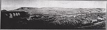

.jpg)