Photos • Location
Santo António | |
|---|---|
Settlement | |
 | |
| Coordinates: 15°16′30″N 23°07′23″W / 15.275°N 23.123°W | |
| Country | Cape Verde |
| Island | Maio |
| Municipality | Maio |
| Civil parish | Nossa Senhora da Luz |
| Population (2010)
[1] | |
| • Total | 22 |
| ID | 61113 |
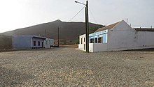
Santo António ( Portuguese meaning Saint Anthony) is a village in the northeastern part of the island of Maio. It is located 18 km northeast of the island capital Porto Inglês.
See also
References
- ^ "2010 Census results". Instituto Nacional de Estatística Cabo Verde (in Portuguese). 24 November 2016.
Santo António | |
|---|---|
Settlement | |
 | |
| Coordinates: 15°16′30″N 23°07′23″W / 15.275°N 23.123°W | |
| Country | Cape Verde |
| Island | Maio |
| Municipality | Maio |
| Civil parish | Nossa Senhora da Luz |
| Population (2010)
[1] | |
| • Total | 22 |
| ID | 61113 |
Santo António ( Portuguese meaning Saint Anthony) is a village in the northeastern part of the island of Maio. It is located 18 km northeast of the island capital Porto Inglês.
See also
References
- ^ "2010 Census results". Instituto Nacional de Estatística Cabo Verde (in Portuguese). 24 November 2016.

