Photos • Location
Morrinho | |
|---|---|
Settlement | |
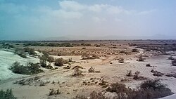
 Wilderness near Morrinho | |
| Coordinates: 15°15′58″N 23°12′18″W / 15.266°N 23.205°W | |
| Country | Cape Verde |
| Island | Maio |
| Municipality | Maio |
| Civil parish | Nossa Senhora da Luz |
| Elevation | 10 m (30 ft) |
| Population (2010)
[1] | |
| • Total | 444 |
| ID | 61105 |
Morrinho is a settlement in the northwest of the island of Maio in Cape Verde. It is 14 km north of the island capital Porto Inglês and 4 km north of Calheta. As of the 2010 census, its population was 444. To its north are the nature reserve Terras Salgadas and the beach of Baía da Santana.
See also
References
- ^ "2010 Census results". Instituto Nacional de Estatística Cabo Verde (in Portuguese). 24 November 2016.
Morrinho | |
|---|---|
Settlement | |
 Wilderness near Morrinho | |
| Coordinates: 15°15′58″N 23°12′18″W / 15.266°N 23.205°W | |
| Country | Cape Verde |
| Island | Maio |
| Municipality | Maio |
| Civil parish | Nossa Senhora da Luz |
| Elevation | 10 m (30 ft) |
| Population (2010)
[1] | |
| • Total | 444 |
| ID | 61105 |
Morrinho is a settlement in the northwest of the island of Maio in Cape Verde. It is 14 km north of the island capital Porto Inglês and 4 km north of Calheta. As of the 2010 census, its population was 444. To its north are the nature reserve Terras Salgadas and the beach of Baía da Santana.
See also
References
- ^ "2010 Census results". Instituto Nacional de Estatística Cabo Verde (in Portuguese). 24 November 2016.

