39°44′13″N 45°23′15″E / 39.73694°N 45.38750°E
Malishka
Մալիշկա | |
|---|---|
Village Rural Community | |
 A view of Malishka | |
 Malishka  Malishka | |
| Coordinates: 39°44′13″N 45°23′15″E / 39.73694°N 45.38750°E | |
| Country | Armenia |
| Province | Vayots Dzor |
| Municipality | Yeghegnadzor |
| Area | |
| • Total | 86 km2 (33 sq mi) |
| Population | |
| • Total | 4,460 |
| Time zone | UTC+4 ( AMT) |
| Malishka at GEOnet Names Server | |
Malishka ( Armenian: Մալիշկա) is a village and rural municipal community of the Yeghegnadzor Municipality of the Vayots Dzor Province of Armenia.
Economy
Almost all of the population lives by subsistence farming. The only other places of employment in the village are the two village schools, the two kindergartens, or one of the many "khanuts" (shops).
Education
Peace Corps volunteers have been active in Malishka, [2] having taught English and holding after-school English clubs at Malishka Secondary School no. 1.
Historical and Cultural Monuments
The ruins of ancient Moz town are located 3-4 km southeast of the village of Malishka, on a 1,200 meter high hill above the right bank of the Arpa River. The town was destroyed by an earthquake and volcanic eruption in the year of 735.
The village also features with st. Gevorg church (1850), a 7th century castle, cross-stones of the 9-14th centuries. The medieval fortresses "Berdajur" and "Ahekaberd" are located in the vicinity of the village, and 1.5 km east, there is a bridge of the 18th century.
Notable people
- Narine Dovlatyan, jazz singer and actress
Gallery
-
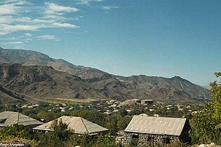 A view of the village
 -
 St. Anna church in Malishka
 -
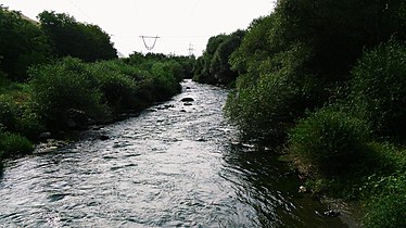 Malishka River


References
External links
Capital:
Yeghegnadzor | ||
| Urban settlements |  | |
| Areni Municipality | ||
| Jermuk Municipality | ||
| Vayk Municipality | ||
| Yeghegis Municipality | ||
| Yeghegnadzor Municipality | ||
| International | |
|---|---|
| National | |
|
| This article about a location in Vayots Dzor Province, Armenia is a stub. You can help Wikipedia by expanding it. |
39°44′13″N 45°23′15″E / 39.73694°N 45.38750°E
Malishka
Մալիշկա | |
|---|---|
Village Rural Community | |
|
A view of Malishka | |
Malishka Malishka | |
| Coordinates: 39°44′13″N 45°23′15″E / 39.73694°N 45.38750°E | |
| Country | Armenia |
| Province | Vayots Dzor |
| Municipality | Yeghegnadzor |
| Area | |
| • Total | 86 km2 (33 sq mi) |
| Population | |
| • Total | 4,460 |
| Time zone | UTC+4 ( AMT) |
| Malishka at GEOnet Names Server | |
Malishka ( Armenian: Մալիշկա) is a village and rural municipal community of the Yeghegnadzor Municipality of the Vayots Dzor Province of Armenia.
Economy
Almost all of the population lives by subsistence farming. The only other places of employment in the village are the two village schools, the two kindergartens, or one of the many "khanuts" (shops).
Education
Peace Corps volunteers have been active in Malishka, [2] having taught English and holding after-school English clubs at Malishka Secondary School no. 1.
Historical and Cultural Monuments
The ruins of ancient Moz town are located 3-4 km southeast of the village of Malishka, on a 1,200 meter high hill above the right bank of the Arpa River. The town was destroyed by an earthquake and volcanic eruption in the year of 735.
The village also features with st. Gevorg church (1850), a 7th century castle, cross-stones of the 9-14th centuries. The medieval fortresses "Berdajur" and "Ahekaberd" are located in the vicinity of the village, and 1.5 km east, there is a bridge of the 18th century.
Notable people
- Narine Dovlatyan, jazz singer and actress
Gallery
-
A view of the village
-
St. Anna church in Malishka
-
Malishka River
References
External links
Capital:
Yeghegnadzor | ||
| Urban settlements | | |
| Areni Municipality | ||
| Jermuk Municipality | ||
| Vayk Municipality | ||
| Yeghegis Municipality | ||
| Yeghegnadzor Municipality | ||
| International | |
|---|---|
| National | |
|
| This article about a location in Vayots Dzor Province, Armenia is a stub. You can help Wikipedia by expanding it. |