39°47′01″N 45°13′41″E / 39.78361°N 45.22806°E
Aghavnadzor
Աղավնաձոր | |
|---|---|
 | |
 Aghavnadzor  Aghavnadzor | |
| Coordinates: 39°47′01″N 45°13′41″E / 39.78361°N 45.22806°E | |
| Country | Armenia |
| Province | Vayots Dzor |
| Municipality | Areni |
| Population | |
| • Total | 1,890 |
| Time zone | UTC+4 ( AMT) |
| Aghavnadzor, Vayots Dzor at GEOnet Names Server | |
Aghavnadzor ( Armenian: Աղավնաձոր) is a village in the Areni Municipality of the Vayots Dzor Province in Armenia.
The 12th-century church of Saint Astvatsatsin is 4 km northeast of Aghavnadzor, with a funerary monument from the year 1009 nearby. The ruins of a caravanserai are located 4 km to the northwest, and 4 km north is the 13th to 14th-century Ul Gyughi church. The 13th-century Aghjkaberd fortress is located 1 km east of the village.
Toponymy
The village was previously known as Aynadzor and Aynazur.
Gallery
-
 Scenery around St. Holy Mother of God Church
 -
 St. Holy Mother of God Church
 -
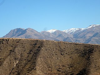 Scenery around Aghavnadzor
 -
 Scenery around Aghavnadzor
 -
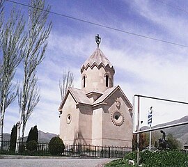 St. Mary Church

.jpg)
.jpg)
.jpg)
.jpg)
References
External links
- Report of the results of the 2001 Armenian Census, Statistical Committee of Armenia
- Kiesling, Brady (2005), Rediscovering Armenia: Guide, Yerevan, Armenia: Matit Graphic Design Studio
- Kiesling, Brady (June 2000). Rediscovering Armenia: An Archaeological/Touristic Gazetteer and Map Set for the Historical Monuments of Armenia (PDF). Archived (PDF) from the original on 6 November 2021.
Capital:
Yeghegnadzor | ||
| Urban settlements |  | |
| Areni Municipality | ||
| Jermuk Municipality | ||
| Vayk Municipality | ||
| Yeghegis Municipality | ||
| Yeghegnadzor Municipality | ||
|
| This article about a location in Vayots Dzor Province, Armenia is a stub. You can help Wikipedia by expanding it. |
39°47′01″N 45°13′41″E / 39.78361°N 45.22806°E
Aghavnadzor
Աղավնաձոր | |
|---|---|
|
| |
Aghavnadzor Aghavnadzor | |
| Coordinates: 39°47′01″N 45°13′41″E / 39.78361°N 45.22806°E | |
| Country | Armenia |
| Province | Vayots Dzor |
| Municipality | Areni |
| Population | |
| • Total | 1,890 |
| Time zone | UTC+4 ( AMT) |
| Aghavnadzor, Vayots Dzor at GEOnet Names Server | |
Aghavnadzor ( Armenian: Աղավնաձոր) is a village in the Areni Municipality of the Vayots Dzor Province in Armenia.
The 12th-century church of Saint Astvatsatsin is 4 km northeast of Aghavnadzor, with a funerary monument from the year 1009 nearby. The ruins of a caravanserai are located 4 km to the northwest, and 4 km north is the 13th to 14th-century Ul Gyughi church. The 13th-century Aghjkaberd fortress is located 1 km east of the village.
Toponymy
The village was previously known as Aynadzor and Aynazur.
Gallery
-
Scenery around St. Holy Mother of God Church
-
St. Holy Mother of God Church
-
Scenery around Aghavnadzor
-
Scenery around Aghavnadzor
-
St. Mary Church
References
External links
- Report of the results of the 2001 Armenian Census, Statistical Committee of Armenia
- Kiesling, Brady (2005), Rediscovering Armenia: Guide, Yerevan, Armenia: Matit Graphic Design Studio
- Kiesling, Brady (June 2000). Rediscovering Armenia: An Archaeological/Touristic Gazetteer and Map Set for the Historical Monuments of Armenia (PDF). Archived (PDF) from the original on 6 November 2021.
Capital:
Yeghegnadzor | ||
| Urban settlements | | |
| Areni Municipality | ||
| Jermuk Municipality | ||
| Vayk Municipality | ||
| Yeghegis Municipality | ||
| Yeghegnadzor Municipality | ||
|
| This article about a location in Vayots Dzor Province, Armenia is a stub. You can help Wikipedia by expanding it. |