Photos • Location
Location of
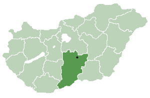
Bács-Kiskun county in
Hungary

Móricgát | |
|---|---|
| Country | |
| County | Bács-Kiskun |
| Area | |
| • Total | 32.88 km2 (12.70 sq mi) |
| Population (2002) | |
| • Total | 554 |
| • Density | 16.84/km2 (43.6/sq mi) |
| Time zone | UTC+1 ( CET) |
| • Summer ( DST) | UTC+2 ( CEST) |
| Postal code | 6132 |
| Area code | 77 |

Móricgát is a village in Bács-Kiskun county, in the Southern Great Plain region of southern Hungary.
Geography
It covers an area of 32.88 km2 (13 sq mi) and has a population of 554 people (2002).
External links
- (in Hungarian) Móricgát hivatalos honlapja
- (in Hungarian) Móricgát a Gyalogló.hu-n


46°38′N 19°40′E / 46.633°N 19.667°E
|
| This Bács-Kiskun location article is a stub. You can help Wikipedia by expanding it. |
Móricgát | |
|---|---|
| Country | |
| County | Bács-Kiskun |
| Area | |
| • Total | 32.88 km2 (12.70 sq mi) |
| Population (2002) | |
| • Total | 554 |
| • Density | 16.84/km2 (43.6/sq mi) |
| Time zone | UTC+1 ( CET) |
| • Summer ( DST) | UTC+2 ( CEST) |
| Postal code | 6132 |
| Area code | 77 |
Móricgát is a village in Bács-Kiskun county, in the Southern Great Plain region of southern Hungary.
Geography
It covers an area of 32.88 km2 (13 sq mi) and has a population of 554 people (2002).
External links
- (in Hungarian) Móricgát hivatalos honlapja
- (in Hungarian) Móricgát a Gyalogló.hu-n
46°38′N 19°40′E / 46.633°N 19.667°E
|
| This Bács-Kiskun location article is a stub. You can help Wikipedia by expanding it. |