| Fogo Natural Park | |
|---|---|
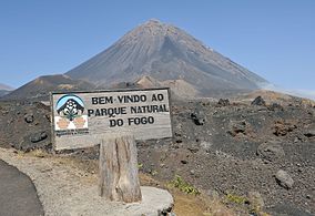
 Welcome sign into the Natural Park | |
| Coordinates | 14°57′N 24°22′W / 14.95°N 24.36°W |
| Area | 84.69 km2 (32.70 sq mi) |
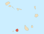
Fogo Natural Park ( Portuguese: Parque Natural do Fogo), on the island of Fogo, is one of ten "natural parks" in the country of Cape Verde. [1] The protected area is 84.69 km2 (32.70 sq mi), [2] [1] which is 17.8% of the total area of the island. [3] 50% of the park lies within the municipality Santa Catarina do Fogo, 28% in municipality of Mosteiros and 22% in São Filipe. [1] The natural park is situated in the interior of the island, and covers the volcano Pico do Fogo, its crater and crater rim ( Bordeira) and the forest of Monte Velha. The volcano is active; the most recent eruption was in 2014-15. [4]
Flora and fauna
The volcano area of Fogo is an Important Bird Area. Key bird species are Fea's petrel, Boyd's shearwater and Cape Verde swift. [5] The ocean around the island of Fogo is another Important Bird Area covering 2,473 km2 (955 sq mi). [6]
The endemic plants Echium vulcanorum ( endangered) [7] and Erysimum caboverdeanum ( critically endangered) [8] are only found on the outer crater rim of the volcano of Fogo. [5]
References
- ^ a b c Parques Naturais, Áreas protegidas Cabo Verde
- ^ Resolução nº 36/2016 Archived 2021-01-18 at the Wayback Machine, Estratégia e Plano Nacional de Negócios das Áreas Protegidas
- ^ Estatísticas do Ambiente - 2016, Instituto Nacional de Estatística, p. 24
- ^ Eruptive history of Mount Fogo at the Smithsonian Global Volcanism Program
- ^ a b "Volcano area, Ilha do Fogo". Important Bird Areas factsheet. BirdLife International. 2018. Retrieved 2018-08-07.
- ^ "Volcano area, Ilha do Fogo - Marine". Important Bird Areas factsheet. BirdLife International. 2018. Retrieved 2018-08-07.
- ^ Catarino, S.; Duarte, M.C.; Romeiras, M.M. (2017). "Echium vulcanorum". IUCN Red List of Threatened Species. 2017: e.T107425957A107468177. doi: 10.2305/IUCN.UK.2017-3.RLTS.T107425957A107468177.en. Retrieved 6 January 2020.
- ^ Catarino, S.; Duarte, M.C.; Romeiras, M.M. (2017). "Erysimum caboverdeanum". IUCN Red List of Threatened Species. 2017: e.T107426112A107468187. doi: 10.2305/IUCN.UK.2017-3.RLTS.T107426112A107468187.en. Retrieved 12 November 2021.
| Fogo Natural Park | |
|---|---|
 Welcome sign into the Natural Park | |
| Coordinates | 14°57′N 24°22′W / 14.95°N 24.36°W |
| Area | 84.69 km2 (32.70 sq mi) |
Fogo Natural Park ( Portuguese: Parque Natural do Fogo), on the island of Fogo, is one of ten "natural parks" in the country of Cape Verde. [1] The protected area is 84.69 km2 (32.70 sq mi), [2] [1] which is 17.8% of the total area of the island. [3] 50% of the park lies within the municipality Santa Catarina do Fogo, 28% in municipality of Mosteiros and 22% in São Filipe. [1] The natural park is situated in the interior of the island, and covers the volcano Pico do Fogo, its crater and crater rim ( Bordeira) and the forest of Monte Velha. The volcano is active; the most recent eruption was in 2014-15. [4]
Flora and fauna
The volcano area of Fogo is an Important Bird Area. Key bird species are Fea's petrel, Boyd's shearwater and Cape Verde swift. [5] The ocean around the island of Fogo is another Important Bird Area covering 2,473 km2 (955 sq mi). [6]
The endemic plants Echium vulcanorum ( endangered) [7] and Erysimum caboverdeanum ( critically endangered) [8] are only found on the outer crater rim of the volcano of Fogo. [5]
References
- ^ a b c Parques Naturais, Áreas protegidas Cabo Verde
- ^ Resolução nº 36/2016 Archived 2021-01-18 at the Wayback Machine, Estratégia e Plano Nacional de Negócios das Áreas Protegidas
- ^ Estatísticas do Ambiente - 2016, Instituto Nacional de Estatística, p. 24
- ^ Eruptive history of Mount Fogo at the Smithsonian Global Volcanism Program
- ^ a b "Volcano area, Ilha do Fogo". Important Bird Areas factsheet. BirdLife International. 2018. Retrieved 2018-08-07.
- ^ "Volcano area, Ilha do Fogo - Marine". Important Bird Areas factsheet. BirdLife International. 2018. Retrieved 2018-08-07.
- ^ Catarino, S.; Duarte, M.C.; Romeiras, M.M. (2017). "Echium vulcanorum". IUCN Red List of Threatened Species. 2017: e.T107425957A107468177. doi: 10.2305/IUCN.UK.2017-3.RLTS.T107425957A107468177.en. Retrieved 6 January 2020.
- ^ Catarino, S.; Duarte, M.C.; Romeiras, M.M. (2017). "Erysimum caboverdeanum". IUCN Red List of Threatened Species. 2017: e.T107426112A107468187. doi: 10.2305/IUCN.UK.2017-3.RLTS.T107426112A107468187.en. Retrieved 12 November 2021.

