Photos • Location
Miguel Gonçalves | |
|---|---|
Settlement | |
| Coordinates: 14°54′25″N 24°25′30″W / 14.907°N 24.425°W | |
| Country | Cape Verde |
| Island | Fogo |
| Municipality | São Filipe |
| Civil parish | Nossa Senhora da Conceição |
| Population (2010)
[1] | |
| • Total | 119 |
| ID | 82298 |
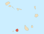
Miguel Gonçalves is a settlement in the central part of the island of Fogo, Cape Verde. It is situated at about 850 m elevation, 8 km east of the island capital São Filipe.
- ^ "2010 Census results". Instituto Nacional de Estatística Cabo Verde (in Portuguese). 24 November 2016.

