Pedra de Lume | |
|---|---|
Settlement | |
 | |
| Coordinates: 16°45′47″N 22°53′42″W / 16.763°N 22.895°W | |
| Country | Cape Verde |
| Island | Sal |
| Municipality | Sal |
| Civil parish | Nossa Senhora das Dores |
| Elevation | 3 m (10 ft) |
| Population (2010)
[1] | |
| • Total | 329 |
| ID | 41102 |
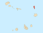
Pedra de Lume is a village in the northeastern part of the island of Sal, Cape Verde. The village is situated on the east coast, about 5 km east of the island capital Espargos. It has a small port and a lighthouse, Farol de Pedra de Lume.
Salt ponds
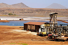
Pedra de Lume has been famous for its salt evaporation ponds (salinas), [2] exploitation of which began in the 18th century. According to geologists, the waters in the lake rise from deep in the earth rather than from lateral infiltration from the ocean. [3] The salinas are situated in the crater of an extinct volcano. Together with the mountain Cagarral, the salinas and the crater form a protected landscape, covering 8.02 km2 (3.10 sq mi). [4] [5]


History

Pedra de Lume was founded by Manuel António Martins, who started the exploitation of the salt ponds in 1796. [6] A tunnel to the salt ponds was constructed in 1804, and a port in 1805. [7] Salt production flourished in most of the 19th century, but went into decline after 1887, when Brazil, the main export destination, imposed a ban on imported salt. [6] Salt production was revived by the French company Salins du Cap Vert, that installed an 1100 m aerial tramway for salt transport in 1921. Current production is small, and mainly intended for beauty products and thalassotherapy. [6]
Notable people
- Ildo Lobo, singer
- Mirri Lobo, singer
See also
References
- ^ "2010 Census results". Instituto Nacional de Estatística Cabo Verde (in Portuguese). 24 November 2016.
- ^ José Joaquim Lopes de Lima, Francisco Maria Bordalo (1844). Ensaios sobre a statistica das possessões portuguezas na Africa occidental e oriental; na Asia occidental; na China, e na Oceania: escriptos de Ordem do Governo de sua Magestade Fidelissima a Senhora D. Maria II por José Joaquim Lopes de Lima ... Imprensa Nacional. p. 182.
- ^ Ray Almeida. "A History of Ilha do Sal". Archived from the original on 6 February 2016.
- ^ Resolução nº 36/2016, Estratégia e Plano Nacional de Negócios das Áreas Protegidas
- ^ Paisagens Protegidas, Áreas protegidas Cabo Verde
- ^ a b c Salines de Pedra de Lume, UNESCO World Heritage tentative list (in French)
- ^ História da Ilha do Sal, Câmara Municipal do Sal
External links
![]() Media related to
Pedra de Lume at Wikimedia Commons
Media related to
Pedra de Lume at Wikimedia Commons
Pedra de Lume | |
|---|---|
Settlement | |
 | |
| Coordinates: 16°45′47″N 22°53′42″W / 16.763°N 22.895°W | |
| Country | Cape Verde |
| Island | Sal |
| Municipality | Sal |
| Civil parish | Nossa Senhora das Dores |
| Elevation | 3 m (10 ft) |
| Population (2010)
[1] | |
| • Total | 329 |
| ID | 41102 |
Pedra de Lume is a village in the northeastern part of the island of Sal, Cape Verde. The village is situated on the east coast, about 5 km east of the island capital Espargos. It has a small port and a lighthouse, Farol de Pedra de Lume.
Salt ponds
Pedra de Lume has been famous for its salt evaporation ponds (salinas), [2] exploitation of which began in the 18th century. According to geologists, the waters in the lake rise from deep in the earth rather than from lateral infiltration from the ocean. [3] The salinas are situated in the crater of an extinct volcano. Together with the mountain Cagarral, the salinas and the crater form a protected landscape, covering 8.02 km2 (3.10 sq mi). [4] [5]


History

Pedra de Lume was founded by Manuel António Martins, who started the exploitation of the salt ponds in 1796. [6] A tunnel to the salt ponds was constructed in 1804, and a port in 1805. [7] Salt production flourished in most of the 19th century, but went into decline after 1887, when Brazil, the main export destination, imposed a ban on imported salt. [6] Salt production was revived by the French company Salins du Cap Vert, that installed an 1100 m aerial tramway for salt transport in 1921. Current production is small, and mainly intended for beauty products and thalassotherapy. [6]
Notable people
- Ildo Lobo, singer
- Mirri Lobo, singer
See also
References
- ^ "2010 Census results". Instituto Nacional de Estatística Cabo Verde (in Portuguese). 24 November 2016.
- ^ José Joaquim Lopes de Lima, Francisco Maria Bordalo (1844). Ensaios sobre a statistica das possessões portuguezas na Africa occidental e oriental; na Asia occidental; na China, e na Oceania: escriptos de Ordem do Governo de sua Magestade Fidelissima a Senhora D. Maria II por José Joaquim Lopes de Lima ... Imprensa Nacional. p. 182.
- ^ Ray Almeida. "A History of Ilha do Sal". Archived from the original on 6 February 2016.
- ^ Resolução nº 36/2016, Estratégia e Plano Nacional de Negócios das Áreas Protegidas
- ^ Paisagens Protegidas, Áreas protegidas Cabo Verde
- ^ a b c Salines de Pedra de Lume, UNESCO World Heritage tentative list (in French)
- ^ História da Ilha do Sal, Câmara Municipal do Sal
External links
![]() Media related to
Pedra de Lume at Wikimedia Commons
Media related to
Pedra de Lume at Wikimedia Commons

