
Original file (SVG file, nominally 520 × 709 pixels, file size: 30 KB)
| This is a file from the
Wikimedia Commons. Information from its
description page there is shown below. Commons is a freely licensed media file repository. You can help. |
Summary
| Description |
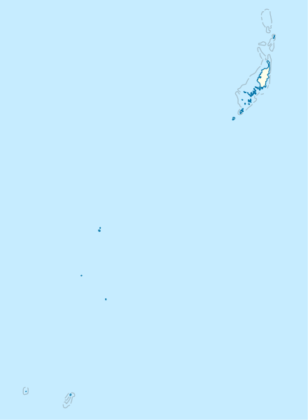
Deutsch: Positionskarte von
Palau
Quadratische Plattkarte. Geographische Begrenzung der Karte:
English: Location map of
Palau
Equirectangular projection. Geographic limits of the map:
|
|
| Date | ||
| Source |
Own work, using
|
|
| Author | NordNordWest | |
| Permission ( Reusing this file) |
This file is licensed under the
Creative Commons
Attribution-Share Alike 3.0 Germany license.
 This file is licensed under the
Creative Commons
Attribution-Share Alike 3.0 Germany license.
|
|
| Other versions |
|


_location_map.svg)

|
This map has been made or improved in the German
Kartenwerkstatt (Map Lab). You can
propose maps to improve as well.
|
File history
Click on a date/time to view the file as it appeared at that time.
| Date/Time | Thumbnail | Dimensions | User | Comment | |
|---|---|---|---|---|---|
| current | 16:02, 14 November 2009 |
| 520 × 709 (30 KB) | NordNordWest | == {{int:filedesc}} == {{Information |Description= {{de|Positionskarte von Palau}} Quadratische Plattkarte. Geographische Begrenzung der Karte: * N: 8.6° N * S: 2.6° N * W: 130.8° O * O: 135.2° O {{en|Location map of Palau} |
File usage
- 2004 Palau Soccer League
- 2006–07 Palau Soccer League
- 2014 Palau Soccer League
- Airai Bai
- Angaur Airstrip
- Babeldaob
- Battle of Angaur
- Battle of Peleliu
- Bkulangriil
- Bkurrengel
- Clear Lake (Palau)
- Eil Malk
- Elab (Palau)
- Goby Lake
- Ibobang
- Imelchol Village
- Imeong Conservation Area
- Imetang
- Jellyfish Lake
- Kloulklubed
- Koror (city)
- Koska, Palau
- Lake Ngardok
- List of World Heritage Sites in Palau
- Melekeok (town)
- Meteu 'L Klechem
- Meyuns
- Mount Ngerchelchuus
- Ngereklmadel
- Ngeremasch
- Ngermid
- Ngeruktabel
- Ngerulmud
- Ngesang
- Ngetbong
- Ngetkib
- Odalmelech
- Ongael
- Ongeluluul
- Palasia Hotel
- Peleliu Airfield
- Rock Islands
- Southwest Islanders Village
- Tobi (island)
- Uet era Ngermeuangel
- Uet era Ongael
- Ulimang
- Urdmang
- User:Ty654/List of earthquakes from 1965-1969 exceeding magnitude 6+
- Module:Location map/data/Palau
- Module:Location map/data/Palau/doc
Global file usage
The following other wikis use this file:
- Usage on af.wikipedia.org
- Usage on an.wikipedia.org
- Usage on ar.wikipedia.org
- Usage on ast.wikipedia.org
- Usage on az.wikipedia.org
- Usage on bcl.wikipedia.org
- Usage on be-tarask.wikipedia.org
- Usage on be.wikipedia.org
- Usage on bg.wikipedia.org
- Usage on bn.wikipedia.org
- Usage on bs.wikipedia.org
- Usage on ceb.wikipedia.org
View more global usage of this file.
Original file (SVG file, nominally 520 × 709 pixels, file size: 30 KB)
| This is a file from the
Wikimedia Commons. Information from its
description page there is shown below. Commons is a freely licensed media file repository. You can help. |
Summary
| Description |
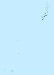
Deutsch: Positionskarte von
Palau
Quadratische Plattkarte. Geographische Begrenzung der Karte:
English: Location map of
Palau
Equirectangular projection. Geographic limits of the map:
|
|
| Date | ||
| Source |
Own work, using
|
|
| Author | NordNordWest | |
| Permission ( Reusing this file) |
This file is licensed under the
Creative Commons
Attribution-Share Alike 3.0 Germany license.
This file is licensed under the
Creative Commons
Attribution-Share Alike 3.0 Germany license.
|
|
| Other versions |
|
|
|
This map has been made or improved in the German
Kartenwerkstatt (Map Lab). You can
propose maps to improve as well.
|
File history
Click on a date/time to view the file as it appeared at that time.
| Date/Time | Thumbnail | Dimensions | User | Comment | |
|---|---|---|---|---|---|
| current | 16:02, 14 November 2009 |
| 520 × 709 (30 KB) | NordNordWest | == {{int:filedesc}} == {{Information |Description= {{de|Positionskarte von Palau}} Quadratische Plattkarte. Geographische Begrenzung der Karte: * N: 8.6° N * S: 2.6° N * W: 130.8° O * O: 135.2° O {{en|Location map of Palau} |
File usage
- 2004 Palau Soccer League
- 2006–07 Palau Soccer League
- 2014 Palau Soccer League
- Airai Bai
- Angaur Airstrip
- Babeldaob
- Battle of Angaur
- Battle of Peleliu
- Bkulangriil
- Bkurrengel
- Clear Lake (Palau)
- Eil Malk
- Elab (Palau)
- Goby Lake
- Ibobang
- Imelchol Village
- Imeong Conservation Area
- Imetang
- Jellyfish Lake
- Kloulklubed
- Koror (city)
- Koska, Palau
- Lake Ngardok
- List of World Heritage Sites in Palau
- Melekeok (town)
- Meteu 'L Klechem
- Meyuns
- Mount Ngerchelchuus
- Ngereklmadel
- Ngeremasch
- Ngermid
- Ngeruktabel
- Ngerulmud
- Ngesang
- Ngetbong
- Ngetkib
- Odalmelech
- Ongael
- Ongeluluul
- Palasia Hotel
- Peleliu Airfield
- Rock Islands
- Southwest Islanders Village
- Tobi (island)
- Uet era Ngermeuangel
- Uet era Ongael
- Ulimang
- Urdmang
- User:Ty654/List of earthquakes from 1965-1969 exceeding magnitude 6+
- Module:Location map/data/Palau
- Module:Location map/data/Palau/doc
Global file usage
The following other wikis use this file:
- Usage on af.wikipedia.org
- Usage on an.wikipedia.org
- Usage on ar.wikipedia.org
- Usage on ast.wikipedia.org
- Usage on az.wikipedia.org
- Usage on bcl.wikipedia.org
- Usage on be-tarask.wikipedia.org
- Usage on be.wikipedia.org
- Usage on bg.wikipedia.org
- Usage on bn.wikipedia.org
- Usage on bs.wikipedia.org
- Usage on ceb.wikipedia.org
View more global usage of this file.