
Size of this PNG preview of this SVG file:
459 × 599 pixels. Other resolutions:
184 × 240 pixels |
368 × 480 pixels |
589 × 768 pixels |
785 × 1,024 pixels |
1,570 × 2,048 pixels |
1,264 × 1,649 pixels.
Original file (SVG file, nominally 1,264 × 1,649 pixels, file size: 593 KB)
| This is a file from the
Wikimedia Commons. Information from its
description page there is shown below. Commons is a freely licensed media file repository. You can help. |
Summary
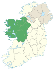
| Description | Locator map of Connacht. |
| Date | (UTC) |
| Source | |
| Author |
|
Licensing
I, the copyright holder of this work, hereby publish it under the following license:
This file is licensed under the
Creative Commons
Attribution-Share Alike 3.0 Unported license.
- You are free:
- to share – to copy, distribute and transmit the work
- to remix – to adapt the work
- Under the following conditions:
- attribution – You must give appropriate credit, provide a link to the license, and indicate if changes were made. You may do so in any reasonable manner, but not in any way that suggests the licensor endorses you or your use.
- share alike – If you remix, transform, or build upon the material, you must distribute your contributions under the same or compatible license as the original.
File history
Click on a date/time to view the file as it appeared at that time.
| Date/Time | Thumbnail | Dimensions | User | Comment | |
|---|---|---|---|---|---|
| current | 14:18, 8 June 2013 |
| 1,264 × 1,649 (593 KB) | Setanta Saki | Including Aran Islands are part of province of Connacht |
| 19:50, 7 January 2012 |
 | 1,450 × 1,807 (687 KB) | NikNaks | Fix | |
| 19:47, 7 January 2012 |
 | 1,450 × 1,807 (687 KB) | NikNaks | Removing modern boundaries | |
| 18:20, 7 January 2012 |
 | 1,450 × 1,807 (708 KB) | NikNaks | Updating to new map | |
| 17:53, 7 January 2012 |
 | 400 × 500 (281 KB) | NikNaks93 | == {{int:filedesc}} == {{Information |Description=Locator map of Connacht. |Source=* File:Ireland_trad_counties_named.svg |Date=2012-01-07 17:50 (UTC) |Author=* File:Ireland_trad_counties_named.svg: *[[:File:Population_density_of_Ireland_map2002 |
File usage
The following pages on the English Wikipedia use this file (pages on other projects are not listed):
- Achill Island
- Barrclashcame
- Ben Gorm
- Ben Lugmore
- Benbaun
- Benbrack
- Benbreen
- Benbulbin
- Bencollaghduff
- Bencorr
- Benglenisky
- Bengower
- Benlettery
- Binn Chaonaigh
- Binn Mhór
- Binn idir an dá Log
- Birreencorragh
- Connacht
- Corcogemore
- Corranabinnia
- Croagh Patrick
- Croaghaun
- Curlew Mountains
- Dartry Mountains
- Derryclare
- Derryclare Lough
- Devilsmother
- Diamond Hill (Ireland)
- Errisbeg
- Garraun (Galway)
- Knockalongy
- Knockmore, Mayo
- Knocknahillion
- Knocknarea
- Knocknashee
- Lackavrea
- Leenaun
- Leenaun Hill
- Letterbreckaun
- Lissoughter
- List of Ireland-related topics
- List of Irish counties by highest point
- List of mountains and hills of County Mayo
- Lists of mountains in Ireland
- Lough Inagh
- Maumtrasna
- Maumturks
- Mullach Glas
- Mweelrea
- Nephin
- Nephin Beg
- Nephin Beg Range
- Ox Mountains
- Partry Mountains
- Seltannasaggart
- Sheeffry Hills
- Sliabh an Iarainn
- Slieve Bawn
- Slieve Carr
- Slievemore
- Tievebaun Mountain
- Truskmore
- Truskmore SE Cairn
- Tully Mountain (Ireland)
- Twelve Bens
- Template:Connaught
- Template:Mountains and hills of Connacht
Global file usage
The following other wikis use this file:
- Usage on ar.wikipedia.org
- Usage on ca.wikipedia.org
- Usage on cs.wikipedia.org
- Usage on da.wikipedia.org
- Usage on es.wikipedia.org
- Usage on fa.wikipedia.org
- Usage on fr.wikipedia.org
- Usage on id.wikipedia.org
- Usage on it.wikipedia.org
- Usage on ja.wikipedia.org
- Usage on kab.wikipedia.org
- Usage on ka.wikipedia.org
- Usage on lv.wikipedia.org
- Usage on mk.wikipedia.org
- Usage on nl.wikipedia.org
- Usage on os.wikipedia.org
- Usage on ps.wikipedia.org
- Usage on pt.wikipedia.org
- Usage on sk.wikipedia.org
- Usage on sr.wikipedia.org
- Usage on tr.wikipedia.org
- Usage on uk.wikipedia.org
- Usage on ur.wikipedia.org
- Usage on vi.wikipedia.org
- Usage on zh-min-nan.wikipedia.org
- Usage on zh-yue.wikipedia.org
- Usage on zh.wikipedia.org
Metadata
Size of this PNG preview of this SVG file:
459 × 599 pixels. Other resolutions:
184 × 240 pixels |
368 × 480 pixels |
589 × 768 pixels |
785 × 1,024 pixels |
1,570 × 2,048 pixels |
1,264 × 1,649 pixels.
Original file (SVG file, nominally 1,264 × 1,649 pixels, file size: 593 KB)
| This is a file from the
Wikimedia Commons. Information from its
description page there is shown below. Commons is a freely licensed media file repository. You can help. |
Summary
| Description | Locator map of Connacht. |
| Date | (UTC) |
| Source | |
| Author |
|
Licensing
I, the copyright holder of this work, hereby publish it under the following license:
This file is licensed under the
Creative Commons
Attribution-Share Alike 3.0 Unported license.
- You are free:
- to share – to copy, distribute and transmit the work
- to remix – to adapt the work
- Under the following conditions:
- attribution – You must give appropriate credit, provide a link to the license, and indicate if changes were made. You may do so in any reasonable manner, but not in any way that suggests the licensor endorses you or your use.
- share alike – If you remix, transform, or build upon the material, you must distribute your contributions under the same or compatible license as the original.
File history
Click on a date/time to view the file as it appeared at that time.
| Date/Time | Thumbnail | Dimensions | User | Comment | |
|---|---|---|---|---|---|
| current | 14:18, 8 June 2013 |
| 1,264 × 1,649 (593 KB) | Setanta Saki | Including Aran Islands are part of province of Connacht |
| 19:50, 7 January 2012 |
| 1,450 × 1,807 (687 KB) | NikNaks | Fix | |
| 19:47, 7 January 2012 |
| 1,450 × 1,807 (687 KB) | NikNaks | Removing modern boundaries | |
| 18:20, 7 January 2012 |
| 1,450 × 1,807 (708 KB) | NikNaks | Updating to new map | |
| 17:53, 7 January 2012 |
| 400 × 500 (281 KB) | NikNaks93 | == {{int:filedesc}} == {{Information |Description=Locator map of Connacht. |Source=* File:Ireland_trad_counties_named.svg |Date=2012-01-07 17:50 (UTC) |Author=* File:Ireland_trad_counties_named.svg: *[[:File:Population_density_of_Ireland_map2002 |
File usage
The following pages on the English Wikipedia use this file (pages on other projects are not listed):
- Achill Island
- Barrclashcame
- Ben Gorm
- Ben Lugmore
- Benbaun
- Benbrack
- Benbreen
- Benbulbin
- Bencollaghduff
- Bencorr
- Benglenisky
- Bengower
- Benlettery
- Binn Chaonaigh
- Binn Mhór
- Binn idir an dá Log
- Birreencorragh
- Connacht
- Corcogemore
- Corranabinnia
- Croagh Patrick
- Croaghaun
- Curlew Mountains
- Dartry Mountains
- Derryclare
- Derryclare Lough
- Devilsmother
- Diamond Hill (Ireland)
- Errisbeg
- Garraun (Galway)
- Knockalongy
- Knockmore, Mayo
- Knocknahillion
- Knocknarea
- Knocknashee
- Lackavrea
- Leenaun
- Leenaun Hill
- Letterbreckaun
- Lissoughter
- List of Ireland-related topics
- List of Irish counties by highest point
- List of mountains and hills of County Mayo
- Lists of mountains in Ireland
- Lough Inagh
- Maumtrasna
- Maumturks
- Mullach Glas
- Mweelrea
- Nephin
- Nephin Beg
- Nephin Beg Range
- Ox Mountains
- Partry Mountains
- Seltannasaggart
- Sheeffry Hills
- Sliabh an Iarainn
- Slieve Bawn
- Slieve Carr
- Slievemore
- Tievebaun Mountain
- Truskmore
- Truskmore SE Cairn
- Tully Mountain (Ireland)
- Twelve Bens
- Template:Connaught
- Template:Mountains and hills of Connacht
Global file usage
The following other wikis use this file:
- Usage on ar.wikipedia.org
- Usage on ca.wikipedia.org
- Usage on cs.wikipedia.org
- Usage on da.wikipedia.org
- Usage on es.wikipedia.org
- Usage on fa.wikipedia.org
- Usage on fr.wikipedia.org
- Usage on id.wikipedia.org
- Usage on it.wikipedia.org
- Usage on ja.wikipedia.org
- Usage on kab.wikipedia.org
- Usage on ka.wikipedia.org
- Usage on lv.wikipedia.org
- Usage on mk.wikipedia.org
- Usage on nl.wikipedia.org
- Usage on os.wikipedia.org
- Usage on ps.wikipedia.org
- Usage on pt.wikipedia.org
- Usage on sk.wikipedia.org
- Usage on sr.wikipedia.org
- Usage on tr.wikipedia.org
- Usage on uk.wikipedia.org
- Usage on ur.wikipedia.org
- Usage on vi.wikipedia.org
- Usage on zh-min-nan.wikipedia.org
- Usage on zh-yue.wikipedia.org
- Usage on zh.wikipedia.org