| Derryclare Lough | |
|---|---|
| Loch Dhoire an Chláir ( Irish) | |
 | |
 Location in Ireland | |
| Location | County Galway |
| Coordinates | 53°28′17″N 9°46′38″W / 53.47139°N 9.77722°W |
| Catchment area | 111.73 km2 (43.1 sq mi) |
| Basin countries | Ireland |
| Max. length | 4 km (2.5 mi) |
| Max. width | 1 km (0.6 mi) |
| Surface area | 2.24 km2 (0.86 sq mi) |
| Surface elevation | 10 m (33 ft) |
| References | [1] [2] [3] |
Derryclare Lough ( Irish: Loch Dhoire an Chláir) [1] is a freshwater lake at the entrance of the Inagh Valley, in Connemara, County Galway, in the west of Ireland.
Geography
Derryclare Lough is located about 20 km (12 mi) east of Clifden on the N59 road. The Twelve Bens mountain range lies to the north of the lake, with the Ben of Derryclare 677 metres (2,221 ft) overlooking the lake itself. Derryclare Lough is fed from rivers from Lough Inagh, which itself is fed from several mountain streams in the area, but most importantly from the Gleninagh River that starts high up in the Gleninagh Valley on the slopes of Benbaun and Bencollaghduff, and the Tooreennacoona River. [4] Derryclare Lough flows into Ballynahinch Lake, where it eventually joins the Owenmore River, and flows into Bertraghboy Bay. [4] [5]
Fishing
Derryclare Lough is noted for its lake and river fishing with spring salmon, grilse and sea trout, and the fishing is done from "Butts" (e.g. long piers from the shore), and particularly the Derryclare Butts, Glendollagh Butts, and the Greenpoint Butts. The Lough and its fishing rights are privately owned and controlled by local fishing lodges in the Inagh Valley. [5] Irish fishing author, Peter O'Reilly, said about Derryclare Lough that "This fishery has everything". [6] [7]
Scenic location
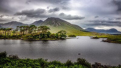
The lake is a popular scenic location, and extensively photographed, and offers views directly into the Glencoaghan Valley of the Twelve Bens and the peaks of the Glencoaghan Horseshoe, a 16–kilometre 8–9 hour route that is considered one of Ireland's best hill-walks. [4] [8] [9] The lough bounds the 19-hectare Derryclare Nature Reserve a Statutory Nature Reserve, and the larger 789-hectare Derryclare Wood, a Coillte owned commercial conifer forest. [10]
Gallery
-
-
 Derryclare with the rest of the Glencoaghan Horseshoe in cloud
 -
 View into the Glencoaghan Horseshoe from Derryclare Lough


Bibliography
- Fairbairn, Helen (2014). Ireland's Best Walks: A Walking Guide. Collins Press. ISBN 978-1848892118.
- Dillion, Paddy (2001). Connemara: Collins Rambler's guide. Harper Collins. ISBN 978-0002201216.
- Dillion, Paddy (1993). The Mountains of Ireland: A Guide to Walking the Summits. Cicerone. ISBN 978-1852841102.
- Peter O'Reilly (1993). TROUT & SALMON RIVERS OF IRELAND - An Angler's Guide. Merlin Unwin. ISBN 978-1873674093.
See also
- Lough Inagh
- Twelve Bens
- Mweelrea, major range in Killary Harbour
- Maumturks, major range in Connemara
- Lists of mountains in Ireland
- List of loughs in Ireland
References
- ^ a b "Loch Dhoire an Chláir/Derryclare Lough". Placenames Database of Ireland. Government of Ireland - Department of Arts, Heritage and the Gaeltacht and Dublin City University. Retrieved 27 December 2015.
- ^ Google (27 December 2015). "Derryclare Lough" (Map). Google Maps. Google. Retrieved 27 December 2015.
- ^ Free, Gary; Little, Ruth; Tierney, Deirdre; Donnelly, Karol & Caroni, Rossana (2006). A Reference Based Typology and Ecological Assessment System for Irish Lakes (PDF) (Report). Environmental Protection Agency (Ireland). p. 11. Retrieved 12 October 2022.
- ^
a
b
c Dillion, Paddy (2001).
Connemara: Collins Rambler's guide. Harper Collins.
ISBN
978-0002201216.
Walk 30: Gleann Chóchan Horseshoe
- ^ a b "Ballynahinch Fishery / Lough Inagh Fishery". Fishing in Ireland. Retrieved 1 August 2019.
- ^ Peter O'Reilly (1993). TROUT & SALMON RIVERS OF IRELAND - An Angler's Guide. Merlin Unwin. ISBN 978-1873674093.
- ^ Peter O'Reilly. "The Great Fishing Houses of Ireland: DERRYCLARE LOUGH & LOUGH INAGH". Ireland Fly Fishing. Retrieved 1 August 2019.
-
^ Helen Fairbairn (30 December 2014). Ireland's Best Walks: A Walking Guide (Walking Guides). Collins Press.
ISBN
978-1848892118.
ROUTE 34: The Glencoaghan Horseshoe. A true classic
-
^ Tony Doherty (22 June 2016).
"A walk for the weekend: The Twelve Bens of Connemara are a hard walk but worth it".
Irish Times.
Even if you had to crawl across bogs to get to them, it would be worth it as the nine peaks which form the Glencoaghan Horseshoe provide some of the most exhilarating mountaineering on this island.
-
^
"Site Name: The Twelve Bens/Garraun Complex SAC" (PDF).
Department of Culture, Heritage and the Gaeltacht. 2017. Retrieved 29 July 2019.
Site Code: 002031
Mountains and hills of
Connacht | |||||||
|---|---|---|---|---|---|---|---|
| Achill Island |  | ||||||
| Dartry Mountains | |||||||
| Maumturks | |||||||
| Mweelrea Mountains | |||||||
| Nephin Range | |||||||
| Ox Mountains | |||||||
| Partry Mountains | |||||||
| Sheeffry Range | |||||||
| Benna Beola |
| ||||||
| Others | |||||||
| Derryclare Lough | |
|---|---|
| Loch Dhoire an Chláir ( Irish) | |
|
| |
Location in Ireland | |
| Location | County Galway |
| Coordinates | 53°28′17″N 9°46′38″W / 53.47139°N 9.77722°W |
| Catchment area | 111.73 km2 (43.1 sq mi) |
| Basin countries | Ireland |
| Max. length | 4 km (2.5 mi) |
| Max. width | 1 km (0.6 mi) |
| Surface area | 2.24 km2 (0.86 sq mi) |
| Surface elevation | 10 m (33 ft) |
| References | [1] [2] [3] |
Derryclare Lough ( Irish: Loch Dhoire an Chláir) [1] is a freshwater lake at the entrance of the Inagh Valley, in Connemara, County Galway, in the west of Ireland.
Geography
Derryclare Lough is located about 20 km (12 mi) east of Clifden on the N59 road. The Twelve Bens mountain range lies to the north of the lake, with the Ben of Derryclare 677 metres (2,221 ft) overlooking the lake itself. Derryclare Lough is fed from rivers from Lough Inagh, which itself is fed from several mountain streams in the area, but most importantly from the Gleninagh River that starts high up in the Gleninagh Valley on the slopes of Benbaun and Bencollaghduff, and the Tooreennacoona River. [4] Derryclare Lough flows into Ballynahinch Lake, where it eventually joins the Owenmore River, and flows into Bertraghboy Bay. [4] [5]
Fishing
Derryclare Lough is noted for its lake and river fishing with spring salmon, grilse and sea trout, and the fishing is done from "Butts" (e.g. long piers from the shore), and particularly the Derryclare Butts, Glendollagh Butts, and the Greenpoint Butts. The Lough and its fishing rights are privately owned and controlled by local fishing lodges in the Inagh Valley. [5] Irish fishing author, Peter O'Reilly, said about Derryclare Lough that "This fishery has everything". [6] [7]
Scenic location
The lake is a popular scenic location, and extensively photographed, and offers views directly into the Glencoaghan Valley of the Twelve Bens and the peaks of the Glencoaghan Horseshoe, a 16–kilometre 8–9 hour route that is considered one of Ireland's best hill-walks. [4] [8] [9] The lough bounds the 19-hectare Derryclare Nature Reserve a Statutory Nature Reserve, and the larger 789-hectare Derryclare Wood, a Coillte owned commercial conifer forest. [10]
Gallery
-
-
Derryclare with the rest of the Glencoaghan Horseshoe in cloud
-
View into the Glencoaghan Horseshoe from Derryclare Lough
Bibliography
- Fairbairn, Helen (2014). Ireland's Best Walks: A Walking Guide. Collins Press. ISBN 978-1848892118.
- Dillion, Paddy (2001). Connemara: Collins Rambler's guide. Harper Collins. ISBN 978-0002201216.
- Dillion, Paddy (1993). The Mountains of Ireland: A Guide to Walking the Summits. Cicerone. ISBN 978-1852841102.
- Peter O'Reilly (1993). TROUT & SALMON RIVERS OF IRELAND - An Angler's Guide. Merlin Unwin. ISBN 978-1873674093.
See also
- Lough Inagh
- Twelve Bens
- Mweelrea, major range in Killary Harbour
- Maumturks, major range in Connemara
- Lists of mountains in Ireland
- List of loughs in Ireland
References
- ^ a b "Loch Dhoire an Chláir/Derryclare Lough". Placenames Database of Ireland. Government of Ireland - Department of Arts, Heritage and the Gaeltacht and Dublin City University. Retrieved 27 December 2015.
- ^ Google (27 December 2015). "Derryclare Lough" (Map). Google Maps. Google. Retrieved 27 December 2015.
- ^ Free, Gary; Little, Ruth; Tierney, Deirdre; Donnelly, Karol & Caroni, Rossana (2006). A Reference Based Typology and Ecological Assessment System for Irish Lakes (PDF) (Report). Environmental Protection Agency (Ireland). p. 11. Retrieved 12 October 2022.
- ^
a
b
c Dillion, Paddy (2001).
Connemara: Collins Rambler's guide. Harper Collins.
ISBN
978-0002201216.
Walk 30: Gleann Chóchan Horseshoe
- ^ a b "Ballynahinch Fishery / Lough Inagh Fishery". Fishing in Ireland. Retrieved 1 August 2019.
- ^ Peter O'Reilly (1993). TROUT & SALMON RIVERS OF IRELAND - An Angler's Guide. Merlin Unwin. ISBN 978-1873674093.
- ^ Peter O'Reilly. "The Great Fishing Houses of Ireland: DERRYCLARE LOUGH & LOUGH INAGH". Ireland Fly Fishing. Retrieved 1 August 2019.
-
^ Helen Fairbairn (30 December 2014). Ireland's Best Walks: A Walking Guide (Walking Guides). Collins Press.
ISBN
978-1848892118.
ROUTE 34: The Glencoaghan Horseshoe. A true classic
-
^ Tony Doherty (22 June 2016).
"A walk for the weekend: The Twelve Bens of Connemara are a hard walk but worth it".
Irish Times.
Even if you had to crawl across bogs to get to them, it would be worth it as the nine peaks which form the Glencoaghan Horseshoe provide some of the most exhilarating mountaineering on this island.
-
^
"Site Name: The Twelve Bens/Garraun Complex SAC" (PDF).
Department of Culture, Heritage and the Gaeltacht. 2017. Retrieved 29 July 2019.
Site Code: 002031
Mountains and hills of
Connacht | |||||||
|---|---|---|---|---|---|---|---|
| Achill Island | | ||||||
| Dartry Mountains | |||||||
| Maumturks | |||||||
| Mweelrea Mountains | |||||||
| Nephin Range | |||||||
| Ox Mountains | |||||||
| Partry Mountains | |||||||
| Sheeffry Range | |||||||
| Benna Beola |
| ||||||
| Others | |||||||
| Long-Distance |
| .jpg)
 | ||||
|---|---|---|---|---|---|---|
| Pilgrim path | ||||||
| Cycle greenway |
| |||||
| Boarded mountain | ||||||
| Fell running | ||||||