| Knocknahillion | |
|---|---|
| Cnoc na hUilleann | |
 Knocknahillion, viewed from
Binn idir an dá Log; behind is the summit of
Letterbreckaun | |
| Highest point | |
| Elevation | 607 m (1,991 ft) [1] |
| Prominence | 152 m (499 ft) [1] |
| Listing | Marilyn, Hewitt, Arderin, Simm, Vandeleur-Lynam |
| Coordinates | 53°31′19″N 9°42′14″W / 53.521816°N 9.703964°W [1] |
| Naming | |
| English translation | hill of the elbow |
| Language of name | Irish |
| Geography | |
 Knocknahillion Location in Ireland | |
| Location | County Galway, Republic of Ireland |
| Parent range | Maumturks |
| OSI/OSNI grid | L8703653756 |
| Topo map | OSi Discovery 37 |
| Geology | |
| Type of rock | Pale quartzites, grits, graphitic top bedrock [1] |
| Climbing | |
| Easiest route | Via pass of Maumahoge |
Knocknahillion ( Irish: Cnoc na hUilleann, meaning "hill of the elbow") [2] is one of the Maumturk Mountains of Connemara in County Galway, Ireland. At 607 metres (1,991 ft), it is the 210th–highest peak in Ireland on the Arderin list, [3] and 256th–highest on the Vandeleur-Lynam list. [4] [5] Knocknahillion is in the middle sector of the long north-west to the south-east spine of the Maumturks. [5] [6] The summit is offset to the west of the rocky central ridge of the Maumturks, and its western-facing slopes have a distinctive "diagonal" rock stratification when viewed from the Inagh Valley. [5] [6]
Naming
Irish academic Paul Tempan notes that Knocknahillion derives its name from the townlands of Illion and Illion West ( Irish: Uillinn, meaning "elbow"). [2] [7] It is to the west of the central spine of the Maumturks range at a point where the range turns to a more south-easterly direction (like an elbow). [6]
Geography
Knocknahillion is in the middle sector of the long north-west to south-east central spine of the Maumturks range in Connemara. [6]
To the north, Knocknahillion is connected to Letterbreckaun, the 2nd highest peak in the range at 667 metres (2,188 ft), by a high winding rocky ridge that includes the subsidiary peak of Knocknahillion North Top at 541 metres (1,775 ft), whose prominence of 38 metres (125 ft) qualifies it as an Arderin. [5] Further along this ridge lies the minor peak of Barrlugrevagh at 558 metres (1,831 ft), whose prominence of 17 metres (56 ft) qualifies it as an Arderin Beg. [5]
To the southeast of Knocknahillion is the col of Maumahoge ( Irish: Mhám Ochóige), which then rises up again to the corrie lake of Lough Maumahoge ( Irish: Loch Mhám Ochóige), and eventually to Binn idir an dá Log, the highest mountain in the range at 702 metres (2,303 ft). [5] [6] [8]
Hill walking
The easiest way summit Knocknahillion is a 5-kilometre 2-3-hour route via the pass of Maumahoge; however, because of its positioning on the high rocky central spine of the central Maumturk range, it is also summited in a longer 14-kilometre 5-6 hour loop-route starting at the col of Maumahoge in the south, climbing Knocknahillion and then along a winding 2-kilometre rocky ridge to the top of Letterbreckaun, before descending via the sharp "v-shaped" col of Maam Turk ( Irish: Mám Tuirc, meaning "pass of the boar"), from which the entire range bears its name. [6] [8] [9]
Knocknahillion is also climbed as part of the Maamturks Challenge, a 25-kilometre 10–12 hour walk over the full Maumturks range (from Maam Cross to Leenaun), which is considered one of the "great classic ridge-walks of Ireland", [8] but of "extreme grade" due to the circa 7,600 feet of total ascent; however, because the peak of Knocknahillon is offset to the west of the core winding rocky ridge, it is not always summited during the challenge. [9] [10] [11] [12]
Rock climbing
While the Maumturks range is not particularly known for rock climbing routes (unlike Bencorr and its Carrot Ridge spur, across the Inagh Valley), some have been developed at a crag just below and west of Lough Maumahoge (L876 532), with routes of 90 to 190 metres at climbing grades of S to HVS. [13]
Gallery
-
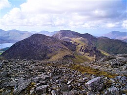
 Looking north to Letterbreckaun (left), and Knocknahillion (right), across Lough Inagh
 -
 Lough Maumahoge, Knocknahillion (left) and the ridge to Letterbreckaun
 -
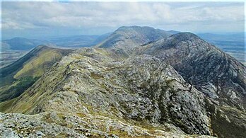 Letterbreckaun to Knockhillion ridge (middle, right), with Binn idir an dá Log (centre, back)
 -
 Looking north to Knocknahillion (left), and Letterbreckaun (middle)
 -
 Maumturks range from the Inagh Valley, with Knocknahillion (centre)
_and_Knocknahillion_(right)_from_Inagh_Valley.jpg)


Bibliography
- Fairbairn, Helen (2014). Ireland's Best Walks: A Walking Guide. Collins Press. ISBN 978-1848892118.
- MountainViews Online Database (Simon Stewart) (2013). A Guide to Ireland's Mountain Summits: The Vandeleur-Lynams & the Arderins. Collins Books. ISBN 978-1-84889-164-7.
- Paul Phelan (2011). Connemara & Mayo - A Walking Guide: Mountain, Coastal & Island Walks. Collins Press. ISBN 978-1848891029.
- Dillion, Paddy (2001). Connemara: Collins Rambler's guide. Harper Collins. ISBN 978-0002201216.
- Dillion, Paddy (1993). The Mountains of Ireland: A Guide to Walking the Summits. Cicerone. ISBN 978-1852841102.
See also
- Twelve Bens, major range in Connemara
- Mweelrea, major range in Killary Harbour
- Lists of mountains in Ireland
- Lists of mountains and hills in the British Isles
- List of Marilyns in the British Isles
- List of Hewitt mountains in England, Wales and Ireland
References
- ^ a b c d "Knocknahillion". MountainViews Online Database. Retrieved 1 August 2019.
- ^ a b Paul Tempan (February 2012). "Irish Hill and Mountain Names" (PDF). MountainViews.ie.
- ^ Simon Stewart (October 2018). "Arderins: Irish mountains of 500+m with a prominence of 30m". MountainViews Online Database.
- ^ Simon Stewart (October 2018). "Vandeleur-Lynams: Irish mountains of 600+m with a prominence of 15m". MountainViews Online Database.
- ^ a b c d e f Mountainviews, (September 2013), "A Guide to Ireland's Mountain Summits: The Vandeleur-Lynams & the Arderins", Collins Books, Cork, ISBN 978-1-84889-164-7
- ^
a
b
c
d
e
f Dillion, Paddy (2001). Connemara: Collins Rambler's guide. Harper Collins.
ISBN
978-0002201216.
Walk 15 Binn Bhriocáin and Mám Tuirc
- ^ "Illion/An Uillinn". Placenames Database of Ireland.
- ^
a
b
c Fairbairn, Helen (2014).
Ireland's Best Walks: A Walking Guide. Collins Press.
ISBN
978-1848892118. Retrieved 1 August 2019.
Route 35: The Central Maumturks – North
- ^
a
b Paul Phelan (2011). Connemara & Mayo - A Walking Guide: Mountain, Coastal & Island Walks. Collins Press.
ISBN
978-1848891029.
Route 19: Letterbreckaun
- ^ "The Maumturks Challenge". University College Galway Mountaineering Club (UCGMC). Retrieved 1 August 2019.
- ^ Simon Stewart. "Maumturks Challenge Section 3: Maumahoge to Maumturkmore". MountainViews Online Database. Retrieved 2 August 2019.
- ^ "Maaumturks Challenge: The Route". University College Galway Mountaineering Club (UCGMC). Retrieved 2 August 2019.
- ^ "Maamturks: Mám Ochóige". Irish Online Climbing Wiki. Retrieved 2 August 2019.
External links
- The Maamturks Challenge, University College Galway Mountaineering Club
- The Maamturks Challenge: Routecard (2015)
- MountainViews: The Irish Mountain Website, Knocknahillion
- MountainViews: Irish Online Mountain Database
- The Database of British and Irish Hills , the largest database of British Isles mountains (" DoBIH")
- Hill Bagging UK & Ireland, the searchable interface for the DoBIH
| British Isles |  | |
|---|---|---|
| Scotland | ||
| Outside Scotland | ||
| England | ||
| Ireland | ||
| County tops | ||
Mountains and hills of
Connacht | |||||||
|---|---|---|---|---|---|---|---|
| Achill Island |  | ||||||
| Dartry Mountains | |||||||
| Maumturks | |||||||
| Mweelrea Mountains | |||||||
| Nephin Range | |||||||
| Ox Mountains | |||||||
| Partry Mountains | |||||||
| Sheeffry Range | |||||||
| Benna Beola |
| ||||||
| Others | |||||||
| Knocknahillion | |
|---|---|
| Cnoc na hUilleann | |
|
Knocknahillion, viewed from
Binn idir an dá Log; behind is the summit of
Letterbreckaun | |
| Highest point | |
| Elevation | 607 m (1,991 ft) [1] |
| Prominence | 152 m (499 ft) [1] |
| Listing | Marilyn, Hewitt, Arderin, Simm, Vandeleur-Lynam |
| Coordinates | 53°31′19″N 9°42′14″W / 53.521816°N 9.703964°W [1] |
| Naming | |
| English translation | hill of the elbow |
| Language of name | Irish |
| Geography | |
Knocknahillion Location in Ireland | |
| Location | County Galway, Republic of Ireland |
| Parent range | Maumturks |
| OSI/OSNI grid | L8703653756 |
| Topo map | OSi Discovery 37 |
| Geology | |
| Type of rock | Pale quartzites, grits, graphitic top bedrock [1] |
| Climbing | |
| Easiest route | Via pass of Maumahoge |
Knocknahillion ( Irish: Cnoc na hUilleann, meaning "hill of the elbow") [2] is one of the Maumturk Mountains of Connemara in County Galway, Ireland. At 607 metres (1,991 ft), it is the 210th–highest peak in Ireland on the Arderin list, [3] and 256th–highest on the Vandeleur-Lynam list. [4] [5] Knocknahillion is in the middle sector of the long north-west to the south-east spine of the Maumturks. [5] [6] The summit is offset to the west of the rocky central ridge of the Maumturks, and its western-facing slopes have a distinctive "diagonal" rock stratification when viewed from the Inagh Valley. [5] [6]
Naming
Irish academic Paul Tempan notes that Knocknahillion derives its name from the townlands of Illion and Illion West ( Irish: Uillinn, meaning "elbow"). [2] [7] It is to the west of the central spine of the Maumturks range at a point where the range turns to a more south-easterly direction (like an elbow). [6]
Geography
Knocknahillion is in the middle sector of the long north-west to south-east central spine of the Maumturks range in Connemara. [6]
To the north, Knocknahillion is connected to Letterbreckaun, the 2nd highest peak in the range at 667 metres (2,188 ft), by a high winding rocky ridge that includes the subsidiary peak of Knocknahillion North Top at 541 metres (1,775 ft), whose prominence of 38 metres (125 ft) qualifies it as an Arderin. [5] Further along this ridge lies the minor peak of Barrlugrevagh at 558 metres (1,831 ft), whose prominence of 17 metres (56 ft) qualifies it as an Arderin Beg. [5]
To the southeast of Knocknahillion is the col of Maumahoge ( Irish: Mhám Ochóige), which then rises up again to the corrie lake of Lough Maumahoge ( Irish: Loch Mhám Ochóige), and eventually to Binn idir an dá Log, the highest mountain in the range at 702 metres (2,303 ft). [5] [6] [8]
Hill walking
The easiest way summit Knocknahillion is a 5-kilometre 2-3-hour route via the pass of Maumahoge; however, because of its positioning on the high rocky central spine of the central Maumturk range, it is also summited in a longer 14-kilometre 5-6 hour loop-route starting at the col of Maumahoge in the south, climbing Knocknahillion and then along a winding 2-kilometre rocky ridge to the top of Letterbreckaun, before descending via the sharp "v-shaped" col of Maam Turk ( Irish: Mám Tuirc, meaning "pass of the boar"), from which the entire range bears its name. [6] [8] [9]
Knocknahillion is also climbed as part of the Maamturks Challenge, a 25-kilometre 10–12 hour walk over the full Maumturks range (from Maam Cross to Leenaun), which is considered one of the "great classic ridge-walks of Ireland", [8] but of "extreme grade" due to the circa 7,600 feet of total ascent; however, because the peak of Knocknahillon is offset to the west of the core winding rocky ridge, it is not always summited during the challenge. [9] [10] [11] [12]
Rock climbing
While the Maumturks range is not particularly known for rock climbing routes (unlike Bencorr and its Carrot Ridge spur, across the Inagh Valley), some have been developed at a crag just below and west of Lough Maumahoge (L876 532), with routes of 90 to 190 metres at climbing grades of S to HVS. [13]
Gallery
-
Looking north to Letterbreckaun (left), and Knocknahillion (right), across Lough Inagh
-
Lough Maumahoge, Knocknahillion (left) and the ridge to Letterbreckaun
-
Letterbreckaun to Knockhillion ridge (middle, right), with Binn idir an dá Log (centre, back)
-
Looking north to Knocknahillion (left), and Letterbreckaun (middle)
-
Maumturks range from the Inagh Valley, with Knocknahillion (centre)
Bibliography
- Fairbairn, Helen (2014). Ireland's Best Walks: A Walking Guide. Collins Press. ISBN 978-1848892118.
- MountainViews Online Database (Simon Stewart) (2013). A Guide to Ireland's Mountain Summits: The Vandeleur-Lynams & the Arderins. Collins Books. ISBN 978-1-84889-164-7.
- Paul Phelan (2011). Connemara & Mayo - A Walking Guide: Mountain, Coastal & Island Walks. Collins Press. ISBN 978-1848891029.
- Dillion, Paddy (2001). Connemara: Collins Rambler's guide. Harper Collins. ISBN 978-0002201216.
- Dillion, Paddy (1993). The Mountains of Ireland: A Guide to Walking the Summits. Cicerone. ISBN 978-1852841102.
See also
- Twelve Bens, major range in Connemara
- Mweelrea, major range in Killary Harbour
- Lists of mountains in Ireland
- Lists of mountains and hills in the British Isles
- List of Marilyns in the British Isles
- List of Hewitt mountains in England, Wales and Ireland
References
- ^ a b c d "Knocknahillion". MountainViews Online Database. Retrieved 1 August 2019.
- ^ a b Paul Tempan (February 2012). "Irish Hill and Mountain Names" (PDF). MountainViews.ie.
- ^ Simon Stewart (October 2018). "Arderins: Irish mountains of 500+m with a prominence of 30m". MountainViews Online Database.
- ^ Simon Stewart (October 2018). "Vandeleur-Lynams: Irish mountains of 600+m with a prominence of 15m". MountainViews Online Database.
- ^ a b c d e f Mountainviews, (September 2013), "A Guide to Ireland's Mountain Summits: The Vandeleur-Lynams & the Arderins", Collins Books, Cork, ISBN 978-1-84889-164-7
- ^
a
b
c
d
e
f Dillion, Paddy (2001). Connemara: Collins Rambler's guide. Harper Collins.
ISBN
978-0002201216.
Walk 15 Binn Bhriocáin and Mám Tuirc
- ^ "Illion/An Uillinn". Placenames Database of Ireland.
- ^
a
b
c Fairbairn, Helen (2014).
Ireland's Best Walks: A Walking Guide. Collins Press.
ISBN
978-1848892118. Retrieved 1 August 2019.
Route 35: The Central Maumturks – North
- ^
a
b Paul Phelan (2011). Connemara & Mayo - A Walking Guide: Mountain, Coastal & Island Walks. Collins Press.
ISBN
978-1848891029.
Route 19: Letterbreckaun
- ^ "The Maumturks Challenge". University College Galway Mountaineering Club (UCGMC). Retrieved 1 August 2019.
- ^ Simon Stewart. "Maumturks Challenge Section 3: Maumahoge to Maumturkmore". MountainViews Online Database. Retrieved 2 August 2019.
- ^ "Maaumturks Challenge: The Route". University College Galway Mountaineering Club (UCGMC). Retrieved 2 August 2019.
- ^ "Maamturks: Mám Ochóige". Irish Online Climbing Wiki. Retrieved 2 August 2019.
External links
- The Maamturks Challenge, University College Galway Mountaineering Club
- The Maamturks Challenge: Routecard (2015)
- MountainViews: The Irish Mountain Website, Knocknahillion
- MountainViews: Irish Online Mountain Database
- The Database of British and Irish Hills , the largest database of British Isles mountains (" DoBIH")
- Hill Bagging UK & Ireland, the searchable interface for the DoBIH
| British Isles | | |
|---|---|---|
| Scotland | ||
| Outside Scotland | ||
| England | ||
| Ireland | ||
| County tops | ||
Mountains and hills of
Connacht | |||||||
|---|---|---|---|---|---|---|---|
| Achill Island | | ||||||
| Dartry Mountains | |||||||
| Maumturks | |||||||
| Mweelrea Mountains | |||||||
| Nephin Range | |||||||
| Ox Mountains | |||||||
| Partry Mountains | |||||||
| Sheeffry Range | |||||||
| Benna Beola |
| ||||||
| Others | |||||||
| Long-Distance |
| .jpg)
 | ||||
|---|---|---|---|---|---|---|
| Pilgrim path | ||||||
| Cycle greenway |
| |||||
| Boarded mountain | ||||||
| Fell running | ||||||