Photos • Location
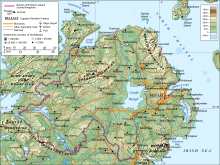
Relief map of
Northern Ireland

Slieve Donard


This is a list of the six traditional counties of Northern Ireland by their highest point. [1] [2] [3] [4]
| Rank | County | Height (m) | Relative height | Name | Grid reference | |
|---|---|---|---|---|---|---|
| 1 | Down | 850 | 822 | Slieve Donard | J357277 | |
| 2–3 | Londonderry and Tyrone | 678 | 657 | Sawel | H618973 | |
| 4 | Fermanagh | 665 | 570 | Cuilcagh | H123281 | |
| 5 | Armagh | 573 | 478 | Slieve Gullion | J025203 | |
| 6 | Antrim | 550 | 515 | Trostan | D179236 | |
See also
- List of Irish counties by highest point
- List of counties of England and Wales in 1964 by highest point
- List of ceremonial counties of England by highest point
- List of mountains and hills of the United Kingdom
- List of Scottish council areas by highest point
- List of Scottish counties by highest point
- List of Welsh principal areas by highest point
- List of Northern Ireland districts by highest point
References
- ^ "Northern Ireland's County High Points - Northern Ireland's Outdoor Adventure Blog". www.outdoorni.com.
- ^ Gribbon, Kieron (5 March 2012). Ireland's County High Points. Gill & Macmillan Ltd. ISBN 9781848899629 – via Google Books.
- ^ "Highest Mountains In Northern Ireland". WorldAtlas.
- ^ Muir, Jonny (15 January 2014). The UK's County Tops: Reaching the top of 91 historic counties. Cicerone Press Limited. ISBN 9781849659635 – via Google Books.
| British Isles |  | |
|---|---|---|
| Scotland | ||
| Outside Scotland | ||
| England | ||
| Ireland | ||
| County tops | ||
This is a list of the six traditional counties of Northern Ireland by their highest point. [1] [2] [3] [4]
| Rank | County | Height (m) | Relative height | Name | Grid reference | |
|---|---|---|---|---|---|---|
| 1 | Down | 850 | 822 | Slieve Donard | J357277 | |
| 2–3 | Londonderry and Tyrone | 678 | 657 | Sawel | H618973 | |
| 4 | Fermanagh | 665 | 570 | Cuilcagh | H123281 | |
| 5 | Armagh | 573 | 478 | Slieve Gullion | J025203 | |
| 6 | Antrim | 550 | 515 | Trostan | D179236 | |
See also
- List of Irish counties by highest point
- List of counties of England and Wales in 1964 by highest point
- List of ceremonial counties of England by highest point
- List of mountains and hills of the United Kingdom
- List of Scottish council areas by highest point
- List of Scottish counties by highest point
- List of Welsh principal areas by highest point
- List of Northern Ireland districts by highest point
References
- ^ "Northern Ireland's County High Points - Northern Ireland's Outdoor Adventure Blog". www.outdoorni.com.
- ^ Gribbon, Kieron (5 March 2012). Ireland's County High Points. Gill & Macmillan Ltd. ISBN 9781848899629 – via Google Books.
- ^ "Highest Mountains In Northern Ireland". WorldAtlas.
- ^ Muir, Jonny (15 January 2014). The UK's County Tops: Reaching the top of 91 historic counties. Cicerone Press Limited. ISBN 9781849659635 – via Google Books.
| British Isles | | |
|---|---|---|
| Scotland | ||
| Outside Scotland | ||
| England | ||
| Ireland | ||
| County tops | ||