
Original file (1,393 × 1,113 pixels, file size: 356 KB, MIME type: image/jpeg)
| This is a file from the
Wikimedia Commons. Information from its
description page there is shown below. Commons is a freely licensed media file repository. You can help. |
Summary
| Description |
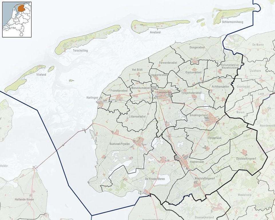
Nederlands: Referentiekaart van Provincie Fryslân, met indeling van gemeenten (2010) en impressie van het landschap.
Door Jan-Willem van Aalst, samengesteld uit publiek beschikbare geo-data:
|
| Date | |
| Source | Own work |
| Author | Janwillemvanaalst |
Licensing
- You are free:
- to share – to copy, distribute and transmit the work
- to remix – to adapt the work
- Under the following conditions:
- attribution – You must give appropriate credit, provide a link to the license, and indicate if changes were made. You may do so in any reasonable manner, but not in any way that suggests the licensor endorses you or your use.
- share alike – If you remix, transform, or build upon the material, you must distribute your contributions under the same or compatible license as the original.
File history
Click on a date/time to view the file as it appeared at that time.
| Date/Time | Thumbnail | Dimensions | User | Comment | |
|---|---|---|---|---|---|
| current | 20:48, 21 April 2014 |
| 1,393 × 1,113 (356 KB) | Tristan Surtel | Update |
| 20:20, 15 January 2010 |
 | 1,223 × 977 (259 KB) | Janwillemvanaalst | {{Information |Description={{nl|1=Referentiekaart van Provincie Fryslân, met indeling van gemeenten (2010) en impressie van het landschap. Door Jan-Willem van Aalst, samengesteld uit publiek beschikbare geo-data: * Referentie-ondergrond (kustlijn, steden |
File usage
More than 100 pages use this file. The following list shows the first 100 pages that use this file only. A full list is available.
- Aalsum, Friesland
- Abbegea
- Achlum
- Akkrum
- Akmarijp
- Alde Leie
- Aldeboarn
- Aldtsjerk
- Allingawier
- Appelscha
- Arum, Netherlands
- Augsbuert-Lytsewâld
- Augustinusga
- Baaium
- Baard, Friesland
- Bakhuizen
- Bakkeveen
- Ballum
- Bantega
- Bartlehiem
- Boazum
- Boelenslaan
- Boksum
- Bolsward
- Breezanddijk
- Britsum
- Buren, Friesland
- Burgum
- Burgumer Mar
- Burum, Friesland
- Damwâld
- De Hoeve
- Dearsum
- Dokkum
- Drachten
- Drogeham
- Dronryp
- Eagum
- Eanjum
- Earnewâld
- Eastermar
- Franeker
- Friens
- Garyp
- Gorredijk
- Goutum
- Gytsjerk
- Hallum
- Harkema
- Hindeloopen
- Hollum
- Holwert
- Hurdegaryp
- IJlst
- Ie, Noardeast-Fryslân
- Jistrum
- Jorwert
- Koarnjum
- Kootstertille
- Kornwerderzand
- Koudum
- Langweer
- Lauwersmeer
- Loënga
- Makkinga
- Midlum, Netherlands
- Minnertsga
- Moarre
- Munnekezijl
- Mûnein
- Nes, Ameland
- Noardburgum
- Oentsjerk
- Offingawier
- Opeinde
- Parrega
- Peperga
- Piaam
- Pingjum
- Rijs
- Ryptsjerk
- Sexbierum
- Siegerswoude
- Sint Annaparochie
- Sint Jacobiparochie
- Sneek
- Stavoren
- Steggerda
- Stiens
- Sumar, Netherlands
- Surhuisterveen
- Surhuizum
- Suwâld
- Twijzel
- Tytsjerk
- Ureterp
- Wijnaldum
- Workum
- Wouda pumping station
- Wyns
View more links to this file.
Global file usage
The following other wikis use this file:
- Usage on br.wikipedia.org
- Usage on fa.wikipedia.org
- Usage on gl.wikipedia.org
- Usage on ja.wikipedia.org
- Usage on nl.wikipedia.org
- Usage on simple.wikipedia.org
- Usage on si.wikipedia.org
- Usage on sl.wikipedia.org
- Usage on uz.wikipedia.org
Original file (1,393 × 1,113 pixels, file size: 356 KB, MIME type: image/jpeg)
| This is a file from the
Wikimedia Commons. Information from its
description page there is shown below. Commons is a freely licensed media file repository. You can help. |
Summary
| Description |
Nederlands: Referentiekaart van Provincie Fryslân, met indeling van gemeenten (2010) en impressie van het landschap.
Door Jan-Willem van Aalst, samengesteld uit publiek beschikbare geo-data:
|
| Date | |
| Source | Own work |
| Author | Janwillemvanaalst |
Licensing
- You are free:
- to share – to copy, distribute and transmit the work
- to remix – to adapt the work
- Under the following conditions:
- attribution – You must give appropriate credit, provide a link to the license, and indicate if changes were made. You may do so in any reasonable manner, but not in any way that suggests the licensor endorses you or your use.
- share alike – If you remix, transform, or build upon the material, you must distribute your contributions under the same or compatible license as the original.
File history
Click on a date/time to view the file as it appeared at that time.
| Date/Time | Thumbnail | Dimensions | User | Comment | |
|---|---|---|---|---|---|
| current | 20:48, 21 April 2014 |
| 1,393 × 1,113 (356 KB) | Tristan Surtel | Update |
| 20:20, 15 January 2010 |
| 1,223 × 977 (259 KB) | Janwillemvanaalst | {{Information |Description={{nl|1=Referentiekaart van Provincie Fryslân, met indeling van gemeenten (2010) en impressie van het landschap. Door Jan-Willem van Aalst, samengesteld uit publiek beschikbare geo-data: * Referentie-ondergrond (kustlijn, steden |
File usage
More than 100 pages use this file. The following list shows the first 100 pages that use this file only. A full list is available.
- Aalsum, Friesland
- Abbegea
- Achlum
- Akkrum
- Akmarijp
- Alde Leie
- Aldeboarn
- Aldtsjerk
- Allingawier
- Appelscha
- Arum, Netherlands
- Augsbuert-Lytsewâld
- Augustinusga
- Baaium
- Baard, Friesland
- Bakhuizen
- Bakkeveen
- Ballum
- Bantega
- Bartlehiem
- Boazum
- Boelenslaan
- Boksum
- Bolsward
- Breezanddijk
- Britsum
- Buren, Friesland
- Burgum
- Burgumer Mar
- Burum, Friesland
- Damwâld
- De Hoeve
- Dearsum
- Dokkum
- Drachten
- Drogeham
- Dronryp
- Eagum
- Eanjum
- Earnewâld
- Eastermar
- Franeker
- Friens
- Garyp
- Gorredijk
- Goutum
- Gytsjerk
- Hallum
- Harkema
- Hindeloopen
- Hollum
- Holwert
- Hurdegaryp
- IJlst
- Ie, Noardeast-Fryslân
- Jistrum
- Jorwert
- Koarnjum
- Kootstertille
- Kornwerderzand
- Koudum
- Langweer
- Lauwersmeer
- Loënga
- Makkinga
- Midlum, Netherlands
- Minnertsga
- Moarre
- Munnekezijl
- Mûnein
- Nes, Ameland
- Noardburgum
- Oentsjerk
- Offingawier
- Opeinde
- Parrega
- Peperga
- Piaam
- Pingjum
- Rijs
- Ryptsjerk
- Sexbierum
- Siegerswoude
- Sint Annaparochie
- Sint Jacobiparochie
- Sneek
- Stavoren
- Steggerda
- Stiens
- Sumar, Netherlands
- Surhuisterveen
- Surhuizum
- Suwâld
- Twijzel
- Tytsjerk
- Ureterp
- Wijnaldum
- Workum
- Wouda pumping station
- Wyns
View more links to this file.
Global file usage
The following other wikis use this file:
- Usage on br.wikipedia.org
- Usage on fa.wikipedia.org
- Usage on gl.wikipedia.org
- Usage on ja.wikipedia.org
- Usage on nl.wikipedia.org
- Usage on simple.wikipedia.org
- Usage on si.wikipedia.org
- Usage on sl.wikipedia.org
- Usage on uz.wikipedia.org