Hollum | |
|---|---|
Village | |
 Hollum | |
 Location in Ameland municipality | |
 Hollum Location in the province of
Friesland  Hollum Hollum (Netherlands) | |
| Coordinates: 53°25′N 5°38′E / 53.417°N 5.633°E | |
| Country |
|
| Province |
|
| Municipality |
|
| Area | |
| • Total | 12.77 km2 (4.93 sq mi) |
| Elevation | 2.2 m (7.2 ft) |
| Population (2021)
[1] | |
| • Total | 1,285 |
| • Density | 100/km2 (260/sq mi) |
| Time zone | UTC+1 ( CET) |
| • Summer ( DST) | UTC+2 ( CEST) |
| Postal code | 9161 |
| Dialing code | 0519 |
Hollum is the largest village on Ameland, Netherlands, one of the West Frisian Islands. It is situated on the westernmost part of the island and had, as of January 2017, a population of 1,165. [3]
The village was first mentioned in 1485 as Hollum, and could mean "settlement on a hill/island", however there are more possiblities. [4] [5] Hollum developed as an esdorp in the Late Middle Ages. It was originally two settlements which have grown together. [6]
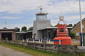
Prominent in the village is a Dutch Reformed church with foundations from the 12th century and a lighthouse, which is 59 m high, dating from 1880. Another notable feature is the Commandeur huuskes. Commandeur refers to the captain of a whaling ship, as were used during the 18th century to hunt in the Arctic Ocean.
Another notable tourist attraction is the Sorgdragersmuseum, a history museum. The smock mill De Verwachting is in working order.
-
 lighthouse Bornrif
 -
 museum Sorgdrager
 -
 maritime museum
 -
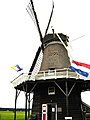 windmill De Verwachting


.jpg)
- ^
a
b
"Kerncijfers wijken en buurten 2021". Central Bureau of Statistics. Retrieved 26 April 2022.
two entries
- ^ "Postcodetool for 9161AA". Actueel Hoogtebestand Nederland (in Dutch). Het Waterschapshuis. Retrieved 26 April 2022.
- ^ Kerncijfers wijken en buurten 2017 - CBS (in Dutch)
- ^ "Hollum - (geografische naam)". Etymologiebank (in Dutch). Retrieved 26 April 2022.
- ^ "Hallum - (geografische naam)". Etymologiebank (in Dutch). Retrieved 26 April 2022.
- ^ Ronald Stenvert & Sabine Broekhoven (2000). "Hollum" (in Dutch). Zwolle: Waanders. ISBN 90 400 9476 4. Retrieved 26 April 2022.
![]() Media related to
Hollum at Wikimedia Commons
Media related to
Hollum at Wikimedia Commons
|
| This Friesland location article is a stub. You can help Wikipedia by expanding it. |
Hollum | |
|---|---|
Village | |
|
Hollum | |
|
Location in Ameland municipality | |
Hollum Location in the province of
Friesland Hollum Hollum (Netherlands) | |
| Coordinates: 53°25′N 5°38′E / 53.417°N 5.633°E | |
| Country |
|
| Province |
|
| Municipality |
|
| Area | |
| • Total | 12.77 km2 (4.93 sq mi) |
| Elevation | 2.2 m (7.2 ft) |
| Population (2021)
[1] | |
| • Total | 1,285 |
| • Density | 100/km2 (260/sq mi) |
| Time zone | UTC+1 ( CET) |
| • Summer ( DST) | UTC+2 ( CEST) |
| Postal code | 9161 |
| Dialing code | 0519 |
Hollum is the largest village on Ameland, Netherlands, one of the West Frisian Islands. It is situated on the westernmost part of the island and had, as of January 2017, a population of 1,165. [3]
The village was first mentioned in 1485 as Hollum, and could mean "settlement on a hill/island", however there are more possiblities. [4] [5] Hollum developed as an esdorp in the Late Middle Ages. It was originally two settlements which have grown together. [6]
Prominent in the village is a Dutch Reformed church with foundations from the 12th century and a lighthouse, which is 59 m high, dating from 1880. Another notable feature is the Commandeur huuskes. Commandeur refers to the captain of a whaling ship, as were used during the 18th century to hunt in the Arctic Ocean.
Another notable tourist attraction is the Sorgdragersmuseum, a history museum. The smock mill De Verwachting is in working order.
-
lighthouse Bornrif
-
museum Sorgdrager
-
maritime museum
-
windmill De Verwachting
- ^
a
b
"Kerncijfers wijken en buurten 2021". Central Bureau of Statistics. Retrieved 26 April 2022.
two entries
- ^ "Postcodetool for 9161AA". Actueel Hoogtebestand Nederland (in Dutch). Het Waterschapshuis. Retrieved 26 April 2022.
- ^ Kerncijfers wijken en buurten 2017 - CBS (in Dutch)
- ^ "Hollum - (geografische naam)". Etymologiebank (in Dutch). Retrieved 26 April 2022.
- ^ "Hallum - (geografische naam)". Etymologiebank (in Dutch). Retrieved 26 April 2022.
- ^ Ronald Stenvert & Sabine Broekhoven (2000). "Hollum" (in Dutch). Zwolle: Waanders. ISBN 90 400 9476 4. Retrieved 26 April 2022.
![]() Media related to
Hollum at Wikimedia Commons
Media related to
Hollum at Wikimedia Commons
|
| This Friesland location article is a stub. You can help Wikipedia by expanding it. |