Britsum | |
|---|---|
Village | |
.jpg) St John's Church | |
 Location in Leeuwarderadeel municipality | |
 Britsum Location in the Netherlands  Britsum Britsum (Netherlands) | |
| Coordinates: 53°15′N 5°47′E / 53.250°N 5.783°E | |
| Country |
|
| Province |
|
| Municipality |
|
| Area | |
| • Total | 4.98 km2 (1.92 sq mi) |
| Elevation | 0.4 m (1.3 ft) |
| Population (2021)
[1] | |
| • Total | 950 |
| • Density | 190/km2 (490/sq mi) |
| Postal code | 9055
[1] |
| Dialing code | 058 |
The village of Britsum is located in the municipality of Leeuwarden (province of Friesland), in the Netherlands. Britsum was built on an artificial bank ( terp) running along the eastern side of the former Middelzee. The church, built around 1300, is also located on this bank.[ citation needed] It had a population of about 910 citizens in January 2017. [3]
It was first mentioned in 944 as Bruggiheim, and means "settlement near a bridge". [4] Britsum is a terp (artificial living mound) village with a radial structure. It dates from the early middle ages and was built near the Middelzee. A large part of the mound was excavation around 1900. [5]
The western side of the Dutch Reformed church dates between 1180 and 1200. The nave and choir date between 1240 and 1260. The church received its present shape in 1875. [5] In 1840, Britsum was home to 326 people. [6]
Britsum was served by a station on the North Friesland Railway which opened in 1901 and closed to passengers in December 1940. The line finally closed in 1997. [7]
Before 2018, the village was part of the Leeuwarderadeel municipality. [6]
-
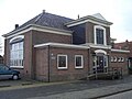 Former school building
 -
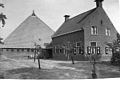 Farm in Britsum


- Joost Klein (born 1997), rapper
- ^
a
b
c
"Kerncijfers wijken en buurten 2021". Central Bureau of Statistics. Retrieved 30 March 2022.
two entries
- ^ "Postcodetool for 9055LN". Actueel Hoogtebestand Nederland (in Dutch). Het Waterschapshuis. Retrieved 30 March 2022.
- ^ Kerncijfers wijken en buurten 2017 - CBS Statline
- ^ "Britsum - (geografische naam)". Etymologiebank (in Dutch). Retrieved 30 March 2022.
- ^ a b Ronald Stenvert & Sabine Broekhoven (2000). "Britsum" (in Dutch). Zwolle: Waanders. ISBN 90 400 9476 4. Retrieved 30 March 2022.
- ^ a b "Britsum". Plaatsengids (in Dutch). Retrieved 30 March 2022.
- ^ "stopplaats Britsum". Stationsweb (in Dutch). Retrieved 30 March 2022.
![]() Media related to
Britsum at Wikimedia Commons
Media related to
Britsum at Wikimedia Commons
Britsum | |
|---|---|
Village | |
|
St John's Church | |
|
Location in Leeuwarderadeel municipality | |
Britsum Location in the Netherlands Britsum Britsum (Netherlands) | |
| Coordinates: 53°15′N 5°47′E / 53.250°N 5.783°E | |
| Country |
|
| Province |
|
| Municipality |
|
| Area | |
| • Total | 4.98 km2 (1.92 sq mi) |
| Elevation | 0.4 m (1.3 ft) |
| Population (2021)
[1] | |
| • Total | 950 |
| • Density | 190/km2 (490/sq mi) |
| Postal code | 9055
[1] |
| Dialing code | 058 |
The village of Britsum is located in the municipality of Leeuwarden (province of Friesland), in the Netherlands. Britsum was built on an artificial bank ( terp) running along the eastern side of the former Middelzee. The church, built around 1300, is also located on this bank.[ citation needed] It had a population of about 910 citizens in January 2017. [3]
It was first mentioned in 944 as Bruggiheim, and means "settlement near a bridge". [4] Britsum is a terp (artificial living mound) village with a radial structure. It dates from the early middle ages and was built near the Middelzee. A large part of the mound was excavation around 1900. [5]
The western side of the Dutch Reformed church dates between 1180 and 1200. The nave and choir date between 1240 and 1260. The church received its present shape in 1875. [5] In 1840, Britsum was home to 326 people. [6]
Britsum was served by a station on the North Friesland Railway which opened in 1901 and closed to passengers in December 1940. The line finally closed in 1997. [7]
Before 2018, the village was part of the Leeuwarderadeel municipality. [6]
-
Former school building
-
Farm in Britsum
- Joost Klein (born 1997), rapper
- ^
a
b
c
"Kerncijfers wijken en buurten 2021". Central Bureau of Statistics. Retrieved 30 March 2022.
two entries
- ^ "Postcodetool for 9055LN". Actueel Hoogtebestand Nederland (in Dutch). Het Waterschapshuis. Retrieved 30 March 2022.
- ^ Kerncijfers wijken en buurten 2017 - CBS Statline
- ^ "Britsum - (geografische naam)". Etymologiebank (in Dutch). Retrieved 30 March 2022.
- ^ a b Ronald Stenvert & Sabine Broekhoven (2000). "Britsum" (in Dutch). Zwolle: Waanders. ISBN 90 400 9476 4. Retrieved 30 March 2022.
- ^ a b "Britsum". Plaatsengids (in Dutch). Retrieved 30 March 2022.
- ^ "stopplaats Britsum". Stationsweb (in Dutch). Retrieved 30 March 2022.
![]() Media related to
Britsum at Wikimedia Commons
Media related to
Britsum at Wikimedia Commons