Photos • Location

Curry, Alabama | |
|---|---|
 Curry, Alabama  Curry, Alabama | |
| Coordinates: 33°29′11″N 86°01′02″W / 33.48639°N 86.01722°W | |
| Country | United States |
| State | Alabama |
| County | Talladega |
| Elevation | 538 ft (164 m) |
| Time zone | UTC-6 ( Central (CST)) |
| • Summer ( DST) | UTC-5 (CDT) |
| Area code(s) | 256 & 938 |
| GNIS feature ID | 159473 [1] |
Curry is an unincorporated community in Talladega County, Alabama, United States, located on Alabama State Route 21, 6.2 miles (10.0 km) northeast of Talladega.
References
Municipalities and communities of
Talladega County, Alabama, United States | ||
|---|---|---|
| Cities | 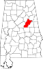 | |
| Towns | ||
| CDPs | ||
|
Unincorporated communities | ||
| Ghost town | ||
| Footnotes | ‡This populated place also has portions in an adjacent county or counties | |
|
| This Talladega County, Alabama state location article is a stub. You can help Wikipedia by expanding it. |
Curry, Alabama | |
|---|---|
Curry, Alabama Curry, Alabama | |
| Coordinates: 33°29′11″N 86°01′02″W / 33.48639°N 86.01722°W | |
| Country | United States |
| State | Alabama |
| County | Talladega |
| Elevation | 538 ft (164 m) |
| Time zone | UTC-6 ( Central (CST)) |
| • Summer ( DST) | UTC-5 (CDT) |
| Area code(s) | 256 & 938 |
| GNIS feature ID | 159473 [1] |
Curry is an unincorporated community in Talladega County, Alabama, United States, located on Alabama State Route 21, 6.2 miles (10.0 km) northeast of Talladega.
References
Municipalities and communities of
Talladega County, Alabama, United States | ||
|---|---|---|
| Cities | | |
| Towns | ||
| CDPs | ||
|
Unincorporated communities | ||
| Ghost town | ||
| Footnotes | ‡This populated place also has portions in an adjacent county or counties | |
|
| This Talladega County, Alabama state location article is a stub. You can help Wikipedia by expanding it. |