Cayenne â FĂ©lix ĂbouĂ© Airport formerly Rochambeau Airport | |||||||||||
|---|---|---|---|---|---|---|---|---|---|---|---|
 | |||||||||||
| Summary | |||||||||||
| Airport type | Public | ||||||||||
| Operator | CCI Guyane [1] | ||||||||||
| Serves | Cayenne, French Guiana | ||||||||||
| Location | Matoury | ||||||||||
| Elevation AMSL | 26 ft / 8 m | ||||||||||
| Coordinates | 04°49âČ11âłN 52°21âČ43âłW / 4.81972°N 52.36194°W | ||||||||||
| Map | |||||||||||
| Runways | |||||||||||
| |||||||||||
| Statistics (2023) | |||||||||||
| |||||||||||
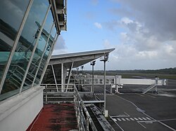
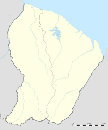
Cayenne â FĂ©lix ĂbouĂ© Airport (French: AĂ©roport de Cayenne â FĂ©lix ĂbouĂ©, IATA: CAY, ICAO: SOCA) is French Guiana's main international airport. It is located near the commune of Matoury, 13 kilometres (8 mi) southwest of French Guiana's capital city of Cayenne. It is managed by the Chamber of Commerce and Industry of French Guiana (CCI Guyane). [1]
Air Guyane Express has its headquarters on the airport property. [7]
History
The first airfield at Cayenne, called "Gallion," was built in 1943 in ten months by the U.S. Army Air Corps as a base allowing bombers to reach Africa. Though quickly abandoned upon the completion of the new airport, it can still be found very close to the aerodrome.
The new airport was first given the name "Rochambeau" in reference to Jean-Baptiste Donatien de Vimeur, comte de Rochambeau, commander-in-chief of the French troops in the American Revolutionary War. [8] It was purchased by France in 1949.
This name was controversial because the airport's namesake's son, Donatien-Marie-Joseph de Vimeur, vicomte de Rochambeau, harshly repressed the Haitian Revolution during the Saint-Domingue expedition. Christiane Taubira, then-Member of the National Assembly of France for Guiana, requested in 1999 that the name be changed. Multiple proposals were submitted, including CĂ©pĂ©rou, a seventeenth-century indigenous chief. It was finally renamed FĂ©lix ĂbouĂ© Airport in 2012, the change becoming official in January of that year. [9] [10] The code for the airport remains CAY. [11]
Félix Eboué Airport serves approximately 400,000 passengers per year. [12]
Facilities
The airport has an elevation of 24 feet (7 m) above mean sea level. It has one paved runway. [3] It is open to public air traffic and international air traffic.
Airlines and destinations
Statistics
Graphs are unavailable due to technical issues. There is more info on
Phabricator and on
MediaWiki.org. |
| 2000 | 2005 | 2006 | 2007 | 2008 | 2009 | 2010 | 2011 | 2012 |
|---|---|---|---|---|---|---|---|---|
| 457 168 | 375 844 | 374 394 | 386 979 | 385 142 | 400 025 | 423 849 | 435 440 | 495 994 |
See also
References
- ^ a b CCI Guyane
- ^ "Résultats d'activité des aéroports français 2018" (PDF). aeroport.fr. Retrieved 31 August 2019.
- ^ a b SOCA â Cayenne FĂ©lix EbouĂ©. AIP from French Service d'information aĂ©ronautique, effective 18 April 2024. CAR SAM NAM
- ^ "AĂ©roport de Cayenne â Rochambeau" (in French). L'Union des AĂ©roports Français. Archived from the original on 4 February 2012. Retrieved 9 June 2019.
- ^ Airport information for SOCA [usurped] from DAFIF (effective 26 October 2006)
- ^ Airport information for CAY at Great Circle Mapper. Source: DAFIF (effective October 2006).
- ^ "Directory: World airlines." Flight International. 16â22 March 2004. 65.
- ^ "CCI Guyane - AĂ©roport / Accueil". Archived from the original on 11 November 2008.
- ^ Laurent Marot (21 January 2012). "Guyana found memory by changing the name of the airport". Le Monde (in French). Retrieved 7 June 2013.
- ^ order of 4 January 2012, J.O. 8 January 2012, NOR TRAA1200009A, http://www.legifrance.gouv.fr/affichTexte.do?cidTexte=JORFTEXT000025114748
- ^ StĂ©phanie Bouillaguet (17 January 2012). "Rochambeau has already become FĂ©lix-ĂbouĂ©". France-Guiana. Retrieved 7 June 2013.
-
^
"Cayenne airport". Aeroports Voyages. Retrieved 22 July 2018.
Comprising of a single terminal building, the airport handles roughly 400,000 passengers per year.
- ^ "Air France NS24 Cayenne Service Adjustment". Aeroroutes. Retrieved 20 July 2023.
- ^ https://www.sxm-talks.com/local-news/air-air-france-opens-a-new-line-between-pointe-a-pitre-and-sint-maarten-faxinfo/
- ^ Source : Site de l'UAF Archived 29 February 2012 at the Wayback Machine
External links
![]() Media related to
Cayenne-Rochambeau Airport at Wikimedia Commons
Media related to
Cayenne-Rochambeau Airport at Wikimedia Commons
Cayenne â FĂ©lix ĂbouĂ© Airport formerly Rochambeau Airport | |||||||||||
|---|---|---|---|---|---|---|---|---|---|---|---|
 | |||||||||||
| Summary | |||||||||||
| Airport type | Public | ||||||||||
| Operator | CCI Guyane [1] | ||||||||||
| Serves | Cayenne, French Guiana | ||||||||||
| Location | Matoury | ||||||||||
| Elevation AMSL | 26 ft / 8 m | ||||||||||
| Coordinates | 04°49âČ11âłN 52°21âČ43âłW / 4.81972°N 52.36194°W | ||||||||||
| Map | |||||||||||
| Runways | |||||||||||
| |||||||||||
| Statistics (2023) | |||||||||||
| |||||||||||
Cayenne â FĂ©lix ĂbouĂ© Airport (French: AĂ©roport de Cayenne â FĂ©lix ĂbouĂ©, IATA: CAY, ICAO: SOCA) is French Guiana's main international airport. It is located near the commune of Matoury, 13 kilometres (8 mi) southwest of French Guiana's capital city of Cayenne. It is managed by the Chamber of Commerce and Industry of French Guiana (CCI Guyane). [1]
Air Guyane Express has its headquarters on the airport property. [7]
History
The first airfield at Cayenne, called "Gallion," was built in 1943 in ten months by the U.S. Army Air Corps as a base allowing bombers to reach Africa. Though quickly abandoned upon the completion of the new airport, it can still be found very close to the aerodrome.
The new airport was first given the name "Rochambeau" in reference to Jean-Baptiste Donatien de Vimeur, comte de Rochambeau, commander-in-chief of the French troops in the American Revolutionary War. [8] It was purchased by France in 1949.
This name was controversial because the airport's namesake's son, Donatien-Marie-Joseph de Vimeur, vicomte de Rochambeau, harshly repressed the Haitian Revolution during the Saint-Domingue expedition. Christiane Taubira, then-Member of the National Assembly of France for Guiana, requested in 1999 that the name be changed. Multiple proposals were submitted, including CĂ©pĂ©rou, a seventeenth-century indigenous chief. It was finally renamed FĂ©lix ĂbouĂ© Airport in 2012, the change becoming official in January of that year. [9] [10] The code for the airport remains CAY. [11]
Félix Eboué Airport serves approximately 400,000 passengers per year. [12]
Facilities
The airport has an elevation of 24 feet (7 m) above mean sea level. It has one paved runway. [3] It is open to public air traffic and international air traffic.
Airlines and destinations
Statistics
Graphs are unavailable due to technical issues. There is more info on
Phabricator and on
MediaWiki.org. |
| 2000 | 2005 | 2006 | 2007 | 2008 | 2009 | 2010 | 2011 | 2012 |
|---|---|---|---|---|---|---|---|---|
| 457 168 | 375 844 | 374 394 | 386 979 | 385 142 | 400 025 | 423 849 | 435 440 | 495 994 |
See also
References
- ^ a b CCI Guyane
- ^ "Résultats d'activité des aéroports français 2018" (PDF). aeroport.fr. Retrieved 31 August 2019.
- ^ a b SOCA â Cayenne FĂ©lix EbouĂ©. AIP from French Service d'information aĂ©ronautique, effective 18 April 2024. CAR SAM NAM
- ^ "AĂ©roport de Cayenne â Rochambeau" (in French). L'Union des AĂ©roports Français. Archived from the original on 4 February 2012. Retrieved 9 June 2019.
- ^ Airport information for SOCA [usurped] from DAFIF (effective 26 October 2006)
- ^ Airport information for CAY at Great Circle Mapper. Source: DAFIF (effective October 2006).
- ^ "Directory: World airlines." Flight International. 16â22 March 2004. 65.
- ^ "CCI Guyane - AĂ©roport / Accueil". Archived from the original on 11 November 2008.
- ^ Laurent Marot (21 January 2012). "Guyana found memory by changing the name of the airport". Le Monde (in French). Retrieved 7 June 2013.
- ^ order of 4 January 2012, J.O. 8 January 2012, NOR TRAA1200009A, http://www.legifrance.gouv.fr/affichTexte.do?cidTexte=JORFTEXT000025114748
- ^ StĂ©phanie Bouillaguet (17 January 2012). "Rochambeau has already become FĂ©lix-ĂbouĂ©". France-Guiana. Retrieved 7 June 2013.
-
^
"Cayenne airport". Aeroports Voyages. Retrieved 22 July 2018.
Comprising of a single terminal building, the airport handles roughly 400,000 passengers per year.
- ^ "Air France NS24 Cayenne Service Adjustment". Aeroroutes. Retrieved 20 July 2023.
- ^ https://www.sxm-talks.com/local-news/air-air-france-opens-a-new-line-between-pointe-a-pitre-and-sint-maarten-faxinfo/
- ^ Source : Site de l'UAF Archived 29 February 2012 at the Wayback Machine
External links
![]() Media related to
Cayenne-Rochambeau Airport at Wikimedia Commons
Media related to
Cayenne-Rochambeau Airport at Wikimedia Commons

