Cahan | |
|---|---|
 The bridge in Cahan | |
 Cahan  Cahan | |
| Coordinates: 48°51′35″N 0°26′31″W / 48.8597°N 0.4419°W | |
| Country | France |
| Region | Normandy |
| Department | Orne |
| Arrondissement | Argentan |
| Canton | Athis-Val de Rouvre |
| Intercommunality | CA Flers Agglo |
| Government | |
| • Mayor (2020–2026) | Xavier De Saint Pol [1] |
| Area 1 | 5.87 km2 (2.27 sq mi) |
| Population (2021)
[2] | 163 |
| • Density | 28/km2 (72/sq mi) |
| Time zone | UTC+01:00 ( CET) |
| • Summer ( DST) | UTC+02:00 ( CEST) |
| INSEE/Postal code |
61069 /61430 |
| Elevation | 50–242 m (164–794 ft) (avg. 140 m or 460 ft) |
| 1 French Land Register data, which excludes lakes, ponds, glaciers > 1 km2 (0.386 sq mi or 247 acres) and river estuaries. | |
Cahan is a commune in the Orne department in north-western France.
The commune is part of the area known as Suisse Normande. [3]
The commune is made up of the following collection of villages and hamlets, Fourneaux,La Bijude, Le Haut Vardon, Le Bas Vardon and Cahan. [4]
The commune has 2 watercourses running through it the river Noireau and 1 stream the Mare des Bois.
Neighbouring communes
[4] | |
|---|---|
| Year | Pop. | ±% p.a. |
|---|---|---|
| 1968 | 250 | — |
| 1975 | 205 | −2.80% |
| 1982 | 223 | +1.21% |
| 1990 | 211 | −0.69% |
| 1999 | 187 | −1.33% |
| 2007 | 203 | +1.03% |
| 2012 | 155 | −5.25% |
| 2017 | 181 | +3.15% |
| Source: INSEE [5] | ||
-
 La mairie de Cahan
 -
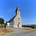 Church of Saint-Pierre in Cahan
 -
 Cahan village


- ^ "Répertoire national des élus: les maires". data.gouv.fr, Plateforme ouverte des données publiques françaises (in French). 9 August 2021.
- ^ "Populations légales 2021" (in French). The National Institute of Statistics and Economic Studies. 28 December 2023.
- ^ "Map of Suisse Normande" (PDF).
- ^ a b "Google Maps". Google Maps.
- ^ Population en historique depuis 1968, INSEE
| Authority control databases: National |
|---|
|
| This Orne geographical article is a stub. You can help Wikipedia by expanding it. |
Cahan | |
|---|---|
|
The bridge in Cahan | |
Cahan Cahan | |
| Coordinates: 48°51′35″N 0°26′31″W / 48.8597°N 0.4419°W | |
| Country | France |
| Region | Normandy |
| Department | Orne |
| Arrondissement | Argentan |
| Canton | Athis-Val de Rouvre |
| Intercommunality | CA Flers Agglo |
| Government | |
| • Mayor (2020–2026) | Xavier De Saint Pol [1] |
| Area 1 | 5.87 km2 (2.27 sq mi) |
| Population (2021)
[2] | 163 |
| • Density | 28/km2 (72/sq mi) |
| Time zone | UTC+01:00 ( CET) |
| • Summer ( DST) | UTC+02:00 ( CEST) |
| INSEE/Postal code |
61069 /61430 |
| Elevation | 50–242 m (164–794 ft) (avg. 140 m or 460 ft) |
| 1 French Land Register data, which excludes lakes, ponds, glaciers > 1 km2 (0.386 sq mi or 247 acres) and river estuaries. | |
Cahan is a commune in the Orne department in north-western France.
The commune is part of the area known as Suisse Normande. [3]
The commune is made up of the following collection of villages and hamlets, Fourneaux,La Bijude, Le Haut Vardon, Le Bas Vardon and Cahan. [4]
The commune has 2 watercourses running through it the river Noireau and 1 stream the Mare des Bois.
Neighbouring communes
[4] | |
|---|---|
| Year | Pop. | ±% p.a. |
|---|---|---|
| 1968 | 250 | — |
| 1975 | 205 | −2.80% |
| 1982 | 223 | +1.21% |
| 1990 | 211 | −0.69% |
| 1999 | 187 | −1.33% |
| 2007 | 203 | +1.03% |
| 2012 | 155 | −5.25% |
| 2017 | 181 | +3.15% |
| Source: INSEE [5] | ||
-
La mairie de Cahan
-
Church of Saint-Pierre in Cahan
-
Cahan village
- ^ "Répertoire national des élus: les maires". data.gouv.fr, Plateforme ouverte des données publiques françaises (in French). 9 August 2021.
- ^ "Populations légales 2021" (in French). The National Institute of Statistics and Economic Studies. 28 December 2023.
- ^ "Map of Suisse Normande" (PDF).
- ^ a b "Google Maps". Google Maps.
- ^ Population en historique depuis 1968, INSEE
| Authority control databases: National |
|---|
|
| This Orne geographical article is a stub. You can help Wikipedia by expanding it. |