Ménil-Gondouin | |
|---|---|
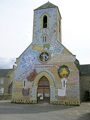
 The church in Ménil-Gondouin | |
| Coordinates: 48°45′19″N 0°17′33″W / 48.7553°N 0.2925°W | |
| Country | France |
| Region | Normandy |
| Department | Orne |
| Arrondissement | Argentan |
| Canton | Athis-Val de Rouvre |
| Intercommunality | Val d'Orne |
| Government | |
| • Mayor (2020–2026) | Pascal Bouquerel [1] |
| Area 1 | 9.17 km2 (3.54 sq mi) |
| Population (2021)
[2] | 160 |
| • Density | 17/km2 (45/sq mi) |
| Time zone | UTC+01:00 ( CET) |
| • Summer ( DST) | UTC+02:00 ( CEST) |
| INSEE/Postal code |
61265 /61210 |
| Elevation | 157–254 m (515–833 ft) (avg. 229 m or 751 ft) |
| 1 French Land Register data, which excludes lakes, ponds, glaciers > 1 km2 (0.386 sq mi or 247 acres) and river estuaries. | |
Ménil-Gondouin (French pronunciation: [menil ɡɔ̃dwɛ̃] ) is a commune in the Orne department in north-western France.
The commune is made up of the following collection of villages and hamlets, La Coconière, La Haute Bruyèreand Ménil-Gondouin. [3]
The commune is part of area known as Suisse Normande. [4]
Menil-Gondouin only has one watercourse running through it, the Ruisseau de Vienne.
Saint-Vigor du Ménil-Gondouin church is a nineteenth century church that has been covered in statues and dozens of inscriptions by a single person, the parish priest Victor Paysant (1841-1921). [5]
The church contains the head of a statue, of the Crowned Virgin, that is dating back to the 14th/15th Century and was listed as a Monument historique in 1984. [6]
-
One of the statues of the Church
-
Churches Pulpit
-
Victor Paysant
The Commune has 2 other buildings and areas listed as a Monument historique [4]
- Domain of the Court a set of remains of an old 16th century Chateau that belonged to Antoine de Turgot, that was listed as a Monument historique in 1983. [7]
- Logis Saint-Honorine an 18th Century chateau with outbuildings dating back to the 15th century, listed as Monument Historique in 1975 [8]
- ^ "Répertoire national des élus: les maires". data.gouv.fr, Plateforme ouverte des données publiques françaises (in French). 9 August 2021.
- ^ "Populations légales 2021" (in French). The National Institute of Statistics and Economic Studies. 28 December 2023.
- ^ a b "Ménil-Gondouin · 61210, France". Ménil-Gondouin · 61210, France.
- ^ a b "Map of Suisse Normande" (PDF).
- ^ "Eglise de Ménil-Gondouin". www.office-tourisme-putanges.com.
- ^ "Statue (tête) : Vierge couronnée". www.pop.culture.gouv.fr.
- ^ "Domaine de la Cour à Ménil-Gondouin - PA00110852". monumentum.fr.
- ^ "Logis Saint-Honorine à Ménil-Gondouin - PA00110853". monumentum.fr.
Ménil-Gondouin | |
|---|---|
 The church in Ménil-Gondouin | |
| Coordinates: 48°45′19″N 0°17′33″W / 48.7553°N 0.2925°W | |
| Country | France |
| Region | Normandy |
| Department | Orne |
| Arrondissement | Argentan |
| Canton | Athis-Val de Rouvre |
| Intercommunality | Val d'Orne |
| Government | |
| • Mayor (2020–2026) | Pascal Bouquerel [1] |
| Area 1 | 9.17 km2 (3.54 sq mi) |
| Population (2021)
[2] | 160 |
| • Density | 17/km2 (45/sq mi) |
| Time zone | UTC+01:00 ( CET) |
| • Summer ( DST) | UTC+02:00 ( CEST) |
| INSEE/Postal code |
61265 /61210 |
| Elevation | 157–254 m (515–833 ft) (avg. 229 m or 751 ft) |
| 1 French Land Register data, which excludes lakes, ponds, glaciers > 1 km2 (0.386 sq mi or 247 acres) and river estuaries. | |
Ménil-Gondouin (French pronunciation: [menil ɡɔ̃dwɛ̃] ) is a commune in the Orne department in north-western France.
The commune is made up of the following collection of villages and hamlets, La Coconière, La Haute Bruyèreand Ménil-Gondouin. [3]
The commune is part of area known as Suisse Normande. [4]
Menil-Gondouin only has one watercourse running through it, the Ruisseau de Vienne.
Saint-Vigor du Ménil-Gondouin church is a nineteenth century church that has been covered in statues and dozens of inscriptions by a single person, the parish priest Victor Paysant (1841-1921). [5]
The church contains the head of a statue, of the Crowned Virgin, that is dating back to the 14th/15th Century and was listed as a Monument historique in 1984. [6]
-
One of the statues of the Church
-
Churches Pulpit
-
Victor Paysant
The Commune has 2 other buildings and areas listed as a Monument historique [4]
- Domain of the Court a set of remains of an old 16th century Chateau that belonged to Antoine de Turgot, that was listed as a Monument historique in 1983. [7]
- Logis Saint-Honorine an 18th Century chateau with outbuildings dating back to the 15th century, listed as Monument Historique in 1975 [8]
- ^ "Répertoire national des élus: les maires". data.gouv.fr, Plateforme ouverte des données publiques françaises (in French). 9 August 2021.
- ^ "Populations légales 2021" (in French). The National Institute of Statistics and Economic Studies. 28 December 2023.
- ^ a b "Ménil-Gondouin · 61210, France". Ménil-Gondouin · 61210, France.
- ^ a b "Map of Suisse Normande" (PDF).
- ^ "Eglise de Ménil-Gondouin". www.office-tourisme-putanges.com.
- ^ "Statue (tête) : Vierge couronnée". www.pop.culture.gouv.fr.
- ^ "Domaine de la Cour à Ménil-Gondouin - PA00110852". monumentum.fr.
- ^ "Logis Saint-Honorine à Ménil-Gondouin - PA00110853". monumentum.fr.


