| Autovía A-70 | |
|---|---|
| Alicante ring road | |
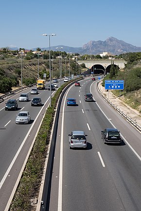
 A-70 highway and San Juan's tunnels | |
| Route information | |
| Part of
| |
| Length | 31 km (19 mi) |
| Major junctions | |
| From | El Campello |
|
J13 → Autovía A-77 J17 → Autovía A-31 J22 → Airport J30 →Elche | |
| To | Elche |
| Location | |
| Country | Spain |
| Highway system | |
|
| |
The Autovía A-70 is one of two beltways of Alicante, Spain. Specifically, it is the nearest beltway to the city and is a toll-free highway. Its length is about 31 km.
The A-70 begins at El Campello and ends at Elche, passing near Muchamiel, Alicante and San Vicente del Raspeig. The route belongs to the Spanish Ministry of Transport, Mobility and Urban Agenda. [1]
References
- ^ "Spanish Official Road Map" [Mapa Oficial de Carreteras]. mitma.gob.es (in Spanish). Spanish Ministry of Transport, Mobility and Urban Agenda. 2022. Retrieved 2 November 2022.
| Autovía A-70 | |
|---|---|
| Alicante ring road | |
 A-70 highway and San Juan's tunnels | |
| Route information | |
| Part of
| |
| Length | 31 km (19 mi) |
| Major junctions | |
| From | El Campello |
|
J13 → Autovía A-77 J17 → Autovía A-31 J22 → Airport J30 →Elche | |
| To | Elche |
| Location | |
| Country | Spain |
| Highway system | |
|
| |
The Autovía A-70 is one of two beltways of Alicante, Spain. Specifically, it is the nearest beltway to the city and is a toll-free highway. Its length is about 31 km.
The A-70 begins at El Campello and ends at Elche, passing near Muchamiel, Alicante and San Vicente del Raspeig. The route belongs to the Spanish Ministry of Transport, Mobility and Urban Agenda. [1]
References
- ^ "Spanish Official Road Map" [Mapa Oficial de Carreteras]. mitma.gob.es (in Spanish). Spanish Ministry of Transport, Mobility and Urban Agenda. 2022. Retrieved 2 November 2022.
