Photos • Location
You can help expand this article with text translated from
the corresponding article in Spanish. (November 2019) Click [show] for important translation instructions.
|
| Autovía A-35 | |
|---|---|
| Autovía Almansa-Xàtiva | |
 | |
| Route information | |
| Length | 44 km (27 mi) |
| Major junctions | |
| From | Almansa |
| To | Xàtiva |
| Location | |
| Country | Spain |
| Highway system | |
|
| |
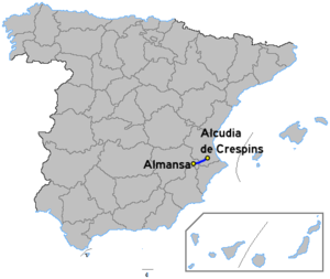
The Autovía A-35 (formerly known as the Almansa-Xàtiva highway) [1] is a highway in the province of Valencia, Spain.
It connects Xàtiva and the N-340/ CV-40 to Almansa and the N-330 otherwise known as the Autovía de Levante.
References
- ^ "Jefatura del Estado" (PDF). boe.es. 30 September 2015. Retrieved 29 July 2023.
You can help expand this article with text translated from
the corresponding article in Spanish. (November 2019) Click [show] for important translation instructions.
|
| Autovía A-35 | |
|---|---|
| Autovía Almansa-Xàtiva | |
 | |
| Route information | |
| Length | 44 km (27 mi) |
| Major junctions | |
| From | Almansa |
| To | Xàtiva |
| Location | |
| Country | Spain |
| Highway system | |
|
| |
The Autovía A-35 (formerly known as the Almansa-Xàtiva highway) [1] is a highway in the province of Valencia, Spain.
It connects Xàtiva and the N-340/ CV-40 to Almansa and the N-330 otherwise known as the Autovía de Levante.
References
- ^ "Jefatura del Estado" (PDF). boe.es. 30 September 2015. Retrieved 29 July 2023.
