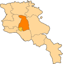
Photos • Location
40°18′42″N 44°44′56″E / 40.31167°N 44.74889°E
Zovashen
Զովաշեն | |
|---|---|
| Coordinates: 40°18′42″N 44°44′56″E / 40.31167°N 44.74889°E | |
| Country | Armenia |
| Marz (Province) | Kotayk |
| Elevation | 2,040 m (6,690 ft) |
| Population (2010) | |
| • Total | 168 |
| Time zone | UTC+4 ( ) |
Zovashen ( Armenian: Զովաշեն, formerly, Dallaklu) is a village in the Kotayk Province of Armenia. The village is overwhelmingly ethnic Armenian (86%) while the remaining population is Kurdish (14%) and the locals are mainly engaged in agriculture. [1]
See also
References
- ^ "Ակունք համայնքի Զովաշեն գյուղ" (in Armenian). Retrieved 20 May 2020.
- Zovashen, Kotayk at GEOnet Names Server
- Report of the results of the 2001 Armenian Census, Statistical Committee of Armenia

