Photos • Location

40°22′46″N 44°35′58″E / 40.37944°N 44.59944°E
Argel
Արգել | |
|---|---|
Village | |
 Argel Village | |
 Argel | |
| Coordinates: 40°22′46″N 44°35′58″E / 40.37944°N 44.59944°E | |
| Country | Armenia |
| Marz (Province) | Kotayk |
| Elevation | 1,428 m (4,685 ft) |
| Population (2008) | |
| • Total | 2,745 |
| Time zone | UTC+4 ( ) |
Argel ( Armenian: Արգել), formerly Lusakert ( Armenian: Լուսակերտ), is a village in the Kotayk Province of Armenia.
Gallery
-
 S. Gevorg Church built in 1890.
 -
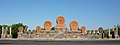 "Christian Armenia" memorial in Argel
 -
 Hrazdan River Gorge and Argel Village (left)
 -
Argel village, view from above


See also
References
- Argel, Armenia at GEOnet Names Server
- World Gazeteer: Armenia[ dead link] – World-Gazetteer.com
- Report of the results of the 2001 Armenian Census, Statistical Committee of Armenia

|
| This article about a location in Kotayk Province, Armenia is a stub. You can help Wikipedia by expanding it. |
40°22′46″N 44°35′58″E / 40.37944°N 44.59944°E
Argel
Արգել | |
|---|---|
Village | |
|
Argel Village | |
Argel | |
| Coordinates: 40°22′46″N 44°35′58″E / 40.37944°N 44.59944°E | |
| Country | Armenia |
| Marz (Province) | Kotayk |
| Elevation | 1,428 m (4,685 ft) |
| Population (2008) | |
| • Total | 2,745 |
| Time zone | UTC+4 ( ) |
Argel ( Armenian: Արգել), formerly Lusakert ( Armenian: Լուսակերտ), is a village in the Kotayk Province of Armenia.
Gallery
-
S. Gevorg Church built in 1890.
-
"Christian Armenia" memorial in Argel
-
Hrazdan River Gorge and Argel Village (left)
-
Argel village, view from above
See also
References
- Argel, Armenia at GEOnet Names Server
- World Gazeteer: Armenia[ dead link] – World-Gazetteer.com
- Report of the results of the 2001 Armenian Census, Statistical Committee of Armenia
|
| This article about a location in Kotayk Province, Armenia is a stub. You can help Wikipedia by expanding it. |