Zell im Fichtelgebirge | |
|---|---|
 Market square | |
 Coat of arms | |
Location of Zell im Fichtelgebirge within Hof district 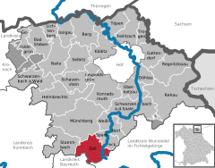 | |
 Zell im Fichtelgebirge  Zell im Fichtelgebirge | |
| Coordinates: 50°7′N 11°48′E / 50.117°N 11.800°E | |
| Country | Germany |
| State | Bavaria |
| Admin. region | Oberfranken |
| District | Hof |
| Government | |
| • Mayor (2020–26) | Horst Penzel [1] |
| Area | |
| • Total | 31.24 km2 (12.06 sq mi) |
| Elevation | 615 m (2,018 ft) |
| Population (2022-12-31)
[2] | |
| • Total | 1,866 |
| • Density | 60/km2 (150/sq mi) |
| Time zone | UTC+01:00 ( CET) |
| • Summer ( DST) | UTC+02:00 ( CEST) |
| Postal codes | 95239 |
| Dialling codes | 09257 |
| Vehicle registration | HO |
| Website | www.markt-zell.de |
Zell im Fichtelgebirge, formerly Zell (official name until July 2007) [3] is a market town in the district of Hof in Bavaria in Germany.
Geography
The heart of the market parish lies between the towns of Hof and Bayreuth, about 5 km from the B 2 federal road and about 10 km from the A 9 motorway. The River Saale rises on the Waldstein ridge in the Fichtel Mountains near Zell im Fichtelgebirge. The surrounding area may explored on some 30 kilometres of signposted hiking trails.
References
- ^ Liste der ersten Bürgermeister/Oberbürgermeister in kreisangehörigen Gemeinden, Bayerisches Landesamt für Statistik, 15 July 2021.
- ^ Genesis Online-Datenbank des Bayerischen Landesamtes für Statistik Tabelle 12411-003r Fortschreibung des Bevölkerungsstandes: Gemeinden, Stichtag (Einwohnerzahlen auf Grundlage des Zensus 2011).
- ^ "Seit gestern Abend amtlich: Zell im Fichtelgebirge" (in German). Frankenpost. 2007-07-16. Retrieved 2007-08-02.
Towns and municipalities in
Hof (district) | ||
|---|---|---|
|  | |
| International | |
|---|---|
| National | |
|
| This Hof district location article is a stub. You can help Wikipedia by expanding it. |
Zell im Fichtelgebirge | |
|---|---|
|
Market square | |
|
Coat of arms | |
Location of Zell im Fichtelgebirge within Hof district | |
Zell im Fichtelgebirge Zell im Fichtelgebirge | |
| Coordinates: 50°7′N 11°48′E / 50.117°N 11.800°E | |
| Country | Germany |
| State | Bavaria |
| Admin. region | Oberfranken |
| District | Hof |
| Government | |
| • Mayor (2020–26) | Horst Penzel [1] |
| Area | |
| • Total | 31.24 km2 (12.06 sq mi) |
| Elevation | 615 m (2,018 ft) |
| Population (2022-12-31)
[2] | |
| • Total | 1,866 |
| • Density | 60/km2 (150/sq mi) |
| Time zone | UTC+01:00 ( CET) |
| • Summer ( DST) | UTC+02:00 ( CEST) |
| Postal codes | 95239 |
| Dialling codes | 09257 |
| Vehicle registration | HO |
| Website | www.markt-zell.de |
Zell im Fichtelgebirge, formerly Zell (official name until July 2007) [3] is a market town in the district of Hof in Bavaria in Germany.
Geography
The heart of the market parish lies between the towns of Hof and Bayreuth, about 5 km from the B 2 federal road and about 10 km from the A 9 motorway. The River Saale rises on the Waldstein ridge in the Fichtel Mountains near Zell im Fichtelgebirge. The surrounding area may explored on some 30 kilometres of signposted hiking trails.
References
- ^ Liste der ersten Bürgermeister/Oberbürgermeister in kreisangehörigen Gemeinden, Bayerisches Landesamt für Statistik, 15 July 2021.
- ^ Genesis Online-Datenbank des Bayerischen Landesamtes für Statistik Tabelle 12411-003r Fortschreibung des Bevölkerungsstandes: Gemeinden, Stichtag (Einwohnerzahlen auf Grundlage des Zensus 2011).
- ^ "Seit gestern Abend amtlich: Zell im Fichtelgebirge" (in German). Frankenpost. 2007-07-16. Retrieved 2007-08-02.
Towns and municipalities in
Hof (district) | ||
|---|---|---|
| | |
| International | |
|---|---|
| National | |
|
| This Hof district location article is a stub. You can help Wikipedia by expanding it. |