This article relies largely or entirely on a
single source. (February 2017) |
Záhony District
Záhonyi járás | |
|---|---|
 Coat of arms | |
 Záhony District within Hungary and Szabolcs-Szatmár-Bereg County. | |
| Country | |
| County | Szabolcs-Szatmár-Bereg |
| District seat | Záhony |
| Area | |
| • Total | 145.95 km2 (56.35 sq mi) |
| • Rank | 13th in Szabolcs-Szatmár-Bereg |
| Population (2011 census) | |
| • Total | 18,963 |
| • Rank | 12th in Szabolcs-Szatmár-Bereg |
| • Density | 130/km2 (300/sq mi) |
Záhony ( Hungarian: Záhonyi járás) is a district in northern part of Szabolcs-Szatmár-Bereg County. Záhony is also the name of the town where the district seat is found. The district is located in the Northern Great Plain Statistical Region. This district is a part of Rétköz geographical region.
Geography
Záhony District borders with the Ukrainian oblast of Zakarpattia to the northeast, Vásárosnamény District to the southeast, Kisvárda District to the south, Cigánd District ( Borsod-Abaúj-Zemplén County) to the west, the Slovakian region of Košice to the northwest. The number of the inhabited places in Záhony District is 11.
Municipalities
The district has 2 towns, 1 large village and 8 villages. (ordered by population, as of 1 January 2013) [1]
- Benk (440)
- Eperjeske (1,217)
- Győröcske (124)
- Komoró (1,289)
- Mándok (4,247)
- Tiszabezdéd (1,925)
- Tiszamogyorós (687)
- Tiszaszentmárton (1,151)
- Tuzsér (3,418)
- Záhony (4,125) – district seat
- Zsurk (746)
The bolded municipalities are cities, italics municipality is large village.
Demographics
Religion in Záhony District (2011 census)
In 2011, it had a population of 18,963 and the population density was 130/km2.
| Year | County population [2] | Change |
|---|---|---|
| 2011 | 18,963 | n/a |
Ethnicity
Besides the Hungarian majority, the main minorities are the Roma (approx. 2,500) and Ukrainian (100).
Total population (2011 census): 18,963
Ethnic groups (2011 census):
[3] Identified themselves: 19,372 persons:
- Hungarians: 16,689 (86.15%)
- Gypsies: 2,420 (12.49%)
- Others and indefinable: 263 (1.36%)
Approx. 500 persons in Záhony District did declare more than one ethnic group at the 2011 census.
Religion
Religious adherence in the county according to 2011 census: [4]
- Reformed – 10,635;
- Catholic – 3,499 ( Roman Catholic – 2,401; Greek Catholic – 1,098);
- other religions – 426;
- Non-religious – 725;
- Atheism – 39;
- Undeclared – 3,639.
Gallery
-
 Záhony, the district seat
 -
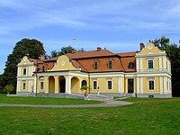 Lónyay Mansion in Tuzsér
 -
 Záhony Railway Freight Terminal
 -
 Greek Catholic Church in Mándok


See also
References
- ^ A KSH 2013. évi helységnévkönyve
- ^ népesség.com, "Záhonyi járás népessége"
- ^ 4.1.6.1 A népesség nemzetiség szerint, 2011, (in Hungarian) [1]
- ^ 4.1.7.1 A népesség vallás, felekezet szerint, 2011, (in Hungarian) [2]
External links
| Towns (2) | ||
|---|---|---|
| Large village (1) | ||
| Villages (8) | ||
48°24′17″N 22°10′37″E / 48.40478454372°N 22.17691832478836°E
|
| This Szabolcs-Szatmár-Bereg location article is a stub. You can help Wikipedia by expanding it. |
This article relies largely or entirely on a
single source. (February 2017) |
Záhony District
Záhonyi járás | |
|---|---|
|
Coat of arms | |
|
Záhony District within Hungary and Szabolcs-Szatmár-Bereg County. | |
| Country | |
| County | Szabolcs-Szatmár-Bereg |
| District seat | Záhony |
| Area | |
| • Total | 145.95 km2 (56.35 sq mi) |
| • Rank | 13th in Szabolcs-Szatmár-Bereg |
| Population (2011 census) | |
| • Total | 18,963 |
| • Rank | 12th in Szabolcs-Szatmár-Bereg |
| • Density | 130/km2 (300/sq mi) |
Záhony ( Hungarian: Záhonyi járás) is a district in northern part of Szabolcs-Szatmár-Bereg County. Záhony is also the name of the town where the district seat is found. The district is located in the Northern Great Plain Statistical Region. This district is a part of Rétköz geographical region.
Geography
Záhony District borders with the Ukrainian oblast of Zakarpattia to the northeast, Vásárosnamény District to the southeast, Kisvárda District to the south, Cigánd District ( Borsod-Abaúj-Zemplén County) to the west, the Slovakian region of Košice to the northwest. The number of the inhabited places in Záhony District is 11.
Municipalities
The district has 2 towns, 1 large village and 8 villages. (ordered by population, as of 1 January 2013) [1]
- Benk (440)
- Eperjeske (1,217)
- Győröcske (124)
- Komoró (1,289)
- Mándok (4,247)
- Tiszabezdéd (1,925)
- Tiszamogyorós (687)
- Tiszaszentmárton (1,151)
- Tuzsér (3,418)
- Záhony (4,125) – district seat
- Zsurk (746)
The bolded municipalities are cities, italics municipality is large village.
Demographics
Religion in Záhony District (2011 census)
In 2011, it had a population of 18,963 and the population density was 130/km2.
| Year | County population [2] | Change |
|---|---|---|
| 2011 | 18,963 | n/a |
Ethnicity
Besides the Hungarian majority, the main minorities are the Roma (approx. 2,500) and Ukrainian (100).
Total population (2011 census): 18,963
Ethnic groups (2011 census):
[3] Identified themselves: 19,372 persons:
- Hungarians: 16,689 (86.15%)
- Gypsies: 2,420 (12.49%)
- Others and indefinable: 263 (1.36%)
Approx. 500 persons in Záhony District did declare more than one ethnic group at the 2011 census.
Religion
Religious adherence in the county according to 2011 census: [4]
- Reformed – 10,635;
- Catholic – 3,499 ( Roman Catholic – 2,401; Greek Catholic – 1,098);
- other religions – 426;
- Non-religious – 725;
- Atheism – 39;
- Undeclared – 3,639.
Gallery
-
Záhony, the district seat
-
Lónyay Mansion in Tuzsér
-
Záhony Railway Freight Terminal
-
Greek Catholic Church in Mándok
See also
References
- ^ A KSH 2013. évi helységnévkönyve
- ^ népesség.com, "Záhonyi járás népessége"
- ^ 4.1.6.1 A népesség nemzetiség szerint, 2011, (in Hungarian) [1]
- ^ 4.1.7.1 A népesség vallás, felekezet szerint, 2011, (in Hungarian) [2]
External links
| Towns (2) | ||
|---|---|---|
| Large village (1) | ||
| Villages (8) | ||
48°24′17″N 22°10′37″E / 48.40478454372°N 22.17691832478836°E
|
| This Szabolcs-Szatmár-Bereg location article is a stub. You can help Wikipedia by expanding it. |