This page has archives. Sections older than 1458.5 days may be automatically archived by ClueBot III.
You can request maps on this page. Your request will then be handled by a participant of the maps department. Instructions and guidelines are provided below. Requests will typically be handled by a member of the maps department; however, they can be completed by anyone willing to take on the request.
Guidelines
If you can create a KML file for the article, please do so, and note the existence of the KML in your request. KML files can be imported into GIS software, which may significantly expedite your request.
Please be respectful. There is a limit of one requested map per editor and 5 requested maps per state at any time. This is to give the map creators enough time to create the requested maps while working at their own pace and leisure. Please do not request another map until previous requests have closed unless:
The additional requests are the result of a
GAN,
FAC, or
ACR reviewer holding or opposing an article in one of those venues over the lack of a map or
One month has passed since the request was filed.
Any additional requests that do not meet either of these criteria will be removed.
We ask that articles be improved to the "B-Class" assessment level before requesting a map. You may request a map for any article, but articles that are B-Class or higher will have their request expedited.
Requests for articles assessed as Stub-Class will be removed after three months if it has not been filled and the article has not been improved to at least Start-Class by that time.
Requesting a new map
Click the map request link at the bottom of this table.
Enter the article's class
Type in "New map" in the action required box
Leave a short blurb regarding your request in the comments section, such as any special instructions for the cartographer. At the end of your comments, please
sign.
Make note if there is a KML file and link to it
Save the page.
Requesting a corrected map
Click the map request link at the bottom of this table.
Enter the article's class
Type in "Correction to existing map" in the action required box
Link to the map like this [[:File:<link to map>]]. Leave a short blurb explaining what is wrong with the map in the comments section. At the end of your comments, please
sign.
Make note if there is a KML file and link to it
Save the page.
Completing a request
To accept a request, please do so by typing '''Accepted''' in your response to the request or simply make the map.
To decline a request, mark the request with {{
Not done}} and explain why the file was not made.
Upload all files to Commons and post in the appropriate section below with {{done}} [[:File:<link to map>]] ~~~~.
If a request is resolved and {{
Done}} or {{
Not done}} are not applicable, mark it with {{User:ClueBot III/ArchiveNow}}
Comments: Per
this source (page 17-18), I-74 will meet with NC 211 at the border with Columbus and Brunswick Counties. The Interstate will then follow Hickman Road to the SC border along the future extension of the Carolina Bays Parkway (map provided on both pages of the PDF document). Thanks and have a good day!
DiscoA340 (
talk) 21:34, 29 January 2023 (UTC)reply
Also, after the map was fixed due to some glitches, a small section of map data was removed near Exit 196 on I-40 and near Exit 56 on the current route for I-74. A small concurrency with Interstate 40 was also added to the map which I don't believe exists. How it originally looked can been seen on
Data:Interstate 74 in North Carolina.map southeast of Winston-Salem. If that section could be fixed as well, that would be great. Thank you for your time and have a great day!
DiscoA340 (
talk) 23:06, 23 May 2023 (UTC)reply
Comments: While the western portion of the map was traced using a road map overlay, the eastern section was not. I was able to manually add a few point to the map, but it lacks in quality compared to the western portion. If someone could trace that section, I would greatly appreciate it. A map of the bypass can be found on the
NCDOT's STIP Map, though it requires you zoom to the project. If that doesn't work as a source, I found
this image which shows the eastern half of the bypass. Thank you for your time and have a great day!
DiscoA340 (
talk) 02:06, 26 May 2023 (UTC)reply
Comments: The map does not load. This is my first KML file, so I am not fully familiar with the file format.Speed doesn't always mean quality400Weir (
talk)
@
400Weir: the KML isn't sufficient on its own to create the map in an infobox. It needs to be converted to a GeoJSON file for {{
maplink-road}} to work. I'm not sure if {{
infobox street}} supports that style of map. {{
Infobox road}} is the wrong infobox for that roadway because it's not a state highway. That article also falls outside of the scope of this project. Please note, due to wiki politics, much of this project's activity is winding down as the membership moves over to the
AARoads Wiki. Imzadi 1979→ 15:04, 19 September 2023 (UTC)reply
Understood, I'll make the necessary corrections. Thank you. Speed doesn't always mean quality400Weir (
talk) 16:56, 19 September 2023 (UTC)reply
Adding just {{
maplink-road}} to the infobox won't call up a map on its own unless an OpenStreetMap relation is included in the Wikidata entry for the article. Otherwise, you need to add the name of the GeoJSON file to the template to get it to draw the line on the base map. Imzadi 1979→ 03:01, 20 September 2023 (UTC)reply
It is decommissioned though, why is it necessary? --
WashuOtaku (
talk) 20:56, 7 January 2024 (UTC)reply
Plenty of decommissioned routes such as
U.S. Route 66,
U.S. Route 111,
U.S. Route 410, and
U.S. Route 466 have interactive maps while US 99 does not. Also, many of those routes also have KML files, and US 99 doesn't have any. I just find it odd I guess, but I understand that it's really difficult to make maps based on former routes. So if it's not possible to make one for US 99, it's fine. ~ Sandy14156(
Talk ✉️) 00:58, 8 January 2024 (UTC)reply
That's fine, I was curious is all. I don't make the files either, but it probably be best to identify what version you are specifically asking for. Like are you asking what US 99 was before its decommission in 1972, at its start, or some sort of blend of all variations (would be very colorful)? --
WashuOtaku (
talk) 01:06, 8 January 2024 (UTC)reply
I'd rather have a map before its decommission, since I'd imagine it's easier than trying to get all of its variations. ~ Sandy14156(
Talk ✉️) 00:22, 9 January 2024 (UTC)reply
 Map Requests
 Click here to request a new map.
 C-Class article
 Stub-Class article
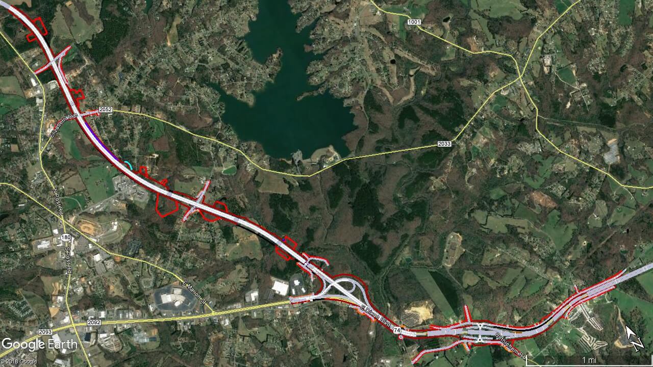
 Start-Class article