| This page is an archive of past discussions. Do not edit the contents of this page. If you wish to start a new discussion or revive an old one, please do so on the current talk page. |
Khuzestan
See Khuzestan conflict article, your additions are welcome. Greyshark09 ( talk) 12:22, 26 May 2013 (UTC)
Ba'ath Egypt
This source directly refers to the Ba'ath Party of Assem Qanso in Egypt, and its relations to Syria, they have nothing to do with the Iraqi Ba'ath movement.. A Syrian Ba'ath chapter does exist in Egypt, but as you well know, the Iraqi movement has historically been more active and more popular in other Arab countries. Of course, the chapter may have dissolved or become inactive by this time, or its just very small. -- TIAYN ( talk) 14:43, 5 July 2013 (UTC)
- I understand completely... I've tried but failed to find any information on some information on the Iraqi and Syrian Ba'ath Party in Palestine... As you may know the Arab Liberation Front and As-Sa'iqa are only front groups, and not the actual party organizations... -- TIAYN ( talk) 15:03, 5 July 2013 (UTC)
- Since you created the page, you may be interested in the fact that Fawzi Mutlaq al-Rawi is no longer Regional Secretary of the Iraqi Ba'ath... I have no idea when it happened, but Mouteb Shenan apparently is the new leader.... :) -- TIAYN ( talk) 13:10, 10 July 2013 (UTC)
Latakia offensive
Just wanted to say that your map looks great, but you need to color Jisr al-Shugur in the upper right corner as government territory because the town has been confirmed for some time to be government-held. Otherwise, nice work! EkoGraf ( talk) 16:47, 21 August 2013 (UTC)
- You can verify the info on this at Cities and towns during the Syrian civil war, but from the reliable news sources I've seen and the article I pointed out for you the whole town is at the moment government-held as well as one other smaller town just to the northeast of it. So in essence at least the immediate area in and arround Jisr al-Shugur is at the moment under government control. EkoGraf ( talk) 07:47, 22 August 2013 (UTC)
Hi, I just wanted to add to the praise for the map. Are you planning on doing any more maps like it? Esn ( talk) 10:38, 23 August 2013 (UTC)
Deir Ezzor Map
Rebels took the entire island Hawiqa is situated on. http://www.reuters.com/article/2013/08/20/us-syria-crisis-east-idUSBRE97J0P520130820 Sopher99 ( talk) 11:16, 24 August 2013 (UTC)
- Cool thanks. I'll update the map! MrPenguin20 ( talk) 11:20, 24 August 2013 (UTC)
The army hit rebel forces in Hawiqa district on Tuesday with tanks and multiple rocket launchers, and also battled them in territory separating Hawiqa from the district of Joura, opposition sources in the city said. The regime is trying to regain Hawiqa because it cannot afford the rebels to be so close to its most important stronghold of Joura and the army camp there, said Abu al-Tayyeb al-Deiri of the opposition Deir al-Zor Media Centre. http://www.reuters.com/article/2013/08/20/us-syria-crisis-east-idUSBRE97J0P520130820 95.134.222.207 ( talk) 09:36, 2 September 2013 (UTC)
- Thanks. I'll update the map to show the new government offensive. MrPenguin20 ( talk) 09:37, 2 September 2013 (UTC)
Thank you for making a map for Deir ez-Zor city. It was long overdue. I have a few suggestions:
1-
Sina'a neighbourhood should be blue because the article (
Deir ez-Zor clashes (2011–present)) says: “On 13 August, … 4 rebels killed by clashes in … Sina'a neighbourhoods.” Clashes happen there on a regular basis...
2-
Jebaylah neighbourhood should be labeled because it is mentioned by the article (same sentence as above) and it is often mentioned by the media as an important clash spot. You already have it in blue west of Hamidiyah.
3-
al-Rashdiya neighbourhood should be blue because the article says: “On 14 June, ... Clashes are taking place between rebel and regular forces in … al-Rashdiya neighbourhood ...” It is still the case today…
4-
Al-Qussour neighbourhood should be labeled because it is an important government stronghold. By the way, you have the label “Dumar” below “Joura”, however, it is not on Wikimapia and I have never heard of it...
Tradedia (
talk) 03:43, 8 September 2013 (UTC)
- Thanks! I've just uploaded a new map fixing the mistakes you mentioned. Let me know if you spot any other problems! MrPenguin20 ( talk) 14:09, 15 September 2013 (UTC)
Hama offensive MAP
Hi, I just saw your map of the province of Hama, again, it's a good job ;) But when this offensive, the Hama-Khan Shaykhun highway was under the control of the army. The town of Khan Shaykhun and its surroundings are also controlled by the army. And during this offensive, the army to keep control of Taybat al-Imam and the army took control of Halfaya ;) Rogal Dorm ( talk) 20:29, 6 September 2013 (UTC)
- I just saw this map concerned the first Hama offensive, sorry. The only thing to change is then Hama-Khan Shaykhun highway under military control, and Khan Shaykhun controlled by the army ;) Sorry :s Rogal Dorm ( talk) 20:42, 6 September 2013 (UTC)
- No that's great actually! I was actually planning on making a map showing the 2nd offensive, and so any information is much appreciated! I'll get started on fixing the map/uploading the one showing the 2nd offensive.
MrPenguin20 (
talk) 20:51, 6 September 2013 (UTC)
- Updated the map. How does that look?
MrPenguin20 (
talk) 21:08, 6 September 2013 (UTC)
- I think That the east of Khan Shaykhun is under the control of the army because as you can see here
[1], there is a military base (al khazanat), not attacked and still under military control. It is possible to make it appear on the map ?
Rogal Dorm (
talk) 21:37, 6 September 2013 (UTC)
- Well spotted! There is a small army base to the immediate south east of Khan Shaykhun and north of Murik; I guess that must be it? MrPenguin20 ( talk) 21:47, 6 September 2013 (UTC)
- Updated now.
MrPenguin20 (
talk) 22:01, 6 September 2013 (UTC)
- Yes ;) For Al tamanan'a, directly east of the base, I find this <redacted due to spam blacklisting of the URL>.This site information said that the city was taken by the army in 2012, and since then, there is nothing new coming from this city. I think we can be considered under the control of the army until there is no evidence to the contrary. So we can conclude that the east of Khan Shaykhun is controlled by the army. What do you think?
Rogal Dorm (
talk) 22:06, 6 September 2013 (UTC)
- Maybe. I might have missed a bit referring to government control of the village, but the site seems to me to mostly refer to the operations as raids being conducted from neighboring Alawite villages, suggesting the government isn't in control, but instead just sometimes makes forays into such villages (resulting in clashes). I think these operations are the same ones referenced in
this article, where again they're just referred to as raids. Although even if it's just raids being conducted against the town, I'd say it probably still merits moving the frontline a little bit closer to al-Tamana.
MrPenguin20 (
talk) 22:27, 6 September 2013 (UTC)
- I agree with the current map
Rogal Dorm (
talk) 22:45, 6 September 2013 (UTC)
- Cool, I'll get started on a map of the 2013 Offensive.
MrPenguin20 (
talk) 22:48, 6 September 2013 :::::::::: ;) Okay. You think it should show on the map the Hama military airport ? And all military bases ?
Rogal Dorm (
talk) 22:52, 6 September 2013 (UTC) Yeah, good idea!
MrPenguin20 (
talk) 22:57, 6 September 2013 (UTC)
- There is Hama military airport, and military zones south of Hama along the highway, a military base is glued to Hama southeast. And a military field north of Khattab. Another military area northeast of Hama. You see others that can put on the map? Rogal Dorm ( talk) 23:13, 6 September 2013 (UTC)
- Cool, I'll get started on a map of the 2013 Offensive.
MrPenguin20 (
talk) 22:48, 6 September 2013 :::::::::: ;) Okay. You think it should show on the map the Hama military airport ? And all military bases ?
Rogal Dorm (
talk) 22:52, 6 September 2013 (UTC) Yeah, good idea!
MrPenguin20 (
talk) 22:57, 6 September 2013 (UTC)
- I agree with the current map
Rogal Dorm (
talk) 22:45, 6 September 2013 (UTC)
- Maybe. I might have missed a bit referring to government control of the village, but the site seems to me to mostly refer to the operations as raids being conducted from neighboring Alawite villages, suggesting the government isn't in control, but instead just sometimes makes forays into such villages (resulting in clashes). I think these operations are the same ones referenced in
this article, where again they're just referred to as raids. Although even if it's just raids being conducted against the town, I'd say it probably still merits moving the frontline a little bit closer to al-Tamana.
MrPenguin20 (
talk) 22:27, 6 September 2013 (UTC)
- Yes ;) For Al tamanan'a, directly east of the base, I find this <redacted due to spam blacklisting of the URL>.This site information said that the city was taken by the army in 2012, and since then, there is nothing new coming from this city. I think we can be considered under the control of the army until there is no evidence to the contrary. So we can conclude that the east of Khan Shaykhun is controlled by the army. What do you think?
Rogal Dorm (
talk) 22:06, 6 September 2013 (UTC)
- I think That the east of Khan Shaykhun is under the control of the army because as you can see here
[1], there is a military base (al khazanat), not attacked and still under military control. It is possible to make it appear on the map ?
Rogal Dorm (
talk) 21:37, 6 September 2013 (UTC)
- Updated the map. How does that look?
MrPenguin20 (
talk) 21:08, 6 September 2013 (UTC)
- No that's great actually! I was actually planning on making a map showing the 2nd offensive, and so any information is much appreciated! I'll get started on fixing the map/uploading the one showing the 2nd offensive.
MrPenguin20 (
talk) 20:51, 6 September 2013 (UTC)
- Thanks! I'll upload the updated maps (including this, the 2nd Hama Offensive, and the Rif Dimashq Offensive) at the weekend (would have done so before, but been really busy this week). In the meantime though if anything else changes or you notice any other problems then naturally feel free to post it and it'll be fixed for the new versions :) MrPenguin20 ( talk)
2nde Hama offensive (2013)
To illustrate this offensive will require a any map of the province of Hama ;) Rogal Dorm ( talk) 13:14, 7 September 2013 (UTC)
- Yeah, do you think I'll need to make a bigger map showing the whole province for this offensive considering so much of it happens further to the east?
MrPenguin20 (
talk) 14:55, 15 September 2013 (UTC)
- It should a map showing the whole province ;)
Rogal Dorm (
talk) 16:12, 15 September 2013 (UTC)
- Are you ready ? :)
Rogal Dorm (
talk) 16:29, 26 September 2013 (UTC)
- Ok I've uploaded a provisional version to the page for now - none of the towns South East of Salamiyah are named at the moment however, so I'll need to fix that.
MrPenguin20 (
talk) 15:25, 27 September 2013 (UTC)
- Ok ;)
- Ok I've uploaded a provisional version to the page for now - none of the towns South East of Salamiyah are named at the moment however, so I'll need to fix that.
MrPenguin20 (
talk) 15:25, 27 September 2013 (UTC)
- Are you ready ? :)
Rogal Dorm (
talk) 16:29, 26 September 2013 (UTC)
- It should a map showing the whole province ;)
Rogal Dorm (
talk) 16:12, 15 September 2013 (UTC)
1- Taybat al-Imam is under army control
[2]
2- You want to write all the towns captured by the army ? I can find the names ;)
Rogal Dorm (
talk) 22:15, 27 September 2013 (UTC)
- Oops can't believe I missed Taybat al-Imam! I've added the names of a bunch of the villages in the South East to the new version, but yeah if there's towns of interest or anything that I've missed then please say :).
MrPenguin20 (
talk) 00:45, 28 September 2013 (UTC)
- For me, the map is good now ;)
Rogal Dorm (
talk) 00:28, 29 September 2013 (UTC)
- Great! I'll get started on a map for the
2nd Rif Dimashq offensive.
MrPenguin20 (
talk) 01:37, 29 September 2013 (UTC)
- Ok ;) Rogal Dorm ( talk) 09:17, 29 September 2013 (UTC)
- Great! I'll get started on a map for the
2nd Rif Dimashq offensive.
MrPenguin20 (
talk) 01:37, 29 September 2013 (UTC)
- For me, the map is good now ;)
Rogal Dorm (
talk) 00:28, 29 September 2013 (UTC)
- Oops can't believe I missed Taybat al-Imam! I've added the names of a bunch of the villages in the South East to the new version, but yeah if there's towns of interest or anything that I've missed then please say :).
MrPenguin20 (
talk) 00:45, 28 September 2013 (UTC)
Rif Dimashq offensive map
The M5 highway was under the control of the army before the attack, so that Daraya and Moadamyeh are completely surrounded. Like for the highway M1, Douma is completely surrounded Rogal Dorm ( talk) 13:22, 7 September 2013 (UTC)
- Here are several other information:
1- At the east of the M5 highway Al-Sabinah and Hujayrah are contested like Deir Salman, Yalda, Babbila and Beit sahem, Hatitat al-Turkuman and Deir al-Asafir, all this city attacked by the army
[3]
2- Qadam also contested, the west is controlled by the army and the east is controled by the rebels, the "border" is the rapid way.
I have more information, but I do not have time now
Rogal Dorm (
talk) 16:46, 14 September 2013 (UTC)
Yalda under the full control of the Syrian army! And army captured the city Deir Salman. http://www.elnashra.com/news/show/659876 37.55.213.139 ( talk) 19:44, 14 September 2013 (UTC)
- Updated - thoughts?
MrPenguin20 (
talk) 13:45, 15 September 2013 (UTC)
- Good job ;)
- Updated - thoughts?
MrPenguin20 (
talk) 13:45, 15 September 2013 (UTC)
1- Is it possible to show on the map: The Adra prison (Under Army control), The Marj As Sultan Air Base (Under Rebel control), The siege of "Brigade 39" (Under Army control), the siege of Brigade 22 (Under Army control), the base of the Special Forces (Under Army control, betwen Harasta and Qaboun), the Mezzeh military airport (Under Army control), the base of the 4th Division (Under Army control), the siege of the Republican Guard Brigade (Under Army control) and the base of Al-Drejj (Under Army control, in the north of Jamraya). It's possible ?
[4]
2- Daraya is contested
Rogal Dorm (
talk) 16:10, 15 September 2013 (UTC)
- Shebaa in under army control Rogal Dorm ( talk) 20:10, 22 September 2013 (UTC)
- Updated now, although I'm not sure if the 22 Brigade base is marked correctly. Btw I'm working on maps for the Damascus offensives atm, and I've uploaded one for the
February 2013 offensive. It look about right?
MrPenguin20 (
talk) 00:30, 23 September 2013 (UTC)
- According to reports, the rebels have not taken this base. This base allowed the army to protect the south of Adra because rebels fighter arrived by the desert. For other map, I'll look later ;) Rogal Dorm ( talk) 11:38, 23 September 2013 (UTC)
- Updated now, although I'm not sure if the 22 Brigade base is marked correctly. Btw I'm working on maps for the Damascus offensives atm, and I've uploaded one for the
February 2013 offensive. It look about right?
MrPenguin20 (
talk) 00:30, 23 September 2013 (UTC)
Syrian army controls Najhah. http://www.dailystar.com.lb/News/Middle-East/2013/Oct-01/233135-rights-group-finds-mass-graves-near-damascus.ashx#axzz2gTvJasaY 92.113.218.45 ( talk) 16:13, 1 October 2013 (UTC)
- Thanks! I think it might already be marked as being under SAA control though (although not labeled) - Najha's just slightly due east of the Sahya Mountains military base. MrPenguin20 ( talk) 16:21, 1 October 2013 (UTC)
Rif Dimashq offensive (March 2013–present)
I am considering if we should close the article Rif Dimashq offensive (March 2013–present) as a Partial Syrian Army victory or just Syrian Army victory, due to the fact that for two weeks all offensive operations by the Army ceased after the gas attacks and during the threat of air-strikes by the West. Before that for five months all operations by the military were continues. If major offensive operations by ether side are launched once again we open up a new article. Would you agree? EkoGraf ( talk) 12:29, 15 September 2013 (UTC)
- Sounds about right to me. MrPenguin20 ( talk) 12:35, 15 September 2013 (UTC)
to agree! Here is a map of the situation around Damascus https://upload.wikimedia.org/wikipedia/commons/6/68/Military_situation_in_Damascus_region_as_of_15th_of_September_2013.png — Preceding unsigned comment added by 95.134.192.148 ( talk) 13:01, 15 September 2013 (UTC)
- Be careful, someone change the card with the events that occurred after the end of the offensive, would you return to the map before? I will create an article this week for the new offensive Rogal Dorm ( talk) 15:23, 16 October 2013 (UTC)
Damascus offensive (2013) Map
This map is good ! Congratulations ! Just the Adra prison has not been captured by the rebels and Yarmouk was under rebel control since the previous rebel offensive Rogal Dorm ( talk) 18:29, 23 September 2013 (UTC)
Shebaa and Dair Salman now under the full control of the army http://en.wikipedia.org/wiki/Template:Syrian_civil_war_detailed_map http://www.presstv.ir/detail/2013/09/19/324913/syria-army-continues-mopup-ops/ 95.135.242.44 ( talk) 05:36, 24 September 2013 (UTC)
- Ok. But It is in another offensive ;) Rogal Dorm ( talk) 16:29, 26 September 2013 (UTC)
Rif Dimashq offensive (August–October 2012) Map
You want to create a map on this offensive ? Rogal Dorm ( talk) 09:11, 8 October 2013 (UTC)
- Yeah it should be uploaded later today! Got a bit distracted doing flags for the Bahraini Defence Force....
MrPenguin20 (
talk) 09:47, 8 October 2013 (UTC)
- No problem, I am always ready to help you;)
Rogal Dorm (
talk) 11:13, 8 October 2013 (UTC)
- Thanks :). There's a new version uploaded now!
MrPenguin20 (
talk) 15:14, 8 October 2013 (UTC)
-
Adra's prison, which is between Douma and Adra is an important point of control of the army, it has never been captured by the rebels ;)
Rogal Dorm (
talk) 19:25, 8 October 2013 (UTC)
- Updated now!
MrPenguin20 (
talk) 23:35, 8 October 2013 (UTC)
- In this offensive, rebels fighter seized control of the Marj al-Sultan Military airbase in Eastern Ghouta
Rogal Dorm (
talk) 10:03, 9 October 2013 (UTC)
- Yeah I noticed that, I just wasn't sure if it was included in the offensive since it fell in late November whereas the article seems to focus on the August-October fighting. Hmm actually now that I'm thinking about it, I think maybe the section about rebels taking Marj al-Sultan should be in
this article, since that article talks about the fighting from 7 November and the airbase fell on the 25 November. In that case I'll still have to change that articles map as the fall of the airbase isn't shown at the moment. Also I noticed AOnline just asked for a map of the Daraa offensives - fancy helping me out with that too?
MrPenguin20 (
talk) 13:16, 9 October 2013 (UTC)
- Yes I think we can include the fall of the base in this map. For Deraa, yes I can help you ;) Rogal Dorm ( talk) 17:16, 9 October 2013 (UTC)
- Yeah I noticed that, I just wasn't sure if it was included in the offensive since it fell in late November whereas the article seems to focus on the August-October fighting. Hmm actually now that I'm thinking about it, I think maybe the section about rebels taking Marj al-Sultan should be in
this article, since that article talks about the fighting from 7 November and the airbase fell on the 25 November. In that case I'll still have to change that articles map as the fall of the airbase isn't shown at the moment. Also I noticed AOnline just asked for a map of the Daraa offensives - fancy helping me out with that too?
MrPenguin20 (
talk) 13:16, 9 October 2013 (UTC)
- In this offensive, rebels fighter seized control of the Marj al-Sultan Military airbase in Eastern Ghouta
Rogal Dorm (
talk) 10:03, 9 October 2013 (UTC)
- Updated now!
MrPenguin20 (
talk) 23:35, 8 October 2013 (UTC)
-
Adra's prison, which is between Douma and Adra is an important point of control of the army, it has never been captured by the rebels ;)
Rogal Dorm (
talk) 19:25, 8 October 2013 (UTC)
- Thanks :). There's a new version uploaded now!
MrPenguin20 (
talk) 15:14, 8 October 2013 (UTC)
- No problem, I am always ready to help you;)
Rogal Dorm (
talk) 11:13, 8 October 2013 (UTC)
Daraa
First of all i would like to thank you for the maps(Syrian civil war) that you created. They are very useful for the users who is fallowing the current situation in the country. As you know, we are using some of your maps at /info/en/?search=Template:Syrian_civil_war_detailed_map. So i would like to ask you if you could creat a detailed map for Darra. Since the city is heavy contested we need a map which can show the situation in there. Once again, thanks for your hard work. AOnline ( talk) 12:59, 9 October 2013 (UTC)
- Yeah sure I'll get working on it! MrPenguin20 ( talk) 13:16, 9 October 2013 (UTC)
Looking forward for the map. Thanks! AOnline ( talk) 17:34, 9 October 2013 (UTC)
- Sorry but I did not understand or card would be displayed Rogal Dorm ( talk) 21:30, 11 October 2013 (UTC)
- I would like to add my voice to that of AOnline concerning the big need for a current map of Daraa city to be included in Template:Syrian civil war detailed map. It should be a map of the city alone (we already have a detailed map of the province) and be up-to-date. It should represent the government in red, the rebels in green and disputed areas in blue. Thanks in advance! Tradedia (talk) 00:46, 12 October 2013 (UTC)
- Ok I've got a provisional version uploaded here, it look about right? MrPenguin20 ( talk) 16:02, 18 October 2013 (UTC)
I also think it is necessary to update map of the city Dara. Here is a map showing situation at beginning of December. Hanibal911 ( talk) 21:51, 4 February 2014 (UTC)
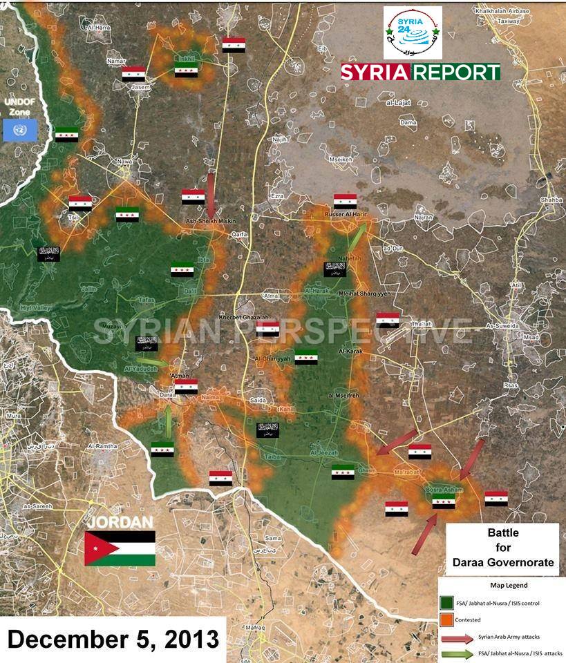
- Thanks. I wouldn't be surprised if the Dara frontlines had changed by now, but as a source Syrian Perspective seems to be quite contested on Wikipedia due to it being perceived as having a pro-government stance. MrPenguin20 ( talk) 17:48, 13 February 2014 (UTC)
That pro opposition [ map but on this map it is difficult to fully assess the situation. And pro opposition source said than the village Atman under the control of the army and the militants tried to attack village. source Hanibal911 ( talk) 18:40, 13 February 2014 (UTC)
Need to change the map of Dara this the pro opposition version of the map and you can based on it alter the map. with only one exception because the village Atman contested. source Hanibal911 ( talk) 21:13, 22 March 2014 (UTC)
- Updated!
MrPenguin20 (
talk) 21:59, 29 March 2014 (UTC)
- The Syrian army controls around 60 percent of the city of Daraa including
Daraa al-Mahatta, and the part of Daraa al-Balad known as
al-Manshiya rebels control only rest part of Daraa al-Balad, including the area known as al-Sadd and the adjacent Palestinian refugee camp.
Al Akhbar
Hanibal911 (
talk) 18:10, 4 April 2014 (UTC)
- Thanks. Changed now! :)
MrPenguin20 (
talk) 21:23, 8 April 2014 (UTC)
- Pro opposition source says that the Syrian army captured the city Naima to east of the city Dara.
source And once again thank you for your edit.
Hanibal911 (
talk) 07:03, 9 April 2014 (UTC)
- Thanks. I'm not entirely clear whether Labrousse was saying that the SAA had taken it, or whether he was saying they would break the siege if they took it. So for the moment I've changed the map to show the SAA advance on the town from the east/west/south (as per another of his tweets), and then if anywhere/anyone else mentions that the SAA has taken Naimah I'll change the town to government control. MrPenguin20 ( talk) 12:36, 9 April 2014 (UTC)
- Pro opposition source says that the Syrian army captured the city Naima to east of the city Dara.
source And once again thank you for your edit.
Hanibal911 (
talk) 07:03, 9 April 2014 (UTC)
- I think it is worth noting the presence of the army near the town of Naima. Because
source said that the clashes between regular forces and rebels on the outskirts of Naima on amid shelling of regular troops areas in the town.
Hanibal911 (
talk) 09:27, 11 April 2014 (UTC)
- KK. What I've done is I've marked the town as contested and extended the arrows showing the government movement.
MrPenguin20 (
talk) 20:37, 11 April 2014 (UTC)
- Thanks for the timely update.
Hanibal911 (
talk) 21:01, 11 April 2014 (UTC)
- No problem! Thanks for keeping me updated :). I was thinking of potentially making another map - any article you think particularly needs one?
MrPenguin20 (
talk) 21:04, 11 April 2014 (UTC)
- Maybe! Hanibal911 ( talk) 21:16, 11 April 2014 (UTC)
- No problem! Thanks for keeping me updated :). I was thinking of potentially making another map - any article you think particularly needs one?
MrPenguin20 (
talk) 21:04, 11 April 2014 (UTC)
- Thanks for the timely update.
Hanibal911 (
talk) 21:01, 11 April 2014 (UTC)
- KK. What I've done is I've marked the town as contested and extended the arrows showing the government movement.
MrPenguin20 (
talk) 20:37, 11 April 2014 (UTC)
- Thanks. Changed now! :)
MrPenguin20 (
talk) 21:23, 8 April 2014 (UTC)
- The Syrian army controls around 60 percent of the city of Daraa including
Daraa al-Mahatta, and the part of Daraa al-Balad known as
al-Manshiya rebels control only rest part of Daraa al-Balad, including the area known as al-Sadd and the adjacent Palestinian refugee camp.
Al Akhbar
Hanibal911 (
talk) 18:10, 4 April 2014 (UTC)
Syrian troops are fighting against the rebels in Gharz prison in Deraa province. SOHR Hanibal911 ( talk) 20:01, 6 May 2014 (UTC)
- I think that the battles are conducted in the southern area of Dara. SOHR said that regime forces opened heavy machine-gun fire on areas in Tariq al-Sad neighbourhood in the city Dar'a. SOHR Hanibal911 ( talk) 06:00, 19 August 2014 (UTC)
2013 Libyan coup d'état attempt
Dear Mr Penguin 20,
I've read your article about the 2013 Libyan coup d'état attempt. I am the editor of the Spanish language version and, as I can see, you have quite knowledge of the topic. Therefore, I would like to ask you a question:
As you know, Zeidan has said that a political party was behind the coup. Today he has added that he has evidences against 4 or 5 Congress Members. Since the Justice and Construction Party is the only one with that number of representatives (besides the liberals), can we take it as a confirmation of the role of the islamists?
Thanks for your time. I hope I haven't been of a bother -- 80.30.114.95 ( talk) 19:03, 14 October 2013 (UTC)
- Happy to help :). Certainly some people have been suggesting the Justice and Construction Party was involved, although there's also been some talk about Abdurrahman Sewehli and the Union for Homeland. As I understand if Zeidan claimed yesterday that those responsible don't belong to a particular party, and that he will publicly name those responsible in the next GNC session. As such J&C Party Members might have been involved, but their involvement might not be representative of the wider J&C Party. Since he's apparently going to name those responsible though, I'm personally just waiting until this announcement before updating the English page to show which political groups/figures were involved. MrPenguin20 ( talk) 19:55, 14 October 2013 (UTC)
- Could you please send me a reference to that hypothesis? I would be personally interested in reading about it. However, even if all the group Congressmen were involved, there would 2 more for another party. In that case, Zeidan would be talking about political forces (in the plural form), wouldn't he? Anyway, we just have to wait =D It has been a pleasure talking to you -- 80.30.114.95 ( talk) 13:46, 15 October 2013 (UTC)
Deir Ezzor
Rebels secure much of the city, syrian army retreats to Joura, mark qussor contested.
https://www.facebook.com/syriaohr/posts/433712646737079 Sopher99 ( talk) 20:39, 16 October 2013 (UTC)
- How does the new version look? MrPenguin20 ( talk) 15:44, 18 October 2013 (UTC)
You could update map. Here is a map showing situation at beginning of December. Hanibal911 ( talk) 09:48, 4 February 2014 (UTC)
- That's great! Updated now. MrPenguin20 ( talk) 21:30, 4 February 2014 (UTC)
Thank you. Hanibal911 ( talk) 21:39, 4 February 2014 (UTC)
The regime controls multiple areas within the city of Deir Ezzor, mainly the Joura and Al-Qousour neighborhoods and the Tala'eh area, in addition to military bases such as the military airport, the Tala'eh camp, Al-Jabal, and Brigade 137 on the outskirts of the city. Meanwhile, the most important neighborhoods in the city are controlled by opposition forces, including Rashdiyyah and Huwayqah. The opposition has also made tremendous progress in other besieged neighborhoods, including Al-Sinaaa, Al-Ummal, Al-Mouwazzafin, and Al-Jubaylah. But in these areas are still fighting and they should be marked as contested. Now News Hanibal911 ( talk) 20:13, 13 March 2014 (UTC)
You can correct the map because Huwayqah neighborhood not under the rebel control. Because pro opposition source said that the Huwayqah neighbourhood was also exposed to shelling by the FSA rebel earlier in a try to target the headquarters of the regime forces, resulting in a number of casualties. Ara News Hanibal911 ( talk) 08:51, 27 March 2014 (UTC)
- Hmm yeah. Most maps I've seen have Hiweqa under opposition control - I wonder where about the headquarters could be. It probably doesn't mean central Hawiqa, as if it were that then it'd mean that the Headquarters would be effectively surrounded. Then again, the Governor's house is in that area - could be that? Alternatively it might be in Western Hawiqa/Basatin al-Nahr area. MrPenguin20 ( talk) 22:13, 29 March 2014 (UTC)
Violent clashes broke out between regular forces and islamic fighters in the neighbourhoods of al-Jbeila and al-Sina’a. source Hanibal911 ( talk) 17:38, 26 April 2014 (UTC)
- Al Hweqa neighborhood should be marked as contested because the pro opposition source said that in this neighborhood clashes the army vs rebels. source Hanibal911 ( talk) 10:33, 28 May 2014 (UTC)
- Updated!
MrPenguin20 (
talk) 12:52, 18 June 2014 (UTC)
- You can update the map! Violent clashes between regime forces and Islamic battalions in al-Rashedya neighborhood.
source
Hanibal911 (
talk) 11:05, 27 June 2014 (UTC)
- Took a while, but updated now! MrPenguin20 ( talk) 00:13, 1 July 2014 (UTC)
- You can update the map! Violent clashes between regime forces and Islamic battalions in al-Rashedya neighborhood.
source
Hanibal911 (
talk) 11:05, 27 June 2014 (UTC)
APPU
Hi. Great work on the APPU article, really interesting piece of history. -- Soman ( talk) 14:38, 18 October 2013 (UTC)
- Thanks! Thanks for your help too :). Yeah I've been trying to expand the articles relating to Saudi left wing politics, it's just a shame there seems to generally be so few sources on it!
MrPenguin20 (
talk) 17:16, 18 October 2013 (UTC)
- Yes. Before Google Books, it was really hard to find anything online, at least in non-Arabic sources, about the Saudi left. There is a book, in Arabic, released sometime around 2008 or 2009, that gives more detail on the Gulf left. It would be great to include some material from there, I'll try to google it up. --
Soman (
talk) 17:42, 18 October 2013 (UTC)
- Yeah that sounds great! Let me know if you find it! MrPenguin20 ( talk) 17:43, 18 October 2013 (UTC)
- Yes. Before Google Books, it was really hard to find anything online, at least in non-Arabic sources, about the Saudi left. There is a book, in Arabic, released sometime around 2008 or 2009, that gives more detail on the Gulf left. It would be great to include some material from there, I'll try to google it up. --
Soman (
talk) 17:42, 18 October 2013 (UTC)
Aleppo offensive
Good work on the Aleppo offensive map! A few questions/corrections/suggestions:
- What are the bright red lines supposed to show?
- There's too much white space. While I could understand leaving areas that are in contested areas blank, your map extends to Saraqeb, which is undisputedly rebel.
- It should be made clearer that Kuwayris is government-held. That's not immediately obvious here.
- As far as I am aware, Safira city is totally under rebel control (for now), whereas your map shows it as divided.
- Abu Zuhur Airbase has been fully besieged for a long time with no serious efforts to relieve it. On your map it looks like it may be connected to other government ares. I also am sceptical as to whether the town of Abu Zuhur is government-held.
Regards, Lothar von Richthofen ( talk) 04:43, 19 October 2013 (UTC)
- Yeah what I mostly tend to do is upload a map showing a general outline of the strategic situation, and then work to fix all the problems, so thanks a lot for all the suggestions. I've edited the map to reflect pretty much all of them. The only thing that's not fully fixed yet is there's still some white in the bottom right hand corner of the map, as I was unsure of ownership in the greater Khanasser area. Would you say that government control is limited to the general area surrounding the road, or is it broader in the Khanasser area? Also the red lines were intended to show the government lines before the offensive, to make it clearer how much land has changed hands over the course of the offensive. How accurately it does this is another matter entirely... MrPenguin20 ( talk) 18:17, 19 October 2013 (UTC)
- Based on the fact that a lot of rebel videos showing the advance of government troops seem to be filmed in the cliffs and hills above the road, I wouldn't extend government control too far away from the it. At the same time, it is a frontline area and it stands to reason that the army would be conducting operations in those areas to keep rebels from cutting off the road again. What you have now for this seems fine, honestly, until better information arises.
- In that case, the red lines are wrong, near as I can tell. The stretch of road between Safira city and Khanasir was under rebel control prior to the offensive. It's been recaptured by the government now, but only after very bitter fighting.
- In late September, rebels launched an offensive of their own which led to the capture of the cluster of green dots in that area that are on the detailed map. Ahrar al-Sham released this map the day after the start of the offensive, which shows that the defence factories were connected to the main part of Aleppo city at that time. By six days after, they had captured territory up to here [1], severing one of the main roads but not totally cutting the factories off from the city. SANA reported that the army "recaptured" Turkan and Tall 'Abur, but honestly I don't think they had ever fallen out of their control; given SANA's generally abysmal credibility and the movements on the ground, I think that they just threw them in to inflate their "victory count".
- All this taken into account, the question remains as to whether the factories were connected to the research facility beforehand. Ahrar al-Sham's map and the aforementioned rebel control over the plains would seem to indicate that they weren't, so an enclave like this is possible, though I wouldn't rule out a narrow connection like this.
- Also, SOHR reported that a small detachment split off at Hakla to try and cross Lake Jabbul and relive Kuwayris. No further news from this, which means they were probably wiped off the map (really stupid move, IMO), but it should be indicated. ~~ Lothar von Richthofen ( talk) 19:16, 19 October 2013 (UTC)
- Thanks I'll get working on the changes! MrPenguin20 ( talk) 17:13, 22 October 2013 (UTC)
- Ok I've updated the map now. There's probably still some issues with the territory between the factories and Aleppo though. MrPenguin20 ( talk) 21:35, 24 October 2013 (UTC)
File:Rif Dimashq offensive (March 2013).svg
I have a request for you please. The map File:Rif Dimashq offensive (March 2013).svg is designated to cover the development of the offensive that lasted from March to August 2013. However, it was later updated with advances from the offensive that started in September and lasted until late November. I tried to reverting the map back to the last update that concerned the previous offensive, 23 September, however for some reason the map did not change. Could you please revert the map back to the last edit you made on 23 September? Thanks in advance! EkoGraf ( talk) 17:02, 7 December 2013 (UTC)
- I think it might have updated now to the version you reverted to. Sometimes there's a delay on the wikicommons server. It looks right now? MrPenguin20 ( talk) 20:52, 10 December 2013 (UTC)
ISIS map
Hello MrPenguin20,
as a main editor in the field of recent Syrian and Iraqi conflicts, and a creator of excellent maps at Commons, I would like to know your opinion about the File:Territorial control of the ISIS.svg. Several editors have questioned its accuracy (see File talk:Territorial control of the ISIS.svg) and it seems to contradict your map of Anbar ( File:Map of the Anbar clashes (2013–14).svg), which does not look as if ISIL would control wide parts of this province. I think that it might be helpful if you could step into this discussion. For now, I have outcommented the map from the articles that use it (but it is still used in other language versions of Wikipedia). -- RJFF ( talk) 18:15, 26 January 2014 (UTC)
.svg)
- Sure thing!
MrPenguin20 (
talk) 18:22, 26 January 2014 (UTC)
- Since the discussion about the deletion has been deleted, can you tell me how the map looks like now? As I keep saying in multiple discussions about it, I will just make the map shown with Syria, if need be. I also did not know that your map of Anbar existed, which would definitly have helped me with the Iraqi part of this map, as I have been using
Template:Syrian civil war detailed map for the Syria part. Just comment on your opinion here, I'll see it. Thanks! —
SPESH
531
Other 22:11, 26 January 2014 (UTC)
- I think in regards to Syria you're map looks pretty much spot on! The main issue was in regards to Anbar, but that's mostly because the nature of the ongoing conflict in Anbar means that the upper Euphrates area isn't so much an area of ISIL control as much as it is an area of ISIL strength, as the Iraqi Armed Forces as well as numerous other anti-government groups often operate in overlapping areas (especially in the countryside). The only areas where there's really a clear division of territory are in the cities (e.g. ISIL being focused on the stadium area in eastern Ramadi), but even there ISIL and the various other groups seem to have some kind of working relationship, so it's not quite clear exactly who controls what. So it's a terminology thing more than anything really, but that's only really because of the difference in the types of conflict. MrPenguin20 ( talk) 23:22, 26 January 2014 (UTC)
- Since the discussion about the deletion has been deleted, can you tell me how the map looks like now? As I keep saying in multiple discussions about it, I will just make the map shown with Syria, if need be. I also did not know that your map of Anbar existed, which would definitly have helped me with the Iraqi part of this map, as I have been using
Template:Syrian civil war detailed map for the Syria part. Just comment on your opinion here, I'll see it. Thanks! —
SPESH
531
Other 22:11, 26 January 2014 (UTC)
Rif Dimashq offensive Map
You made not all changing on map Rif Dimashq offensive because in city Douma clashes between Syrian army against FSA. The Daily Star Hanibal911 ( talk) 09:32, 2 February 2014 (UTC)
- Thanks! I'll change that now.
MrPenguin20 (
talk) 13:15, 2 February 2014 (UTC)
- Here is a
map showing situation in Darayya on end of January 2014.
Hanibal911 (
talk) 22:10, 4 February 2014 (UTC)
- The road which passes through Qadam under control of Syrian troops. The Independent And citys Babbila and Harasta must be changed to contested. Map Hanibal911 ( talk) 18:21, 6 February 2014 (UTC)
- Here is a
map showing situation in Darayya on end of January 2014.
Hanibal911 (
talk) 22:10, 4 February 2014 (UTC)
- You can change on map the suburb Harasta because many sources claim that Harasta mostly under control of the army. Yahoo News Al Jazeera MSN News Is Big Brother Watching You? Hanibal911 ( talk) 09:22, 10 February 2014 (UTC)
- Here is a maps this and this from a reliable source the Wall Street Journal. These maps shows that the army controls the entire area around the city of Al Tall. Hanibal911 ( talk) 11:23, 11 February 2014 (UTC)
- Palestinian Popular Front fighters replace Jabhat al-Nusra rebel group in a bid to alleviate suffering in Palestinian Yarmouk. Al Jazeera Hanibal911 ( talk) 13:00, 12 February 2014 (UTC)
- Yeah the map was changed a while ago to bring it in line with that map of Daraya. Having said that the map seemed to ignore the opposition presence in Moadameyah (although there's an ongoing truce). In regards to Hasrata, I've brought the frontlines closer to the city. It's now mostly in line with the WSJ maps, although the map shown here actually shows more area as being under opposition control. In regards to al-Tal, I don't think the current map suggests that the Army doesn't control that area as there's no real opposition presence shown, but I'll change it a little to make it clearer. With Yarmouk, it appears only al-Nusra has left so far. When the area becomes completely neutralized then I'll mark it as blue. The Independent article on Qadam was kind of ambiguous as to the real nature of what was going on, so I'll leave it as contested for now in line with the detailed map. The detailed map doesn't seem to say Babila and Beit Sahm are contested so much as they are surrounded/divided, so I think the current setup probably works best. (Contested suggests they're an ongoing area of conflict) MrPenguin20 ( talk) 17:34, 13 February 2014 (UTC)
Battles against the rebels were also reported in al-Mlaiha, Zibdin, Deir al-Asafir, Kafar Batna and Alia orchards near Damascus. Turkish Weekly Hanibal911 ( talk) 12:03, 25 February 2014 (UTC)
Homs
You can little adjust the map of city Homs. Here is the source of The Wall Street Journal has provided a more accurate map or that's the itself map from source if you cant be read source itself. It shows that the northern part of the district Al Waer now under the control of the army and some changes in the old town area. Hanibal911 ( talk) 21:34, 13 February 2014 (UTC)
- Thanks! I've updated it now. Yeah the map was previously also based on the WSJ map visible here from late January. I have to wonder whether changes are coming about out of changes on the ground, or are arising out of the fixing of previous maps. You know if the frontlines in Homs have been particularly active of late? MrPenguin20 ( talk) 01:32, 14 February 2014 (UTC)
- I think that is only adjustment on the map due to clarifying the situation directly in the Homs. So far as I know at the moment in the disputed areas acts truce. Perhaps in this situation, some journalists of easier clarify the situation.
Hanibal911 (
talk) 08:59, 14 February 2014 (UTC)
- You can make changes to this map Siege of Homs Map because in the village Dar al-Kabirah clashes Syrian army against the rebels. The Daily Star Hanibal911 ( talk) 07:33, 7 April 2014 (UTC)
- I think that is only adjustment on the map due to clarifying the situation directly in the Homs. So far as I know at the moment in the disputed areas acts truce. Perhaps in this situation, some journalists of easier clarify the situation.
Hanibal911 (
talk) 08:59, 14 February 2014 (UTC)
If you have questions on data that I sent you I am ready to answer them. Since some maps need to be updated. And thank you for your work. Hanibal911 ( talk) 13:42, 8 April 2014 (UTC)
- Hey sorry just been a bit busy with work/been working from my laptop (which I hate using Inkscape on :/ - it's fine for basically just changing colours but I tend to need a mouse for editing the Syria maps). I'll take a look and fix those things now! :)
MrPenguin20 (
talk) 21:08, 8 April 2014 (UTC)
- Syrian army troops backed by pro-regime militiamen entered rebel-held neighborhoods of the central city of Homs. The Syrian army and the National Defence Forces have achieved key successes in the Old City of Homs. They have entered into one (besieged) area, Wadi al-Sayeh, which lies between Juret al-Shiyah and the Old City.
The Daily Star
Yahoo News
Al Arabia
Hanibal911 (
talk) 15:54, 15 April 2014 (UTC)
- Area of the Old City which is now marked under rebel control need be noted as contested because army start offensive in rebel-held areas. Syrian army troops entered rebel-held neighbourhoods of the central city of Homs after laying siege to the districts for nearly two years. Government troops entered areas of the Old City in Homs that had been under rebel control throughout the siege. Army entered into one area, Wadi al-Sayeh, which lies between Juret al-Shiyah and the Old City.
The Independent
Hanibal911 (
talk) 09:53, 17 April 2014 (UTC)
- Thanks! I'll update this tomorrow!
MrPenguin20 (
talk) 20:32, 17 April 2014 (UTC)
- The Syrian army advanced in the central city of Homs and seized several buildings in Wadi Al-Sayeh, including St. George church, in the old quarter of the city called Old Homs.
The Daily Star
Hanibal911 (
talk) 17:28, 18 April 2014 (UTC)
- Syria army says controls sections of Hamidiyah and St. Michael church in besieged old quarter of Homs. Here is the data from the reporter of Wall Street Gournal
source
Hanibal911 (
talk) 19:04, 18 April 2014 (UTC)
- I know where St Georges/Wadi al-Sayed is but any idea where St Michael's is? The Old City can often be applied quite broadly. I'm thinking the main thrust of the offensive might be from the North-East/East.
MrPenguin20 (
talk) 01:19, 19 April 2014 (UTC)
- Probably! Hanibal911 ( talk) 05:20, 19 April 2014 (UTC)
- I know where St Georges/Wadi al-Sayed is but any idea where St Michael's is? The Old City can often be applied quite broadly. I'm thinking the main thrust of the offensive might be from the North-East/East.
MrPenguin20 (
talk) 01:19, 19 April 2014 (UTC)
- Syria army says controls sections of Hamidiyah and St. Michael church in besieged old quarter of Homs. Here is the data from the reporter of Wall Street Gournal
source
Hanibal911 (
talk) 19:04, 18 April 2014 (UTC)
- The Syrian army advanced in the central city of Homs and seized several buildings in Wadi Al-Sayeh, including St. George church, in the old quarter of the city called Old Homs.
The Daily Star
Hanibal911 (
talk) 17:28, 18 April 2014 (UTC)
- Thanks! I'll update this tomorrow!
MrPenguin20 (
talk) 20:32, 17 April 2014 (UTC)
- Area of the Old City which is now marked under rebel control need be noted as contested because army start offensive in rebel-held areas. Syrian army troops entered rebel-held neighbourhoods of the central city of Homs after laying siege to the districts for nearly two years. Government troops entered areas of the Old City in Homs that had been under rebel control throughout the siege. Army entered into one area, Wadi al-Sayeh, which lies between Juret al-Shiyah and the Old City.
The Independent
Hanibal911 (
talk) 09:53, 17 April 2014 (UTC)
- Syrian army forces seized a church in the Old City and also had seized buildings in the Bab Hud and Wadi al-Sayeh districts.
The Daily Star
Hanibal911 (
talk) 14:45, 19 April 2014 (UTC)
- now the city of Homs is under the control of the government after the Syrian army and the rebels signed a truce with the rebels, under the terms of the armistice all rebels evacuated outside the city of Homs on the territory north of the city that are still under rebel control.
Canada.com
SOHR
The Washington Post
Al Arabia
Arab Chronicle
Reuters
Al Jazeera
Hanibal911 (
talk) 15:37, 2 May 2014 (UTC)
- You can fix the map because the rebels withdraw from the Homs in rebel-held towns of Talbisah and Dar al-Kabira.
BBC
Al Jazeera
Hanibal911 (
talk) 16:52, 7 May 2014 (UTC)
- Under the terms of the agreement between the Syrian government and rebels the government forces take over all rebels districts in Homs city and Al Waer district in western Homs city.
Al Jazeera
Hanibal911 (
talk) 19:47, 7 May 2014 (UTC)
- Thanks! So that means the only area the opposition controls is to the north of Homs? What I ought to do now then is change the map to show the various areas controlled during the siege of Homs. (Seeing as the siege then would seem to be effectively over) MrPenguin20 ( talk) 17:08, 8 May 2014 (UTC)
- Under the terms of the agreement between the Syrian government and rebels the government forces take over all rebels districts in Homs city and Al Waer district in western Homs city.
Al Jazeera
Hanibal911 (
talk) 19:47, 7 May 2014 (UTC)
- You can fix the map because the rebels withdraw from the Homs in rebel-held towns of Talbisah and Dar al-Kabira.
BBC
Al Jazeera
Hanibal911 (
talk) 16:52, 7 May 2014 (UTC)
- now the city of Homs is under the control of the government after the Syrian army and the rebels signed a truce with the rebels, under the terms of the armistice all rebels evacuated outside the city of Homs on the territory north of the city that are still under rebel control.
Canada.com
SOHR
The Washington Post
Al Arabia
Arab Chronicle
Reuters
Al Jazeera
Hanibal911 (
talk) 15:37, 2 May 2014 (UTC)
- Syrian army troops backed by pro-regime militiamen entered rebel-held neighborhoods of the central city of Homs. The Syrian army and the National Defence Forces have achieved key successes in the Old City of Homs. They have entered into one (besieged) area, Wadi al-Sayeh, which lies between Juret al-Shiyah and the Old City.
The Daily Star
Yahoo News
Al Arabia
Hanibal911 (
talk) 15:54, 15 April 2014 (UTC)
- It will be right because the rebels left the city of Homs.
The Daily Star
Hanibal911 (
talk) 18:28, 8 May 2014 (UTC)
- Even the pro opposition source of recognizes that the of Homs under army control.
Arab Chronicle and also this source confirm that the under the terms of the contract between the government and rebels army gains full control over Al Waer.
Al Jazeera
Hanibal911 (
talk) 18:43, 8 May 2014 (UTC)
- Oh I'm sure it's right (I'll update it tomorrow). I was just saying that what I should do is change the map so that the various areas controlled by the opposition during the siege of Homs should be shown, to give an idea of the evolution of the siege.
MrPenguin20 (
talk) 20:40, 8 May 2014 (UTC)
- You can update the map to we can use her for this article
Siege of Homs.
Hanibal911 (
talk) 20:44, 10 May 2014 (UTC)
- I've changed it now to show the current layout (with the government controlling all of central Homs). I'll have a version uploaded showing the evolution of the siege tonight! MrPenguin20 ( talk) 17:34, 12 May 2014 (UTC)
- You can update the map to we can use her for this article
Siege of Homs.
Hanibal911 (
talk) 20:44, 10 May 2014 (UTC)
- Oh I'm sure it's right (I'll update it tomorrow). I was just saying that what I should do is change the map so that the various areas controlled by the opposition during the siege of Homs should be shown, to give an idea of the evolution of the siege.
MrPenguin20 (
talk) 20:40, 8 May 2014 (UTC)
- Even the pro opposition source of recognizes that the of Homs under army control.
Arab Chronicle and also this source confirm that the under the terms of the contract between the government and rebels army gains full control over Al Waer.
Al Jazeera
Hanibal911 (
talk) 18:43, 8 May 2014 (UTC)
Battle of Qalamoun map
Your card is not accurate because the city of Al Sahel Reuters Yahoo News Al Jazeera and Rima Yahoo News Global Tims First Post under the control of the army. Hanibal911 ( talk) 07:28, 10 March 2014 (UTC)
- Thanks! Updated now.
MrPenguin20 (
talk) 13:02, 10 March 2014 (UTC)
- Your map is great but one correction. At the start of the offensive Deir Attiyeh was already under government control. It was during the offensive that the rebels temporarily captured most of the city (not even the whole town) and 6 days later the Army recaptured it. So the town maybe shouldn't be outside the starting line? But the map maybe works fine also the way it is. Your call.
EkoGraf (
talk) 15:25, 10 March 2014 (UTC)
- Thanks! No you're right - I've changed it now to show Deir Attiyeh under Government control at the beginning of the offensive. Then what I'll do is I'll add another line showing the furthest advance of the opposition counterattack.
MrPenguin20 (
talk) 16:43, 10 March 2014 (UTC)
- Syrian forces entered the key rebel bastion of Yabrud from the east, and advanced along the town's main street. The Daily Star Al Akhbar Reuters Al Jazeera Hanibal911 ( talk) 10:53, 15 March 2014 (UTC)
- Thanks! No you're right - I've changed it now to show Deir Attiyeh under Government control at the beginning of the offensive. Then what I'll do is I'll add another line showing the furthest advance of the opposition counterattack.
MrPenguin20 (
talk) 16:43, 10 March 2014 (UTC)
- Your map is great but one correction. At the start of the offensive Deir Attiyeh was already under government control. It was during the offensive that the rebels temporarily captured most of the city (not even the whole town) and 6 days later the Army recaptured it. So the town maybe shouldn't be outside the starting line? But the map maybe works fine also the way it is. Your call.
EkoGraf (
talk) 15:25, 10 March 2014 (UTC)
- Thanks! I've updated the maps for Qalamonu & Deir Ezzor now :). MrPenguin20 ( talk) 20:06, 15 March 2014 (UTC)
- Syria army in full control of Yabroud, Syrian state media and opposition activists have reported.
Al Jazeera
Al Arabia
Hanibal911 (
talk) 09:49, 16 March 2014 (UTC)
- Army troops were advancing towards Ras al-Ain, southwest of Yabrud, and captured several hills overlooking the village. Later, it was reported the military entered Ras al-Ain and was progressing.
The Daily Star
Ahram Online
Agency France Press
- Meanwhile, northwest of Yabrud, the Army entered Ras al-Maarra and captured large parts of it.
SOHR
Hanibal911 (
talk) 21:38, 18 March 2014 (UTC)
- Thanks I've updated that now. I also changed Manin to opposition control, in line with the
detailed map. I noticed that the map says that Wadi Barada (which is now marked on the map) is also under opposition control. Do you happen to know if it's an isolated pocket, or whether it's connected to the main opposition controlled area?
MrPenguin20 (
talk) 00:49, 19 March 2014 (UTC)
- In late October 2013 the village was under rebel control but completely surrounded by the army and the whole surrounding area under the control of the army.
Times of Israel
24News
Global Post so I think we can be noted under the control of the rebels but completely surrounded the Syrian army.
- And also you can change the village of Ras al Ain because this village contested. Yahoo NEWS And also in cities Bloudan and Talfita now there are fights. detailed map Hanibal911 ( talk) 06:24, 19 March 2014 (UTC)
- In late October 2013 the village was under rebel control but completely surrounded by the army and the whole surrounding area under the control of the army.
Times of Israel
24News
Global Post so I think we can be noted under the control of the rebels but completely surrounded the Syrian army.
- Thanks I've updated that now. I also changed Manin to opposition control, in line with the
detailed map. I noticed that the map says that Wadi Barada (which is now marked on the map) is also under opposition control. Do you happen to know if it's an isolated pocket, or whether it's connected to the main opposition controlled area?
MrPenguin20 (
talk) 00:49, 19 March 2014 (UTC)
- Meanwhile, northwest of Yabrud, the Army entered Ras al-Maarra and captured large parts of it.
SOHR
Hanibal911 (
talk) 21:38, 18 March 2014 (UTC)
- Army troops were advancing towards Ras al-Ain, southwest of Yabrud, and captured several hills overlooking the village. Later, it was reported the military entered Ras al-Ain and was progressing.
The Daily Star
Ahram Online
Agency France Press
- Syria army in full control of Yabroud, Syrian state media and opposition activists have reported.
Al Jazeera
Al Arabia
Hanibal911 (
talk) 09:49, 16 March 2014 (UTC)
The SOHR, a Britain-based NGO, reported fierce fighting between regime and rebel forces at a checkpoint near the town of Rankus, south of Yabrud and SOHR also said regime troops backed by Lebanon's Hezbollah and pro-regime militia were also fighting rebel and jihadist forces around the villages of Bkhaa and Jobeh in Qalamoun region. The Daily Star Naharnet Hanibal911 ( talk) 10:25, 19 March 2014 (UTC)
Army units took over Ras Al Ain, southwest of Yabroud, state news agency SANA said. The SOHR also confirmed the takeover, and said the army was backed by Lebanon’s Shiite Hezbollah and the paramilitary National Defence Forces. Gulf News NOW News Hanibal911 ( talk) 14:41, 19 March 2014 (UTC)
- Thanks I've updated most of that now. I've not marked down the fighting in Bkhaa and Jobeh yet though, as I was unsure exactly where the fighting was coming from. E.g. Bkhaa is somewhat central in the Qalamoun area, so I was unsure whether the fighting was arising from a govt push from the eastern highway or the Lebanese border (or both?). MrPenguin20 ( talk) 23:01, 19 March 2014 (UTC)
The village Manin is under control of the army correct this inaccuracy. detailed map Hanibal911 ( talk) 07:29, 20 March 2014 (UTC)
I think you should show on map advances the Syrian army sideways the villages Bakh'a and Jobeh from the east from the side of the existing front line because the source said that the fighting taking place around these villages. Naharnet With the tactical side it is the most logical decision. Also worth noting on map the village Falita in surrounded. detailed map Hanibal911 ( talk) 07:52, 20 March 2014 (UTC)
- The Syrian army took control the villages of Ras al-Maarra and Flita. The Daily Star Agence France Press Hanibal911 ( talk) 11:07, 29 March 2014 (UTC)
- Yeah I was a bit unsure about the best way to maybe show the advance, but given that I've not seen much talk of either Bakha or Jibba being surrounded I figured the advance was probably from the North. I've updated it a bit now to bring it up to speed.
MrPenguin20 (
talk) 21:47, 29 March 2014 (UTC)
- Military captured the Saidnaya Observatory near Rankus
source
source also government forces captured a hilltop overlooking Rankus as well as a few neighborhoods of the town.
The Daily Star
Hanibal911 (
talk) 07:09, 9 April 2014 (UTC)
- Added that now. I think the hill that the Daily Star article mentions is probably the same hill with the Observatory on it. Since it didn't say which neighborhoods were taken I've left the town itself marked as contested, although naturally I'll change it as the situation becomes clearer. MrPenguin20 ( talk) 12:32, 9 April 2014 (UTC)
- Military captured the Saidnaya Observatory near Rankus
source
source also government forces captured a hilltop overlooking Rankus as well as a few neighborhoods of the town.
The Daily Star
Hanibal911 (
talk) 07:09, 9 April 2014 (UTC)
- Yeah I was a bit unsure about the best way to maybe show the advance, but given that I've not seen much talk of either Bakha or Jibba being surrounded I figured the advance was probably from the North. I've updated it a bit now to bring it up to speed.
MrPenguin20 (
talk) 21:47, 29 March 2014 (UTC)
Syrian troops backed by Hezbollah fighters seize control of the rebel-held town of Rankous near the Lebanese border. Al Jazeera The Arab Chronicle The Arab Chronicle NOW News The Daily Star Al Arabia Gulf News Hanibal911 ( talk) 15:11, 9 April 2014 (UTC)
- Updated!
MrPenguin20 (
talk) 17:46, 9 April 2014 (UTC)
- North of the capital, the army overran a string of hills overlooking Rankus, a former opposition stronghold in the strategic Qalamun mountain.
The Daily Star
Hanibal911 (
talk) 19:52, 13 April 2014 (UTC)
- Syrian forces take 3 villages Al-Sarkha (Bakhah), Maaloula and Jibbeh near Lebanese border. Also A pro-rebel activist in Qalamoun who uses the name Amer confirmed the military had taken the communities, but said Jibbeh and Jbaadin had never been in opposition hands. SOHR confirmed that both communities had never been under rebel control.
The Daily Star
Hanibal911 (
talk) 17:12, 14 April 2014 (UTC)
- Updated! That's interesting about Jibbeh. I suppose it was still fair to previously mark it as being in opposition held territory, even if there wasn't a direct opposition presence in the town itself.
MrPenguin20 (
talk) 17:44, 14 April 2014 (UTC)
- Also I think that worth noting is the village Bloudan under army control in accordance with this
map. It also confirms the pro opposition
source
Hanibal911 (
talk) 18:18, 14 April 2014 (UTC)
- Changed that now. Also I added an opposition presence north of Dumayr, as can be seen on
these
two pro-government sources. I've marked it a bit differently seeing as it's unclear how strong their control is (I'm assuming it's more a general presence rather than strict frontlines).
MrPenguin20 (
talk) 18:43, 14 April 2014 (UTC)
- But a new map from the pro government source does not mention about the rebels in this area. source Hanibal911 ( talk) 19:05, 14 April 2014 (UTC)
- Changed that now. Also I added an opposition presence north of Dumayr, as can be seen on
these
two pro-government sources. I've marked it a bit differently seeing as it's unclear how strong their control is (I'm assuming it's more a general presence rather than strict frontlines).
MrPenguin20 (
talk) 18:43, 14 April 2014 (UTC)
- Also I think that worth noting is the village Bloudan under army control in accordance with this
map. It also confirms the pro opposition
source
Hanibal911 (
talk) 18:18, 14 April 2014 (UTC)
- Updated! That's interesting about Jibbeh. I suppose it was still fair to previously mark it as being in opposition held territory, even if there wasn't a direct opposition presence in the town itself.
MrPenguin20 (
talk) 17:44, 14 April 2014 (UTC)
- Syrian forces take 3 villages Al-Sarkha (Bakhah), Maaloula and Jibbeh near Lebanese border. Also A pro-rebel activist in Qalamoun who uses the name Amer confirmed the military had taken the communities, but said Jibbeh and Jbaadin had never been in opposition hands. SOHR confirmed that both communities had never been under rebel control.
The Daily Star
Hanibal911 (
talk) 17:12, 14 April 2014 (UTC)
- The army, backed by Hezbollah fighters, retook Aasal al-Ward.
The Daily Star
Albawaba
Hanibal911 (
talk) 15:40, 15 April 2014 (UTC)
- I think that after the capture of the Syrian army village Assal Al-Ward territory to the west of the village to the Lebanese border should be noted under the control of the army as shown in this pro government
source
Hanibal911 (
talk) 18:10, 15 April 2014 (UTC)-
- Syrian troops captured the city Hawsh Arab but rebels still control the city Talfita which is surrounded by army
Miami Herald
Kansascity News
Washington Examiner
Hanibal911 (
talk) 12:23, 16 April 2014 (UTC)
- Thanks! I'll update it later today!
MrPenguin20 (
talk) 15:31, 16 April 2014 (UTC)
- Here is the map from the pro government source which displays situation in the Qalamoun. So I think it is worth noting the areas north of the city Dumayr under the control of the army because this pro government source more correct and detailed indicate situation than the previous one. these Hanibal911 ( talk) 17:23, 16 April 2014 (UTC)
- Yeah I'll remove the Dumayr area presence. There is something there though - e.g. the detailed map shows a presence in the area, and the Yalla Souriya site mentions fighting to the south east. But I'll remove it until the actual border/presence there is clearer. I'm not sure if that map's right - e.g according to the detailed map there's still a presence in al-Ma'murah etc. We'll see if anywhere else posts news of such gains - because if true then they're pretty substantial (and I'd imagine would get some major coverage).
MrPenguin20 (
talk) 21:54, 16 April 2014 (UTC)
- The city Halboun under control the Syrian troops this confirms pro opposition
source
Hanibal911 (
talk) 18:48, 21 April 2014 (UTC)
- The village Al Mamurah is under the control of Army and rebels retreated to the town of Zabadani but even there, many of the rebels surrender.
map
The Australian
Hanibal911 (
talk) 17:36, 25 April 2014 (UTC)
- Opposition fighters in the Syrian town of Zabadani have surrendered after intense fighting with regime troops, losing their last stronghold along Lebanon's border. Also, the city Bloudan is no longer surrounded by rebels and the army controls nearly the entire area Qalamoun.
Al Jazeera
Hanibal911 (
talk) 18:57, 26 April 2014 (UTC)
- Updated! Others should be updated soon too. MrPenguin20 ( talk) 09:59, 2 May 2014 (UTC)
- Opposition fighters in the Syrian town of Zabadani have surrendered after intense fighting with regime troops, losing their last stronghold along Lebanon's border. Also, the city Bloudan is no longer surrounded by rebels and the army controls nearly the entire area Qalamoun.
Al Jazeera
Hanibal911 (
talk) 18:57, 26 April 2014 (UTC)
- The village Al Mamurah is under the control of Army and rebels retreated to the town of Zabadani but even there, many of the rebels surrender.
map
The Australian
Hanibal911 (
talk) 17:36, 25 April 2014 (UTC)
- The city Halboun under control the Syrian troops this confirms pro opposition
source
Hanibal911 (
talk) 18:48, 21 April 2014 (UTC)
- Thanks! I'll update it later today!
MrPenguin20 (
talk) 15:31, 16 April 2014 (UTC)
- Syrian troops captured the city Hawsh Arab but rebels still control the city Talfita which is surrounded by army
Miami Herald
Kansascity News
Washington Examiner
Hanibal911 (
talk) 12:23, 16 April 2014 (UTC)
- I think that after the capture of the Syrian army village Assal Al-Ward territory to the west of the village to the Lebanese border should be noted under the control of the army as shown in this pro government
source
Hanibal911 (
talk) 18:10, 15 April 2014 (UTC)-
- Need to update the map because the citys Halboun and Al Mamurah under army control.
map source
source And in accordance with the data from this
source the whole area under the control of the army with the exception of the city of Zabadani in which still remain pockets of resistance of the rebels.
Hanibal911 (
talk) 18:22, 8 May 2014 (UTC)
- Eep my bad - thought I'd already uploaded the fixed version. It's updated now! MrPenguin20 ( talk) 15:32, 10 May 2014 (UTC)
- North of the capital, the army overran a string of hills overlooking Rankus, a former opposition stronghold in the strategic Qalamun mountain.
The Daily Star
Hanibal911 (
talk) 19:52, 13 April 2014 (UTC)
March 2014
![]() Hello, I'm
BracketBot. I have automatically detected that
your edit to
Edinburgh (Parliament of Scotland constituency) may have broken the
syntax by modifying 2 "{}"s. If you have, don't worry: just
edit the page again to fix it. If I misunderstood what happened, or if you have any questions, you can leave a message on
my operator's talk page.
Hello, I'm
BracketBot. I have automatically detected that
your edit to
Edinburgh (Parliament of Scotland constituency) may have broken the
syntax by modifying 2 "{}"s. If you have, don't worry: just
edit the page again to fix it. If I misunderstood what happened, or if you have any questions, you can leave a message on
my operator's talk page.
- List of unpaired brackets remaining on the page:
- | style="background-color:#DDEEFF}}" |
- |}
It's OK to remove this message. Also, to stop receiving these messages, follow these opt-out instructions. Thanks, BracketBot ( talk) 01:27, 30 March 2014 (UTC)
Orphaned non-free media (File:Liwaa Al-Umma logo.png)
![]() Thanks for uploading
File:Liwaa Al-Umma logo.png. The media description page currently specifies that it is non-free and may only be used on Wikipedia under a
claim of fair use. However, it is currently
orphaned, meaning that it is not used in any articles on Wikipedia. If the media was previously in an article, please go to the article and see why it was removed.
You may add it back if you think that will be useful. However, please note that media for which a replacement could be created are not acceptable for use on Wikipedia (see
our policy for non-free media).
Thanks for uploading
File:Liwaa Al-Umma logo.png. The media description page currently specifies that it is non-free and may only be used on Wikipedia under a
claim of fair use. However, it is currently
orphaned, meaning that it is not used in any articles on Wikipedia. If the media was previously in an article, please go to the article and see why it was removed.
You may add it back if you think that will be useful. However, please note that media for which a replacement could be created are not acceptable for use on Wikipedia (see
our policy for non-free media).
If you have uploaded other unlicensed media, please check whether they're used in any articles or not. You can find a list of 'file' pages you have edited by clicking on the " my contributions" link (it is located at the very top of any Wikipedia page when you are logged in), and then selecting "File" from the dropdown box. Note that all non-free media not used in any articles will be deleted after seven days, as described on criteria for speedy deletion. Thank you. Werieth ( talk) 17:03, 31 March 2014 (UTC)
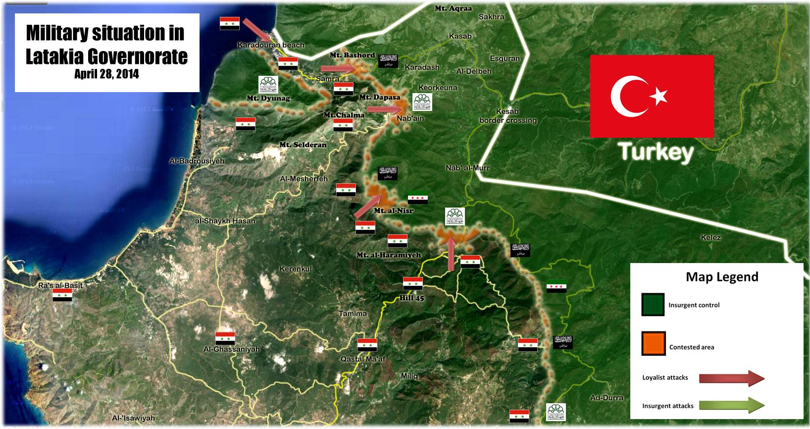
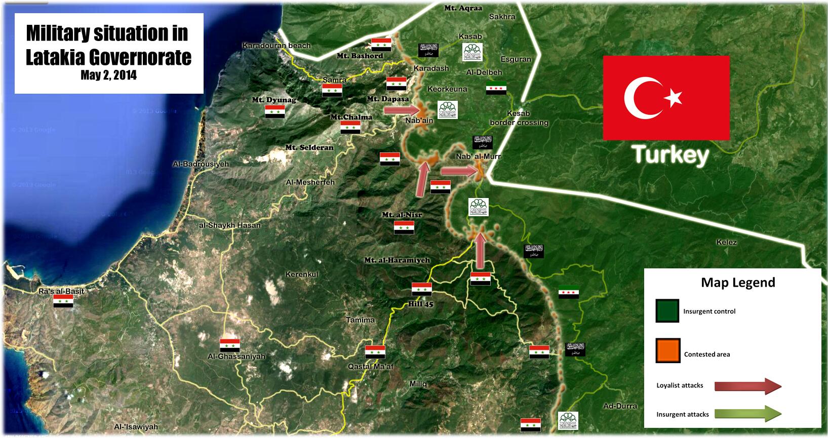
2014 Latakia Offensive
You can update this map Because the Syrian troops launched a counteroffensive. Here is the map from the pro opposition source which displays the Syrian army offensive. Hanibal911 ( talk) 16:53, 15 April 2014 (UTC)
- Thanks! Updated.
MrPenguin20 (
talk) 22:47, 16 April 2014 (UTC)
- Thanks!
Hanibal911 (
talk) 05:21, 17 April 2014 (UTC)
- Clashes in the center of the village of Samra and the Syrian troops backed allies take control over parts of the village.
source
Hanibal911 (
talk) 17:37, 27 April 2014 (UTC)
- Pro opposition source and pro government source reported that the village Samra under army control. Hanibal911 ( talk) 20:14, 27 April 2014 (UTC)
- Here's another confirmation from a reliable source.
The Daily Star
Hanibal911 (
talk) 15:51, 28 April 2014 (UTC)
- Here is how the
map looks after the capture of the village of Samra on the map can be seen that the Syrian army launched an attack on the village from the beach Karadouran it confirms and
opposition sources.
Hanibal911 (
talk) 15:48, 28 April 2014 (UTC)
- city of Nab'ain now contested it confirms pro opposition source of SOHR. source Hanibal911 ( talk) 12:29, 2 May 2014 (UTC)
- Here is how the
map looks after the capture of the village of Samra on the map can be seen that the Syrian army launched an attack on the village from the beach Karadouran it confirms and
opposition sources.
Hanibal911 (
talk) 15:48, 28 April 2014 (UTC)
- Clashes in the center of the village of Samra and the Syrian troops backed allies take control over parts of the village.
source
Hanibal911 (
talk) 17:37, 27 April 2014 (UTC)
- Thanks!
Hanibal911 (
talk) 05:21, 17 April 2014 (UTC)
- You can update the map fighting in Latakia province according to new data.
Hanibal911 (
talk) 18:10, 8 May 2014 (UTC)
- Here's how looks like the situation in the Latakia province in area the town Kesab.
Pro government source But some data from other sources partially confirm the data are listed in the pro government source. These data I listed earlier.
Hanibal911 (
talk) 20:32, 9 May 2014 (UTC)
- Thanks. Updated that now too.
MrPenguin20 (
talk) 15:48, 10 May 2014 (UTC)
- Syrian Army took control of Kasab, its border crossing, Al-Nab'in and Nab Al-Murr, fully reversing all opposition gains during the three-month campaign.
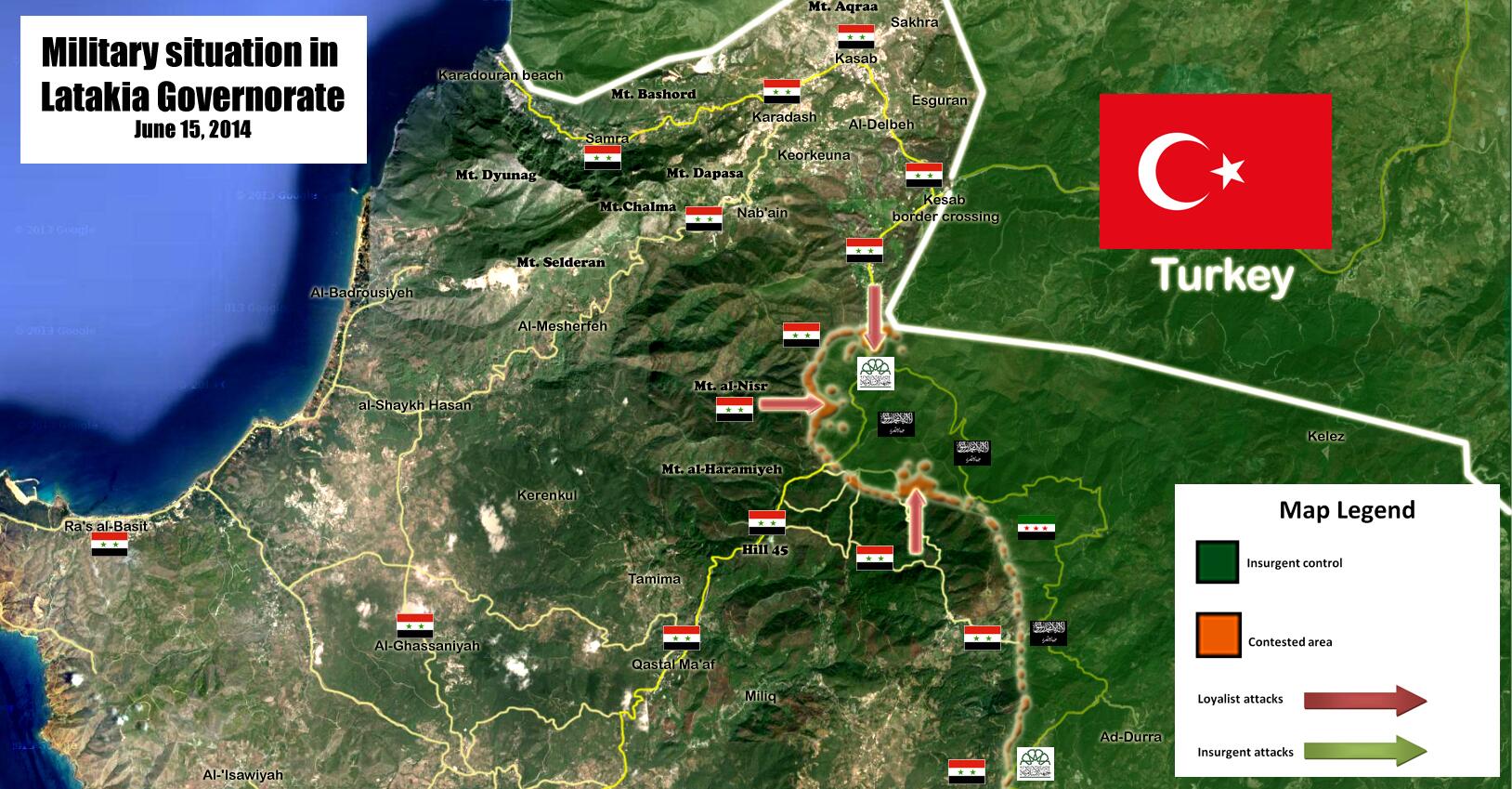
Syrian government retakes border town in Assad coastal heartland
"System controls the gain and Mabrha and bitter spring". Syriahr.com.
"Syrian Army Crushes Rebel Push Near Turkish Border". Time. Associated Press. Here is how the
map looks on 15 June so you can update map. Meanwhile, the Army intensified its operations in the east of the province near Salma.
[5]
Hanibal911 (
talk) 05:22, 17 June 2014 (UTC)
- You can update the map of Latakia province. I gave you all data to update.
Hanibal911 (
talk) 17:05, 18 June 2014 (UTC)
- Updated!
MrPenguin20 (
talk) 23:20, 18 June 2014 (UTC)
- Thanks buddy!
Hanibal911 (
talk) 05:36, 19 June 2014 (UTC)
- No problem :). Thanks for keeping me up to date! MrPenguin20 ( talk) 10:50, 19 June 2014 (UTC)
- Thanks buddy!
Hanibal911 (
talk) 05:36, 19 June 2014 (UTC)
- Updated!
MrPenguin20 (
talk) 23:20, 18 June 2014 (UTC)
- You can update the map of Latakia province. I gave you all data to update.
Hanibal911 (
talk) 17:05, 18 June 2014 (UTC)
- Syrian Army took control of Kasab, its border crossing, Al-Nab'in and Nab Al-Murr, fully reversing all opposition gains during the three-month campaign.
Syrian government retakes border town in Assad coastal heartland
"System controls the gain and Mabrha and bitter spring". Syriahr.com.
"Syrian Army Crushes Rebel Push Near Turkish Border". Time. Associated Press. Here is how the
map looks on 15 June so you can update map. Meanwhile, the Army intensified its operations in the east of the province near Salma.
[5]
Hanibal911 (
talk) 05:22, 17 June 2014 (UTC)
- Thanks. Updated that now too.
MrPenguin20 (
talk) 15:48, 10 May 2014 (UTC)
- Here's how looks like the situation in the Latakia province in area the town Kesab.
Pro government source But some data from other sources partially confirm the data are listed in the pro government source. These data I listed earlier.
Hanibal911 (
talk) 20:32, 9 May 2014 (UTC)
Donbass People's Militia flag
Hello again MrPenguin20. I've noticed that you uploaded flags of the Donetsk People's Republic, and Lugansk Parliamentary Republic. I was wondering if you would be able to make the Donbass People's Militia flag. The spelling is НАРОДНОЕ ОПОЛЧЕНИЕ ДОНБАССА, and this is how it looks, http://cyplive.com/eng/news/opolchenie-donbassa-zaderzhalo-dva-avtobusa-s-lyudmi-dlya-razgona-mitinga.html http://rt.com/news/ukraine-troops-withdraw-slavyansk-940/ SkoraPobeda ( talk) 19:26, 16 April 2014 (UTC)
- Done! It's available
here. There's still a couple of issues, but I'll fix those!
MrPenguin20 (
talk) 22:35, 16 April 2014 (UTC)
- Thanks! You are a pro at these :)
SkoraPobeda (
talk) 23:05, 16 April 2014 (UTC)
- Aw shucks :P MrPenguin20 ( talk) 23:19, 16 April 2014 (UTC)
- Thanks! You are a pro at these :)
SkoraPobeda (
talk) 23:05, 16 April 2014 (UTC)
Qalamoun map
Hi, can you remove the "Hezbollah presence" from the majority-Sunni areas of Tufayl and 'Arsal in Lebanon on the Qalamoun map? The former isn't even reliably accessible from Lebanon, and has been under de facto Syrian rebel control for much of the conflict (see this); the latter is a well-known anti-Hezbollah stronghold with only a minimal Lebanese Army presence on the town's outskirts (they don't dare go further out into the mountains; source) that Hezbollah has only been able blockade from the west In fact, I don't know of any sources that confirm that Hezbollah has any real presence along the border, and AFAIK there were no cross-border attacks by them during this most recent offensive (unlike in Qusayr, where they did control the border). ~~ Lothar von Richthofen ( talk) 18:12, 22 April 2014 (UTC)
But as the Syrian army scored a string of victories this year in the surrounding Qalamoun area, Tufail's residents found themselves trapped. For weeks the town's population has been unable to leave or receive any kind of assistance, with Syrian armed forces blocking the routes into Syria. Lebanon's Interior Minister Nouhad Machnouk also said he had been in touch with Hezbollah in a bid to secure safe passage for the aid convoy through the village of Britel, which neighbors Tufeil in Lebanon. An AFP journalist, who traveled with the convoy until Ras al-Harf, six kilometers (four miles) from Tufail, said the terrain was rugged and that Hezbollah positions and flags were clearly visible. Al Akhbar Hanibal911 ( talk) 18:33, 22 April 2014 (UTC)
- If they are currently present there, it is the result of an advance (probably through Syria). The current map presents the situation as though HA was always present there from the beginning of the offensive—which is definitively not the case. As the article I provided confirms, the area was rebel-controlled as recently as the beginning of this month. ~~ Lothar von Richthofen ( talk) 21:50, 22 April 2014 (UTC)
- Thanks guys. I'm really swamped atm, but I'll fix/update this as soon as I can! MrPenguin20 ( talk) 23:42, 24 April 2014 (UTC)
File:Flag of the Donetsk People's Republic.svg has a typo
Your svg file File:Flag of the Donetsk People's Republic.svg spells ДОНЕЦКАЯ as ДОNЕЦКАЯ. You have a Latin N instead of a Cyrillic Н. Please could you fix this typographical error.-- Toddy1 ( talk) 16:22, 11 May 2014 (UTC)
This shows what it looks like in real life.-- Toddy1 ( talk) 16:23, 11 May 2014 (UTC)
- Thanks for pointing that out! It looks like that was one of the changes done by Юрас. I've fixed that now. I noticed that the flag being used on the Donetsk People's Republic page has no name on it - do you want me to upload a version of the flag without the name on it too? MrPenguin20 ( talk) 17:33, 12 May 2014 (UTC)
Yes it would be helpful. People in the talk page of the DPR were saying that as a state flag, it does not have any words on it. But the ones with the words is used for the Donetsk Republic (organization). Also thanks for fixing Юрас's error, I was the one who brought it up in the talk. SkoraPobeda ( talk) 19:30, 12 May 2014 (UTC)
- Kk what I'll do is I'll change
file this so that there is no writing, and then I'll upload a seperate file, called something like "Flag of the Donetsk Republic (Organisation)," which will be the flag + writing.
MrPenguin20 (
talk) 20:41, 12 May 2014 (UTC)
- Yeah that will work.
SkoraPobeda (
talk) 20:46, 12 May 2014 (UTC)
- Done! Organisation flag available here. MrPenguin20 ( talk) 20:47, 12 May 2014 (UTC)
- Yeah that will work.
SkoraPobeda (
talk) 20:46, 12 May 2014 (UTC)
.svg)
Cool, just make sure the Organization flag has the correct N. SkoraPobeda ( talk) 20:54, 12 May 2014 (UTC)
- Can't believe I missed that again! Thanks!
MrPenguin20 (
talk) 20:56, 12 May 2014 (UTC)
- Haha, no problem! SkoraPobeda ( talk) 20:58, 12 May 2014 (UTC)
qalamoun map
answer, please http://en.wikipedia.org/wiki/File_talk:Battle_of_Qalamoun.svg — Preceding unsigned comment added by 95.73.80.252 ( talk) 19:23, 13 May 2014 (UTC)
Disambiguation link notification for May 19
Hi. Thank you for your recent edits. Wikipedia appreciates your help. We noticed though that when you edited May 2014 Benghazi clashes, you added a link pointing to the disambiguation page Conflict ( check to confirm | fix with Dab solver). Such links are almost always unintended, since a disambiguation page is merely a list of "Did you mean..." article titles. Read the FAQ • Join us at the DPL WikiProject.
It's OK to remove this message. Also, to stop receiving these messages, follow these opt-out instructions. Thanks, DPL bot ( talk) 08:55, 19 May 2014 (UTC)
Disambiguation link notification for May 26
Hi. Thank you for your recent edits. Wikipedia appreciates your help. We noticed though that when you edited Iraqi parliamentary election, 2014, you added a link pointing to the disambiguation page Karama ( check to confirm | fix with Dab solver). Such links are almost always unintended, since a disambiguation page is merely a list of "Did you mean..." article titles. Read the FAQ • Join us at the DPL WikiProject.
It's OK to remove this message. Also, to stop receiving these messages, follow these opt-out instructions. Thanks, DPL bot ( talk) 08:56, 26 May 2014 (UTC)
Possible misinterpretation
Re-reading our latest discussion on Talk:2014 Libyan Uprising, I found that your last entry ended with "..this article should be the primary focus, and then more region specific items can be brought up in the smaller articles". Please correct me if I misunderstood, but does that mean I was too quick to act and that I should have waited before merging? Because if that was the case, then I sincerely apologize, had there been no consensus, which also means I will immediately move the content back to the smaller articles and continue the discussion. I guess I was too enthusiastic and wanted to expand the main article so I didn't get past the "I think we're in agreement" part. So, again, in case of a misunderstanding, I apologize and please don't hesitate to note it so I can undo myself. Regards. Fitzcarmalan ( talk) 09:03, 28 May 2014 (UTC)
- Hi! Sorry for the delay. No there's been no misinterpretation - I think you've done the right thing in merging the articles. (We can always make new sub-articles if it it eventually looks like there's enough location specific stuff). Sorry that my activity on the page dropped off - was a bit busy with work, and you seemed more than capable in dealing with the page, so my edits since then had focused on other, more obscure pages. I have returned now though :). MrPenguin20 ( talk) 23:37, 31 May 2014 (UTC)
Russian Orthodox Army SSI & flag
There is this new armed group that doesn't have a page yet. I believe later it will have more notability similarly to the Donbass People's Militia. Could you make their SSI and flag ahead of time? The SSI reads "РУССКАЯ ПРАВОСЛАВНАЯ АРМИЯ", "Л" in ПРАВОСЛАВНАЯ looks like the Greek uppercase lambda "Λ" http://timedotcom.files.wordpress.com/2014/05/ukraine.jpg?w=1100 The flag has the same riveted shield and sword from the SSI, just in front of a Russian flag http://static3.businessinsider.com/image/5387304969bedd966046c94f-480-/a-member-of-a-newly-formed-pro-russian-armed-group-called-the-russian-orthodox-army-mans-a-barricade-near-donetsk-airport-may-29-2014-reutersmaxim-zmeyev.jpg SkoraPobeda ( talk) 19:54, 1 June 2014 (UTC)
- I've done temporary versions available
here and
here. There's still a couple of issues to be fixed though; the depiction of Saint George & the dragon used by the ROA is different (although I've almost finished an svg version of it), and the SSI patch is a slightly different size to the one currently used (more pointed at the top/bottom). Should have those done soon though!
MrPenguin20 (
talk) 12:35, 4 June 2014 (UTC)
- Alright, thank you as always. I will put the temporary flag in the
Battle of Donetsk Airport infobox for now.
SkoraPobeda (
talk) 23:34, 4 June 2014 (UTC)
- Np. That's them fixed now.
MrPenguin20 (
talk) 01:09, 5 June 2014 (UTC)
- Also I've been meaning to ask, would it be possible for you to shade in the sword fuller (middle part) on the Donbass People's Militia flag? Or was that done to avoid copyright issues?
SkoraPobeda (
talk) 20:37, 5 June 2014 (UTC)
- I think I get what you mean. I've updated the colours a bit now so it's more of a gradient - that what you mean?
MrPenguin20 (
talk) 23:19, 5 June 2014 (UTC)
- Yes, you got it! SkoraPobeda ( talk) 00:48, 6 June 2014 (UTC)
- I think I get what you mean. I've updated the colours a bit now so it's more of a gradient - that what you mean?
MrPenguin20 (
talk) 23:19, 5 June 2014 (UTC)
- Also I've been meaning to ask, would it be possible for you to shade in the sword fuller (middle part) on the Donbass People's Militia flag? Or was that done to avoid copyright issues?
SkoraPobeda (
talk) 20:37, 5 June 2014 (UTC)
- Np. That's them fixed now.
MrPenguin20 (
talk) 01:09, 5 June 2014 (UTC)
- Alright, thank you as always. I will put the temporary flag in the
Battle of Donetsk Airport infobox for now.
SkoraPobeda (
talk) 23:34, 4 June 2014 (UTC)
Hasakah map
Hi! I suppose that you are busy, but I want to propose you to make another war map of a Syrian city. This time it would be Hasaka. I have two map sources. this & this. Unfortunately, both are pro-opposition, so expect that they are more or less biased towards the kurdish side. If we could found a pro-government map of the city to contrast, that would be perfect. I see the first one to be more accurate, as the second one for example recognizes that Ghazal neighbourhood in under gov. control. Well, you decide if you can or want to do that, of course Im here to support you on any doubt or comment. Regards, -- HC PUNXKID 18:18, 13 June 2014 (UTC)
P.D. I've retouched the Deir Ezzor map to show the progress of ISIS around the city, but as I dont know very well how to use Inkscape, the result is not so good visually (the roads are in some pale green instead of pale grey), If you could take a second to overview that...-- HC PUNXKID 18:18, 13 June 2014 (UTC)
- Sure I'll get on it!
MrPenguin20 (
talk) 01:35, 14 June 2014 (UTC)
- Looks like
Spesh531 got there before me. I've updated a first draft of the Hasakah map available
here. Essentially I just morphed the two maps together, although it might appear a bit government sympathetic (since it gave them greater control over North Eastern Hasakah. Naturally though we can fix mistakes as they become apparent.
MrPenguin20 (
talk) 00:31, 16 June 2014 (UTC)
- The more maps the better, because as you have probably seen, I made the
File:Syrian civil war.png map using the
Template:Syrian Civil War detailed map with screenshots. But the more maps on the template, the better. Gotta be quicker with the maps! :P —
SPESH
531
Other 00:39, 16 June 2014 (UTC)
- Haha I know! My productively took a severe hit due to exams/dissertation/etc, but back on track now! (Hopefully anyways)
MrPenguin20 (
talk) 00:57, 16 June 2014 (UTC)
- Hi! You can to make some changes to the map. Kurdish forces withdraw from locations in Syria’s Hasakah.
Ara News
Hanibal911 (
talk) 06:44, 16 June 2014 (UTC)
- Thanks! Do you think that means they've totally withdrawn from the city? Because a strict reading of the article would be that they've only withdrawn from some positions in central Hasakah, or do you think the article means that they withdrew totally?
MrPenguin20 (
talk) 10:19, 16 June 2014 (UTC)
- I do not think that YPG completely left the city but on the map just need to correct territory under the control of the army after leaving the Kurds from a some territories. I think we just need noted under the under army control of area where located the headquarter the Fire Station and the building of the Water Foundation in the downtown of Hasakah.
Hanibal911 (
talk) 11:09, 16 June 2014 (UTC)
- Any idea where the Fire dept or Water Foundation is? Their location seems to allude me :S MrPenguin20 ( talk) 23:26, 17 June 2014 (UTC)
- I do not think that YPG completely left the city but on the map just need to correct territory under the control of the army after leaving the Kurds from a some territories. I think we just need noted under the under army control of area where located the headquarter the Fire Station and the building of the Water Foundation in the downtown of Hasakah.
Hanibal911 (
talk) 11:09, 16 June 2014 (UTC)
- Thanks! Do you think that means they've totally withdrawn from the city? Because a strict reading of the article would be that they've only withdrawn from some positions in central Hasakah, or do you think the article means that they withdrew totally?
MrPenguin20 (
talk) 10:19, 16 June 2014 (UTC)
- Hi! You can to make some changes to the map. Kurdish forces withdraw from locations in Syria’s Hasakah.
Ara News
Hanibal911 (
talk) 06:44, 16 June 2014 (UTC)
- Haha I know! My productively took a severe hit due to exams/dissertation/etc, but back on track now! (Hopefully anyways)
MrPenguin20 (
talk) 00:57, 16 June 2014 (UTC)
- The more maps the better, because as you have probably seen, I made the
File:Syrian civil war.png map using the
Template:Syrian Civil War detailed map with screenshots. But the more maps on the template, the better. Gotta be quicker with the maps! :P —
SPESH
531
Other 00:39, 16 June 2014 (UTC)
- Looks like
Spesh531 got there before me. I've updated a first draft of the Hasakah map available
here. Essentially I just morphed the two maps together, although it might appear a bit government sympathetic (since it gave them greater control over North Eastern Hasakah. Naturally though we can fix mistakes as they become apparent.
MrPenguin20 (
talk) 00:31, 16 June 2014 (UTC)
- Hi you can update this map
Battle of Hasakah because clashes continued in Ghuweiran neighborhood between regime forces and gunmen from the neighborhood, the regular forces gained control on the western part of the neighborhood and areas on the road between al-Hasaka city center, and the Panorama turning in the southern entrance of the city.
source
source
Hanibal911 (
talk) 19:20, 11 September 2014 (UTC)
- Activists based in the city of al-Hasakah confirmed that pro-regime military forces seized control of al-Sitteen Street and the entrance to al-Beiruti Bridge and the al-Basel roundabout in Ghuweiran district. All parts of southwestern Ghuweiran were captured by pro-Assad forces.
Ara News
Hanibal911 (
talk) 07:43, 13 September 2014 (UTC)
- Syrian army recaptured Ghuweiran neighborhood in city Hasakah. SOHR Hanibal911 ( talk) 08:23, 17 September 2014 (UTC)
- Activists based in the city of al-Hasakah confirmed that pro-regime military forces seized control of al-Sitteen Street and the entrance to al-Beiruti Bridge and the al-Basel roundabout in Ghuweiran district. All parts of southwestern Ghuweiran were captured by pro-Assad forces.
Ara News
Hanibal911 (
talk) 07:43, 13 September 2014 (UTC)
Deir ez-Zor city map
The Deir ez-Zor city map needs to be modified. All territory north and east across the river from the city is ISIS-controlled [3] [4]. Thank you in advance! EkoGraf ( talk) 20:38, 17 June 2014 (UTC)
- Updated!
MrPenguin20 (
talk) 12:52, 18 June 2014 (UTC)
- clashes took place between regime forces and IS around the
Deir ez-Zor military airport.
SOHR
Hanibal911 (
talk) 10:18, 19 August 2014 (UTC)
- I think the villages the SOHR might be referring to are the string of villages including Mariyah that are just to the south-east of the airport. As such they're just missed out by the map.
MrPenguin20 (
talk) 02:56, 22 August 2014 (UTC)
- Saqer island need noted as contested.
map
Albawaba News
Hanibal911 (
talk) 12:31, 19 October 2014 (UTC)
- pro oposition source confirmed that Syrian army were in control of most of the Huweijat Saker island, after having seized the bridge linking to IS controlled part city Deir ez-Zor. here Hanibal911 ( talk) 20:30, 8 November 2014 (UTC)
- Saqer island need noted as contested.
map
Albawaba News
Hanibal911 (
talk) 12:31, 19 October 2014 (UTC)
- I think the villages the SOHR might be referring to are the string of villages including Mariyah that are just to the south-east of the airport. As such they're just missed out by the map.
MrPenguin20 (
talk) 02:56, 22 August 2014 (UTC)
- clashes took place between regime forces and IS around the
Deir ez-Zor military airport.
SOHR
Hanibal911 (
talk) 10:18, 19 August 2014 (UTC)
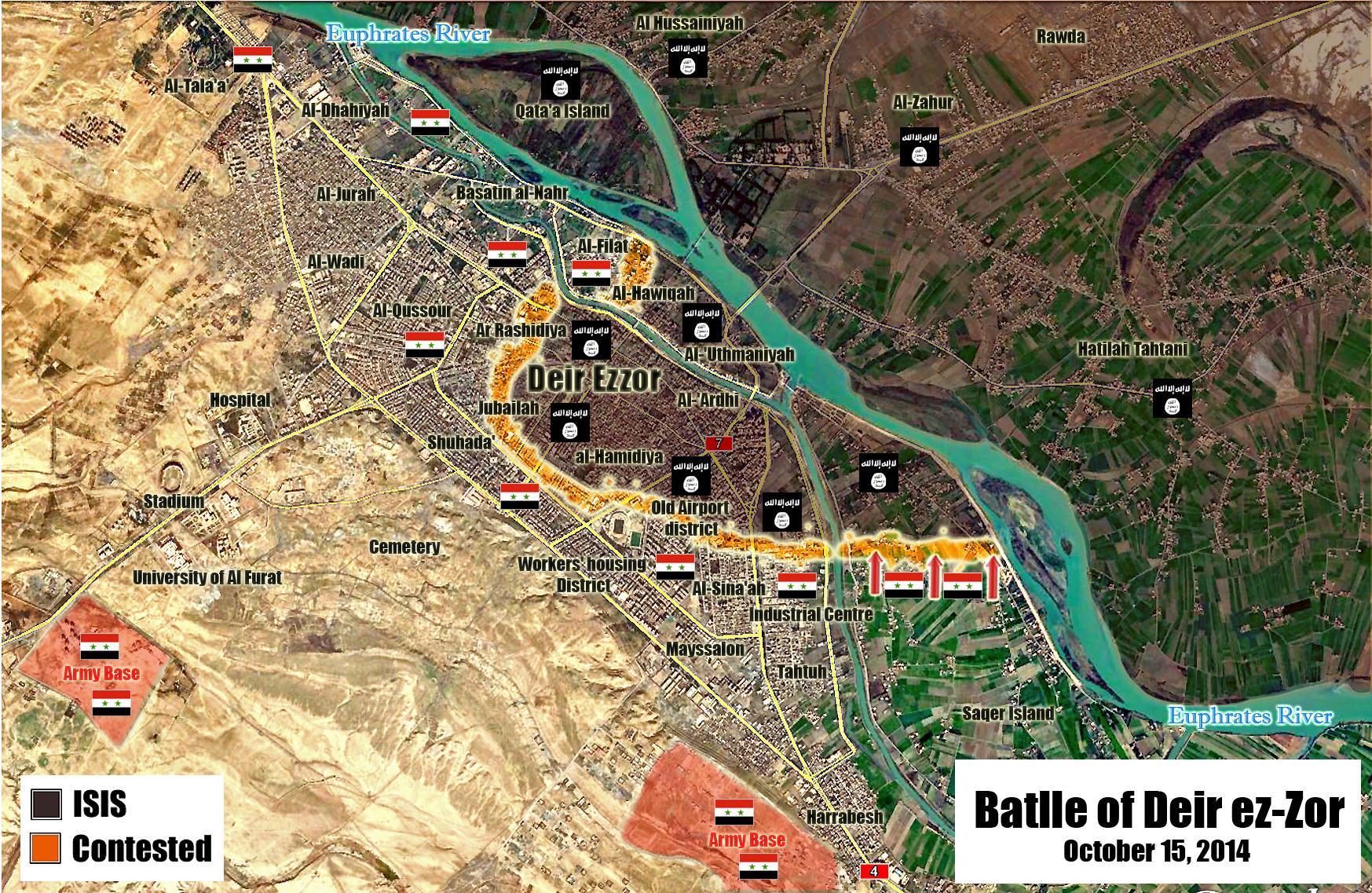
Speedy deletion nomination of Iraqi People’s Coalition
Hello MrPenguin20,
I wanted to let you know that I just tagged Iraqi People’s Coalition for deletion, because it's too short to identify the subject of the article.
If you feel that the article shouldn't be deleted and want more time to work on it, you can contest this deletion, but please don't remove the speedy deletion tag from the top.
You can leave a note on my talk page if you have questions. Anupam Talk 02:24, 19 June 2014 (UTC)
Re:Iraqi People's Coalition
Hi User:MrPenguin20, thanks for the message on my talk page. You're welcome! I'm glad everything worked out! With regards, Anupam Talk 07:22, 20 June 2014 (UTC)
Disambiguation link notification for July 5
Hi. Thank you for your recent edits. Wikipedia appreciates your help. We noticed though that when you edited Popular Movement in Iraq, you added a link pointing to the disambiguation page Sahwa. Such links are almost always unintended, since a disambiguation page is merely a list of "Did you mean..." article titles. Read the FAQ • Join us at the DPL WikiProject.
It's OK to remove this message. Also, to stop receiving these messages, follow these opt-out instructions. Thanks, DPL bot ( talk) 08:55, 5 July 2014 (UTC)
Mayda'a in Ghuta
- The city of Mayda'a under army control here confirmation from a reliable source.
Reuters On the map taken from a reliable source specified that the city under the control of the army. Please update this map
Rif Damashq.
Hanibal911 (
talk) 07:33, 7 July 2014 (UTC)
- Thanks - although I noticed this other reuters article from the same day stated that Maydaa was the scene of clashes between ISIS/IS and the Islamic Front. Any ideas what's going on? MrPenguin20 ( talk) 19:28, 7 July 2014 (UTC)
Nice work
Just want to say, your work on flags and graphics is incredible! 71.184.147.211 ( talk) 17:24, 7 July 2014 (UTC)
- Many thanks! :) MrPenguin20 ( talk) 19:28, 7 July 2014 (UTC)
File:Iyad Khalil Zaki.jpeg listed for deletion
A file that you uploaded or altered, File:Iyad Khalil Zaki.jpeg, has been listed at Wikipedia:Files for deletion. Please see the discussion to see why it has been listed (you may have to search for the title of the image to find its entry). Feel free to add your opinion on the matter below the nomination. Thank you. Sfan00 IMG ( talk) 20:29, 14 July 2014 (UTC)
Vostok Battalion SSI & Flag
Another Ukraine request. This paramilitary group has just recently revealed their new SSI and flag before attacking the Donetsk Airport again. Their SSI is at 2:36 https://www.youtube.com/watch?v=N-5FQ2jiSsM The bottom looks like a rising sun, and it has 14 black and 15 orange lines. The shield has a yellow outline and the writing is "БАТАЛЬОН" and "ВОСТОК" with white font. SkoraPobeda ( talk) 23:38, 14 July 2014 (UTC)
- Nice find! On holiday atm, so likely won't have it done before next Friday, but rest assured it shall be done!
MrPenguin20 (
talk) 04:21, 19 July 2014 (UTC)
- Oh of course, take your time. Ramadan Mubarak!
SkoraPobeda (
talk) 15:05, 19 July 2014 (UTC)
- Thanks :). Ramadan Kareem! MrPenguin20 ( talk) 02:19, 20 July 2014 (UTC)
- Oh of course, take your time. Ramadan Mubarak!
SkoraPobeda (
talk) 15:05, 19 July 2014 (UTC)
Update: I found a much sharper flag which cleared up some guesses. 0:38 https://www.youtube.com/watch?v=0_K1kaEqcyg&list=UUuRgUSdmne5RXVGjKuHLBCQ and http://pbs.twimg.com/media/BtPq8O7CMAAZreL.jpg The "ВОСТОК" font is 2x bigger. The shield has a black outline and the symbol is the same as the SSI except the dragon is black. Inside the shield "БАТАЛЬОН" and "ВОСТОК" have black font with white around the letters to make it readable. SkoraPobeda ( talk) 15:22, 20 July 2014 (UTC)
- Thanks! Done them both now. Emblem/SSI available
here. Flag available
here.
MrPenguin20 (
talk) 14:50, 25 July 2014 (UTC)
- As always, you do an outstanding job! I'll let you know if I find any more Ukraine emblems/flags. SkoraPobeda ( talk) 15:58, 25 July 2014 (UTC)
.svg)
.svg)
Operation Dignity
Hey there,
I've been preoccupied by other stuff on Wikipedia in the last two months so I didn't work much on the article, but now I will try to update it as much as I can. I'm also thinking about renaming it because apparently Haftar's operation is now only limited to Benghazi, while Tripoli is also witnessing intense fighting. Do you think you can help?
Fitzcarmalan (
talk) 10:41, 30 July 2014 (UTC)
- Sure! I'll get on it :) MrPenguin20 ( talk) 23:20, 30 July 2014 (UTC)
Al Yadudah
Good day! You can update this map. Battle of Daraa City Because according the data from SOHR it said that violent clashes between the rebel and Islamic battalions against the regime forces on the outskirts of Al Yadudah town. SOHR Hanibal911 ( talk) 17:03, 11 August 2014 (UTC)
- Thanks! I'll get on it :)
MrPenguin20 (
talk) 01:23, 13 August 2014 (UTC)
- You probably forgot?
Hanibal911 (
talk) 08:17, 16 August 2014 (UTC)
- I didn't forget :P. I was trying to find any other Daraa maps that suggested other changes between the last update and now (also to give an idea of where the Yadoda advance was coming from). Didn't find much though, so I've just done the Yadoda update for now, and assumed the advance has been SAA from Daraa.
MrPenguin20 (
talk) 11:09, 16 August 2014 (UTC)
- You did everything right. Thank you! Hanibal911 ( talk) 11:30, 16 August 2014 (UTC)
- I didn't forget :P. I was trying to find any other Daraa maps that suggested other changes between the last update and now (also to give an idea of where the Yadoda advance was coming from). Didn't find much though, so I've just done the Yadoda update for now, and assumed the advance has been SAA from Daraa.
MrPenguin20 (
talk) 11:09, 16 August 2014 (UTC)
- You probably forgot?
Hanibal911 (
talk) 08:17, 16 August 2014 (UTC)
A barnstar for you!

|
The Original Barnstar |
| Thank you for the impressive work you did on the Libyan conflict article and for creating new articles about some of the militias involved in the fighting. Fitzcarmalan ( talk) 22:15, 15 August 2014 (UTC) |
And sorry for not paying enough attention to the article in the last few days. I was quite busy in real life but now I'm completely free. Cheers! Fitzcarmalan ( talk) 22:18, 15 August 2014 (UTC)
- No problem! Tbh I don't think many major things have been happening lately - just essentially clashes here and there. Besides, given that you've written so much of the page, if anything it should be me apologizing for being absent! MrPenguin20 ( talk) 11:19, 16 August 2014 (UTC)
A barnstar for you!

|
The Editor's Barnstar |
| This is your reward for a great job of making maps for articles in Wikipedia. Hanibal911 ( talk) 11:34, 16 August 2014 (UTC) |
- Thanks :P. Although I must say I think the real credit goes to you for helping keeping me updated! MrPenguin20 ( talk) 13:57, 16 August 2014 (UTC)
Sadiq Al-Ghariani
Sadiq Al-Ghariani already existed 6 days before you created
Sadik al-Ghariani! We should merge. The most common transliteration for
ق is q.
Contributorzero (
talk) 08:53, 31 August 2014 (UTC)
- How the heck did I miss that. Oh well my bad. Yes let's merge them - yours is better referenced anyways. MrPenguin20 ( talk) 12:35, 31 August 2014 (UTC)
Libya conflict map
Is the new Libya conflict map from you? Contributorzero ( talk) 21:10, 1 September 2014 (UTC)
- No that's not mine - got two in the works though focusing on Benghazi & Tripoli which aim to highlight important areas instead of trying to give a definitive idea of who controls where - as you rightly pointed out, if we tried to do that then we'd essentially end up simplifying the conflict too much and the map would therefore likely be wrong/not really provide any accurate information. MrPenguin20 ( talk) 21:42, 1 September 2014 (UTC)
Reviewing United Kingdom general election, 1885 (Ireland)
I am a new page patroller and I am wondering why you don't have any references for this article. Do you have plans to go back and create some references? I have discovered that new pages that have no references are often deleted, but I am not going to nominate this article for deletion. It seems like a good article, and has the potential of providing information that would be useful to people.
- Bfpage | leave a message 00:19, 30 September 2014 (UTC)
- Yeah originally I noticed that there were a couple of articles relating to general election results in Ireland, and decided to make some electoral maps for them. Then I started attempting to join up the various isolated articles ( 1859, 1874, 1880, 1910 (Dec), 1918). You're totally right though - I got ahead of myself, and the new articles need sources. I've got sources for the seats/vote figures (Rallings & Thrasher), but the real content of the articles themselves need fleshing out. I'll refocus on consolidating, expanding, and referencing the existing articles. MrPenguin20 ( talk) 00:32, 30 September 2014 (UTC)
Siege of Kobane
You can update this map Siege of Kobane or you may create new map. What would this map showed the current situation in this area in accordance with the data of the map. Syrian Civil War detailed map And also here very nice source which very accurately showed the situation in this area. here. Also map from BBC confirmed the data on this map Hanibal911 ( talk) 09:44, 30 September 2014 (UTC)
- Cool - shall update these tomorrow.
MrPenguin20 (
talk) 00:25, 1 October 2014 (UTC)
- Here new version the
mapwhich show situation in this area.
Hanibal911 (
talk) 14:25, 2 October 2014 (UTC)
- You can change this map Siege of Kobane that would map showed more detail the situation in the city of Kobane. Here new version map which showed situation in the city and surrounding area. map Hanibal911 ( talk) 07:13, 28 October 2014 (UTC)
- Here new version the
mapwhich show situation in this area.
Hanibal911 (
talk) 14:25, 2 October 2014 (UTC)
Irish Unionist Alliance
No problem! Hopefully the article is a little more useful than it was three days ago! WatermillockCommon ( talk) 21:46, 4 October 2014 (UTC)
- It certainly looks so! I often do graphics work for wikipedia, and I was wondering if in any of the readings on the UIA (or the UAPL) there'd been any mention of a party logo/emblem of any kind?
MrPenguin20 (
talk) 21:51, 4 October 2014 (UTC)
- Not that I have come across... it would be great if there was one that could be added though. I will have a look through some of the campaign literature and see if I can find something, and let you know.
WatermillockCommon (
talk) 21:54, 4 October 2014 (UTC)
- That would be awesome - many thanks! MrPenguin20 ( talk) 21:55, 4 October 2014 (UTC)
- Not that I have come across... it would be great if there was one that could be added though. I will have a look through some of the campaign literature and see if I can find something, and let you know.
WatermillockCommon (
talk) 21:54, 4 October 2014 (UTC)
A barnstar for you!

|
The Teamwork Barnstar |
| For your recent additions at Revolutionary Council of Islamic Unity of Afghanistan, as well as other articles on Afghan civil war. Well done! GreyShark ( dibra) 19:27, 18 October 2014 (UTC) |
- Many thanks :). MrPenguin20 ( talk) 11:59, 19 October 2014 (UTC)
Battle of Daraa City
You can noted the city of Umm al Mayadin as contested on this map. Battle of Daraa City source source
- Shall update tomorrow!
MrPenguin20 (
talk) 03:39, 20 October 2014 (UTC)
- Yet it would be better noted this city as a contested.
Hanibal911 (
talk) 06:31, 21 October 2014 (UTC)
- Rebels captured city Umm al Mayadin and the area around the city.
source also rebels captured the city Nassib.
source
Hanibal911 (
talk) 17:48, 21 October 2014 (UTC)
- Updated. Nasib is just out of range of the map.
MrPenguin20 (
talk) 19:08, 21 October 2014 (UTC)
- SOHR reported that violent clashes are taking place between the regime forces and the Islamic battalions in Daraa al- Balad. source You can noted this area as contested! Hanibal911 ( talk) 08:10, 25 October 2014 (UTC)
- Updated. Nasib is just out of range of the map.
MrPenguin20 (
talk) 19:08, 21 October 2014 (UTC)
- Rebels captured city Umm al Mayadin and the area around the city.
source also rebels captured the city Nassib.
source
Hanibal911 (
talk) 17:48, 21 October 2014 (UTC)
- to according to data from pro opposition
source city
[5] to west of city Dara still contested between Syrian troops and rebels.
Hanibal911 (
talk) 21:13, 8 November 2014 (UTC)
- According to data from antigovernment source the city of Atman to north of city Daraa still contested between Syrian troops and rebels. here Please update a map! Hanibal911 ( talk) 12:16, 13 January 2015 (UTC)
- Yet it would be better noted this city as a contested.
Hanibal911 (
talk) 06:31, 21 October 2014 (UTC)
- Please update a map.
Hanibal911 (
talk) 22:29, 21 January 2015 (UTC)
- Atman still contested. Violent clashes had taken place between the regime forces in Islamic battalions in the town Atman.
SOHR
Hanibal911 (
talk) 11:19, 30 January 2015 (UTC)
- I'd say it currently is marked as contested. Atman's quite a long town, stretching from a little north of the military base to the west of the town to the military base that's JUST north-east of Daraa city. So that entire area is Atman, and whilst parts of it are contested, other parts aren't (opposition controls northern Atman, Govt controls southern Atman, with clashes in the centre). I could change the whole Atman area to contested, but I think maybe the current arrangement probably is most accurate.
MrPenguin20 (
talk) 10:59, 31 January 2015 (UTC)
- The town of
Atman near city of Dara not under control by rebels. Here pro opposition source reported that FSA shelled regime forces in the town of Atman in Daraa.
Qasion News So need marked this town as contested.
Hanibal911 (
talk) 21:00, 27 February 2015 (UTC)
- The map showed Atman as being contested. Like I said the town is larger than the most concentrated grouping of houses. I've updated it to show the entirety of Atman as being contested now. MrPenguin20 ( talk) 19:01, 28 February 2015 (UTC)
- The town of
Atman near city of Dara not under control by rebels. Here pro opposition source reported that FSA shelled regime forces in the town of Atman in Daraa.
Qasion News So need marked this town as contested.
Hanibal911 (
talk) 21:00, 27 February 2015 (UTC)
- I'd say it currently is marked as contested. Atman's quite a long town, stretching from a little north of the military base to the west of the town to the military base that's JUST north-east of Daraa city. So that entire area is Atman, and whilst parts of it are contested, other parts aren't (opposition controls northern Atman, Govt controls southern Atman, with clashes in the centre). I could change the whole Atman area to contested, but I think maybe the current arrangement probably is most accurate.
MrPenguin20 (
talk) 10:59, 31 January 2015 (UTC)
- Atman still contested. Violent clashes had taken place between the regime forces in Islamic battalions in the town Atman.
SOHR
Hanibal911 (
talk) 11:19, 30 January 2015 (UTC)
- Thank you very much for your work on improving our maps! Hanibal911 ( talk) 19:40, 28 February 2015 (UTC)
Rif Aleppo 2
You can update this map. Rif Aleppo 2 Because SOHR reported that the regime forces supported by allies took control the village of al Jbayleh and the cement plant in north of the Central Prison of Aleppo. hereAlso army capturing al Muslimiyah [6]. sourceHere a map from the pro government source but this source only for that would to see where some objects are located. Hanibal911 ( talk) 06:50, 20 October 2014 (UTC)
![[6]](https://pbs.twimg.com/media/B0U0S2eCYAAOUsr.jpg:large)
- Looks like Kami's done it. Might update though to mark down certain places of interest.
MrPenguin20 (
talk) 19:18, 21 October 2014 (UTC)
- Syrian troops has captured the whole
al-Brej area
Al Jazeera.
- A pro-government source
[7] reported the SAA captured the
al-Mallah area while
SOHR and neutral
Elijah J.Magnier reported the army advanced into it. So at the very least it should be marked as contested while the Mazra'a Halabi area to the east of it should be marked as Syrian troops held. Further credence to the capture of Mazra'a Halabi can be found in today's report
here that the area east of al-Mallah has been captured by the troops. Also, neutral source
Elijah J.Magnier reported the SAA captured the south and west of the Handarat city district. SOHR also confirmed
[8], that Syrian troops has captured al-Mallah and are attempting to advance on west.
Hanibal911 (
talk) 08:04, 15 December 2014 (UTC)
- Working on it! MrPenguin20 ( talk) 02:14, 16 December 2014 (UTC)
- A pro-government source
[7] reported the SAA captured the
al-Mallah area while
SOHR and neutral
Elijah J.Magnier reported the army advanced into it. So at the very least it should be marked as contested while the Mazra'a Halabi area to the east of it should be marked as Syrian troops held. Further credence to the capture of Mazra'a Halabi can be found in today's report
here that the area east of al-Mallah has been captured by the troops. Also, neutral source
Elijah J.Magnier reported the SAA captured the south and west of the Handarat city district. SOHR also confirmed
[8], that Syrian troops has captured al-Mallah and are attempting to advance on west.
Hanibal911 (
talk) 08:04, 15 December 2014 (UTC)
- Syrian troops has captured the whole
al-Brej area
Al Jazeera.
- Syrian troops had captured all of the al-Malah area as well areas south and west of Handarat town in the countryside.
Hot News Online
Reuters Also Syrian army recaptures hill overlooking resupply road from Turkey to Aleppo in fierce fighting.
Joshua Landis
Hanibal911 (
talk) 09:27, 16 December 2014 (UTC)
- Syrian army now has consolidated its position on distance 2-3 km from city
Haritan.
Elijah J.Magnier So that please update map according to data which I provide you. Also here pro government map which show situation in this area.
here Just small clarification for this map! Sheikh Maqsoud controlled by Kurds.
here
Hanibal911 (
talk) 20:24, 16 December 2014 (UTC)
- Looks like Kami's just done it. I'd agree with his edits - it looks pretty similar to the version I was about to upload.
MrPenguin20 (
talk) 00:01, 17 December 2014 (UTC)
- SOHR confirmed
here that Syrian army recaptured Aghob hill and the al-Fawaz area of al-Brej
here. Also pro-opposition map
here confirms that all of Salahadine and Saif al-Dawla districts, except for the lower right corner (contested), are Syrian armt-held.
Hanibal911 (
talk) 11:57, 18 December 2014 (UTC)
- Pro opposition
source reported that Syrian troops captured all
Handarat district
Hanibal911 (
talk) 17:54, 18 December 2014 (UTC)
- I've changed Aghob hill to govt control. I think al-Fawaz is already marked as being under govt control. Edited the front around Salahuddin/al-Dawla, around the differences between the maps were minimal (in both the front follows the road passed Aleppo Intl Stadium, and then runs along the edge of Saif al-Dawla. Not changed Handarat yet - figured such a change in control would be relatively newsworthy and I've not seen any mention of it elsewhere yet, although I'll keep an eye out.
MrPenguin20 (
talk) 00:13, 19 December 2014 (UTC)
- SOHR has confirmed the capture of at least part of the Handarat district [9]. So I would mark that rebel bulge in SAA lines from Aghob hill up until the Handarat district as government-held now as well as at least the northern part of Handarat here [10]. EkoGraf ( talk) 04:09, 19 December 2014 (UTC)
- I've changed Aghob hill to govt control. I think al-Fawaz is already marked as being under govt control. Edited the front around Salahuddin/al-Dawla, around the differences between the maps were minimal (in both the front follows the road passed Aleppo Intl Stadium, and then runs along the edge of Saif al-Dawla. Not changed Handarat yet - figured such a change in control would be relatively newsworthy and I've not seen any mention of it elsewhere yet, although I'll keep an eye out.
MrPenguin20 (
talk) 00:13, 19 December 2014 (UTC)
- Pro opposition
source reported that Syrian troops captured all
Handarat district
Hanibal911 (
talk) 17:54, 18 December 2014 (UTC)
- SOHR confirmed
here that Syrian army recaptured Aghob hill and the al-Fawaz area of al-Brej
here. Also pro-opposition map
here confirms that all of Salahadine and Saif al-Dawla districts, except for the lower right corner (contested), are Syrian armt-held.
Hanibal911 (
talk) 11:57, 18 December 2014 (UTC)
- Looks like Kami's just done it. I'd agree with his edits - it looks pretty similar to the version I was about to upload.
MrPenguin20 (
talk) 00:01, 17 December 2014 (UTC)
- Syrian army now has consolidated its position on distance 2-3 km from city
Haritan.
Elijah J.Magnier So that please update map according to data which I provide you. Also here pro government map which show situation in this area.
here Just small clarification for this map! Sheikh Maqsoud controlled by Kurds.
here
Hanibal911 (
talk) 20:24, 16 December 2014 (UTC)
- Reliable source(
Edward Dark journalist who writes articles for reliable sources
Al Monitoe and
Middle East Eye) reported that Handarat Camp is fully under regime control. The siege of east Aleppo city is now complete.
here
Hanibal911 (
talk) 11:26, 19 December 2014 (UTC)
- I awaited a little while to see if this was reported elsewhere, but as it hasn't I think Dark spoke too soon - if eastern Aleppo was surrounded/cut-off then I think it'd probably receive some degree of wider media coverage. I wasn't sure about he SOHR thing cause they stated that govt forces could advance, but their Facebook seems more certain on the matter, and states the govt forces did advance. It's not really clear where the advance took place, so what I've done is largely marked Handarat as a whole to be contested. MrPenguin20 ( talk) 18:35, 21 December 2014 (UTC)
- You can update the map because army launched a major offensive in Alepoo and captured villages
Rityan and
Hardantain and
Bashkuy This confirmed pro opposition sources
Archicivilians
Abdel Rahman
here
Abdel Rahman Also pro opposition ource siad that Rebels and Kurds in Aleppo cut off from most supply lines after Syrian troop stormed areas.
here And that today Syrian troops closed siege ring in Aleppo and all Sunni arabic-forces (FSA/IF) & kurdish forces now trapped.
here
Hanibal911 (
talk) 08:34, 17 February 2015 (UTC)
- Syrian army backed by allied militia has captured the villages Rityan, Hardantain and Bashkuy north of Aleppo from rebels and blocked a main supply route leading into the northern city amid heavy fighting.
Reuters
The Daily Star
Viva Revolt
Hanibal911 (
talk) 10:38, 17 February 2015 (UTC)
- SOHR confirmed that army captured villages of Bashkuy SOHR and Rityan SOHR and now clashes in east the village Bayanoon. Also another pro oppositio sources reported that Syrian regular troops advancing in the countryside north of Aleppo, and take control the towns Rityan, Hardantain and Bashkuy. Syria Newsdesk Hanibal911 ( talk) 12:55, 17 February 2015 (UTC)
- SAA has advanced further past Rityan and is fighting on the road towards Bayanoon
[11] somewhere here
[12] I suppose.
EkoGraf (
talk) 12:53, 17 February 2015 (UTC)
- Another reliable source also confirmed that Syrian troops take control villages Rityan, Hardantain and Bashkuy. Elijah J. Magnier and now Syrian army and Hezbollah advance from Shihan al-Maamel toward sheikh Maqsud in Aleppo and from Castello to al-Mallah. Elijah J. Magnier Hanibal911 ( talk) 13:57, 17 February 2015 (UTC)
- Syrian army backed by allied militia has captured the villages Rityan, Hardantain and Bashkuy north of Aleppo from rebels and blocked a main supply route leading into the northern city amid heavy fighting.
Reuters
The Daily Star
Viva Revolt
Hanibal911 (
talk) 10:38, 17 February 2015 (UTC)
- Also pro opposition source reported that fierce clashes between FSA and regime forces in Handarat Camp Local Coordination Committees of Syria Hanibal911 ( talk) 14:41, 17 February 2015 (UTC)
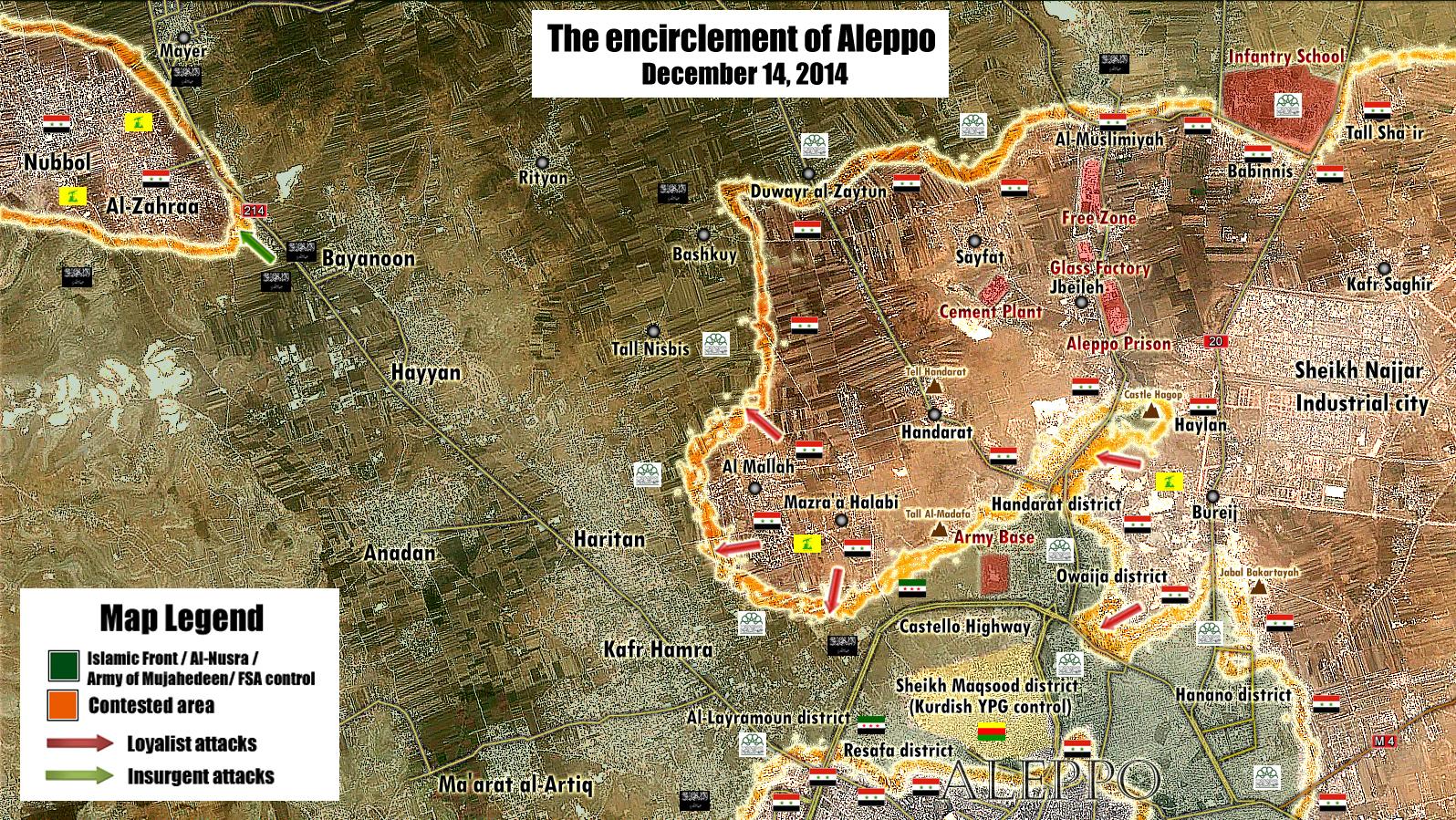
The Dwer Zaytoun area has also become contested [13]. Location here [14]. EkoGraf ( talk) 16:04, 17 February 2015 (UTC)
So lets summarize: the southern edge of Dwer Zaytoun and western edge of the Handarat camp contested [15]. Rityan and Bashkuy are now SAA-held. And the contested frontline now located somewhere on the road between Rityan and Bayanoon. SOHR's last report about Hardetin was that it was still contested and just now a military source [16] confirmed they were fighting for a third village (most likely Hardetin), so it is still contested, but it actually doesn't matter for this map because its outside its range. EkoGraf ( talk) 16:07, 17 February 2015 (UTC)
- Also pro opposition map showed that Duwayr al-Zaytun contested.
here
Hanibal911 (
talk) 18:38, 17 February 2015 (UTC)
- On it!
MrPenguin20 (
talk) 02:32, 18 February 2015 (UTC)
- Pro opposition source reported that clashes in the
Khan al-Asal
Shu'ayb al-Yazdi
Hanibal911 (
talk) 09:15, 18 February 2015 (UTC)
- I think Kami fixed the bulk of issues there by added the results of the recent offensive, but I've added in the villages etc to make it clearer, as well as shown the current areas of fighting in the areas. Also added the Khan al-Asal fighting (any idea of whether its in the town proper or just in the wider area?). MrPenguin20 ( talk) 01:57, 19 February 2015 (UTC)
- Pro opposition source reported that clashes in the
Khan al-Asal
Shu'ayb al-Yazdi
Hanibal911 (
talk) 09:15, 18 February 2015 (UTC)
- On it!
MrPenguin20 (
talk) 02:32, 18 February 2015 (UTC)
- Also rebel liader confirmed that village of Dweir al Zaytun still contested between Syrian troops and rebels and village of Bashkuy under control by army.
here And SOHR confirmed that clashes near village Rityan and in Hardatin.
SOHR So your map is properly reflect the situation in the area.
Hanibal911 (
talk) 18:01, 19 February 2015 (UTC)
- Makes a first :P
MrPenguin20 (
talk) 00:47, 20 February 2015 (UTC)
- SOHR reported that Jabhat al-Nusra and Islamic battalions have taken over
al-Mallah farmlands
SOHR
Hanibal911 (
talk) 17:12, 20 February 2015 (UTC)
- But reporter Khaled Iskef states that village Hanadarat and al Mallah farms are still in control of Syrian army and rebels only take 2 out of 48 farms. here Hanibal911 ( talk) 17:21, 20 February 2015 (UTC)
- SOHR reported that Jabhat al-Nusra and Islamic battalions have taken over
al-Mallah farmlands
SOHR
Hanibal911 (
talk) 17:12, 20 February 2015 (UTC)
- Makes a first :P
MrPenguin20 (
talk) 00:47, 20 February 2015 (UTC)
- This new version of map.
here
Hanibal911 (
talk) 20:26, 20 February 2015 (UTC)
- Thanks! Shall update this tonight!
MrPenguin20 (
talk) 11:54, 21 February 2015 (UTC)
- A small clarification Syrian troops and NDF withdrew from the village
Hardatin after rebels cut the supply line to the village.
Rida Albasha
Hanibal911 (
talk) 12:09, 21 February 2015 (UTC)
- Here is an updated map showing the situation in Aleppo. here Hanibal911 ( talk) 18:22, 21 February 2015 (UTC)
- A small clarification Syrian troops and NDF withdrew from the village
Hardatin after rebels cut the supply line to the village.
Rida Albasha
Hanibal911 (
talk) 12:09, 21 February 2015 (UTC)
- Thanks! Shall update this tonight!
MrPenguin20 (
talk) 11:54, 21 February 2015 (UTC)
- Thank you for updating map. But you would not be able to make a small clarification on the map because Duwayr al Zaytun still contested but not under control of the rebels. Thanks!
Hanibal911 (
talk) 11:43, 25 February 2015 (UTC)
- Sorry been a bit busy this week. I'll get on it!
MrPenguin20 (
talk) 15:27, 27 February 2015 (UTC)
- Updated!
MrPenguin20 (
talk) 19:38, 28 February 2015 (UTC)
- According to data from the Human Rights Watch the districts of (Salah al-Din, Sayf al-Dawla, Sa'ad al-Ansari, Ard as-Sabbagh, Ramouseh, Jabal al-Ghazzalat, Masharqa ) under control by Syrian troops. If I forgot something specify so here is the card that shows the areas which is under full control of army on 25 January. Human Rights Watch Hanibal911 ( talk) 20:14, 1 March 2015 (UTC)
- On it!
MrPenguin20 (
talk) 18:43, 3 March 2015 (UTC)
- Pro-opposition video confirmed that the Duwar al Zaytoun is under control of Syrian troops. [17] [18] So you can mark it under control by Syrian army. Hanibal911 ( talk) 07:44, 8 March 2015 (UTC)
- Updated!
MrPenguin20 (
talk) 19:38, 28 February 2015 (UTC)
- Sorry been a bit busy this week. I'll get on it!
MrPenguin20 (
talk) 15:27, 27 February 2015 (UTC)
- So if you have time can you update the maps.
Hanibal911 (
talk) 11:37, 8 March 2015 (UTC)
- The village of
Handarat under control by Al Nusra and Islamic battalions. Clashes still continued in the vicinity of
Tall Handarat and village of
Bashkuy
SOHR
SOHR Tall Handarat and Bashkuy still under control by Syrian troops and thrit allies.
Hanibal911 (
talk) 18:50, 9 March 2015 (UTC)
- I would ask that Handarat be marked contested or the northern half be marked as SAA-held and southern half as rebel-held with the frontline going through the middle of the town. Because, original Arabic SOHR report
[19] said rebels were almost in control of the entire village (so not all), pro-government Masdar
[20] said only a couple of buildings in the southern part were captured and heavily pro-opposition Syria Direct
[21] in fact says the rebels captured only 40 percent of the village and that the fighting was concentrated in the village center.
EkoGraf (
talk) 05:30, 10 March 2015 (UTC)
- No problemo
MrPenguin20 (
talk) 10:57, 10 March 2015 (UTC)
- But SOHR not said that the hill of
Tall al Maqla‘ was captured by rebels.
Hanibal911 (
talk) 09:22, 11 March 2015 (UTC)
- Also about situation in the village of Handarat. Here pro opposition map which released the Ahrar alSham and showing the northern part and some buildings in the west part of village still under control by Syrian troops. But rebels control southern and central parts. here Hanibal911 ( talk) 10:04, 11 March 2015 (UTC)
- But SOHR not said that the hill of
Tall al Maqla‘ was captured by rebels.
Hanibal911 (
talk) 09:22, 11 March 2015 (UTC)
- No problemo
MrPenguin20 (
talk) 10:57, 10 March 2015 (UTC)
- I would ask that Handarat be marked contested or the northern half be marked as SAA-held and southern half as rebel-held with the frontline going through the middle of the town. Because, original Arabic SOHR report
[19] said rebels were almost in control of the entire village (so not all), pro-government Masdar
[20] said only a couple of buildings in the southern part were captured and heavily pro-opposition Syria Direct
[21] in fact says the rebels captured only 40 percent of the village and that the fighting was concentrated in the village center.
EkoGraf (
talk) 05:30, 10 March 2015 (UTC)
- The village of
Handarat under control by Al Nusra and Islamic battalions. Clashes still continued in the vicinity of
Tall Handarat and village of
Bashkuy
SOHR
SOHR Tall Handarat and Bashkuy still under control by Syrian troops and thrit allies.
Hanibal911 (
talk) 18:50, 9 March 2015 (UTC)
- Here new map which showed situation about village of Handarat.
here
Hanibal911 (
talk) 14:30, 11 March 2015 (UTC)
- Pro-opposition source said that Syrian troops attack village
Kafr Hamra tonight and said that they coming from southern fields.
here Need make updates on map!
Hanibal911 (
talk) 20:56, 11 March 2015 (UTC)
- Updated! As the situation in Kafr Hamra is unclear, what I've done is moved the *contested* zone closer to Kafr Hamra (encapsulating the southern fields) without including the city proper. Naturally though I'll update it if it gets more coverage and the SAA seems to be pushing into the town itself. As for Handarat I think the maps seem to show generally the same thing, although I've made a couple changes in regards to Nuqat al-Islamat. Not seen any explicit mention of Tall al-Maqlat, although this map seems to heavily imply its in opposition hands, as otherwise there'd be some kind of large pocket just to the south of the map (which is unlikely). I also fixed the area around the Handarat District, so its more in line with the map seen here by Peto Lucem. The issue was that the boundaries of the urban area weren't previously identified on the map, so the frontline around there was following the wrong path. The outline of Handarat has now been added (along with al-Manasher), so the map should be accurate now. MrPenguin20 ( talk) 22:58, 11 March 2015 (UTC)
- Pro-opposition source said that Syrian troops attack village
Kafr Hamra tonight and said that they coming from southern fields.
here Need make updates on map!
Hanibal911 (
talk) 20:56, 11 March 2015 (UTC)
- Thank you for your timely updates!
Hanibal911 (
talk) 07:11, 12 March 2015 (UTC)
- Also here the anti-government source also confirmed data which provide
EkoGraf which said that rebels captured only approximately 40 percent of the village Handarat.
here So this confirms the fact that a large part of the village is still under the control of the army. Also military source rported that the battle for Handarat and Bashkoy in northern Aleppo has not produced the kind of results the rebel forces expected. Al-Nusra in cooperation with Jaysh Al-Mujahiddeen and Ahrar Al-Sham were unable achieve any progress in the village of Handarat on Wednesday, due to the heavy bombardment from the Syrian Air Force and the heavy resistance encountered from the NDF. Later NDF launch a counter-attack into the southern sector of Handarat that resulted in the capture of a building under Jabhat Al-Nusra control.
here
Hanibal911 (
talk) 14:19, 12 March 2015 (UTC)
- Here more data about situation in the village of Handarat from pro government source
here also pro opposition source reported that Syrian troops launch offensive in southern part Handarat aiming to take back the south part of this village.
here Also SOHR reported that Syrian troops advance in this area.
SOHR
Hanibal911 (
talk) 15:55, 12 March 2015 (UTC)
- Also here new map here Hanibal911 ( talk) 19:56, 12 March 2015 (UTC)
- I'll get on it!
MrPenguin20 (
talk) 12:55, 13 March 2015 (UTC)
- Syrian troops regain control of the village Handarat.
SOHR
The Daily Star
Reuters So need mark this village under control of Syrian troops.
Hanibal911 (
talk) 13:24, 18 March 2015 (UTC)
- Here new map. here Hanibal911 ( talk) 19:07, 18 March 2015 (UTC)
- Here another one the new map which showed situation near village of Handarat which was reteken by Syrian troops. here Hanibal911 ( talk) 10:04, 19 March 2015 (UTC)
- Syrian troops regain control of the village Handarat.
SOHR
The Daily Star
Reuters So need mark this village under control of Syrian troops.
Hanibal911 (
talk) 13:24, 18 March 2015 (UTC)
- Here more data about situation in the village of Handarat from pro government source
here also pro opposition source reported that Syrian troops launch offensive in southern part Handarat aiming to take back the south part of this village.
here Also SOHR reported that Syrian troops advance in this area.
SOHR
Hanibal911 (
talk) 15:55, 12 March 2015 (UTC)
- Also here the anti-government source also confirmed data which provide
EkoGraf which said that rebels captured only approximately 40 percent of the village Handarat.
here So this confirms the fact that a large part of the village is still under the control of the army. Also military source rported that the battle for Handarat and Bashkoy in northern Aleppo has not produced the kind of results the rebel forces expected. Al-Nusra in cooperation with Jaysh Al-Mujahiddeen and Ahrar Al-Sham were unable achieve any progress in the village of Handarat on Wednesday, due to the heavy bombardment from the Syrian Air Force and the heavy resistance encountered from the NDF. Later NDF launch a counter-attack into the southern sector of Handarat that resulted in the capture of a building under Jabhat Al-Nusra control.
here
Hanibal911 (
talk) 14:19, 12 March 2015 (UTC)
- Pro opposition source also confirmed that Syrian troops recaptured
Nuqat al-Isamat
Halabi Farms and now there are clashes in
al-Mallah Farms and at the entrance the village of
Ard al-Mallah
here Syrian troops also recaptured
al-Madafa hill.
SOHR
Hanibal911 (
talk) 19:35, 19 March 2015 (UTC)
- This another map which showed situation in this area.
here
Hanibal911 (
talk) 20:00, 19 March 2015 (UTC)
- Updated! (Finally)
MrPenguin20 (
talk) 15:12, 20 March 2015 (UTC)
- New map for Aleppo. here Hanibal911 ( talk) 19:21, 14 April 2015 (UTC)
- Updated! (Finally)
MrPenguin20 (
talk) 15:12, 20 March 2015 (UTC)
- This another map which showed situation in this area.
here
Hanibal911 (
talk) 20:00, 19 March 2015 (UTC)
- Here new data for update the map:
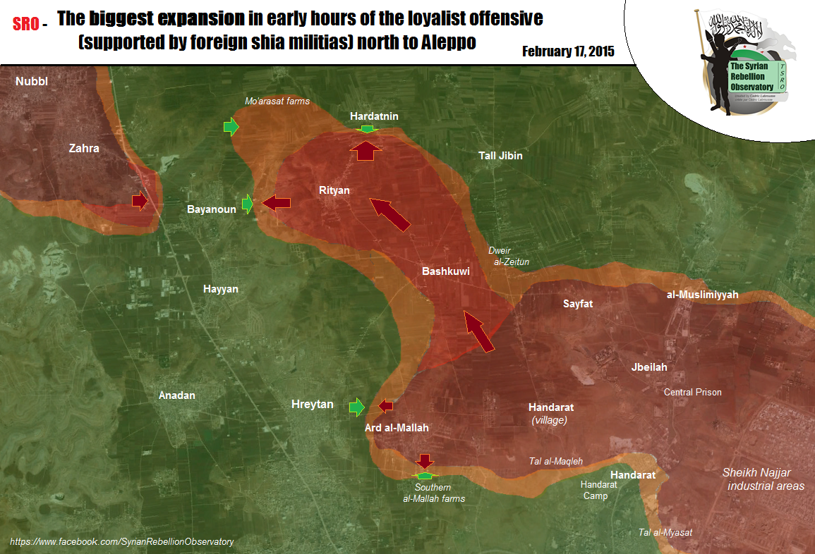
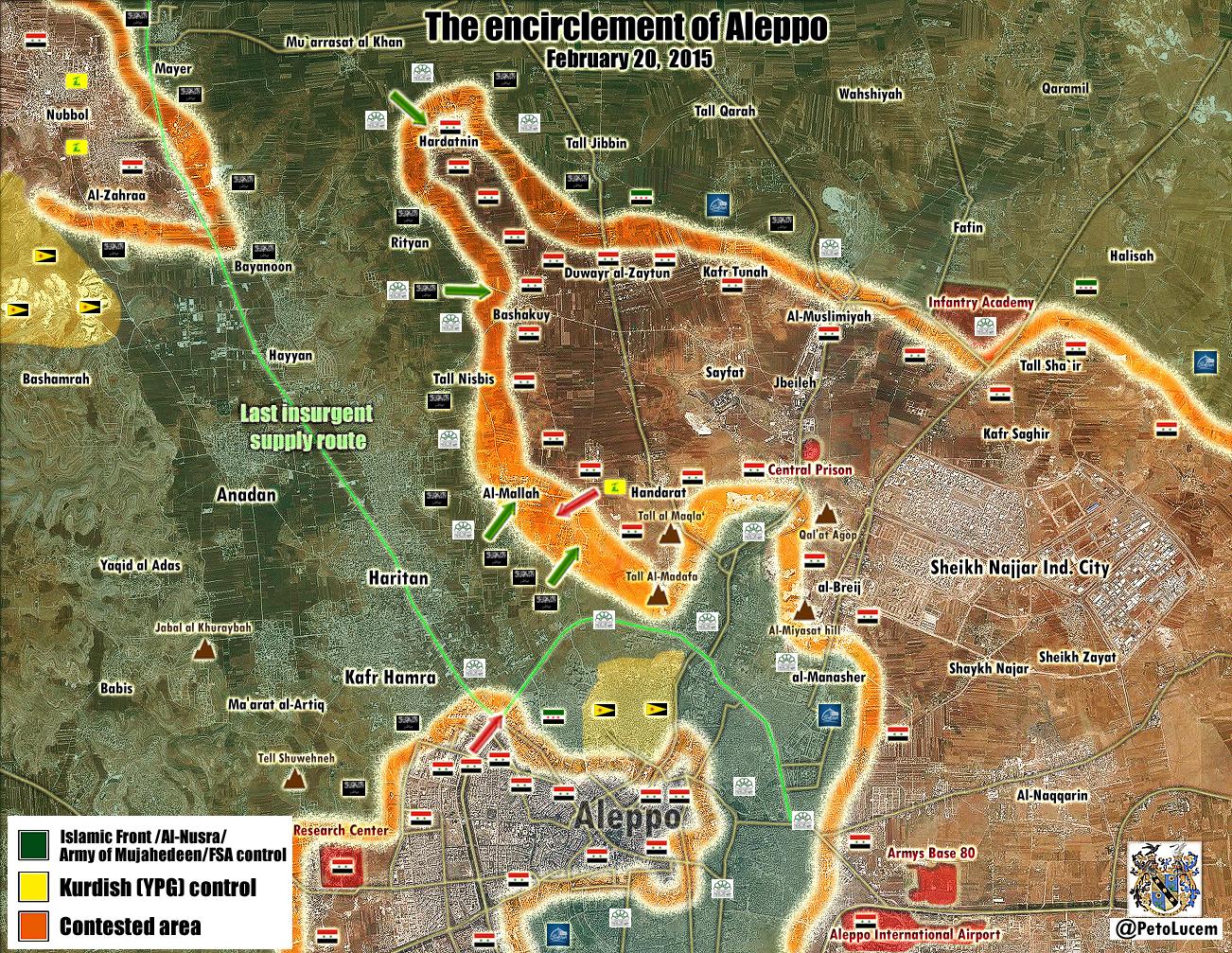
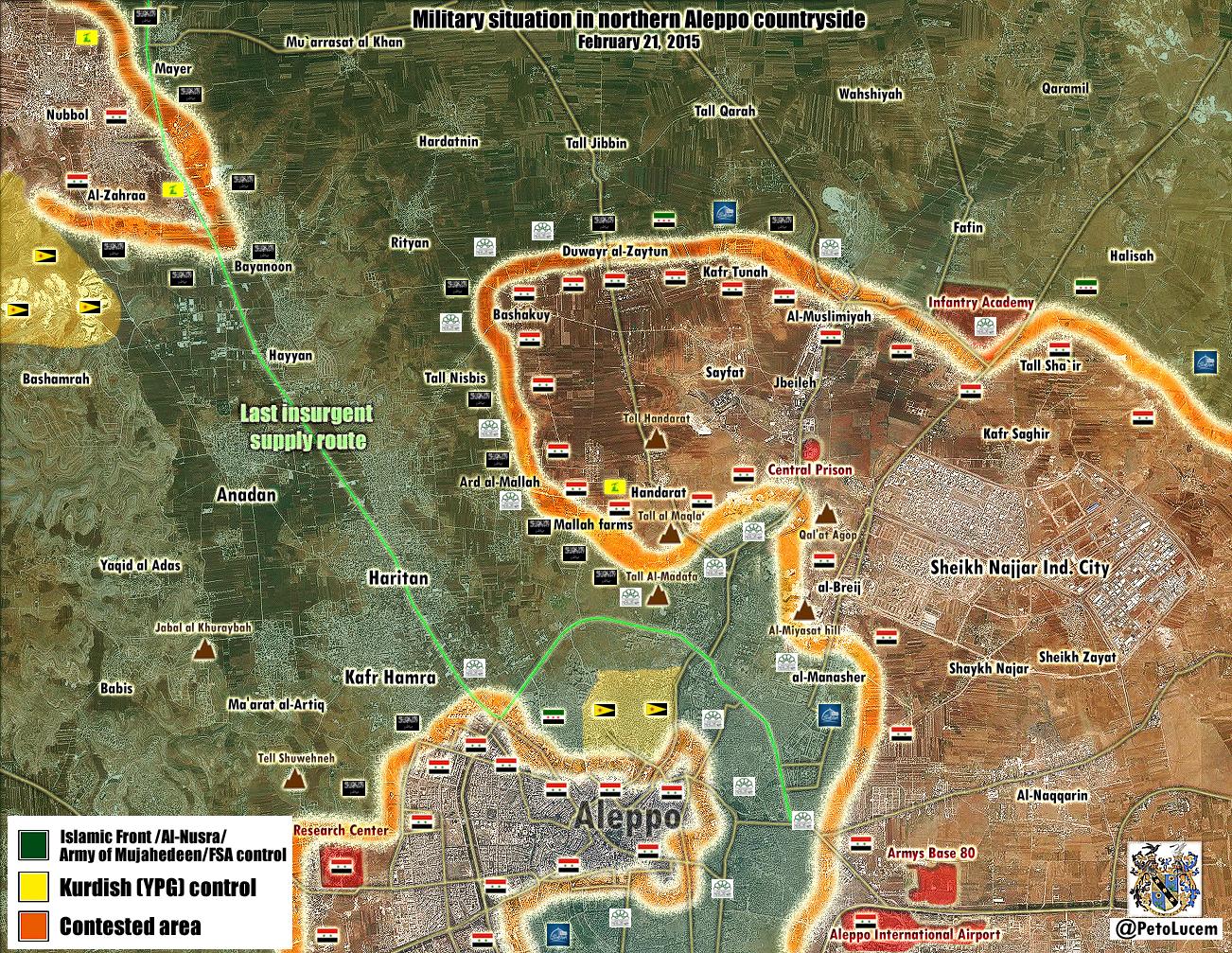
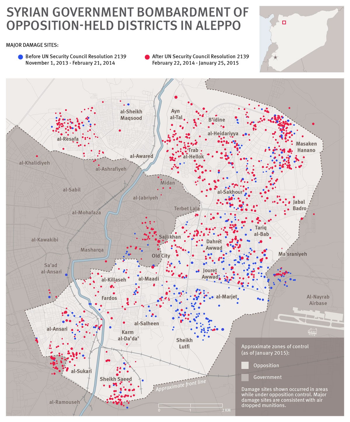
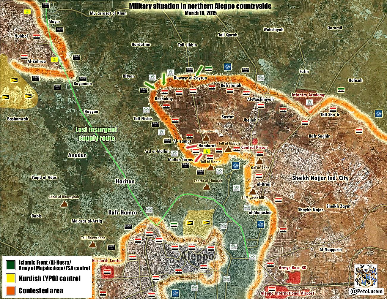
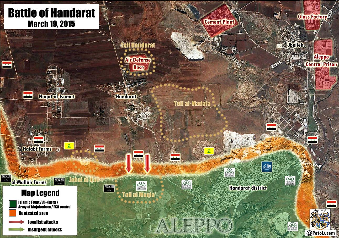
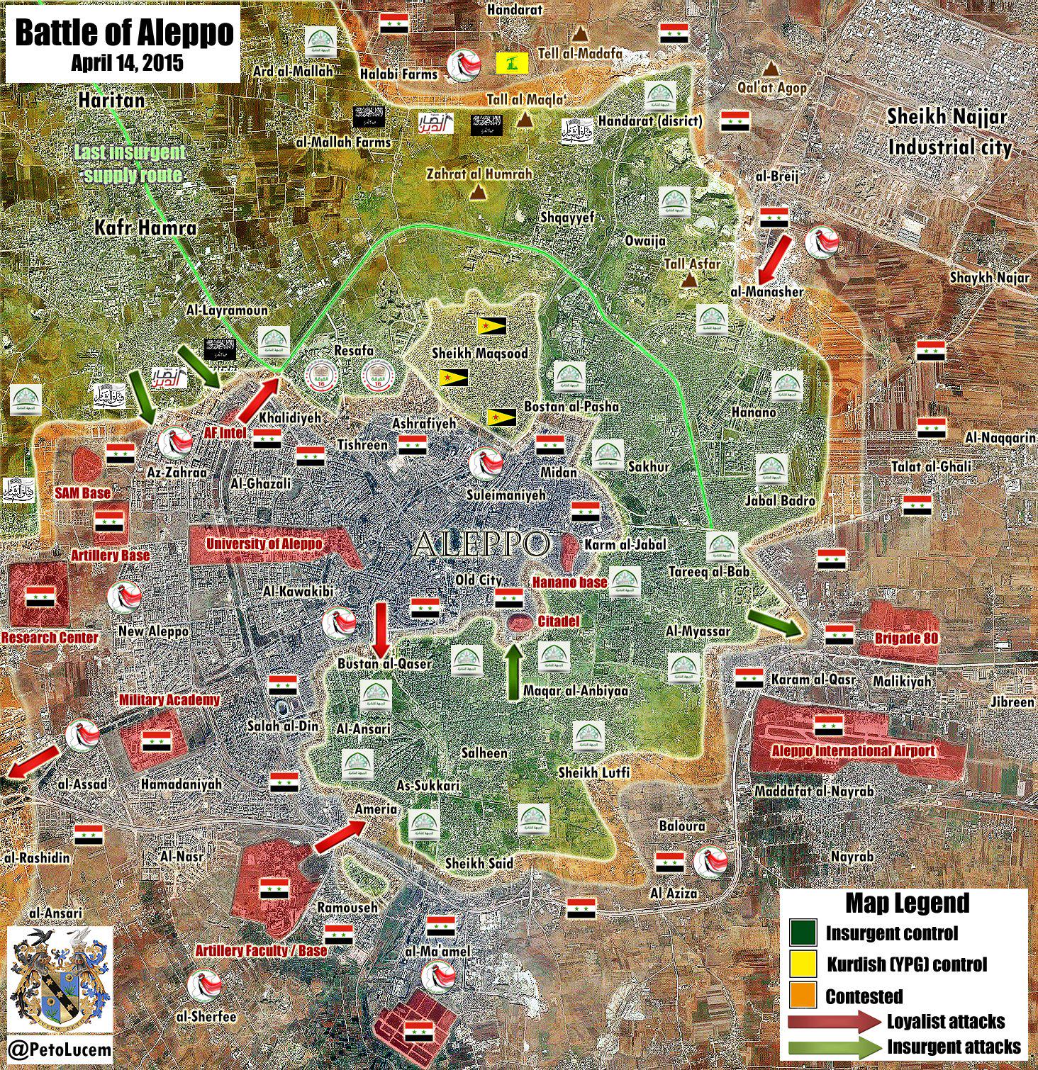
- Syrian troops entered to the town Al Hadher in Southern Aleppo. source
- Here new maps for update here here
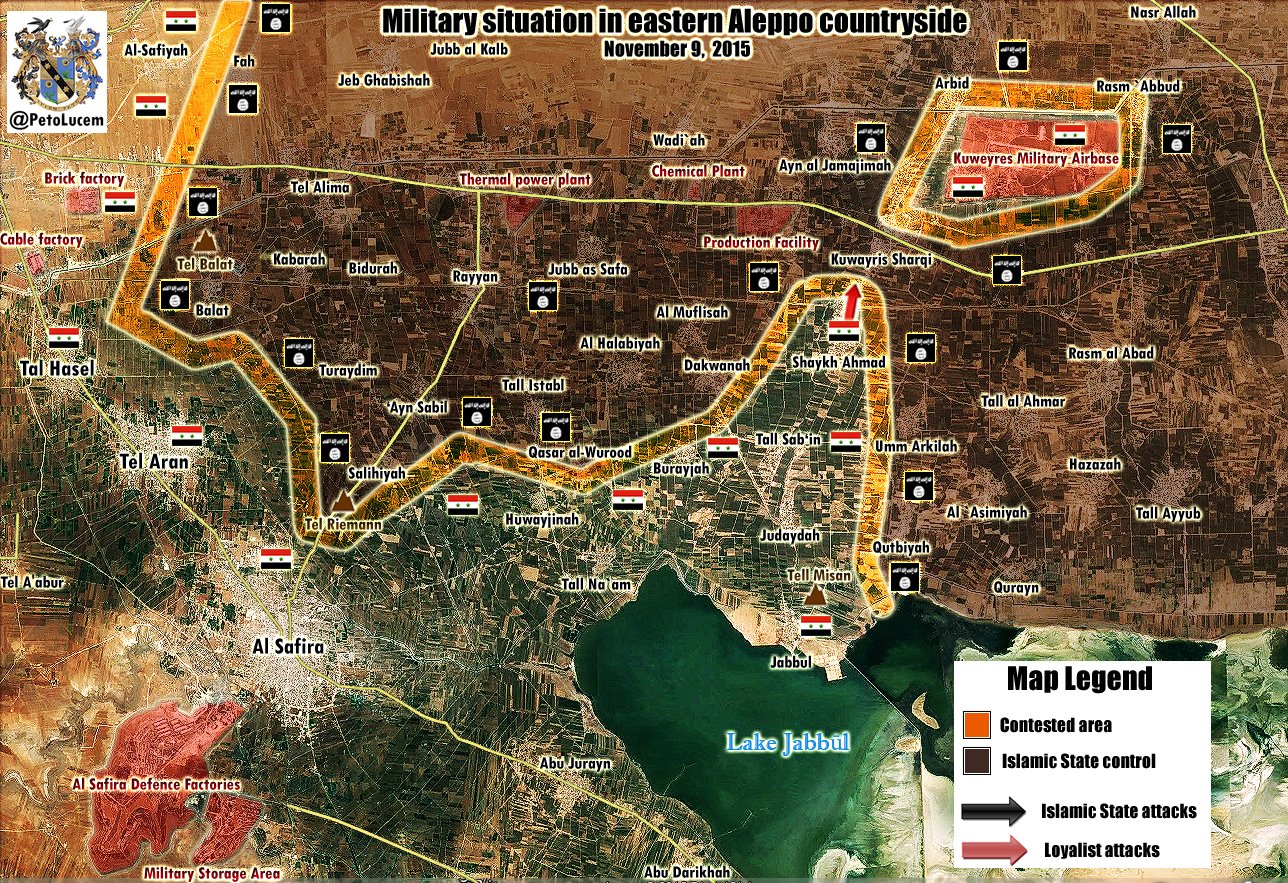
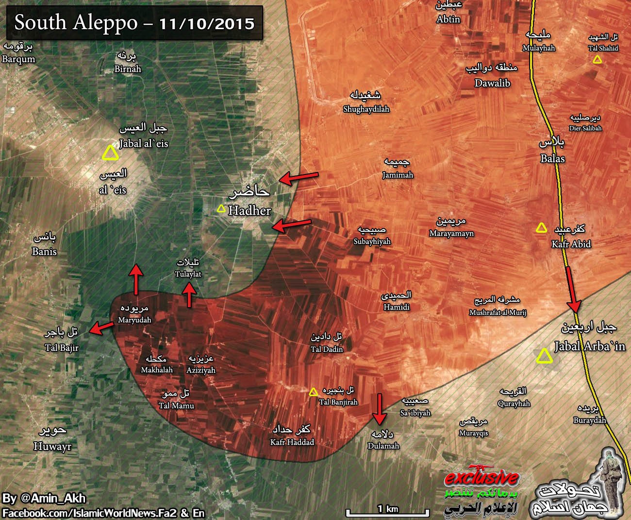
- SAA retake Al Ta'anah from ISIS. source
- SAA retake the villages of Sheikh Ahmad, Kuwayres Sharqi source, Umm Arkilah, Rasm `Abbud source and lifted siege of Kuwayres Air Base.
- SAA retake the villages of Umm Tawous and Kherbet al-Mahal. source 37.52.27.49 ( talk) 08:27, 11 November 2015 (UTC)
Deir ez-Zor clashes
On this map Deir ez-Zor clashes Saqer island need noted as contested. map Albawaba News Hanibal911 ( talk) 06:54, 20 October 2014 (UTC)
- Updated.
MrPenguin20 (
talk) 19:07, 21 October 2014 (UTC)
- Army claim to have retaken the strategic suspension bridge from ISIS in Deir Ez-Zor.
here
Hanibal911 (
talk) 09:40, 25 October 2014 (UTC)
- Sounds like they might have claimed it a bit too soon. I'll keep an eye on it though in case they do complete the encirclement though.
MrPenguin20 (
talk)
- Here new pro government
map Although we do not use pro government sources to display success army but at least may be this map would useful to you.
Hanibal911 (
talk) 08:19, 28 October 2014 (UTC)
- pro oposition source confirmed that Syrian army were in control of most of the Huweijat Saker island, after having seized the bridge linking to IS controlled part city Deir ez-Zor. here Hanibal911 ( talk) 14:31, 9 November 2014 (UTC)
- Here new pro government
map Although we do not use pro government sources to display success army but at least may be this map would useful to you.
Hanibal911 (
talk) 08:19, 28 October 2014 (UTC)
- Sounds like they might have claimed it a bit too soon. I'll keep an eye on it though in case they do complete the encirclement though.
MrPenguin20 (
talk)
- Army claim to have retaken the strategic suspension bridge from ISIS in Deir Ez-Zor.
here
Hanibal911 (
talk) 09:40, 25 October 2014 (UTC)
- Reliable source said that Army during the counter-offensive recovered village Al-Mari’ayyi from IS and regain control of the Deir-ezzour airport perimeter from IS.
Elijah J. Magnier NDF and Syrian troops engaged in fierce attack in Jafra and in Saqr Island.
Elijah J. Magnier Also reliable source said that Syrian army with the support of NDF began counter attack in area of Airport.
here So need do small update on map.
Hanibal911 (
talk) 15:40, 5 December 2014 (UTC)
- Personally I'd trust Magnier, but I thought it was better to wait until it was repeated somewhere else. Have you seen the SAA retaking Mari’ayyi mentioned anywhere else (I haven't yet :S)?
- ISIS took control on the
missiles battalion to northeast of the Airport.
SOHR But later SOHR informed that the IS advances in area the airport stopped after heavy shelling and bombardment by regime forces. Also ISIS pulled back from areas in the mount overlooking Deir ez Zor where located a radar and artillery battery after it was exposed heavy bombardment a regime forces.
SOHR
SOHR
Hanibal911 (
talk) 08:31, 7 December 2014 (UTC)
- Reliable source reported that ISIS retreated after their attack on Deir ez-Zor military airport failed, withdrawing to the outskirts of surrounding villages. The Syrian army launched intensive airstrikes on their strongholds on the outskirts of the villages of al-Jafra, al-Hawija and Marihiyak in order to further secure the airport area and prevent fighters from having a second opportunity at getting close to its walls. Al Monitor Hanibal911 ( talk) 12:18, 10 December 2014 (UTC)
- ISIS took control on the
missiles battalion to northeast of the Airport.
SOHR But later SOHR informed that the IS advances in area the airport stopped after heavy shelling and bombardment by regime forces. Also ISIS pulled back from areas in the mount overlooking Deir ez Zor where located a radar and artillery battery after it was exposed heavy bombardment a regime forces.
SOHR
SOHR
Hanibal911 (
talk) 08:31, 7 December 2014 (UTC)
- Personally I'd trust Magnier, but I thought it was better to wait until it was repeated somewhere else. Have you seen the SAA retaking Mari’ayyi mentioned anywhere else (I haven't yet :S)?
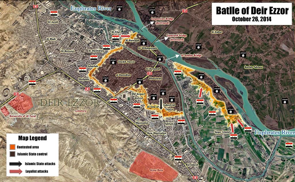
Hanibal,wait a little bit,the Umal Neighborhood must be put as ISIS-Held and with the area leading the mount as contested via EjmAlrai https://twitter.com/EjmAlrai/status/542745203615211520. Alhanuty ( talk) 20:38, 10 December 2014 (UTC)
- Source also said that ISIS advanced before their stopped by Army.
Elijah J. Magnier Also aource said that Syrian army brought reinforcement to the military air base.
Elijah J. Magnier
Hanibal911 (
talk) 20:50, 10 December 2014 (UTC)
- Opposition activists said regime forces regained control of the points on the mountain and Al-Jafra in the vicinity of Deir ez Zour military airport, after clashes with ISIS. The activists stressed that ISIS forced to retreat after a bitter and intensive bombardment Syrian Air Force.
Al Arabiya So ISIS retreated from areas where they had previously occupied some territories and we need noted a village of Al Jafra again under control by army after ISIS retreated.
Hanibal911 (
talk) 22:14, 11 December 2014 (UTC)
- Thanks. Been trying to get a clear picture of what this should look like map-wise. Will upload a new version later tonight.
MrPenguin20 (
talk) 16:06, 13 December 2014 (UTC)
- Just an update so you guys know what happened - as I understand it appears that the situation is largely as it was before the ISIS airport offensive. (In the areas shown in the map anyways). I'll probably take the arrows off the map though because those misleadingly suggest those to be recent SAA gains (thereby suggesting momentum in those areas etc)
MrPenguin20 (
talk) 22:44, 14 December 2014 (UTC)
- ISIS still control village of al- Jafra.
SOHR
Hanibal911 (
talk) 09:50, 9 January 2015 (UTC)
- Thanks! Updated MrPenguin20 ( talk) 13:28, 10 January 2015 (UTC)
- ISIS still control village of al- Jafra.
SOHR
Hanibal911 (
talk) 09:50, 9 January 2015 (UTC)
- Just an update so you guys know what happened - as I understand it appears that the situation is largely as it was before the ISIS airport offensive. (In the areas shown in the map anyways). I'll probably take the arrows off the map though because those misleadingly suggest those to be recent SAA gains (thereby suggesting momentum in those areas etc)
MrPenguin20 (
talk) 22:44, 14 December 2014 (UTC)
- Thanks. Been trying to get a clear picture of what this should look like map-wise. Will upload a new version later tonight.
MrPenguin20 (
talk) 16:06, 13 December 2014 (UTC)
- Opposition activists said regime forces regained control of the points on the mountain and Al-Jafra in the vicinity of Deir ez Zour military airport, after clashes with ISIS. The activists stressed that ISIS forced to retreat after a bitter and intensive bombardment Syrian Air Force.
Al Arabiya So ISIS retreated from areas where they had previously occupied some territories and we need noted a village of Al Jafra again under control by army after ISIS retreated.
Hanibal911 (
talk) 22:14, 11 December 2014 (UTC)
- Could you please check my comments in
[23]? Thank you
Paolowalter (
talk) 07:55, 12 January 2015 (UTC)
- Oh dear I hadn't noticed there was a discussion going on for the file at English wikipedia. Thanks for alerting me - I'll keep an eye on it now, and get to work on the issues raised. MrPenguin20 ( talk) 23:12, 12 January 2015 (UTC)
- Could you please check my comments in
[23]? Thank you
Paolowalter (
talk) 07:55, 12 January 2015 (UTC)
![[23]](/info/en/?search=File_talk:Deir_ez-Zor_clashes_%282011%29.svg#al-_Jnayneh_and_al-_Hsan)
- Clashes took place between regime forces and ISIS in al-Rashedia neighborhood.
SOHR
Hanibal911 (
talk) 12:09, 13 January 2015 (UTC)
- Fixed MrPenguin20 ( talk) 14:43, 16 January 2015 (UTC)
- Violent clashes are taking place between the regime forces and IS militants in the vicinity of Deir Ezzor airbase and in the neighborhood of al- Sena’ah in the city of Deir Ezzor.
SOHR.
Lindi29 (
talk) 22:35, 19 January 2015 (UTC)
- Village of Jaffra under control by Syrian troops. Al Akhbar Hanibal911 ( talk) 16:25, 4 March 2015 (UTC)
Battle of Hasakah
You can correct the map Battle of Hasakah because the IS militants are out of town. And the area west of the city to military base under the control of the army. source Hanibal911 ( talk) 07:38, 22 October 2014 (UTC)
- You can update map according with new source.
here
Hanibal911 (
talk) 08:49, 14 December 2014 (UTC)
- Updated now.
MrPenguin20 (
talk) 22:27, 14 December 2014 (UTC)
- Thank's! Hanibal911 ( talk) 12:13, 15 December 2014 (UTC)
- Updated now.
MrPenguin20 (
talk) 22:27, 14 December 2014 (UTC)
- A small addition on the situation to the west of the city of Hasaka.
here
Hanibal911 (
talk) 12:02, 13 January 2015 (UTC)
- Syrian troops and NDF recapture village Rafrar which is 10KM West of Hasakah. here here Also SOHR reported that violent clashes between IS and the regime forces supported by NDF are still taking place in the west of city al- Hasakah, information reported an advance for the regime forces in the area. SOHR Hanibal911 ( talk) 12:23, 13 January 2015 (UTC)
- You can make small update on the map
Battle of Hasakah because pro opposition source reported that the pro government militias still controlled of village
Al-Dhiyabah which besieged by YPG.
source
Hanibal911 (
talk) 09:55, 2 February 2015 (UTC)
- Updated!
MrPenguin20 (
talk) 02:11, 3 February 2015 (UTC)
- Army expanded the territory which under their control to the east of the city of Hasakah. here Hanibal911 ( talk) 17:07, 13 March 2015 (UTC)
- I keep looking over this map, but I'm not sure if there's any real differences between it and the current version (frontlines seem to be broadly similar, although that map goes further given its larger coverage).
MrPenguin20 (
talk) 15:14, 20 March 2015 (UTC)
- Here is a more detailed map which showed situation around Hasakah.
here Also here another map which confirmed that village of Al Dhiyaba to north from Hasakah still under control by Syrian troops.
here
Hanibal911 (
talk) 15:34, 20 March 2015 (UTC)
- Updated! MrPenguin20 ( talk) 16:18, 20 March 2015 (UTC)
- Here is a more detailed map which showed situation around Hasakah.
here Also here another map which confirmed that village of Al Dhiyaba to north from Hasakah still under control by Syrian troops.
here
Hanibal911 (
talk) 15:34, 20 March 2015 (UTC)
- Updated!
MrPenguin20 (
talk) 02:11, 3 February 2015 (UTC)
- Need update map inside city of Hasakah near of Al Kallasah and Salhiyah neighbourhoods.
here
here
Hanibal911 (
talk) 08:34, 21 March 2015 (UTC)
- You can update the map for city of Hasakah and his countryside. Here map
here also village of Al Dhiyabah still under control by Syrian troops.
source
Hanibal911 (
talk) 20:39, 17 April 2015 (UTC)
- Here new map for update. Please update map.
here also village of Al Dhiyabah still under control by Syrian troops.
source
Hanibal911 (
talk) 21:01, 22 April 2015 (UTC)
- You can update map! Here sources: here Also Syrian army recapture some area near Hasakah which was earlier taken by ISIS. here here Hanibal911 ( talk) 12:43, 5 May 2015 (UTC)
- Pro government source reported that Syrian troops recaptured 8 Villages in Southeast Al-Hasakah(Al-Salihiyah, Al-Hamir, Ward Al-Shaqra, Sakhar, Al-Sarrab, Al-Mujeebrah, Rajman, and Al-Tabah.) here and pro opposition source also reported that Syrian troops seized over 9 villages in the southeastern and eastern countrysides city of Al-Hasakeh. here also after the Syrian troops secured the Mafraq Petrol Factory and Al-Salihiyah, troops and their allies pushed east towards Nariyah, Hamer Al-Sharqiyah, and Gheirha, where they were successful in taking full control of the villages, while cutting off the ISIS militants from the strategic road leading to the town of Al-Houl. here Hanibal911 ( talk) 16:56, 6 May 2015 (UTC)
- Here new map for update. Please update map.
here also village of Al Dhiyabah still under control by Syrian troops.
source
Hanibal911 (
talk) 21:01, 22 April 2015 (UTC)
- You can update the map for city of Hasakah and his countryside. Here map
here also village of Al Dhiyabah still under control by Syrian troops.
source
Hanibal911 (
talk) 20:39, 17 April 2015 (UTC)
- You can update map! Here new sources:
here and village
Al-Dhiyabah also under control by Syrian troops.
here
Hanibal911 (
talk) 21:07, 11 May 2015 (UTC)
- Also please update map for city of Hasakah. Source:
here
here
Hanibal911 (
talk) 16:22, 17 May 2015 (UTC)
- Updated at long last. More to follow.
MrPenguin20 (
talk) 01:39, 18 May 2015 (UTC)
- ISIS lost their positions to west from city of Hasakah.
here
here
Hanibal911 (
talk) 18:21, 22 May 2015 (UTC)
- Updated! MrPenguin20 ( talk) 02:43, 25 May 2015 (UTC)
- ISIS lost their positions to west from city of Hasakah.
here
here
Hanibal911 (
talk) 18:21, 22 May 2015 (UTC)
- Updated at long last. More to follow.
MrPenguin20 (
talk) 01:39, 18 May 2015 (UTC)
- Also please update map for city of Hasakah. Source:
here
here
Hanibal911 (
talk) 16:22, 17 May 2015 (UTC)
- You can update map.
here
Hanibal911 (
talk) 11:50, 30 May 2015 (UTC)
- The interactive map here showed that the Syrian army still control several villages to west from Hasakah. Please update map. 95.134.186.238 ( talk) 15:27, 19 November 2015 (UTC)
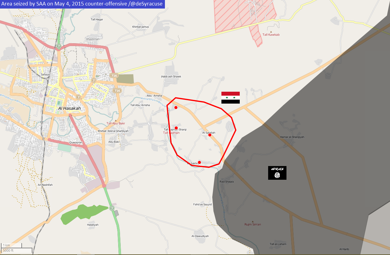
Rif Damashq map
Hey there! You can on this map Rif Damashq map the town of Maliha marked to under army control. This confirmed data from the pro opposition source. Zaman Alwsl Hanibal911 ( talk) 08:34, 12 August 2014 (UTC) According to sources, saa capture tha Maliha. source And this also confirmed SOHR. here and here another source said that army captured the town Al Malihah. source Hanibal911 ( talk) 08:36, 14 August 2014 (UTC)
- Looks like it was just updated today. I edited it though to make sure Maliha was marked. Once again thanks for your help in keeping these updated :).
MrPenguin20 (
talk) 11:17, 16 August 2014 (UTC)
- You can update this map! Because the former the rebel positions to the east of the city of Al Otaiba now under control of the army this confirmed pro opposition
source. For earlier thanks!
Hanibal911 (
talk) 08:13, 18 August 2014 (UTC)
- Done :)
MrPenguin20 (
talk) 00:20, 19 August 2014 (UTC)
- Correct the bug on the map. Because the rebels do not control the entire city of Adra. Adra al-Balad under control by Syrian troops.
SOHR
Hanibal911 (
talk) 18:14, 19 August 2014 (UTC)
- Working on these updates now
MrPenguin20 (
talk) 01:23, 20 August 2014 (UTC)
- Been trying to get a clearer picture of what's going on. By Adra al-Balad I think they just mean the general Adra country area/district. So essentially it's saying fighting is taking place around Adra somewhere. There's this other post from 10 hours ago that talks about a Syrian Army artillery bombardment on Adra proper, which thereby suggests there's still some kind of opposition presence within the town. I'm thinking probably the best way to deal with it is to mark the general area as contested. MrPenguin20 ( talk) 03:07, 22 August 2014 (UTC)
- Working on these updates now
MrPenguin20 (
talk) 01:23, 20 August 2014 (UTC)
- Correct the bug on the map. Because the rebels do not control the entire city of Adra. Adra al-Balad under control by Syrian troops.
SOHR
Hanibal911 (
talk) 18:14, 19 August 2014 (UTC)
- Done :)
MrPenguin20 (
talk) 00:20, 19 August 2014 (UTC)
- You can update this map! Because the former the rebel positions to the east of the city of Al Otaiba now under control of the army this confirmed pro opposition
source. For earlier thanks!
Hanibal911 (
talk) 08:13, 18 August 2014 (UTC)
- According data from pro opposition map the village
Abbadeh under control by Syrian troops.
source
Hanibal911 (
talk) 14:25, 20 September 2014 (UTC)
- Pro-opposition source confirmed the SAA has captured the Adra industrial zone
here Also here another confirmation from pro opposition source that Adra al-ummaliyah under control by army.
source And here Al Jazeera reported that the Syrian army has taken full control of Adra al-ummaliyah.
Al Jazeera
Hanibal911 (
talk) 10:25, 25 September 2014 (UTC)
- Thanks. Adra al-Ummaliyah is JUST north of the map, so it starts just slightly past where the map ends in Adra. Simultaneously the Industrial city is JUST east of the map. Even if they were on the map though it doesn't look like it would change what the map says - it looks like the opposition presence has been underestimated by the map (and me), whilst the government presence has been overestimated. Essentially the recent advances around Adra seem to have just brought the actual frontlines into line with those depicted on the map.
- Regarding Abbadeh the map kind of looks like it says what the wikicommons one does - that the frontline is close to Abbadeh, with fighting occurring nearby. It does look like in that map though that the town proper is under Govt control. I've been trying to find recent information on the status of Abbadeh but most mentions of it are from many months back.
- Probably the biggest potential update would be in the area in the south-west of the map, which looks like it could have a fairly large opposition presence (the Khan al-Shih-Muqalibah area). I'll try and find some more mention of these towns elsewhere before I update though.
MrPenguin20 (
talk) 01:01, 26 September 2014 (UTC)
- SOHR today reported that the regime army took control over wide areas in Adra al Balad Area after two days of its control over the Labor City of Adra.
source So now the whole town of Adra under army control.
- Also pro opposition source claimed that all rebels retreated from all area of city Adta in E-Ghouta. Archicivilians Hanibal911 ( talk) 12:21, 27 September 2014 (UTC)
- SOHR today reported that the regime army took control over wide areas in Adra al Balad Area after two days of its control over the Labor City of Adra.
source So now the whole town of Adra under army control.
- Pro-opposition source confirmed the SAA has captured the Adra industrial zone
here Also here another confirmation from pro opposition source that Adra al-ummaliyah under control by army.
source And here Al Jazeera reported that the Syrian army has taken full control of Adra al-ummaliyah.
Al Jazeera
Hanibal911 (
talk) 10:25, 25 September 2014 (UTC)
- Pro-opposition source said that the Syrian army retake
Dukhaniyya district.
archicivilians
- Near the town of Khan ash-Shih located the
military base 137th Regiment which now under control by army this also confirmed pro opposition map
here But on the map the area is marked completely under control by rebels so that you can correct this mistake on the map.
Hanibal911 (
talk) 06:58, 28 September 2014 (UTC)
- SOHR also reported that the regime forces recaptured al Dokhaneyyi area located on the outskirts of the capital Damascus and which is adjacent to Wadi Ayn Terma and the city of Jaramana.
source
Hanibal911 (
talk) 09:01, 28 September 2014 (UTC)
- Shall update this now
MrPenguin20 (
talk) 20:59, 28 September 2014 (UTC)
- Kurdish journalist reporting Syrian army has captured Al-Suwan and are fighting for Tal-al-Kurdy as they advance towards Duma. Source. Hanibal911 ( talk) 16:44, 30 September 2014 (UTC)
- Shall update this now
MrPenguin20 (
talk) 20:59, 28 September 2014 (UTC)
- SOHR also reported that the regime forces recaptured al Dokhaneyyi area located on the outskirts of the capital Damascus and which is adjacent to Wadi Ayn Terma and the city of Jaramana.
source
Hanibal911 (
talk) 09:01, 28 September 2014 (UTC)
- Near the town of Khan ash-Shih located the
military base 137th Regiment which now under control by army this also confirmed pro opposition map
here But on the map the area is marked completely under control by rebels so that you can correct this mistake on the map.
Hanibal911 (
talk) 06:58, 28 September 2014 (UTC)
- Syrian army took control over the farmlands of
Hosh Farah near the town of Mid’a in the Eastern Ghota.
SOHR
Hanibal911 (
talk) 12:28, 28 October 2014 (UTC)
- Shall update this tomorrow!
MrPenguin20 (
talk) 01:50, 29 October 2014 (UTC)
- Pro opposition
source confirmed that Government troops seized
Bala farms further East completing Zebdeen encirclement.
Hanibal911 (
talk) 20:58, 8 November 2014 (UTC)
- Thanks! I've updated all these now :) (I think). Sorry for the delay - and thanks for the barnstar! MrPenguin20 ( talk) 14:24, 9 November 2014 (UTC)
- Pro opposition
source confirmed that Government troops seized
Bala farms further East completing Zebdeen encirclement.
Hanibal911 (
talk) 20:58, 8 November 2014 (UTC)
- Shall update this tomorrow!
MrPenguin20 (
talk) 01:50, 29 October 2014 (UTC)
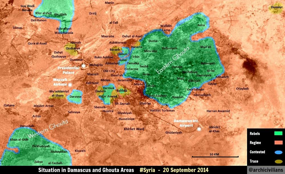
I also have sent you the information to update the map Dara and Deir Ez Zor. Also thank you for your work. Hanibal911 ( talk) 14:35, 9 November 2014 (UTC)
- Yeah I saw those :P - I updated all those too.
MrPenguin20 (
talk) 14:41, 9 November 2014 (UTC)
- Clashes took place between regime forces backed by Hezbollah and NDF against Islamic battalions and Jabhat al-Nusra in Der al-Asafir and Zabdin in eastern Ghouta.
SOHR
Hanibal911 (
talk) 11:20, 10 November 2014 (UTC)
- Shall do this tomorrow!
MrPenguin20 (
talk) 01:46, 12 November 2014 (UTC)
- pro opposition source
Documents.sy reported that army captured town
Zebdeen You can update the map!
Hanibal911 (
talk) 12:52, 22 November 2014 (UTC)
- You can update map! Acoording to pro opposition source
here Syrian army recaptured area to south of Harasta wher located
Army Armored Vehicle Base (Irbeen) in the northern part of the city Irbeen. And recaptured part of Qaboun area. Also
Southern Bypass Highway under control by army.
Hanibal911 (
talk) 11:26, 1 December 2014 (UTC)
- I've changed the Army base to SAA control. I wasn't sure what you meant about the Southern Highway though - isn't it already marked as SAA control? :S MrPenguin20 ( talk) 22:21, 4 December 2014 (UTC)
- You can update map! Acoording to pro opposition source
here Syrian army recaptured area to south of Harasta wher located
Army Armored Vehicle Base (Irbeen) in the northern part of the city Irbeen. And recaptured part of Qaboun area. Also
Southern Bypass Highway under control by army.
Hanibal911 (
talk) 11:26, 1 December 2014 (UTC)
- pro opposition source
Documents.sy reported that army captured town
Zebdeen You can update the map!
Hanibal911 (
talk) 12:52, 22 November 2014 (UTC)
- Shall do this tomorrow!
MrPenguin20 (
talk) 01:46, 12 November 2014 (UTC)
- Clashes took place between regime forces backed by Hezbollah and NDF against Islamic battalions and Jabhat al-Nusra in Der al-Asafir and Zabdin in eastern Ghouta.
SOHR
Hanibal911 (
talk) 11:20, 10 November 2014 (UTC)
- Thank you for your work! Also here then what I said about situation with Southern Bypass Highway.
here
here
here And city
Al Taybeh in the west of Rif Dimashq neem noted as contested.
SOHR
Hanibal911 (
talk) 08:19, 5 December 2014 (UTC)
- Riiight I get it! Thanks - updated now.
MrPenguin20 (
talk) 11:34, 5 December 2014 (UTC)
- SOHR reported that clashes in
Al-Qasimiyah in al- Marej area in the Eastern Ghouta.
SOHR
Hanibal911 (
talk) 20:57, 10 December 2014 (UTC)
- Fixed now.
MrPenguin20 (
talk) 22:39, 14 December 2014 (UTC)
- Thank's! Hanibal911 ( talk) 12:14, 15 December 2014 (UTC)
- Fixed now.
MrPenguin20 (
talk) 22:39, 14 December 2014 (UTC)
- SOHR reported that clashes in
Al-Qasimiyah in al- Marej area in the Eastern Ghouta.
SOHR
Hanibal911 (
talk) 20:57, 10 December 2014 (UTC)
- Riiight I get it! Thanks - updated now.
MrPenguin20 (
talk) 11:34, 5 December 2014 (UTC)
- Pro opposition source confirmed that
Al Wafidin Refugee Camp controlled by army.
Syria Direct
here
Hanibal911 (
talk) 16:57, 17 December 2014 (UTC)
- Updated now. The camp was already under army control on the map - as was a large swathe of territory to the north-east of Douma town. I've since changed that and noted the location of the camp on the map.
MrPenguin20 (
talk) 00:30, 18 December 2014 (UTC)
- You can mark the Madaya in Rif Dimashq as contested.
here
Hanibal911 (
talk) 06:47, 28 January 2015 (UTC)
- Will do! MrPenguin20 ( talk) 01:30, 29 January 2015 (UTC)
- I should have said - assuming you're talking about
this Madaya, it's slightly north-west of the top of the map.
MrPenguin20 (
talk) 10:53, 31 January 2015 (UTC)
- SOHR repoerted that regime forces(Syrian troops) had arrested some people in Khan al- Shih Camp. SOHR And it confirms that Khan al- Shih Camp not entirely under control of the rebels and some parts this camp under control of the army. Hanibal911 ( talk) 09:10, 4 March 2015 (UTC)
- You can mark the Madaya in Rif Dimashq as contested.
here
Hanibal911 (
talk) 06:47, 28 January 2015 (UTC)
- Updated now. The camp was already under army control on the map - as was a large swathe of territory to the north-east of Douma town. I've since changed that and noted the location of the camp on the map.
MrPenguin20 (
talk) 00:30, 18 December 2014 (UTC)
- You can mark as contested the town of
Al-Dirkhabiyah nera Khan ash-Shih because pro opposition source reported that clashes between army and rebels inside this town.
here
Hanibal911 (
talk) 09:49, 29 March 2015 (UTC)
- Updated!
MrPenguin20 (
talk) 14:36, 1 April 2015 (UTC)
- You can make updates on this map. Here new map for update. Also, Syrian Army/NDF captured several building blocks inside city of Darayya in the West Ghoutaafter intense firefights with rebels. Syrian troops captured several building blocks around the following sites: Mahawar Al-Talya, the Darayya National Hospital, the Darayya Association Quarter, Dawar Al-Firin, the Four Seasons Hotel, and on the road to the Darayya Factory. source Also Syrian Army/NDF broke-through the rebels defenses inside the Al-Shayah District of Darayya and imposed full control over the imperative Al-‘Arabiya Neighborhood that sits on the main road to Al-Mo’adhimiyah in rural west Damascus. Syrian Army were able to take control of Al-‘Arabiya Neighborhood in Al-Shayah District after they destroyed main Ajnad Al-Sham HQ building along Darayya-Mo’adhimiyah Road; this powerful assault also led Syrian troops to take control of 50% of this district. source 95.134.223.36 ( talk) 07:52, 8 November 2015 (UTC)
- Updated!
MrPenguin20 (
talk) 14:36, 1 April 2015 (UTC)
- Also update this map. Here new map
here Also SAA/NDF entered in
Marj Al-Sultan Airbase in the East Ghouta and captured
Army base located at the western sector of Deir Salman. source:
here
37.52.25.102 (
talk) 08:14, 12 November 2015 (UTC)
- Update this map. 46.200.38.188 ( talk) 09:17, 14 November 2015 (UTC)
A barnstar for you!

|
The Graphic Designer's Barnstar |
| This prize for your great work by the creation and update the maps. Regards! Hanibal911 ( talk) 19:50, 2 November 2014 (UTC) |
A barnstar for you!
|
|
The Editor's Barnstar |
| Just wanted to say thanks for creating the template (and one of the articles) on elections in the Kingdom of Ireland. This had been on my wishlist for some time. I had asked BrownHairedGirl, but sadly she doesn't seem to be editing much these days. Cheers, Number 5 7 22:28, 18 December 2014 (UTC) |
- Thanks! Yeah I'd been considering making some for a while aswell, but I wasn't sure how best to structure them given the lack of a clear party structure for much of the period (That's also what's making election maps for these elections difficult). I think that just getting the ball rolling and getting good template structures set up with make it easier in future though - at least that's the hope! MrPenguin20 ( talk) 02:14, 20 December 2014 (UTC)
Syria Map editing
Just wanted to find out, is there a way to edit/update and upload a map by myself ? I mean maps that already exist (Alepo, Daraa etc). DuckZz ( talk) 22:08, 6 January 2015 (UTC)
- Sure! I'd suggest using Inkscape. It's free, and allows you to edit SVG files, which most of the maps are (certainly all the ones I upload are). It's pretty simple to use as well, which is always a plus. MrPenguin20 ( talk) 22:10, 6 January 2015 (UTC)
Yeah I don't mean literally "how" because I'm using Photoshop regularly but I'm kinda new to wikipedia, and also an idiot, so i'm not familiar with the usage of files, should i just download the picture and edit it ? How to upload that edited picture on this page ? DuckZz ( talk) 23:47, 6 January 2015 (UTC)
- Yeah just download and edit. On the Wikicommons page for each file there's a list showing the various versions of the file over time, with pictures of those versions next to it. Underneath that there's a link saying "Upload a new version of this file." That'll lead to another link where you can upload the file as you've edited it and explain what changes have been done (There's only so much space though and the edit summary tends to get cut off). MrPenguin20 ( talk) 23:58, 6 January 2015 (UTC)
Oh yes now I see it too lol ... — Preceding unsigned comment added by DuckZz ( talk • contribs) 00:14, 7 January 2015 (UTC)
- Yeah it's pretty easy to miss :P MrPenguin20 ( talk) 00:22, 7 January 2015 (UTC)
Ok I give up, the .svg file is hard to edit, the colors look different when i save the file after editing and some other things come up from nowhere. Also I don't understand why don't you use the geo map from google or wikimapia, and not this street map which looks weird and hard to edit specially for a bigger town like Alepo. This street version looks like a village without much details on the map lol. If you have time you can edit the map instead of me, i'll write what i think should be changed. DuckZz ( talk) 20:40, 7 January 2015 (UTC)
- Yeah sure just tell me what you want changed. Yeah I know it sucks that the maps lack any terrain detail (it's certainly held me back from making other maps that essentially need topography to make sense). The reason they don't is that I've had a hard time finding good quality open source topographic maps - e.g. I think Google maps isn't open source. Wikimapia is, but only the markings that they've added - the satellite imagery is Google's. MrPenguin20 ( talk) 19:41, 8 January 2015 (UTC)
Add these locations which are important because both rebels and government have captured these areas several times.
SOHR and other chanels both neutral and pro-opposition reported that rebels advances in areas of Al Breji and Majbal towards Sheik Najar. Now i wont post rebel sources because there are to many of them, but SOHR could do. SOHR1, SOHR2, This channel shows the timeline of the areas that have been captured, for example This is a pro-rebel map, a good indication but as it's anti-regime, the front lines should be moved to the south a bit. DuckZz ( talk) 20:54, 8 January 2015 (UTC)
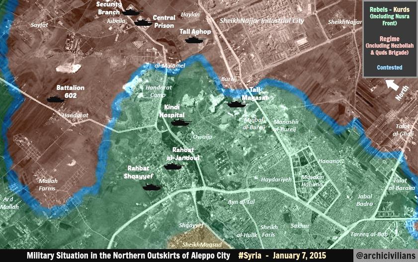
- Here is another pro opposition map which showed to more detaled a situation in this area. deSyracuse for 8 January Hanibal911 ( talk) 21:45, 8 January 2015 (UTC)
- Working on it!
MrPenguin20 (
talk) 14:03, 9 January 2015 (UTC)
- Updated. Essentially went with a version closer to Syracuse than archicivilians, as I felt the latter was maybe a bit overoptimistic. Kind of midway point though MrPenguin20 ( talk) 01:43, 10 January 2015 (UTC)
Orphaned non-free image File:Photograph of Colin Thornton-Kemsley.jpg

Thanks for uploading File:Photograph of Colin Thornton-Kemsley.jpg. The image description page currently specifies that the image is non-free and may only be used on Wikipedia under a claim of fair use. However, the image is currently not used in any articles on Wikipedia. If the image was previously in an article, please go to the article and see why it was removed. You may add it back if you think that that will be useful. However, please note that images for which a replacement could be created are not acceptable for use on Wikipedia (see our policy for non-free media).
Note that any non-free images not used in any articles will be deleted after seven days, as described in the criteria for speedy deletion. Thank you. Stefan2 ( talk) 21:37, 7 January 2015 (UTC)
A barnstar for you!
|
|
The Graphic Designer's Barnstar |
| For your excellent work on improving our maps! Hanibal911 ( talk) 07:55, 10 January 2015 (UTC) |
- Many thanks :) MrPenguin20 ( talk) 13:25, 10 January 2015 (UTC)
Aleppo map
I see in your recent update of the Aleppo battle map you marked Aghob hill to have reverted back to rebel control, however no sources surfaced recently confirming this. Last report about the hill from late December was that the Army captured it. This issue was also raised by editor Pyphon at the map's talk page. If there are no sources saying the rebels captured it I would please ask that you revert it back to SAA-held. Thank you! EkoGraf ( talk) 22:53, 15 January 2015 (UTC)
- Fixed! MrPenguin20 ( talk) 14:43, 16 January 2015 (UTC)
MrPenguin20 I have a question. After I open any .svg file map I get something that i don't expect to see. It's obvious that i'm new to this kind of things, so i don't know if it should look like this or is there some bad option that should be unchecked in my program.
For example the map of Hasaka, it doesn't look editable lol. DuckZz ( talk) 22:40, 18 January 2015 (UTC)
- Oh man, that doesn't look good :S. Maybe it's the program you're using? Can photoshop edit svg's? MrPenguin20 ( talk) 22:58, 18 January 2015 (UTC)
Photoshop can't edit .svg files. I'm using Adobe Illustrator, probably the best program for creating svg files so i don't think the program can't handle it but there must be some other thing that i don't see, maybe something to uncheck in the options ? DuckZz ( talk) 23:23, 18 January 2015 (UTC)
1886 Irish election
On United Kingdom general election, 1886 (Ireland), what do Conservative on a Unionist ticket, Conservative on a Liberal Unionist ticket, and Conservative on a Conservative ticket mean? There were Conservative and Liberal Unionist MPs. The Liberal Unionists were ex-Liberals so "Conservative on a Liberal Unionist ticket" is unfair, but the other two are confusing. 91.213.110.4 ( talk) 17:34, 18 January 2015 (UTC)
- Good point - I'll clear it up. By Conservative on a Unionist ticket I meant Conservative candidates running with support from the
Irish Loyal and Patriotic Union (which then kind of transformed into the Unionist Alliance). Conservative on a Conservative ticket just meant a Conservative running as a Conservative, as opposed to the previously mentioned Conservatives who ran on a kind of Unionist unity platform. I'll tidy it up to make it clearer.
MrPenguin20 (
talk) 21:00, 18 January 2015 (UTC)
- On reflection, it seems the IPLU only ran in the southern counties. In Ulster the situation was different, but it just appears that beginning in 1886 conservatives began running (according to B.M. Walker) as Unionists, rather than really as Conservatives, although the two terms were used interchangeably. I'm going to change the map so as to show all the seats as Conservative, as opposed to Unionist, and then we can just start using Unionist from 1891 with the establishment of the IUA. MrPenguin20 ( talk) 21:15, 18 January 2015 (UTC)
Battle of Hasakah map
Hi, just wanted to make a request for an edit from you on the Hasakah battle map. A couple of days ago, the SAA advanced southeast of Hasakah city and captured two villages, confirmed by SOHR [24]. Masdar and Ivan Sidorenko [25] [26] put the number at 5 and named them as Abu Sa’ad Farms, Khashafaat, Dawaariyeh, Al-Masoul and Rad Shaqraa. I think you should at least mark the two villages closest to the fronltine as government-held now. Thanks! EkoGraf ( talk) 00:49, 6 February 2015 (UTC)
- Original report from SOHR said that Syrian troops after clashes against ISIS take control at least two villages.
SOHR So that SOHR report confirms those reports
here
here which reported that Syrian troops recaptured Abu Sa’ad Farms, Khashafaat, Dawaariyeh, Al-Masoul and Rad Shaqraa.
Hanibal911 (
talk) 20:38, 6 February 2015 (UTC)
- Here the village of
Rad Shaqraa also pro opposition source reported that the Syrian troops recaptured villages of Bab al-Khair and
Sabaa Skor
Hanibal911 (
talk) 21:26, 6 February 2015 (UTC)
- Thanks guys. Had a hard time finding these villages (marked down a lot of other villages in the mean time though), so the current version is kind of a best guess at parts. I'm wondering if Dawaariyeh is supposed to be Dawudiyah, given that many Arabic words don't have clear english translations.
MrPenguin20 (
talk) 14:32, 7 February 2015 (UTC)
- You can update map south of Hasakah.
here
Hanibal911 (
talk) 16:36, 9 February 2015 (UTC)
- You need to fix map because the village Tall Tunainir under control by Syrian troops. See map
Syrian Civil War detailed map And you need to swap places on the map these villages. Because on your map they are set incorrectly. Where on your map you have specified a village of Tall Tunaynir on this place located
Sab‘ Shakur but where on map you have specified a village of Sab‘ Shakur on this place located
Tall Tunaynir. So please correct this mistake on map.
Hanibal911 (
talk) 20:13, 27 February 2015 (UTC)
- I've fixed the labelling of Tall Qa‘bah (thanks). I think Tall Tunaynīr is in the right place though - Sab' Sakur is on the river, and then Tall Tunaynīr is west of it. MrPenguin20 ( talk) 10:50, 23 June 2015 (UTC)
- You need to fix map because the village Tall Tunainir under control by Syrian troops. See map
Syrian Civil War detailed map And you need to swap places on the map these villages. Because on your map they are set incorrectly. Where on your map you have specified a village of Tall Tunaynir on this place located
Sab‘ Shakur but where on map you have specified a village of Sab‘ Shakur on this place located
Tall Tunaynir. So please correct this mistake on map.
Hanibal911 (
talk) 20:13, 27 February 2015 (UTC)
- You can update map south of Hasakah.
here
Hanibal911 (
talk) 16:36, 9 February 2015 (UTC)
- Thanks guys. Had a hard time finding these villages (marked down a lot of other villages in the mean time though), so the current version is kind of a best guess at parts. I'm wondering if Dawaariyeh is supposed to be Dawudiyah, given that many Arabic words don't have clear english translations.
MrPenguin20 (
talk) 14:32, 7 February 2015 (UTC)
- Here the village of
Rad Shaqraa also pro opposition source reported that the Syrian troops recaptured villages of Bab al-Khair and
Sabaa Skor
Hanibal911 (
talk) 21:26, 6 February 2015 (UTC)
2015 Southern Syria offensive
Just wanted to ask, when you have the time, if you could do a map for the current ongoing 2015 Southern Syria offensive. You can use this pro-opposition [27] and this pro-government [28] map as references. The only difference seems to be that the pro-opp map says Tayha is still contested, while the pro-gov says it has also been captured, although we have a neutral source here [29] saying the SAA has definitely captured it.Thanks in advance! EkoGraf ( talk) 12:33, 11 February 2015 (UTC)
- On it!
MrPenguin20 (
talk) 01:02, 12 February 2015 (UTC)
- Took a while (mostly in labelling/delineating the frontline), but I've got a WIP version going that I've attached to the page.
MrPenguin20 (
talk) 02:31, 18 February 2015 (UTC)
- Correct your map because the city
Bosra al Sham and village
Dilli now contested. And aslo clashes neat the town
Ghasm Also city Al Hirak contested. See this map
Syrian Civil War detailed map/doc
Hanibal911 (
talk) 07:14, 18 February 2015 (UTC)
- Oh dear, no rest for the wicked! Updated now. I think the detailed map is showing the clashes around Jizah - not Ghasm. Ghasm just seems to be marked with a large font, giving an unclear impression of its location on the detailed map page. MrPenguin20 ( talk) 01:27, 19 February 2015 (UTC)
- According to pro government source here here and pro opposition source here town Kanaker under control by army also around the town a lot of military facilities and no rebels in the town. So fix map. So that fix this mistake on map. Hanibal911 ( talk) 10:31, 19 February 2015 (UTC)
- village
al-Habbariyyah and near hill Tall Sarja to west from Habbariyah under control by army but on your map, it is contested need fix this.
here Also border zone in the eastern part of the Dara province under control by army but not contested so that fix this. Also village Al Tayha in Quneitra under control by army and Masharah contested. See map:
Syrian Civil War detailed map So please correct map.
Hanibal911 (
talk) 08:26, 20 February 2015 (UTC)
- On the previous version of map here the border zone between Syria and Jordan was marked properly. So you can marked again this border area of the same way. Hanibal911 ( talk) 08:36, 20 February 2015 (UTC)
- Correct your map because the city
Bosra al Sham and village
Dilli now contested. And aslo clashes neat the town
Ghasm Also city Al Hirak contested. See this map
Syrian Civil War detailed map/doc
Hanibal911 (
talk) 07:14, 18 February 2015 (UTC)
- Took a while (mostly in labelling/delineating the frontline), but I've got a WIP version going that I've attached to the page.
MrPenguin20 (
talk) 02:31, 18 February 2015 (UTC)
- Also fix and this map.
Hanibal911 (
talk) 12:11, 21 February 2015 (UTC)
- deSyracuse seems to be reporting the border as contested. I imagine what he's trying to do is convey that the southern border in that location is relatively porous, with an overall lack of control, as opposed to there being strong fighting in the area. I figured the best way to convey this was to mark as contested, with the various govt controlled villages along the border having clearer status. But I suppose alternatively could go the route of not marking it as controlled by anyone (except for the villages that is). MrPenguin20 ( talk) 12:19, 21 February 2015 (UTC)
- deSyracuse not correct showed situation in this area. Also earlier, another pro opposition source showed that border zone still controlled of army.
here
Hanibal911 (
talk) 12:52, 21 February 2015 (UTC)
- Towns and villages you can mark on basis of this map.
Syrian Civil War detailed map on this map they are properly marked. But frontier zone to east from Nassib still under the control of the army.
Hanibal911 (
talk) 12:59, 21 February 2015 (UTC)
- Here map which good showed situation in this area. here Hanibal911 ( talk) 13:03, 21 February 2015 (UTC)
- Towns and villages you can mark on basis of this map.
Syrian Civil War detailed map on this map they are properly marked. But frontier zone to east from Nassib still under the control of the army.
Hanibal911 (
talk) 12:59, 21 February 2015 (UTC)
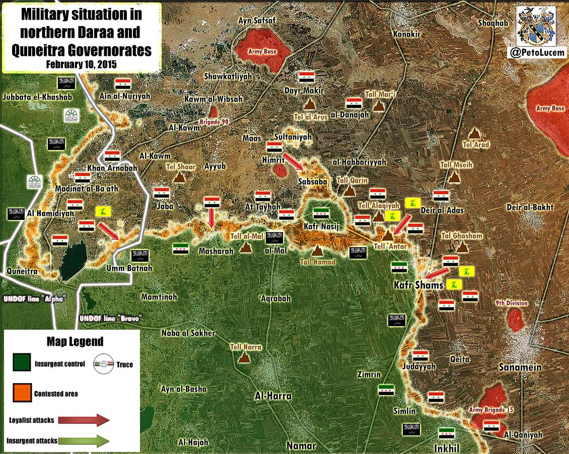
OK, government forces have made new advances in the south so an update for the map is needed. Here are the sources and places captured by the SAA: Sultaniyah, Habariyah, Hamrit and al-Qarin hill (confirmed by pro-opp SOHR) [30], Sabsabah (confirmed by pro-opp Thomas van Linge) [31] and Sultana hill (confirmed by neutral Elijah J.Magnier) [32]. EkoGraf ( talk) 17:26, 28 February 2015 (UTC)
- Updated!
MrPenguin20 (
talk) 19:38, 28 February 2015 (UTC)
- Villages of Al Tayha in Dara and Masharah in Quneitra contested. See map: here and according to data from reliable source village of Simlin contested. Elijah J. Magnier Hanibal911 ( talk) 19:49, 28 February 2015 (UTC)
I noticed that in your last update of the map the names of the hills had become small and are barely readable now. EkoGraf ( talk) 17:39, 1 March 2015 (UTC)
- Yeah I reduced the size of the text in some parts because I was labeling towns and I didn't want the texts to overlap/be unclear. I think I've got a solution in the works though, so I'll increase the font size. MrPenguin20 ( talk) 18:44, 3 March 2015 (UTC)
A barnstar for you!
|
|
The Graphic Designer's Barnstar |
| This award for a good job of creation and timely updating the maps for articles about war in Syria. Good job! Hanibal911 ( talk) 18:10, 19 February 2015 (UTC) |
Disputed non-free use rationale for File:Syriac Union Party (Syria) logo.svg

Thank you for uploading File:Syriac Union Party (Syria) logo.svg. However, there is a concern that the rationale provided for using this file on Wikipedia may not meet the criteria required by Wikipedia:Non-free content. This can be corrected by going to the file description page and adding or clarifying the reason why the file qualifies under this policy. Adding and completing one of the templates available from Wikipedia:Non-free use rationale guideline is an easy way to ensure that your file is in compliance with Wikipedia policy. Please be aware that a non-free use rationale is not the same as an image copyright tag; descriptions for files used under the non-free content policy require both a copyright tag and a non-free use rationale.
_logo.svg)
If it is determined that the file does not qualify under the non-free content policy, it might be deleted by an administrator within a few days in accordance with our criteria for speedy deletion. If you have any questions, please ask them at the media copyright questions page. Thank you. Stefan2 ( talk) 23:52, 19 February 2015 (UTC)
- I originally added it just for the Syriac Union Party page to help identify the Syrian SUP (in contrast to other SUP's), it seems it has since been used on other pages (for which I doubt there's a strong fair use rationale). Would the logo be removed from the original article for which there is a fair use justification too? MrPenguin20 ( talk) 00:00, 20 February 2015 (UTC)
Disambiguation link notification for March 10
Hi. Thank you for your recent edits. Wikipedia appreciates your help. We noticed though that when you edited Progressives (Scotland), you added a link pointing to the disambiguation page Localism ( check to confirm | fix with Dab solver). Such links are almost always unintended, since a disambiguation page is merely a list of "Did you mean..." article titles. Read the FAQ • Join us at the DPL WikiProject.
It's OK to remove this message. Also, to stop receiving these messages, follow these opt-out instructions. Thanks, DPL bot ( talk) 08:56, 10 March 2015 (UTC)
Yemen war detailed map
You can update this map Yemen war detailed map to according data from this map here Hanibal911 ( talk) 11:01, 11 March 2015 (UTC)
- I mostly work with svg's rather than png's, but I'll knock something up. MrPenguin20 ( talk) 23:00, 11 March 2015 (UTC)
A barnstar for you!
|
|
The Graphic Designer's Barnstar |
| Thanks you for updated which you make on our maps which showed details situation in the cities of Aleppo and Hasakah and their surroundings. Cheers! Hanibal911 ( talk) 15:40, 20 March 2015 (UTC) |
- Much obliged :P MrPenguin20 ( talk) 16:17, 20 March 2015 (UTC)
Wales
Hi, thanks a lot for the Sudanese map. Could you help me with a map of Wales I started? Just make the two towns appear on this map, hopefully I will figure out the rest. Cheers.-- Catlemur ( talk) 18:23, 22 March 2015 (UTC)
- No problem. Fixed it now. Was just a small issue. MrPenguin20 ( talk) 18:44, 22 March 2015 (UTC)
Idlib offensive south
You can create a detailed map for the city of Idlib and its environs.As you made for Deir ez Zor and Dara of Hasakah. You can use those map: pro government and pro opposition And place the map on this map Syrian Civil War detailed map as it has done for the Damascus, Aleppo or as for some other cities. Hanibal911 ( talk) 09:15, 27 March 2015 (UTC)
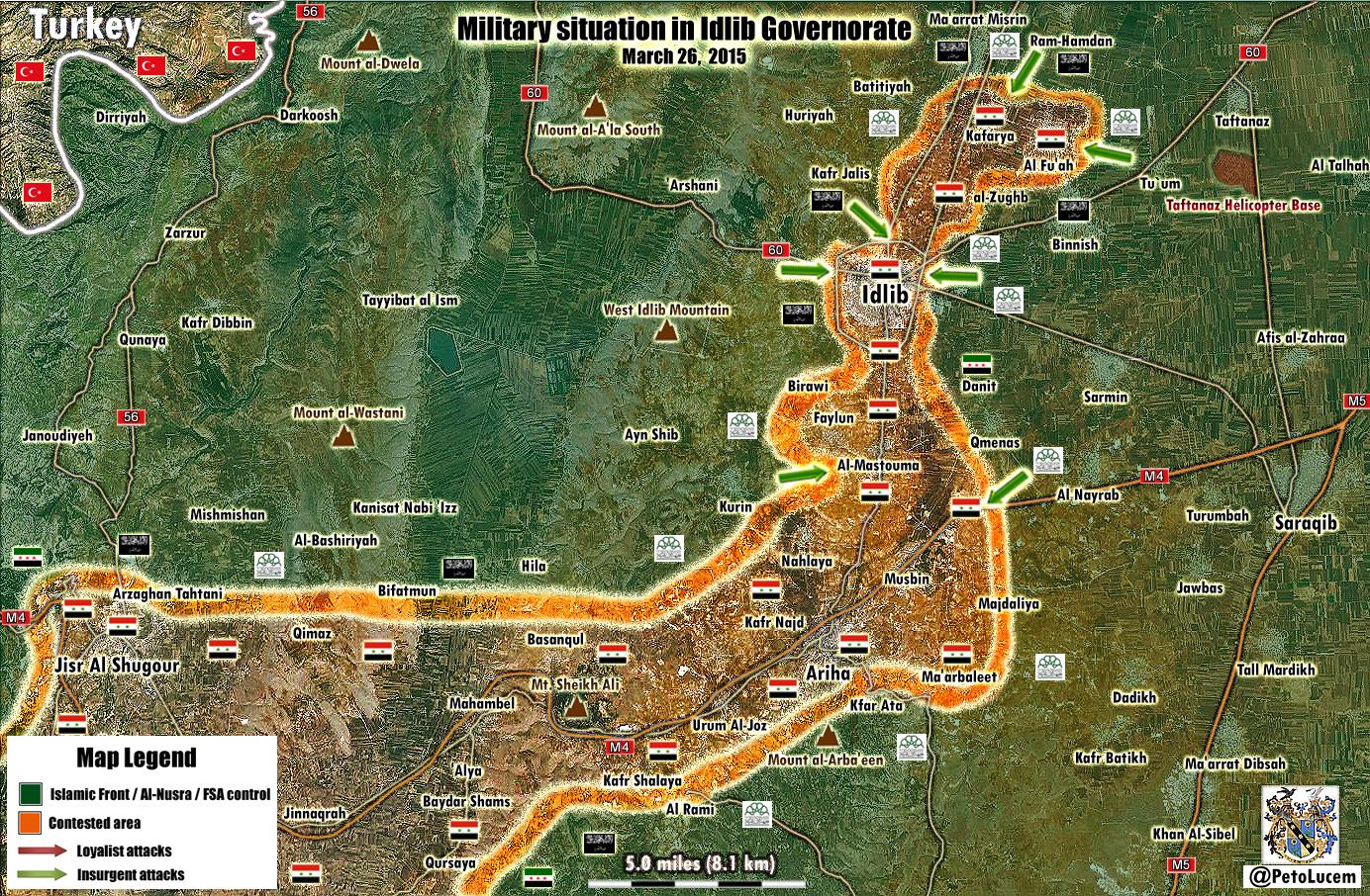
- Also here map from another pro opposition source
Conflict Reporter
Hanibal911 (
talk) 14:00, 27 March 2015 (UTC)
- Seems the only sore point is pro-government sources say the link to government-held towns to the north has not been cut, while rebel sources say it has.
EkoGraf (
talk) 14:44, 27 March 2015 (UTC)
- Looks like the offensive's pretty much over, but I'm still working on a map to show the progression of the offensive. Thanks for the links. MrPenguin20 ( talk) 14:30, 1 April 2015 (UTC)
- Seems the only sore point is pro-government sources say the link to government-held towns to the north has not been cut, while rebel sources say it has.
EkoGraf (
talk) 14:44, 27 March 2015 (UTC)
Rif Dimashq map
Seems ISIS has taken over most of the Yarmouk camp [33]. You could mark it with dark/black color as ISIS-held, or at least the parts confirmed in the source. EkoGraf ( talk) 15:26, 1 April 2015 (UTC)
OK, one more source [34] confirming they control most of the camp. And per that source and this one [35] they also seem to have a presence (are based) in the Hajar Aswad district. Although that area has been under a ceasefire agreement for a long time and even now there are no reports of fighting in it. EkoGraf ( talk) 16:10, 1 April 2015 (UTC)
Ok, this source [36] says Hajar Aswad is definitely rebel-held, so the ISIS forces that came from it into Yarmouk must have been in hiding there, so no changes needed for Hajar Aswad. As for Yarmouk, this source also confirms most of the camp was taken by ISIS but that a Hamas-loyal group retook some of the areas. EkoGraf ( talk) 19:44, 1 April 2015 (UTC)
- Thanks for the update. Seems quite fluid. BBC (I think) was earlier reporting that they're mostly concentrated in south and south-west Yarmouk, so I've updated the map to show that (plus shown some control of northern Hajar Aswad area on border with Yarmouk), but hopefully the extent of control will become clear soon.
MrPenguin20 (
talk) 01:43, 2 April 2015 (UTC)
- Yeah, now that I look at it today, seems the situation is really fluid.
EkoGraf (
talk) 16:24, 2 April 2015 (UTC)
- According to this report
[37] ISIS is now in control of half the district and according to this one
[38] 70 percent.
EkoGraf (
talk) 17:57, 3 April 2015 (UTC)
- One more source for 70 percent
[39] and specifically al-Reiji Square. If they stay in control their territory should be marked as dark to separate them from SAA, rebel and ceasefire territories.
EkoGraf (
talk) 19:00, 3 April 2015 (UTC)
- Thanks. I've updated it a bit more now - most importantly I darkened the shade being used for ISIS so its a lot clearer now (the previous shade, which is used in the other maps, was too similar to the colours around it, especially given it was a relatively small area controlled by ISIS). MrPenguin20 ( talk) 01:14, 4 April 2015 (UTC)
- One more source for 70 percent
[39] and specifically al-Reiji Square. If they stay in control their territory should be marked as dark to separate them from SAA, rebel and ceasefire territories.
EkoGraf (
talk) 19:00, 3 April 2015 (UTC)
- According to this report
[37] ISIS is now in control of half the district and according to this one
[38] 70 percent.
EkoGraf (
talk) 17:57, 3 April 2015 (UTC)
- Yeah, now that I look at it today, seems the situation is really fluid.
EkoGraf (
talk) 16:24, 2 April 2015 (UTC)
- Jabhat al-Nusra and IS take control on 90% of the Yarmouk camp. SOHR Hanibal911 ( talk) 12:05, 4 April 2015 (UTC)
Ok per this map [40], from the pro-opposition Syrian Rebellion Observatory, ISIS has taken over Hajar al-Aswad in the previous months and shows the extent of their control in Yarmouk, as well as the northern corner of the camp being contested after the SAA launched an assault. EkoGraf ( talk) 17:42, 5 April 2015 (UTC)
![[40]](https://pbs.twimg.com/media/CBwa_VeWMAA6GLG.jpg)
- This source
here too biased. Here map from the the less biased the pro opposition source.
Conflict Reported Also SOHR said that the Hajar al- Aswad this ISIS stronghold.
SOHR
Hanibal911 (
talk) 19:41, 5 April 2015 (UTC)
- Syrian troops remain outside the camp and had set up additional checkpoints around Yarmouk after the fighting began.
The Daily Star
Hanibal911 (
talk) 19:52, 5 April 2015 (UTC)
- Not seeing how its biased if its a pro-rebel source that acknowledges a rebel loss of almost two city districts.
EkoGraf (
talk) 21:53, 5 April 2015 (UTC)
- This source here showed that rebels controlled of Tadamon, Beit Sahem, Yalda but this the pro opposition source here showed that Bit Sahem under controll by army and that in Yalda truce as in Qadam and Tadamon contested. Hanibal911 ( talk) 08:25, 6 April 2015 (UTC)
- ISIS pulling out of Yarmouk and Falastine streets inside the camp. Following battles.
source
Hanibal911 (
talk) 17:45, 11 April 2015 (UTC)
- Jaish al-Islam defeat ISIS in Al-Zein street in Yarmouk Camp and take full control of it after fierce battle.
Elijah J. Magnier
Hanibal911 (
talk) 13:17, 12 April 2015 (UTC)
- Thanks for the updates guys. Not got access to my computer (with the program I need) atm, but I'll update these as soon as I can. MrPenguin20 ( talk) 13:48, 14 April 2015 (UTC)
- Jaish al-Islam defeat ISIS in Al-Zein street in Yarmouk Camp and take full control of it after fierce battle.
Elijah J. Magnier
Hanibal911 (
talk) 13:17, 12 April 2015 (UTC)
- Not seeing how its biased if its a pro-rebel source that acknowledges a rebel loss of almost two city districts.
EkoGraf (
talk) 21:53, 5 April 2015 (UTC)
- Syrian troops remain outside the camp and had set up additional checkpoints around Yarmouk after the fighting began.
The Daily Star
Hanibal911 (
talk) 19:52, 5 April 2015 (UTC)
- ISIS fighters have largely withdrawn from a Palestinian refugee camp on the outskirts of Damascus after expelling their main rival. The pull-out ISIS from Yarmouk leaves Al Nusra as the main group inside the camp. ISIS had returned to their stronghold in neighboring Hajar al Aswad, from where they had launched their attack. The Palestine Liberation Organization envoy to Damascus said that Nusra was now the main group in the camp. They and Nusra are one. They are changing of positions.
The Daily Star
Hanibal911 (
talk) 18:19, 15 April 2015 (UTC)
- SOHR reported that ISIS still controlled 80% of the Yarmouk camp the remaining 20% controlled by Islamic groups and Palestinian factions loyal to the Syrian government and clashes still continuing.
SOHR
Hanibal911 (
talk) 19:00, 16 April 2015 (UTC)
- You can update map of Rif Dimashq. Data for update in this discussion.
here
Hanibal911 (
talk) 19:27, 24 April 2015 (UTC)
- Syrian troops captured town of Maydaa in East Ghouta. Al Masdar YnetNews Hanibal911 ( talk) 12:50, 3 May 2015 (UTC)
- You can update map of Rif Dimashq. Data for update in this discussion.
here
Hanibal911 (
talk) 19:27, 24 April 2015 (UTC)
- SOHR reported that ISIS still controlled 80% of the Yarmouk camp the remaining 20% controlled by Islamic groups and Palestinian factions loyal to the Syrian government and clashes still continuing.
SOHR
Hanibal911 (
talk) 19:00, 16 April 2015 (UTC)
- Rebels recaptured Maydaa. here here Hanibal911 ( talk) 08:16, 6 May 2015 (UTC)
License tagging for File:Logo Solidarity Party of Afghanistan.jpg
Thanks for uploading File:Logo Solidarity Party of Afghanistan.jpg. You don't seem to have indicated the license status of the image. Wikipedia uses a set of image copyright tags to indicate this information.
To add a tag to the image, select the appropriate tag from this list, click on this link, then click "Edit this page" and add the tag to the image's description. If there doesn't seem to be a suitable tag, the image is probably not appropriate for use on Wikipedia. For help in choosing the correct tag, or for any other questions, leave a message on Wikipedia:Media copyright questions. Thank you for your cooperation. -- ImageTaggingBot ( talk) 15:05, 2 April 2015 (UTC)
File:Bahr Idriss Abu Garda at ICC.jpg listed for deletion
A file that you uploaded or altered, File:Bahr Idriss Abu Garda at ICC.jpg, has been listed at Wikipedia:Files for deletion. Please see the discussion to see why it has been listed (you may have to search for the title of the image to find its entry). Feel free to add your opinion on the matter below the nomination. Thank you. kelapstick( bainuu) 15:34, 3 April 2015 (UTC)
Egyptian army slogans
Is it possible to help me in the Egyptian army slogans?.-- RabeaMallah ( talk) 04:00, 4 April 2015 (UTC)
- Sure whats the problem?
MrPenguin20 (
talk) 10:12, 4 April 2015 (UTC)
-
This is the slogan of the Egyptian armed forces, but not clear.--
RabeaMallah (
talk) 17:47, 4 April 2015 (UTC)
- Across the top of the shield? It's just a stylistic writing of القوات المسلحة المصرية - Egyptian Armed Forces. Or do you mean how it looks like there might be type across the anchor? (No idea what that says though - type is far too small)
MrPenguin20 (
talk) 21:35, 4 April 2015 (UTC)
- This is the official logo of the Egyptian armed forces, The logo itself, but better and not italic.-- RabeaMallah ( talk) 05:56, 5 April 2015 (UTC)
- Across the top of the shield? It's just a stylistic writing of القوات المسلحة المصرية - Egyptian Armed Forces. Or do you mean how it looks like there might be type across the anchor? (No idea what that says though - type is far too small)
MrPenguin20 (
talk) 21:35, 4 April 2015 (UTC)
-
This is the slogan of the Egyptian armed forces, but not clear.--
RabeaMallah (
talk) 17:47, 4 April 2015 (UTC)
File:Cropped Abdel Rahim Mohammed Hussein.jpg listed for deletion
A file that you uploaded or altered, File:Cropped Abdel Rahim Mohammed Hussein.jpg, has been listed at Wikipedia:Files for deletion. Please see the discussion to see why it has been listed (you may have to search for the title of the image to find its entry). Feel free to add your opinion on the matter below the nomination. Thank you. kelapstick( bainuu) 11:43, 4 April 2015 (UTC)
File:Cropped Haroun speaks with Menkerios.jpg listed for deletion
A file that you uploaded or altered, File:Cropped Haroun speaks with Menkerios.jpg, has been listed at Wikipedia:Files for deletion. Please see the discussion to see why it has been listed (you may have to search for the title of the image to find its entry). Feel free to add your opinion on the matter below the nomination. Thank you. kelapstick( bainuu) 11:44, 4 April 2015 (UTC)
Speedy deletion nomination of Moderates (Scotland)

If this is the first article that you have created, you may want to read the guide to writing your first article.
You may want to consider using the Article Wizard to help you create articles.
Hello, and welcome to Wikipedia. This is a notice that the page you created was tagged as a test page under section G2 of the criteria for speedy deletion and has been or soon may be deleted. Please use the sandbox for any other tests you want to do. Take a look at the welcome page if you would like to learn more about contributing to our encyclopedia.
If you think this page should not be deleted for this reason, you may contest the nomination by visiting the page and clicking the button labelled "Click here to contest this speedy deletion". This will give you the opportunity to explain why you believe the page should not be deleted. However, be aware that once a page is tagged for speedy deletion, it may be removed without delay. Please do not remove the speedy deletion tag from the page yourself, but do not hesitate to add information in line with Wikipedia's policies and guidelines. If the page is deleted, and you wish to retrieve the deleted material for future reference or improvement, then please contact the deleting administrator, or if you have already done so, you can place a request here. Zeke Essiestudy ( talk) 00:51, 5 April 2015 (UTC)
Orphaned non-free image File:Kurdistan Democratic Party of Syria.jpg
Thanks for uploading File:Kurdistan Democratic Party of Syria.jpg. The image description page currently specifies that the image is non-free and may only be used on Wikipedia under a claim of fair use. However, the image is currently not used in any articles on Wikipedia. If the image was previously in an article, please go to the article and see why it was removed. You may add it back if you think that that will be useful. However, please note that images for which a replacement could be created are not acceptable for use on Wikipedia (see our policy for non-free media).
Note that any non-free images not used in any articles will be deleted after seven days, as described in the criteria for speedy deletion. Thank you. Stefan2 ( talk) 22:08, 5 April 2015 (UTC)
A page you started (1969 Saudi Arabian coup d'état plot) has been reviewed!
Thanks for creating 1969 Saudi Arabian coup d'état plot, MrPenguin20!
Wikipedia editor Newrunner769 just reviewed your page, and wrote this note for you:
See tags for details on how to improve
To reply, leave a comment on Newrunner769's talk page.
Learn more about page curation.
Ramadi
You can make map for the city of Ramadi the capital of Anbar province which contested between ISIS and Iraqi troops and their allies. Sources in this discussion. here Hanibal911 ( talk) 05:30, 17 April 2015 (UTC)
Qalamoun
Wanted to ask you if you could do a map for the ongoing SAA/Hezbollah offensive in the Qalamoun mountains Qalamoun offensive (May 2015)? These sources could help May 7 [42], May 8 [43], May 9 [44], May 10 [45], May 13 [46]. Thank you! EkoGraf ( talk) 18:44, 13 May 2015 (UTC)
Eastern Ghouta and Deir ez zor
Jaish Al-Islam has regained Maydaa and froced regime forces to withdraw from it via SOHR http://www.syriahr.com/en/2015/05/advances-for-rebels-in-maydaa-town/ Also,Pro-regime source confirmed that Al-Rayhan is rebel-held,with Hawsh Al-Farah contested http://s2.img7.ir/6k64b.jpg.Alhanuty (talk) 15:36, 6 May 2015 (UTC) Also ISIS has recaptured Hawija Saker Island via SOHR http://www.syriahr.com/2015/05/%D8%A3%D9%83%D8%AB%D8%B1-%D9%85%D9%86-34-%D9%82%D8%AA%D9%8A%D9%84%D8%A7%D9%8B-%D9%85%D9%86-%D9%82%D9%88%D8%A7%D8%AA-%D8%A7%D9%84%D9%86%D8%B8%D8%A7%D9%85-%D8%AE%D9%84%D8%A7%D9%84-%D8%B3%D9%8A%D8%B7/. Alhanuty ( talk) 23:28, 15 May 2015 (UTC)
tell me how to do it. Alhanuty ( talk) 01:57, 16 May 2015 (UTC)
- Finally back from my various travels, so I'll get to work updating these. I should get them all done tonight. The files are all svg's, and can be edited using Inkscape, which is free. MrPenguin20 ( talk) 14:39, 17 May 2015 (UTC)
Damascus map?
Are you still planning to fix the Damascus map-- as the top left is purple and bottom left is red. — Preceding unsigned comment added by 169.231.26.212 ( talk) 17:10, 23 May 2015 (UTC)
Aleppo map
Hi. Do you have time to update the map, according to SOHR Rebel captured the entire Rashidin district west of Aleppo. The size of the district can be seen here. They captured everything besides the military research center. This opposition map can be a quide because the same is said on SOHR. DuckZz ( talk) 18:36, 17 June 2015 (UTC)
I think SOHR was referring to the Rashidin suburb only. Although now it says fighting continues in its outskirts. EkoGraf ( talk) 14:45, 21 June 2015 (UTC)
- Reuters seems to be suggesting government forces the Rashidin regained areas taken by opposition forces (I note though that its a govt claim, not an independent one). I've changed the suburb to contested for now, thoughts? MrPenguin20 ( talk) 11:09, 25 June 2015 (UTC)
Hasakah map update
Can you update the western edge of government control in the city's outskirts? Per this map here [47] Umm Dibs, Emero and Mafraq Siddiq are government-held, while our Wikipedia map [48] shows them as Kurdish-held. Thank you! EkoGraf ( talk) 14:43, 21 June 2015 (UTC)
![[48]](/info/en/?search=Cities_and_towns_during_the_Syrian_Civil_War#/media/File:Battle_of_Hasakah.svg)
- Thank you - sorry for the delay, been away on business. Just updated it. MrPenguin20 ( talk) 11:00, 23 June 2015 (UTC)
i have created this map,but i need help in organizing it,can you help me organizing it. Alhanuty ( talk) 20:39, 5 July 2015 (UTC)
- On it! MrPenguin20 ( talk) 15:39, 6 July 2015 (UTC)
Jisr Abyad area is under YPG control
Jisr Abyad is YPG held and being attacked by ISIS via SOHR http://umap.openstreetmap.fr/en/map/twittercizirecanton-tap-the-map-for-information_36481#13/36.3883/40.6434,the Battle of Hasakah map needs to be updated to show this http://umap.openstreetmap.fr/en/map/twittercizirecanton-tap-the-map-for-information_36481#13/36.3883/40.6434. AlAboud83 ( talk) 22:55, 7 July 2015 (UTC)
- Thanks - was looking at this earlier. Updated version will be up later in the day. MrPenguin20 ( talk) 14:59, 8 July 2015 (UTC)
New update of YPG and ISIS held areas in Hasakah city and surroundings http://www.syriahr.com/en/2015/07/ypg-and-al-sanadid-army-advance-towrards-al-ahdath-prison-while-warplanes-strike-al-hasakah-city-and-its-southern-countryside/. Alhanuty ( talk) 16:01, 16 July 2015 (UTC)
1832-1841 General Election maps
Hello
I’ve just come across your 1830 – 1841 General Election maps on here. Let me start by saying they are terribly good and a very welcome contribution. Having done a very inadequate map of 1784 myself I think it’s grand someone could take it and turn it into an excellent hi-res SVG as you have.
So I hope you won’t take it amiss if I say I went through it with a fine tooth comb, because if these things are to be done they should be got as correct as they could. What I’m laying out below, I hope, won’t come over as fernickety and nitpicking but as an aide to really hammer the thing into shape.
Let me also say that if I knew how to use SVG I would make the amendments myself and send you the map first so you could publish it – as it is (as you can see from the 1784 map) Paint is my limit.
Could I ask you to make the amendments and republish, or would it be too much?
- Wick Burghs: The contributory burgh of Cromarty is missing. The list of contributory burghs is here [49]. Maps of the Scottish burghs are here [50].
- Inverness-shire/Elgin & Nairn: The border here is very clean whereas in your 1830 map there are some detached parts. The 1832 Act doesn’t seem to have moved detached parts there, though I may be wrong.
- Aberdeenshire/Kincardineshire: The border here is very wrong. What is now called Royal Deeside has been added to Kincardine.
- Montrose Burghs: Kirriemuir is not a contributory burgh.
- Kirkcaldy Burghs: The contributory burgh of Kinghorn is missing.
- Stirling Burghs: The contributory burgh of Culross is missing.
- Falkirk Burghs: The contributory burghs of Airdrie, Hamilton, Lanark and Linlithgow are missing. Grangemouth is not a contributory burgh.
- Leith Burghs: Leith and Portobello appear to have been merged.
- Haddington Burghs: The whole constituency is missing. The contributory burghs are Haddington, Dunbar, North Berwick, Lauder and Jedburgh.
- Dumfries Burghs: Langholm, Lockerbie and Moffat are not contributory burghs.
- Wigtown Burghs: The whole constituency is missing. The contributory burghs are Wigtown, New Galloway, Stranraer and Whithorn.
- Ayr Burghs: The contributory burgh of Inverary is missing. Irvine and Troon are not contributory burghs.
- Greenock: The constituency is missing.
- Kilmarnock Burghs: The contributory burghs of Port Glasgow and Rutherglen are missing.
- County Durham, Southern Division: It looks like Stockton has been added as a seat, but perhaps it’s just a loop in the Tees.
- East Retford: The constituency is missing. The constituency consisted of the whole of the wapentake of Bassetlaw.
- Much Wenlock: Alveley was not part of the seat.
- Abingdon: The constituency is missing.
- New Shoreham: The constituency is missing. The constituency consisted of the whole of the rape of Bramber.
- Surrey, Western Division: What is the borough to the east of Windsor?
- Surrey, Eastern Division: What is the borough in the area of Richmond?
- Newport (Isle of Wight): The constituency is missing.
- Rye: Is this the right boundary? Not sure.
- Helston: Is this on the right coast? Not sure.
- Pembroke Boroughs: What is the contributory borough to the south west of Pembroke?
- Radnor Boroughs: Presteigne and New Radnor appear to have been merged.
- Caernarvon Boroughs: Penmaenmawr and Colwyn Bay are not contributory boroughs.
None of this is meant as a distraction from your work which is first rate and far beyond my limits. Well done on this.
I’ve put this on your Wikipedia page and Wikicommons page. Marplesmustgo ( talk) 12:47, 1 August 2015 (UTC)
Update Aleppo Map
You need to update the Aleppo Map. The YPG forces in Sheikh Masqoud have made major advances against rebels: Before: http://www.almasdarnews.com/wp-content/uploads/2015/09/Sheikh-Maqsoud-702x336.png After: http://www.almasdarnews.com/wp-content/uploads/2015/09/Sheikh-Maqsoud-702x336.png
Pbfreespace3 ( talk) 21:50, 30 September 2015 (UTC)
- I think you sent the same map twice? MrPenguin20 ( talk) 22:43, 30 September 2015 (UTC)
Here is the after map: https://pbs.twimg.com/media/CP7GocqUcAAHxXe.jpg You need to update this area in the SVG file.
Afghanistan Map
Which map are we going to use for Afghanistan? Is is this one or is it that one? We need to agree on one map for the conflict, not 2. We need to pick one and delete the other.
The one I helped create is more detailed than the other one, and has IS control in Nangarhar and Helmand provinces. I think we should stick to this one. Pbfreespace3 ( talk) 21:55, 30 September 2015 (UTC)
- Works for me. Do you want to mark the other map for deletion or shall I? MrPenguin20 ( talk) 22:09, 30 September 2015 (UTC)
You do it. Thank you for responding so quickly. Pbfreespace3 ( talk) 23:27, 30 September 2015 (UTC)
- I've marked it for deletion. No problem! I'll fix the Aleppo map now. MrPenguin20 ( talk) 23:38, 30 September 2015 (UTC)
Just a query about the map - who is the purple meant to be? It makes me think UKIP, and none of the parties listed in the results table are purple. Cheers, Number 5 7 16:06, 6 October 2015 (UTC)
- I've updated the wikicommons box now! The results marked the winning councillor in the areas marked as purple as a "Borders Independent," as opposed to the other Independent candidates. The 1982 election also saw someone else elected as an Independent Progressive/Progressive Independent, but I've just marked them as an independent for now (considering marking them different, since they seem to have marked themselves as being different).
- I chose purple mainly because the current Borders Regional party - the Borders Party - uses the same colour. Could change it to some kind of darker grey - like I did for the [
Argyll & Bute election] - if you think the purple might be confusing?
MrPenguin20 (
talk) 16:13, 6 October 2015 (UTC)
- The purple is fine, it's just that it doesn't match the colour in the results table for the Border Independent - I guess that's what actually needs fixing?
Number
5
7 20:06, 6 October 2015 (UTC)
- Fixed it! MrPenguin20 ( talk) 10:51, 11 October 2015 (UTC)
- The purple is fine, it's just that it doesn't match the colour in the results table for the Border Independent - I guess that's what actually needs fixing?
Number
5
7 20:06, 6 October 2015 (UTC)
Hama offensive map
First MrPenguin20, I want to thank you on the great map you made. Now, I just wanted to note a correction that needs to be done. In the Latakia region you marked the village of Durin (southwest of Salma) to be rebel-held before the offensive and now contested. That village was captured by the Syrian Army months ago [51] [52]. Cheers! :) EkoGraf ( talk) 00:37, 11 October 2015 (UTC)
- Oh dear. Thanks for that. I think I must have misread the big wiki map (maybe hovered over the wrong town). I'll fix that now. MrPenguin20 ( talk) 10:53, 11 October 2015 (UTC)
Battle of Aleppo map update
New developments. Per SOHR [53] the Syrian Army captured, northeast of Aleppo, the Free Zone (you already marked it), Juvenile prison (in Mahattah [54]) and cement plant (north of Mahattah [55]). This has been confirmed by pro-government Peto Lucem. This would also mean they captured Mahattah itself. EkoGraf ( talk) 03:52, 13 October 2015 (UTC)
- Shall update this today!
MrPenguin20 (
talk) 10:04, 14 October 2015 (UTC)
- Anti government source showed situation to east of Aleppo and south of Kuwairys Air Base.
here Please update map.
Saphyr99 (
talk) 06:18, 17 October 2015 (UTC)
- New map from Anti government source showed situation to east of Aleppo and south of Kuwairys Air Base.
here Please update map.
Saphyr99 (
talk) 05:25, 18 October 2015 (UTC)
- Updated!
MrPenguin20 (
talk) 14:23, 18 October 2015 (UTC)
- Tall Riman and Salihiyah http://wikimapia.org/#lang=en&lat=36.109172&lon=37.406902&z=13&m=b&gz=0;373912811;361136100;121879;113706;149345;98454;149345;70721;101280;38135;51498;7627;20599;0;0;33281;15449;54775;39482;70028;123596;113706&show=/33526929/Tall-R%C4%ABm%C4%81n-%D8%AA%D9%84-%D8%B1%D9%8A%D9%85%D8%A7%D9%86-Tel-Riemann http://www.almasdarnews.com/article/russian-military-takes-command-of-east-aleppo-operations/ http://www.almasdarnews.com/article/russians-lead-the-battle-in-east-aleppo-syrian-army-advances-towards-the-kuweires-military-airport/ these villages was seized SAA in end of September. Saphyr99 ( talk) 15:27, 18 October 2015 (UTC)
- Updated!
MrPenguin20 (
talk) 14:23, 18 October 2015 (UTC)
- New map from Anti government source showed situation to east of Aleppo and south of Kuwairys Air Base.
here Please update map.
Saphyr99 (
talk) 05:25, 18 October 2015 (UTC)
- Anti government source showed situation to east of Aleppo and south of Kuwairys Air Base.
here Please update map.
Saphyr99 (
talk) 06:18, 17 October 2015 (UTC)
- Here new map for update.
https://pbs.twimg.com/media/CRjxaA5WEAAYipB.png:large
https://twitter.com/_paulo34/status/655539176423731200
Saphyr99 (
talk) 19:47, 18 October 2015 (UTC)
- Maps for new update. https://ton.twitter.com/i/ton/data/dm/656520874611384323/656520874636541952/lUyO6jvB.jpg https://pbs.twimg.com/media/CRyGPlqWIAAOivt.jpg:large https://twitter.com/Amin_Akh/status/656532638577111047 Saphyr99 ( talk) 15:43, 21 October 2015 (UTC)
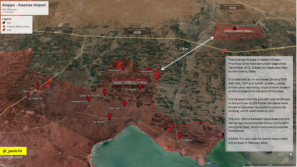
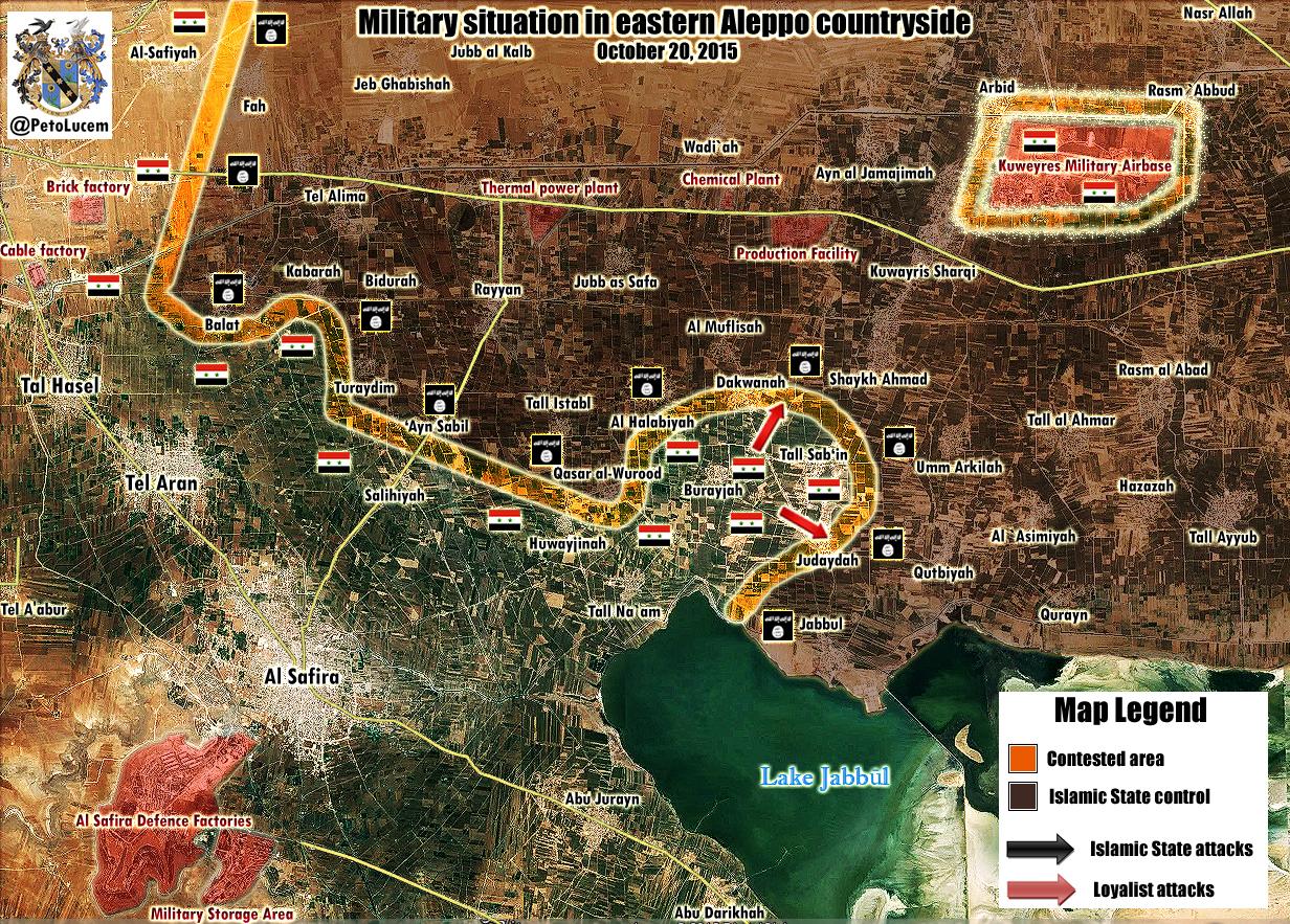
Syrian troop captured Al Halabiyah , Qasar al-Wurood, Dawakanah and entered the strategic town of Shekh-Ahmad(contested between SAA and ISIS) which is situated approximately 2km away from the Kuweires Military Airport. source source source Saphyr99 ( talk) 16:44, 22 October 2015 (UTC)
- Thanks! Updated all these now.
MrPenguin20 (
talk) 10:48, 23 October 2015 (UTC)
- New map for update.
https://pbs.twimg.com/media/CSKq0qGUEAAmmZ7.jpg:large
Saphyr99 (
talk) 14:20, 25 October 2015 (UTC)
-
Al-Salihiyah
Tel Reiman and
Al Halabiyah under ISIS.
http://www.almasdarnews.com/article/battle-for-east-aleppo-intensifies-as-isis-and-the-syrian-army-fight-for-kuweires-airbase/
Saphyr99 (
talk) 05:50, 26 October 2015 (UTC)
- On it! MrPenguin20 ( talk) 10:39, 27 October 2015 (UTC)
-
Al-Salihiyah
Tel Reiman and
Al Halabiyah under ISIS.
http://www.almasdarnews.com/article/battle-for-east-aleppo-intensifies-as-isis-and-the-syrian-army-fight-for-kuweires-airbase/
Saphyr99 (
talk) 05:50, 26 October 2015 (UTC)
- New map for update.
https://pbs.twimg.com/media/CSKq0qGUEAAmmZ7.jpg:large
Saphyr99 (
talk) 14:20, 25 October 2015 (UTC)
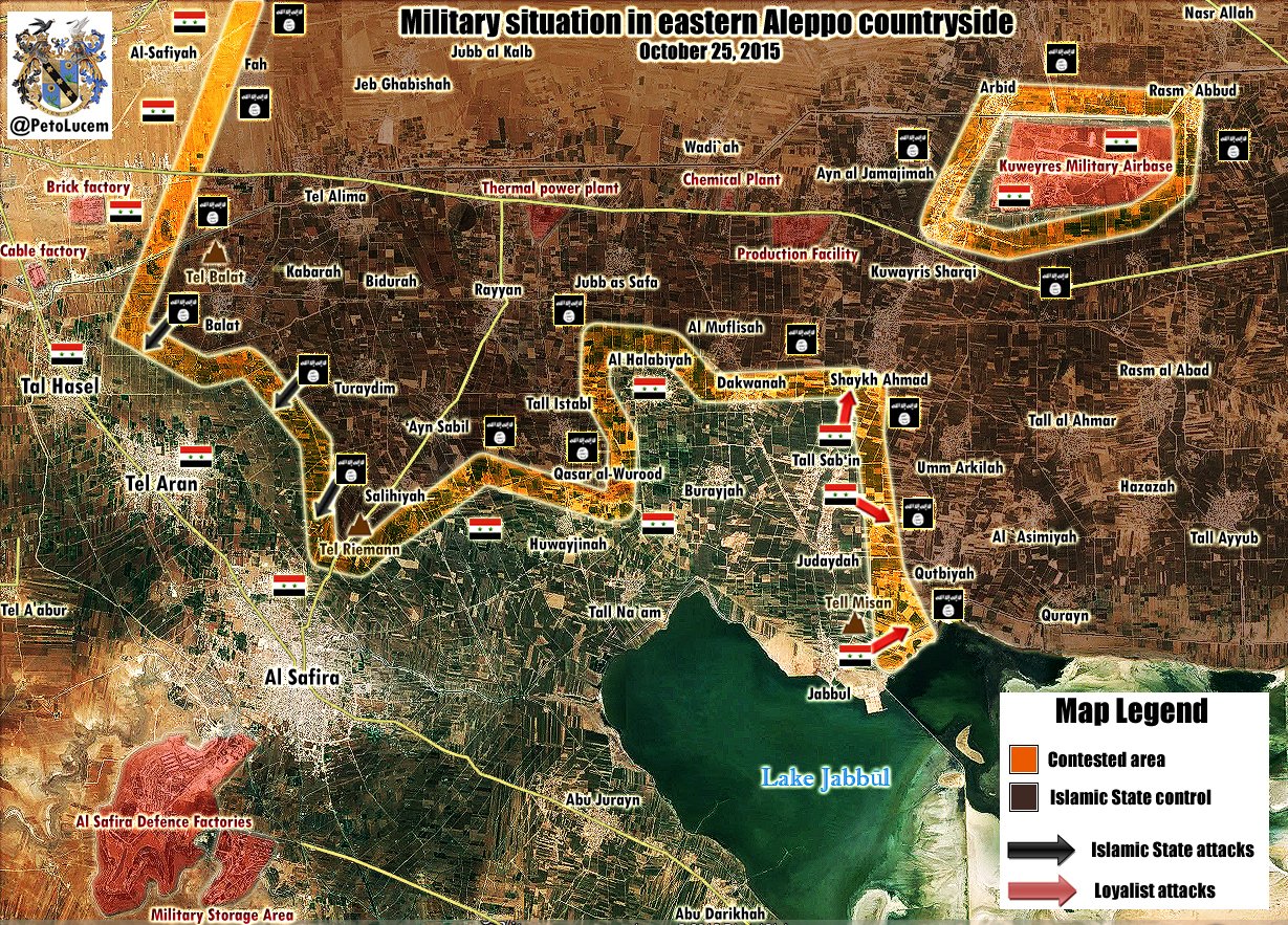
Location map request
Dear MrPenguin. I noticed you have experience in creating location map modules. Can you take a look at my request for such a map at: Wikipedia:Lua/Requests#Requesting Module:Location map/data/Pyongyang? Finnusertop ( talk | guestbook | contribs) 10:48, 17 October 2015 (UTC)
- Done! MrPenguin20 ( talk) 16:01, 18 October 2015 (UTC)

|
The Mapmaker's Barnstar | |
| In lieu of a Module/Lua barnstar, I hereby award MrPenguin20 the Mapmaker's Star for creating the Pyongyang location map. Finnusertop ( talk | guestbook | contribs) 17:45, 18 October 2015 (UTC) |
- Very kind of you! It was really no bother. Thank you MrPenguin20 ( talk) 10:08, 23 October 2015 (UTC)
Possibly unfree File:INC flag.svg
A file that you uploaded or altered, File:INC flag.svg, has been listed at Wikipedia:Possibly unfree files because its copyright status is unclear or disputed. If the file's copyright status cannot be verified, it may be deleted. You may find more information on the file description page. You are welcome to add comments to its entry at the discussion if you object to the listing for any reason. Thank you. Sfan00 IMG ( talk) 17:33, 28 October 2015 (UTC)
Aleppo Offensives 2015.svg
Please update this map https://upload.wikimedia.org/wikipedia/commons/a/a9/Aleppo_Offensives_2015.svg Opposition source confirmed that the city Kafr Abid under control by Syrian troops. http://i2.wp.com/archicivilians.com/wp-content/uploads/2015/10/SouthAleppo.png 95.134.214.182 ( talk) 14:28, 29 October 2015 (UTC)
- On it!
MrPenguin20 (
talk) 13:22, 30 October 2015 (UTC)
- Here new maps for update.
her and
here
37.52.27.160 (
talk) 07:56, 9 November 2015 (UTC)
- Updated! MrPenguin20 ( talk) 18:31, 9 November 2015 (UTC)
- Here new maps for update.
her and
here
37.52.27.160 (
talk) 07:56, 9 November 2015 (UTC)
- Here new data for update the map:
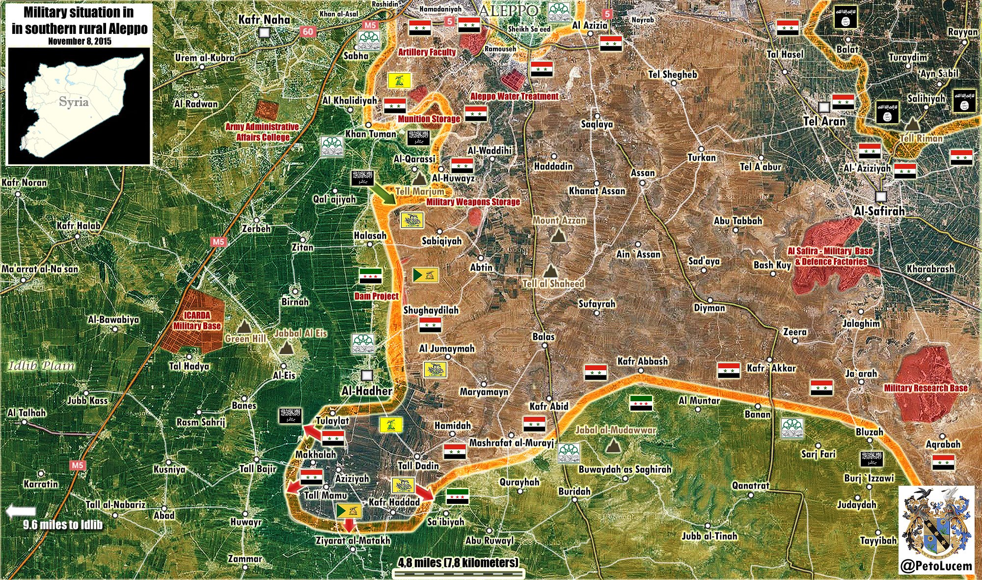
- Syrian troops entered to the town Al Hadher in Southern Aleppo. source
- Here new maps for update here here
- SAA retake Al Ta'anah from ISIS. source
- SAA retake villages of Sheikh Ahmad, Kuwayres Sharqi source, Umm Arkilah, Rasm `Abbud source and lifted siege of Kuwayres Air Base. 37.52.27.49 ( talk) 08:23, 11 November 2015 (UTC)
- Please update this maps
Rif Aleppo2 and
Aleppo Offensives 2015
- Syrian army recaptured from ISIS Umm Arkilah, Rasm Abbud source: here
- Also SAA retake Judaydah Arbin and Arbid source: here here 37.52.25.102 ( talk) 07:53, 12 November 2015 (UTC)
- Syrian army captured town Al Hadher
source and Jabal Arba'in. New map for update.
her
37.52.25.102 (
talk) 14:15, 12 November 2015 (UTC)
- Also Syrian army captured villages Kherbet al-Mahal Tell Bajer source Banes and the nearby village of Rasm Al-Sahreej. source and the town Al-Eis SOHR Also Syrian troops and allies advanced 4.5km along the Aleppo-Raqqa Highway and captured Sysacco Chemical Plant source please update maps. 37.52.28.243 ( talk) 10:31, 13 November 2015 (UTC)
- Thanks! Sorry was a bit busy. I've updated it now. Look's like there's some reports about Government forces taking Tal Hadya right now, but I'll wait until these are confirmed before updating.
MrPenguin20 (
talk) 12:55, 13 November 2015 (UTC)
- New map do update
here
46.200.38.188 (
talk) 20:07, 13 November 2015 (UTC)
- Please also update this map Rif Aleppo2 46.200.38.188 ( talk) 08:59, 14 November 2015 (UTC)
- Also Umm Arkilah and and Arbid under control by Syrian troops. Sources: here here here 46.200.38.188 ( talk) 11:08, 14 November 2015 (UTC)
- New map do update
here
46.200.38.188 (
talk) 20:07, 13 November 2015 (UTC)
- Syrian army captured ICARDA Farms to north of Kuweyres Airbase. SOHR Al Masdar 178.95.150.71 ( talk) 10:10, 15 November 2015 (UTC)
- Syrian army captured village Karkiz and advance to the village of Aqulat Aqulah to which ISIS withdraw after SAA caputed Kirkaz. source SOHR 95.135.205.133 ( talk) 14:10, 16 November 2015 (UTC)
- Syrian army captured village Khalasah source and entered to the village of Humaymah Al-Kabirah and advance south towards Aqulat Aqulah. source 95.134.186.238 ( talk) 18:30, 17 November 2015 (UTC)
- Just edited the map to show these developements. Wikicommons just seems to be a little slow updating the image. Thanks though.
MrPenguin20 (
talk) 18:33, 17 November 2015 (UTC)
-
MrPenguin20 You are doing big work when updates several maps so I want thank you. You are the best of editors. Thank's buddy!!!!
95.134.186.238 (
talk) 18:38, 17 November 2015 (UTC)
- Ha no problem! Thanks for keeping me updated! MrPenguin20 ( talk) 20:09, 17 November 2015 (UTC)
-
MrPenguin20 You are doing big work when updates several maps so I want thank you. You are the best of editors. Thank's buddy!!!!
95.134.186.238 (
talk) 18:38, 17 November 2015 (UTC)
- SAA captured Tal Humaymah, Umm Zilaylah, Tal Ayyoub, and Umm Al-Marra Aqulat 'Aqulah near Kuweires Airport. source source SOHR source source and here map map ISIS almost is encircled at the lake, but ISIS has withdrawn from several of these villages without a fight. here 95.134.186.238 ( talk) 11:50, 19 November 2015 (UTC)
- Been quite swamped the past few days but I'll update this tomorrow/today. MrPenguin20 ( talk) 00:17, 20 November 2015 (UTC)
- Ok! But need update both these maps. Rif Aleppo2 and Aleppo Offensives 2015 37.52.28.53 ( talk) 08:02, 20 November 2015 (UTC)
- Here map for 19 November here plus some additions for this map:
- SAA captured Sheikh Ahmad Production Facility. source
- SAA captured Umm Arkilah source 37.52.28.53 ( talk) 08:15, 20 November 2015 (UTC)
- New map for update. here 37.52.29.233 ( talk) 11:22, 28 November 2015 (UTC)
- New updates for map. Aziziyah still under SAA. source SOHR SAA recaptured Tell Dadin Tall Bakkarah and Tall Banjirah. SOHR source source source 46.201.223.212 ( talk) 19:00, 4 December 2015 (UTC)
- On it!
MrPenguin20 (
talk) 11:34, 6 December 2015 (UTC)
- New map for updates
here
46.201.223.212 (
talk) 14:06, 7 December 2015 (UTC)
- I should say I've updated these now, but I think because of the size of the map it sometimes takes a while for the cache to update. MrPenguin20 ( talk) 16:48, 7 December 2015 (UTC)
- New map for updates
here
46.201.223.212 (
talk) 14:06, 7 December 2015 (UTC)
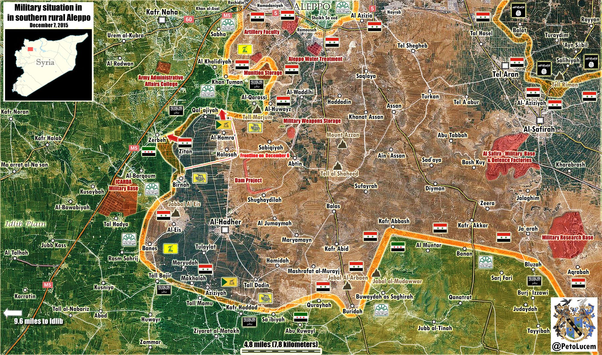
Possibly unfree File:Asa'ib Ahl al-Haq flag.svg
A file that you uploaded or altered, File:Asa'ib Ahl al-Haq flag.svg, has been listed at Wikipedia:Possibly unfree files because its copyright status is unclear or disputed. If the file's copyright status cannot be verified, it may be deleted. You may find more information on the file description page. You are welcome to add comments to its entry at the discussion if you object to the listing for any reason. Thank you. Stefan2 ( talk) 01:55, 6 November 2015 (UTC)
Possibly unfree File:Ayad Futayyih Khalifa al-Rawi.jpeg
A file that you uploaded or altered, File:Ayad Futayyih Khalifa al-Rawi.jpeg, has been listed at Wikipedia:Possibly unfree files because its copyright status is unclear or disputed. If the file's copyright status cannot be verified, it may be deleted. You may find more information on the file description page. You are welcome to add comments to its entry at the discussion if you object to the listing for any reason. Thank you. Stefan2 ( talk) 01:57, 6 November 2015 (UTC)
Possibly unfree File:Logo of Jeish Muhammad.jpeg
A file that you uploaded or altered, File:Logo of Jeish Muhammad.jpeg, has been listed at Wikipedia:Possibly unfree files because its copyright status is unclear or disputed. If the file's copyright status cannot be verified, it may be deleted. You may find more information on the file description page. You are welcome to add comments to its entry at the discussion if you object to the listing for any reason. Thank you. Stefan2 ( talk) 01:57, 6 November 2015 (UTC)
Possibly unfree File:Logo of Battalions of Muhammed al-Fatih.jpeg
A file that you uploaded or altered, File:Logo of Battalions of Muhammed al-Fatih.jpeg, has been listed at Wikipedia:Possibly unfree files because its copyright status is unclear or disputed. If the file's copyright status cannot be verified, it may be deleted. You may find more information on the file description page. You are welcome to add comments to its entry at the discussion if you object to the listing for any reason. Thank you. Stefan2 ( talk) 01:58, 6 November 2015 (UTC)
Possibly unfree File:Logo of Jaish al-Rashideen.jpeg
A file that you uploaded or altered, File:Logo of Jaish al-Rashideen.jpeg, has been listed at Wikipedia:Possibly unfree files because its copyright status is unclear or disputed. If the file's copyright status cannot be verified, it may be deleted. You may find more information on the file description page. You are welcome to add comments to its entry at the discussion if you object to the listing for any reason. Thank you. Stefan2 ( talk) 01:58, 6 November 2015 (UTC)
Possibly unfree File:Logo of Jund al-Rahman.gif
A file that you uploaded or altered, File:Logo of Jund al-Rahman.gif, has been listed at Wikipedia:Possibly unfree files because its copyright status is unclear or disputed. If the file's copyright status cannot be verified, it may be deleted. You may find more information on the file description page. You are welcome to add comments to its entry at the discussion if you object to the listing for any reason. Thank you. Stefan2 ( talk) 01:58, 6 November 2015 (UTC)
Possibly unfree File:Logo of Jaish al-Muslimeen.png
A file that you uploaded or altered, File:Logo of Jaish al-Muslimeen.png, has been listed at Wikipedia:Possibly unfree files because its copyright status is unclear or disputed. If the file's copyright status cannot be verified, it may be deleted. You may find more information on the file description page. You are welcome to add comments to its entry at the discussion if you object to the listing for any reason. Thank you. Stefan2 ( talk) 01:58, 6 November 2015 (UTC)
Possibly unfree File:Logo of the Empowerment Brigades.png
A file that you uploaded or altered, File:Logo of the Empowerment Brigades.png, has been listed at Wikipedia:Possibly unfree files because its copyright status is unclear or disputed. If the file's copyright status cannot be verified, it may be deleted. You may find more information on the file description page. You are welcome to add comments to its entry at the discussion if you object to the listing for any reason. Thank you. Stefan2 ( talk) 01:58, 6 November 2015 (UTC)
Possibly unfree File:Logo of Islamic Movement of Iraq's Mujahideen.png
A file that you uploaded or altered, File:Logo of Islamic Movement of Iraq's Mujahideen.png, has been listed at Wikipedia:Possibly unfree files because its copyright status is unclear or disputed. If the file's copyright status cannot be verified, it may be deleted. You may find more information on the file description page. You are welcome to add comments to its entry at the discussion if you object to the listing for any reason. Thank you. Stefan2 ( talk) 01:58, 6 November 2015 (UTC)
Possibly unfree File:Logo of 1920 Revolution Brigade.gif
A file that you uploaded or altered, File:Logo of 1920 Revolution Brigade.gif, has been listed at Wikipedia:Possibly unfree files because its copyright status is unclear or disputed. If the file's copyright status cannot be verified, it may be deleted. You may find more information on the file description page. You are welcome to add comments to its entry at the discussion if you object to the listing for any reason. Thank you. Stefan2 ( talk) 01:59, 6 November 2015 (UTC)
Possibly unfree File:Logo of the Front for Jihad and Change.png
A file that you uploaded or altered, File:Logo of the Front for Jihad and Change.png, has been listed at Wikipedia:Possibly unfree files because its copyright status is unclear or disputed. If the file's copyright status cannot be verified, it may be deleted. You may find more information on the file description page. You are welcome to add comments to its entry at the discussion if you object to the listing for any reason. Thank you. Stefan2 ( talk) 01:59, 6 November 2015 (UTC)
Possibly unfree File:Logo of the Jeish al-Taiifa al-Mansoura.jpeg
A file that you uploaded or altered, File:Logo of the Jeish al-Taiifa al-Mansoura.jpeg, has been listed at Wikipedia:Possibly unfree files because its copyright status is unclear or disputed. If the file's copyright status cannot be verified, it may be deleted. You may find more information on the file description page. You are welcome to add comments to its entry at the discussion if you object to the listing for any reason. Thank you. Stefan2 ( talk) 01:59, 6 November 2015 (UTC)
Possibly unfree File:Logo of the Al-Sadiqoun Bloc.jpg
A file that you uploaded or altered, File:Logo of the Al-Sadiqoun Bloc.jpg, has been listed at Wikipedia:Possibly unfree files because its copyright status is unclear or disputed. If the file's copyright status cannot be verified, it may be deleted. You may find more information on the file description page. You are welcome to add comments to its entry at the discussion if you object to the listing for any reason. Thank you. Stefan2 ( talk) 01:59, 6 November 2015 (UTC)
Reference errors on 9 November
![]() Hello, I'm
ReferenceBot. I have automatically detected that an edit performed by you may have introduced errors in referencing. It is as follows:
Hello, I'm
ReferenceBot. I have automatically detected that an edit performed by you may have introduced errors in referencing. It is as follows:
- On the Sudan Air Campaign page, your edit caused a broken reference name ( help). ( Fix | Ask for help)
Please check this page and fix the errors highlighted. If you think this is a false positive, you can report it to my operator. Thanks, ReferenceBot ( talk) 00:23, 10 November 2015 (UTC)
2015 Hama Offensive
You can update map 2015 Hama Offensive:
- Syrian army retake Al-Mughayr Tell-al-Sakhr Grain-Silos source also Al Bani and Tall Uthman under SAA. source source 37.52.27.49 ( talk) 11:23, 11 November 2015 (UTC)
Also the village of al-Shari`ah source and Barisha Jubb az-Zu'rur source also village Kafr Dulbah under SAA. see map 37.52.27.49 ( talk) 11:33, 11 November 2015 (UTC)
- Make this updates: SAA retake Mughayr,Tall Sakhr,Grain Silos and Al Bani near Khan Nabudah. here source source 95.134.186.238 ( talk) 16:38, 18 November 2015 (UTC)
- Also SAA captured Rashwah. source SOHR 95.134.186.238 ( talk) 16:47, 18 November 2015 (UTC)
Ways to improve Nottinghamshire County Council election, 1889
Hi, I'm Zppix. MrPenguin20, thanks for creating Nottinghamshire County Council election, 1889!
I've just tagged the page, using our page curation tools, as having some issues to fix. Please remember to add more than 1 source in your articles
The tags can be removed by you or another editor once the issues they mention are addressed. If you have questions, you can leave a comment on my talk page. Or, for more editing help, talk to the volunteers at the Teahouse. Ⓩⓟⓟⓘⓧ ( talk) 03:47, 14 November 2015 (UTC)
A belated welcome!


Here's wishing you a belated welcome to Wikipedia, MrPenguin20. I see that you've already been around a while and wanted to thank you for your contributions. Though you seem to have been successful in finding your way around, you may benefit from following some of the links below, which help editors get the most out of Wikipedia:
- Introduction
- The five pillars of Wikipedia
- Contributing to Wikipedia
- How to edit a page
- Help pages
- How to write a great article
- Editor's index to Wikipedia
Also, when you post on talk pages you should sign your name using four tildes (~~~~); that should automatically produce your username and the date after your post.
I hope you enjoy editing here and being a Wikipedian! If you have any questions, feel free to leave me a message on my talk page, consult Wikipedia:Questions, or place {{ helpme}} on your talk page and ask your question there.
Again, welcome! Ⓩⓟⓟⓘⓧ ( talk) 03:48, 14 November 2015 (UTC)
Welcome to Wikipedia: check out the Teahouse!
|
|
Rif Damashq map 2
You can update Rif Damashq map
- map for update here
- Also Syrian troops captured this Army base and Marj Al-Sultan Airbase. source source 178.95.150.71 ( talk) 10:06, 15 November 2015 (UTC)
- Please update this map. 37.53.151.231 ( talk) 19:11, 15 November 2015 (UTC)
- SAA retake captured and secured the Marj al Sultan - Al-Nawlah road and retake the villages Nawlah Hawash al-Dumal Ruwan and Marj As Sultan South - Military Helicopter Airbase also under control by SAA. source Please update map. 37.52.24.241 ( talk) 19:49, 25 November 2015 (UTC)
- You can update map in area of the city Darayya. SAA retake north and west part of the city. Here map from opp. source showed current situation in Darayya. here 37.52.30.223 ( talk) 14:28, 29 November 2015 (UTC)
- Need update map. 46.201.223.212 ( talk) 18:49, 4 December 2015 (UTC)
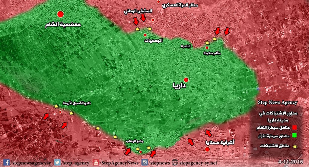
- SAA with support Hizbullah seize over wide areas in Marj as-Sultan in eastern Ghouta after intense clashes with opposition forces. source Sûriyeya ( talk) 19:10, 6 December 2015 (UTC)
Map of Syrian civil war
You can update this map Syrian civil war near the town Mahin here and in Latakia here here and in other areas. here 95.134.222.195 ( talk) 08:47, 24 November 2015 (UTC)
Hi,
You appear to be eligible to vote in the current
Arbitration Committee election. The
Arbitration Committee is the panel of editors responsible for conducting the Wikipedia
arbitration process. It has the authority to enact binding solutions for disputes between editors, primarily related to serious behavioural issues that the community has been unable to resolve. This includes the ability to impose
site bans,
topic bans, editing restrictions, and other measures needed to maintain our editing environment. The
arbitration policy describes the Committee's roles and responsibilities in greater detail. If you wish to participate, you are welcome to
review the candidates' statements and submit your choices on
the voting page. For the Election committee,
MediaWiki message delivery (
talk) 16:50, 24 November 2015 (UTC)
Nomination of United Kingdom general election, 2015 (Edinburgh) for deletion
A discussion is taking place as to whether the article United Kingdom general election, 2015 (Edinburgh) is suitable for inclusion in Wikipedia according to Wikipedia's policies and guidelines or whether it should be deleted.
The article will be discussed at Wikipedia:Articles for deletion/United Kingdom general election, 2015 (Edinburgh) until a consensus is reached, and anyone is welcome to contribute to the discussion. The nomination will explain the policies and guidelines which are of concern. The discussion focuses on high-quality evidence and our policies and guidelines.
Users may edit the article during the discussion, including to improve the article to address concerns raised in the discussion. However, do not remove the article-for-deletion notice from the top of the article. LukeSurl t c 17:00, 30 November 2015 (UTC)
Australian referendum, 1967 (Aboriginals)
Nice map, MrPenguin20. Should the ACT be grey, like the NT? Wikiain ( talk) 02:07, 4 December 2015 (UTC)
- Oh woops. Yes indeed! Thanks for pointing that out. MrPenguin20 ( talk) 02:44, 4 December 2015 (UTC)
Aleppo Offensive Map
I think it neads an update. Plus, Please, Archive your Talk Page. It's became too heavy and long. P. Pajouhesh ( talk) 09:01, 7 December 2015 (UTC)
- Good idea! MrPenguin20 ( talk) 16:50, 7 December 2015 (UTC)
- ^ /info/en/?search=Cities_and_towns_during_the_Syrian_civil_war
- ^ /info/en/?search=Cities_and_towns_during_the_Syrian_civil_war
- ^ /info/en/?search=Cities_and_towns_during_the_Syrian_civil_war
- ^ /info/en/?search=Cities_and_towns_during_the_Syrian_civil_war
- ^ "Clashes in the win and martyrs in Daraa". Syriahr.com.
| This page is an archive of past discussions. Do not edit the contents of this page. If you wish to start a new discussion or revive an old one, please do so on the current talk page. |
Khuzestan
See Khuzestan conflict article, your additions are welcome. Greyshark09 ( talk) 12:22, 26 May 2013 (UTC)
Ba'ath Egypt
This source directly refers to the Ba'ath Party of Assem Qanso in Egypt, and its relations to Syria, they have nothing to do with the Iraqi Ba'ath movement.. A Syrian Ba'ath chapter does exist in Egypt, but as you well know, the Iraqi movement has historically been more active and more popular in other Arab countries. Of course, the chapter may have dissolved or become inactive by this time, or its just very small. -- TIAYN ( talk) 14:43, 5 July 2013 (UTC)
- I understand completely... I've tried but failed to find any information on some information on the Iraqi and Syrian Ba'ath Party in Palestine... As you may know the Arab Liberation Front and As-Sa'iqa are only front groups, and not the actual party organizations... -- TIAYN ( talk) 15:03, 5 July 2013 (UTC)
- Since you created the page, you may be interested in the fact that Fawzi Mutlaq al-Rawi is no longer Regional Secretary of the Iraqi Ba'ath... I have no idea when it happened, but Mouteb Shenan apparently is the new leader.... :) -- TIAYN ( talk) 13:10, 10 July 2013 (UTC)
Latakia offensive
Just wanted to say that your map looks great, but you need to color Jisr al-Shugur in the upper right corner as government territory because the town has been confirmed for some time to be government-held. Otherwise, nice work! EkoGraf ( talk) 16:47, 21 August 2013 (UTC)
- You can verify the info on this at Cities and towns during the Syrian civil war, but from the reliable news sources I've seen and the article I pointed out for you the whole town is at the moment government-held as well as one other smaller town just to the northeast of it. So in essence at least the immediate area in and arround Jisr al-Shugur is at the moment under government control. EkoGraf ( talk) 07:47, 22 August 2013 (UTC)
Hi, I just wanted to add to the praise for the map. Are you planning on doing any more maps like it? Esn ( talk) 10:38, 23 August 2013 (UTC)
Deir Ezzor Map
Rebels took the entire island Hawiqa is situated on. http://www.reuters.com/article/2013/08/20/us-syria-crisis-east-idUSBRE97J0P520130820 Sopher99 ( talk) 11:16, 24 August 2013 (UTC)
- Cool thanks. I'll update the map! MrPenguin20 ( talk) 11:20, 24 August 2013 (UTC)
The army hit rebel forces in Hawiqa district on Tuesday with tanks and multiple rocket launchers, and also battled them in territory separating Hawiqa from the district of Joura, opposition sources in the city said. The regime is trying to regain Hawiqa because it cannot afford the rebels to be so close to its most important stronghold of Joura and the army camp there, said Abu al-Tayyeb al-Deiri of the opposition Deir al-Zor Media Centre. http://www.reuters.com/article/2013/08/20/us-syria-crisis-east-idUSBRE97J0P520130820 95.134.222.207 ( talk) 09:36, 2 September 2013 (UTC)
- Thanks. I'll update the map to show the new government offensive. MrPenguin20 ( talk) 09:37, 2 September 2013 (UTC)
Thank you for making a map for Deir ez-Zor city. It was long overdue. I have a few suggestions:
1-
Sina'a neighbourhood should be blue because the article (
Deir ez-Zor clashes (2011–present)) says: “On 13 August, … 4 rebels killed by clashes in … Sina'a neighbourhoods.” Clashes happen there on a regular basis...
2-
Jebaylah neighbourhood should be labeled because it is mentioned by the article (same sentence as above) and it is often mentioned by the media as an important clash spot. You already have it in blue west of Hamidiyah.
3-
al-Rashdiya neighbourhood should be blue because the article says: “On 14 June, ... Clashes are taking place between rebel and regular forces in … al-Rashdiya neighbourhood ...” It is still the case today…
4-
Al-Qussour neighbourhood should be labeled because it is an important government stronghold. By the way, you have the label “Dumar” below “Joura”, however, it is not on Wikimapia and I have never heard of it...
Tradedia (
talk) 03:43, 8 September 2013 (UTC)
- Thanks! I've just uploaded a new map fixing the mistakes you mentioned. Let me know if you spot any other problems! MrPenguin20 ( talk) 14:09, 15 September 2013 (UTC)
Hama offensive MAP
Hi, I just saw your map of the province of Hama, again, it's a good job ;) But when this offensive, the Hama-Khan Shaykhun highway was under the control of the army. The town of Khan Shaykhun and its surroundings are also controlled by the army. And during this offensive, the army to keep control of Taybat al-Imam and the army took control of Halfaya ;) Rogal Dorm ( talk) 20:29, 6 September 2013 (UTC)
- I just saw this map concerned the first Hama offensive, sorry. The only thing to change is then Hama-Khan Shaykhun highway under military control, and Khan Shaykhun controlled by the army ;) Sorry :s Rogal Dorm ( talk) 20:42, 6 September 2013 (UTC)
- No that's great actually! I was actually planning on making a map showing the 2nd offensive, and so any information is much appreciated! I'll get started on fixing the map/uploading the one showing the 2nd offensive.
MrPenguin20 (
talk) 20:51, 6 September 2013 (UTC)
- Updated the map. How does that look?
MrPenguin20 (
talk) 21:08, 6 September 2013 (UTC)
- I think That the east of Khan Shaykhun is under the control of the army because as you can see here
[1], there is a military base (al khazanat), not attacked and still under military control. It is possible to make it appear on the map ?
Rogal Dorm (
talk) 21:37, 6 September 2013 (UTC)
- Well spotted! There is a small army base to the immediate south east of Khan Shaykhun and north of Murik; I guess that must be it? MrPenguin20 ( talk) 21:47, 6 September 2013 (UTC)
- Updated now.
MrPenguin20 (
talk) 22:01, 6 September 2013 (UTC)
- Yes ;) For Al tamanan'a, directly east of the base, I find this <redacted due to spam blacklisting of the URL>.This site information said that the city was taken by the army in 2012, and since then, there is nothing new coming from this city. I think we can be considered under the control of the army until there is no evidence to the contrary. So we can conclude that the east of Khan Shaykhun is controlled by the army. What do you think?
Rogal Dorm (
talk) 22:06, 6 September 2013 (UTC)
- Maybe. I might have missed a bit referring to government control of the village, but the site seems to me to mostly refer to the operations as raids being conducted from neighboring Alawite villages, suggesting the government isn't in control, but instead just sometimes makes forays into such villages (resulting in clashes). I think these operations are the same ones referenced in
this article, where again they're just referred to as raids. Although even if it's just raids being conducted against the town, I'd say it probably still merits moving the frontline a little bit closer to al-Tamana.
MrPenguin20 (
talk) 22:27, 6 September 2013 (UTC)
- I agree with the current map
Rogal Dorm (
talk) 22:45, 6 September 2013 (UTC)
- Cool, I'll get started on a map of the 2013 Offensive.
MrPenguin20 (
talk) 22:48, 6 September 2013 :::::::::: ;) Okay. You think it should show on the map the Hama military airport ? And all military bases ?
Rogal Dorm (
talk) 22:52, 6 September 2013 (UTC) Yeah, good idea!
MrPenguin20 (
talk) 22:57, 6 September 2013 (UTC)
- There is Hama military airport, and military zones south of Hama along the highway, a military base is glued to Hama southeast. And a military field north of Khattab. Another military area northeast of Hama. You see others that can put on the map? Rogal Dorm ( talk) 23:13, 6 September 2013 (UTC)
- Cool, I'll get started on a map of the 2013 Offensive.
MrPenguin20 (
talk) 22:48, 6 September 2013 :::::::::: ;) Okay. You think it should show on the map the Hama military airport ? And all military bases ?
Rogal Dorm (
talk) 22:52, 6 September 2013 (UTC) Yeah, good idea!
MrPenguin20 (
talk) 22:57, 6 September 2013 (UTC)
- I agree with the current map
Rogal Dorm (
talk) 22:45, 6 September 2013 (UTC)
- Maybe. I might have missed a bit referring to government control of the village, but the site seems to me to mostly refer to the operations as raids being conducted from neighboring Alawite villages, suggesting the government isn't in control, but instead just sometimes makes forays into such villages (resulting in clashes). I think these operations are the same ones referenced in
this article, where again they're just referred to as raids. Although even if it's just raids being conducted against the town, I'd say it probably still merits moving the frontline a little bit closer to al-Tamana.
MrPenguin20 (
talk) 22:27, 6 September 2013 (UTC)
- Yes ;) For Al tamanan'a, directly east of the base, I find this <redacted due to spam blacklisting of the URL>.This site information said that the city was taken by the army in 2012, and since then, there is nothing new coming from this city. I think we can be considered under the control of the army until there is no evidence to the contrary. So we can conclude that the east of Khan Shaykhun is controlled by the army. What do you think?
Rogal Dorm (
talk) 22:06, 6 September 2013 (UTC)
- I think That the east of Khan Shaykhun is under the control of the army because as you can see here
[1], there is a military base (al khazanat), not attacked and still under military control. It is possible to make it appear on the map ?
Rogal Dorm (
talk) 21:37, 6 September 2013 (UTC)
- Updated the map. How does that look?
MrPenguin20 (
talk) 21:08, 6 September 2013 (UTC)
- No that's great actually! I was actually planning on making a map showing the 2nd offensive, and so any information is much appreciated! I'll get started on fixing the map/uploading the one showing the 2nd offensive.
MrPenguin20 (
talk) 20:51, 6 September 2013 (UTC)
- Thanks! I'll upload the updated maps (including this, the 2nd Hama Offensive, and the Rif Dimashq Offensive) at the weekend (would have done so before, but been really busy this week). In the meantime though if anything else changes or you notice any other problems then naturally feel free to post it and it'll be fixed for the new versions :) MrPenguin20 ( talk)
2nde Hama offensive (2013)
To illustrate this offensive will require a any map of the province of Hama ;) Rogal Dorm ( talk) 13:14, 7 September 2013 (UTC)
- Yeah, do you think I'll need to make a bigger map showing the whole province for this offensive considering so much of it happens further to the east?
MrPenguin20 (
talk) 14:55, 15 September 2013 (UTC)
- It should a map showing the whole province ;)
Rogal Dorm (
talk) 16:12, 15 September 2013 (UTC)
- Are you ready ? :)
Rogal Dorm (
talk) 16:29, 26 September 2013 (UTC)
- Ok I've uploaded a provisional version to the page for now - none of the towns South East of Salamiyah are named at the moment however, so I'll need to fix that.
MrPenguin20 (
talk) 15:25, 27 September 2013 (UTC)
- Ok ;)
- Ok I've uploaded a provisional version to the page for now - none of the towns South East of Salamiyah are named at the moment however, so I'll need to fix that.
MrPenguin20 (
talk) 15:25, 27 September 2013 (UTC)
- Are you ready ? :)
Rogal Dorm (
talk) 16:29, 26 September 2013 (UTC)
- It should a map showing the whole province ;)
Rogal Dorm (
talk) 16:12, 15 September 2013 (UTC)
1- Taybat al-Imam is under army control
[2]
2- You want to write all the towns captured by the army ? I can find the names ;)
Rogal Dorm (
talk) 22:15, 27 September 2013 (UTC)
- Oops can't believe I missed Taybat al-Imam! I've added the names of a bunch of the villages in the South East to the new version, but yeah if there's towns of interest or anything that I've missed then please say :).
MrPenguin20 (
talk) 00:45, 28 September 2013 (UTC)
- For me, the map is good now ;)
Rogal Dorm (
talk) 00:28, 29 September 2013 (UTC)
- Great! I'll get started on a map for the
2nd Rif Dimashq offensive.
MrPenguin20 (
talk) 01:37, 29 September 2013 (UTC)
- Ok ;) Rogal Dorm ( talk) 09:17, 29 September 2013 (UTC)
- Great! I'll get started on a map for the
2nd Rif Dimashq offensive.
MrPenguin20 (
talk) 01:37, 29 September 2013 (UTC)
- For me, the map is good now ;)
Rogal Dorm (
talk) 00:28, 29 September 2013 (UTC)
- Oops can't believe I missed Taybat al-Imam! I've added the names of a bunch of the villages in the South East to the new version, but yeah if there's towns of interest or anything that I've missed then please say :).
MrPenguin20 (
talk) 00:45, 28 September 2013 (UTC)
Rif Dimashq offensive map
The M5 highway was under the control of the army before the attack, so that Daraya and Moadamyeh are completely surrounded. Like for the highway M1, Douma is completely surrounded Rogal Dorm ( talk) 13:22, 7 September 2013 (UTC)
- Here are several other information:
1- At the east of the M5 highway Al-Sabinah and Hujayrah are contested like Deir Salman, Yalda, Babbila and Beit sahem, Hatitat al-Turkuman and Deir al-Asafir, all this city attacked by the army
[3]
2- Qadam also contested, the west is controlled by the army and the east is controled by the rebels, the "border" is the rapid way.
I have more information, but I do not have time now
Rogal Dorm (
talk) 16:46, 14 September 2013 (UTC)
Yalda under the full control of the Syrian army! And army captured the city Deir Salman. http://www.elnashra.com/news/show/659876 37.55.213.139 ( talk) 19:44, 14 September 2013 (UTC)
- Updated - thoughts?
MrPenguin20 (
talk) 13:45, 15 September 2013 (UTC)
- Good job ;)
- Updated - thoughts?
MrPenguin20 (
talk) 13:45, 15 September 2013 (UTC)
1- Is it possible to show on the map: The Adra prison (Under Army control), The Marj As Sultan Air Base (Under Rebel control), The siege of "Brigade 39" (Under Army control), the siege of Brigade 22 (Under Army control), the base of the Special Forces (Under Army control, betwen Harasta and Qaboun), the Mezzeh military airport (Under Army control), the base of the 4th Division (Under Army control), the siege of the Republican Guard Brigade (Under Army control) and the base of Al-Drejj (Under Army control, in the north of Jamraya). It's possible ?
[4]
2- Daraya is contested
Rogal Dorm (
talk) 16:10, 15 September 2013 (UTC)
- Shebaa in under army control Rogal Dorm ( talk) 20:10, 22 September 2013 (UTC)
- Updated now, although I'm not sure if the 22 Brigade base is marked correctly. Btw I'm working on maps for the Damascus offensives atm, and I've uploaded one for the
February 2013 offensive. It look about right?
MrPenguin20 (
talk) 00:30, 23 September 2013 (UTC)
- According to reports, the rebels have not taken this base. This base allowed the army to protect the south of Adra because rebels fighter arrived by the desert. For other map, I'll look later ;) Rogal Dorm ( talk) 11:38, 23 September 2013 (UTC)
- Updated now, although I'm not sure if the 22 Brigade base is marked correctly. Btw I'm working on maps for the Damascus offensives atm, and I've uploaded one for the
February 2013 offensive. It look about right?
MrPenguin20 (
talk) 00:30, 23 September 2013 (UTC)
Syrian army controls Najhah. http://www.dailystar.com.lb/News/Middle-East/2013/Oct-01/233135-rights-group-finds-mass-graves-near-damascus.ashx#axzz2gTvJasaY 92.113.218.45 ( talk) 16:13, 1 October 2013 (UTC)
- Thanks! I think it might already be marked as being under SAA control though (although not labeled) - Najha's just slightly due east of the Sahya Mountains military base. MrPenguin20 ( talk) 16:21, 1 October 2013 (UTC)
Rif Dimashq offensive (March 2013–present)
I am considering if we should close the article Rif Dimashq offensive (March 2013–present) as a Partial Syrian Army victory or just Syrian Army victory, due to the fact that for two weeks all offensive operations by the Army ceased after the gas attacks and during the threat of air-strikes by the West. Before that for five months all operations by the military were continues. If major offensive operations by ether side are launched once again we open up a new article. Would you agree? EkoGraf ( talk) 12:29, 15 September 2013 (UTC)
- Sounds about right to me. MrPenguin20 ( talk) 12:35, 15 September 2013 (UTC)
to agree! Here is a map of the situation around Damascus https://upload.wikimedia.org/wikipedia/commons/6/68/Military_situation_in_Damascus_region_as_of_15th_of_September_2013.png — Preceding unsigned comment added by 95.134.192.148 ( talk) 13:01, 15 September 2013 (UTC)
- Be careful, someone change the card with the events that occurred after the end of the offensive, would you return to the map before? I will create an article this week for the new offensive Rogal Dorm ( talk) 15:23, 16 October 2013 (UTC)
Damascus offensive (2013) Map
This map is good ! Congratulations ! Just the Adra prison has not been captured by the rebels and Yarmouk was under rebel control since the previous rebel offensive Rogal Dorm ( talk) 18:29, 23 September 2013 (UTC)
Shebaa and Dair Salman now under the full control of the army http://en.wikipedia.org/wiki/Template:Syrian_civil_war_detailed_map http://www.presstv.ir/detail/2013/09/19/324913/syria-army-continues-mopup-ops/ 95.135.242.44 ( talk) 05:36, 24 September 2013 (UTC)
- Ok. But It is in another offensive ;) Rogal Dorm ( talk) 16:29, 26 September 2013 (UTC)
Rif Dimashq offensive (August–October 2012) Map
You want to create a map on this offensive ? Rogal Dorm ( talk) 09:11, 8 October 2013 (UTC)
- Yeah it should be uploaded later today! Got a bit distracted doing flags for the Bahraini Defence Force....
MrPenguin20 (
talk) 09:47, 8 October 2013 (UTC)
- No problem, I am always ready to help you;)
Rogal Dorm (
talk) 11:13, 8 October 2013 (UTC)
- Thanks :). There's a new version uploaded now!
MrPenguin20 (
talk) 15:14, 8 October 2013 (UTC)
-
Adra's prison, which is between Douma and Adra is an important point of control of the army, it has never been captured by the rebels ;)
Rogal Dorm (
talk) 19:25, 8 October 2013 (UTC)
- Updated now!
MrPenguin20 (
talk) 23:35, 8 October 2013 (UTC)
- In this offensive, rebels fighter seized control of the Marj al-Sultan Military airbase in Eastern Ghouta
Rogal Dorm (
talk) 10:03, 9 October 2013 (UTC)
- Yeah I noticed that, I just wasn't sure if it was included in the offensive since it fell in late November whereas the article seems to focus on the August-October fighting. Hmm actually now that I'm thinking about it, I think maybe the section about rebels taking Marj al-Sultan should be in
this article, since that article talks about the fighting from 7 November and the airbase fell on the 25 November. In that case I'll still have to change that articles map as the fall of the airbase isn't shown at the moment. Also I noticed AOnline just asked for a map of the Daraa offensives - fancy helping me out with that too?
MrPenguin20 (
talk) 13:16, 9 October 2013 (UTC)
- Yes I think we can include the fall of the base in this map. For Deraa, yes I can help you ;) Rogal Dorm ( talk) 17:16, 9 October 2013 (UTC)
- Yeah I noticed that, I just wasn't sure if it was included in the offensive since it fell in late November whereas the article seems to focus on the August-October fighting. Hmm actually now that I'm thinking about it, I think maybe the section about rebels taking Marj al-Sultan should be in
this article, since that article talks about the fighting from 7 November and the airbase fell on the 25 November. In that case I'll still have to change that articles map as the fall of the airbase isn't shown at the moment. Also I noticed AOnline just asked for a map of the Daraa offensives - fancy helping me out with that too?
MrPenguin20 (
talk) 13:16, 9 October 2013 (UTC)
- In this offensive, rebels fighter seized control of the Marj al-Sultan Military airbase in Eastern Ghouta
Rogal Dorm (
talk) 10:03, 9 October 2013 (UTC)
- Updated now!
MrPenguin20 (
talk) 23:35, 8 October 2013 (UTC)
-
Adra's prison, which is between Douma and Adra is an important point of control of the army, it has never been captured by the rebels ;)
Rogal Dorm (
talk) 19:25, 8 October 2013 (UTC)
- Thanks :). There's a new version uploaded now!
MrPenguin20 (
talk) 15:14, 8 October 2013 (UTC)
- No problem, I am always ready to help you;)
Rogal Dorm (
talk) 11:13, 8 October 2013 (UTC)
Daraa
First of all i would like to thank you for the maps(Syrian civil war) that you created. They are very useful for the users who is fallowing the current situation in the country. As you know, we are using some of your maps at /info/en/?search=Template:Syrian_civil_war_detailed_map. So i would like to ask you if you could creat a detailed map for Darra. Since the city is heavy contested we need a map which can show the situation in there. Once again, thanks for your hard work. AOnline ( talk) 12:59, 9 October 2013 (UTC)
- Yeah sure I'll get working on it! MrPenguin20 ( talk) 13:16, 9 October 2013 (UTC)
Looking forward for the map. Thanks! AOnline ( talk) 17:34, 9 October 2013 (UTC)
- Sorry but I did not understand or card would be displayed Rogal Dorm ( talk) 21:30, 11 October 2013 (UTC)
- I would like to add my voice to that of AOnline concerning the big need for a current map of Daraa city to be included in Template:Syrian civil war detailed map. It should be a map of the city alone (we already have a detailed map of the province) and be up-to-date. It should represent the government in red, the rebels in green and disputed areas in blue. Thanks in advance! Tradedia (talk) 00:46, 12 October 2013 (UTC)
- Ok I've got a provisional version uploaded here, it look about right? MrPenguin20 ( talk) 16:02, 18 October 2013 (UTC)
I also think it is necessary to update map of the city Dara. Here is a map showing situation at beginning of December. Hanibal911 ( talk) 21:51, 4 February 2014 (UTC)
- Thanks. I wouldn't be surprised if the Dara frontlines had changed by now, but as a source Syrian Perspective seems to be quite contested on Wikipedia due to it being perceived as having a pro-government stance. MrPenguin20 ( talk) 17:48, 13 February 2014 (UTC)
That pro opposition [ map but on this map it is difficult to fully assess the situation. And pro opposition source said than the village Atman under the control of the army and the militants tried to attack village. source Hanibal911 ( talk) 18:40, 13 February 2014 (UTC)
Need to change the map of Dara this the pro opposition version of the map and you can based on it alter the map. with only one exception because the village Atman contested. source Hanibal911 ( talk) 21:13, 22 March 2014 (UTC)
- Updated!
MrPenguin20 (
talk) 21:59, 29 March 2014 (UTC)
- The Syrian army controls around 60 percent of the city of Daraa including
Daraa al-Mahatta, and the part of Daraa al-Balad known as
al-Manshiya rebels control only rest part of Daraa al-Balad, including the area known as al-Sadd and the adjacent Palestinian refugee camp.
Al Akhbar
Hanibal911 (
talk) 18:10, 4 April 2014 (UTC)
- Thanks. Changed now! :)
MrPenguin20 (
talk) 21:23, 8 April 2014 (UTC)
- Pro opposition source says that the Syrian army captured the city Naima to east of the city Dara.
source And once again thank you for your edit.
Hanibal911 (
talk) 07:03, 9 April 2014 (UTC)
- Thanks. I'm not entirely clear whether Labrousse was saying that the SAA had taken it, or whether he was saying they would break the siege if they took it. So for the moment I've changed the map to show the SAA advance on the town from the east/west/south (as per another of his tweets), and then if anywhere/anyone else mentions that the SAA has taken Naimah I'll change the town to government control. MrPenguin20 ( talk) 12:36, 9 April 2014 (UTC)
- Pro opposition source says that the Syrian army captured the city Naima to east of the city Dara.
source And once again thank you for your edit.
Hanibal911 (
talk) 07:03, 9 April 2014 (UTC)
- I think it is worth noting the presence of the army near the town of Naima. Because
source said that the clashes between regular forces and rebels on the outskirts of Naima on amid shelling of regular troops areas in the town.
Hanibal911 (
talk) 09:27, 11 April 2014 (UTC)
- KK. What I've done is I've marked the town as contested and extended the arrows showing the government movement.
MrPenguin20 (
talk) 20:37, 11 April 2014 (UTC)
- Thanks for the timely update.
Hanibal911 (
talk) 21:01, 11 April 2014 (UTC)
- No problem! Thanks for keeping me updated :). I was thinking of potentially making another map - any article you think particularly needs one?
MrPenguin20 (
talk) 21:04, 11 April 2014 (UTC)
- Maybe! Hanibal911 ( talk) 21:16, 11 April 2014 (UTC)
- No problem! Thanks for keeping me updated :). I was thinking of potentially making another map - any article you think particularly needs one?
MrPenguin20 (
talk) 21:04, 11 April 2014 (UTC)
- Thanks for the timely update.
Hanibal911 (
talk) 21:01, 11 April 2014 (UTC)
- KK. What I've done is I've marked the town as contested and extended the arrows showing the government movement.
MrPenguin20 (
talk) 20:37, 11 April 2014 (UTC)
- Thanks. Changed now! :)
MrPenguin20 (
talk) 21:23, 8 April 2014 (UTC)
- The Syrian army controls around 60 percent of the city of Daraa including
Daraa al-Mahatta, and the part of Daraa al-Balad known as
al-Manshiya rebels control only rest part of Daraa al-Balad, including the area known as al-Sadd and the adjacent Palestinian refugee camp.
Al Akhbar
Hanibal911 (
talk) 18:10, 4 April 2014 (UTC)
Syrian troops are fighting against the rebels in Gharz prison in Deraa province. SOHR Hanibal911 ( talk) 20:01, 6 May 2014 (UTC)
- I think that the battles are conducted in the southern area of Dara. SOHR said that regime forces opened heavy machine-gun fire on areas in Tariq al-Sad neighbourhood in the city Dar'a. SOHR Hanibal911 ( talk) 06:00, 19 August 2014 (UTC)
2013 Libyan coup d'état attempt
Dear Mr Penguin 20,
I've read your article about the 2013 Libyan coup d'état attempt. I am the editor of the Spanish language version and, as I can see, you have quite knowledge of the topic. Therefore, I would like to ask you a question:
As you know, Zeidan has said that a political party was behind the coup. Today he has added that he has evidences against 4 or 5 Congress Members. Since the Justice and Construction Party is the only one with that number of representatives (besides the liberals), can we take it as a confirmation of the role of the islamists?
Thanks for your time. I hope I haven't been of a bother -- 80.30.114.95 ( talk) 19:03, 14 October 2013 (UTC)
- Happy to help :). Certainly some people have been suggesting the Justice and Construction Party was involved, although there's also been some talk about Abdurrahman Sewehli and the Union for Homeland. As I understand if Zeidan claimed yesterday that those responsible don't belong to a particular party, and that he will publicly name those responsible in the next GNC session. As such J&C Party Members might have been involved, but their involvement might not be representative of the wider J&C Party. Since he's apparently going to name those responsible though, I'm personally just waiting until this announcement before updating the English page to show which political groups/figures were involved. MrPenguin20 ( talk) 19:55, 14 October 2013 (UTC)
- Could you please send me a reference to that hypothesis? I would be personally interested in reading about it. However, even if all the group Congressmen were involved, there would 2 more for another party. In that case, Zeidan would be talking about political forces (in the plural form), wouldn't he? Anyway, we just have to wait =D It has been a pleasure talking to you -- 80.30.114.95 ( talk) 13:46, 15 October 2013 (UTC)
Deir Ezzor
Rebels secure much of the city, syrian army retreats to Joura, mark qussor contested.
https://www.facebook.com/syriaohr/posts/433712646737079 Sopher99 ( talk) 20:39, 16 October 2013 (UTC)
- How does the new version look? MrPenguin20 ( talk) 15:44, 18 October 2013 (UTC)
You could update map. Here is a map showing situation at beginning of December. Hanibal911 ( talk) 09:48, 4 February 2014 (UTC)
- That's great! Updated now. MrPenguin20 ( talk) 21:30, 4 February 2014 (UTC)
Thank you. Hanibal911 ( talk) 21:39, 4 February 2014 (UTC)
The regime controls multiple areas within the city of Deir Ezzor, mainly the Joura and Al-Qousour neighborhoods and the Tala'eh area, in addition to military bases such as the military airport, the Tala'eh camp, Al-Jabal, and Brigade 137 on the outskirts of the city. Meanwhile, the most important neighborhoods in the city are controlled by opposition forces, including Rashdiyyah and Huwayqah. The opposition has also made tremendous progress in other besieged neighborhoods, including Al-Sinaaa, Al-Ummal, Al-Mouwazzafin, and Al-Jubaylah. But in these areas are still fighting and they should be marked as contested. Now News Hanibal911 ( talk) 20:13, 13 March 2014 (UTC)
You can correct the map because Huwayqah neighborhood not under the rebel control. Because pro opposition source said that the Huwayqah neighbourhood was also exposed to shelling by the FSA rebel earlier in a try to target the headquarters of the regime forces, resulting in a number of casualties. Ara News Hanibal911 ( talk) 08:51, 27 March 2014 (UTC)
- Hmm yeah. Most maps I've seen have Hiweqa under opposition control - I wonder where about the headquarters could be. It probably doesn't mean central Hawiqa, as if it were that then it'd mean that the Headquarters would be effectively surrounded. Then again, the Governor's house is in that area - could be that? Alternatively it might be in Western Hawiqa/Basatin al-Nahr area. MrPenguin20 ( talk) 22:13, 29 March 2014 (UTC)
Violent clashes broke out between regular forces and islamic fighters in the neighbourhoods of al-Jbeila and al-Sina’a. source Hanibal911 ( talk) 17:38, 26 April 2014 (UTC)
- Al Hweqa neighborhood should be marked as contested because the pro opposition source said that in this neighborhood clashes the army vs rebels. source Hanibal911 ( talk) 10:33, 28 May 2014 (UTC)
- Updated!
MrPenguin20 (
talk) 12:52, 18 June 2014 (UTC)
- You can update the map! Violent clashes between regime forces and Islamic battalions in al-Rashedya neighborhood.
source
Hanibal911 (
talk) 11:05, 27 June 2014 (UTC)
- Took a while, but updated now! MrPenguin20 ( talk) 00:13, 1 July 2014 (UTC)
- You can update the map! Violent clashes between regime forces and Islamic battalions in al-Rashedya neighborhood.
source
Hanibal911 (
talk) 11:05, 27 June 2014 (UTC)
APPU
Hi. Great work on the APPU article, really interesting piece of history. -- Soman ( talk) 14:38, 18 October 2013 (UTC)
- Thanks! Thanks for your help too :). Yeah I've been trying to expand the articles relating to Saudi left wing politics, it's just a shame there seems to generally be so few sources on it!
MrPenguin20 (
talk) 17:16, 18 October 2013 (UTC)
- Yes. Before Google Books, it was really hard to find anything online, at least in non-Arabic sources, about the Saudi left. There is a book, in Arabic, released sometime around 2008 or 2009, that gives more detail on the Gulf left. It would be great to include some material from there, I'll try to google it up. --
Soman (
talk) 17:42, 18 October 2013 (UTC)
- Yeah that sounds great! Let me know if you find it! MrPenguin20 ( talk) 17:43, 18 October 2013 (UTC)
- Yes. Before Google Books, it was really hard to find anything online, at least in non-Arabic sources, about the Saudi left. There is a book, in Arabic, released sometime around 2008 or 2009, that gives more detail on the Gulf left. It would be great to include some material from there, I'll try to google it up. --
Soman (
talk) 17:42, 18 October 2013 (UTC)
Aleppo offensive
Good work on the Aleppo offensive map! A few questions/corrections/suggestions:
- What are the bright red lines supposed to show?
- There's too much white space. While I could understand leaving areas that are in contested areas blank, your map extends to Saraqeb, which is undisputedly rebel.
- It should be made clearer that Kuwayris is government-held. That's not immediately obvious here.
- As far as I am aware, Safira city is totally under rebel control (for now), whereas your map shows it as divided.
- Abu Zuhur Airbase has been fully besieged for a long time with no serious efforts to relieve it. On your map it looks like it may be connected to other government ares. I also am sceptical as to whether the town of Abu Zuhur is government-held.
Regards, Lothar von Richthofen ( talk) 04:43, 19 October 2013 (UTC)
- Yeah what I mostly tend to do is upload a map showing a general outline of the strategic situation, and then work to fix all the problems, so thanks a lot for all the suggestions. I've edited the map to reflect pretty much all of them. The only thing that's not fully fixed yet is there's still some white in the bottom right hand corner of the map, as I was unsure of ownership in the greater Khanasser area. Would you say that government control is limited to the general area surrounding the road, or is it broader in the Khanasser area? Also the red lines were intended to show the government lines before the offensive, to make it clearer how much land has changed hands over the course of the offensive. How accurately it does this is another matter entirely... MrPenguin20 ( talk) 18:17, 19 October 2013 (UTC)
- Based on the fact that a lot of rebel videos showing the advance of government troops seem to be filmed in the cliffs and hills above the road, I wouldn't extend government control too far away from the it. At the same time, it is a frontline area and it stands to reason that the army would be conducting operations in those areas to keep rebels from cutting off the road again. What you have now for this seems fine, honestly, until better information arises.
- In that case, the red lines are wrong, near as I can tell. The stretch of road between Safira city and Khanasir was under rebel control prior to the offensive. It's been recaptured by the government now, but only after very bitter fighting.
- In late September, rebels launched an offensive of their own which led to the capture of the cluster of green dots in that area that are on the detailed map. Ahrar al-Sham released this map the day after the start of the offensive, which shows that the defence factories were connected to the main part of Aleppo city at that time. By six days after, they had captured territory up to here [1], severing one of the main roads but not totally cutting the factories off from the city. SANA reported that the army "recaptured" Turkan and Tall 'Abur, but honestly I don't think they had ever fallen out of their control; given SANA's generally abysmal credibility and the movements on the ground, I think that they just threw them in to inflate their "victory count".
- All this taken into account, the question remains as to whether the factories were connected to the research facility beforehand. Ahrar al-Sham's map and the aforementioned rebel control over the plains would seem to indicate that they weren't, so an enclave like this is possible, though I wouldn't rule out a narrow connection like this.
- Also, SOHR reported that a small detachment split off at Hakla to try and cross Lake Jabbul and relive Kuwayris. No further news from this, which means they were probably wiped off the map (really stupid move, IMO), but it should be indicated. ~~ Lothar von Richthofen ( talk) 19:16, 19 October 2013 (UTC)
- Thanks I'll get working on the changes! MrPenguin20 ( talk) 17:13, 22 October 2013 (UTC)
- Ok I've updated the map now. There's probably still some issues with the territory between the factories and Aleppo though. MrPenguin20 ( talk) 21:35, 24 October 2013 (UTC)
File:Rif Dimashq offensive (March 2013).svg
I have a request for you please. The map File:Rif Dimashq offensive (March 2013).svg is designated to cover the development of the offensive that lasted from March to August 2013. However, it was later updated with advances from the offensive that started in September and lasted until late November. I tried to reverting the map back to the last update that concerned the previous offensive, 23 September, however for some reason the map did not change. Could you please revert the map back to the last edit you made on 23 September? Thanks in advance! EkoGraf ( talk) 17:02, 7 December 2013 (UTC)
- I think it might have updated now to the version you reverted to. Sometimes there's a delay on the wikicommons server. It looks right now? MrPenguin20 ( talk) 20:52, 10 December 2013 (UTC)
ISIS map
Hello MrPenguin20,
as a main editor in the field of recent Syrian and Iraqi conflicts, and a creator of excellent maps at Commons, I would like to know your opinion about the File:Territorial control of the ISIS.svg. Several editors have questioned its accuracy (see File talk:Territorial control of the ISIS.svg) and it seems to contradict your map of Anbar ( File:Map of the Anbar clashes (2013–14).svg), which does not look as if ISIL would control wide parts of this province. I think that it might be helpful if you could step into this discussion. For now, I have outcommented the map from the articles that use it (but it is still used in other language versions of Wikipedia). -- RJFF ( talk) 18:15, 26 January 2014 (UTC)
- Sure thing!
MrPenguin20 (
talk) 18:22, 26 January 2014 (UTC)
- Since the discussion about the deletion has been deleted, can you tell me how the map looks like now? As I keep saying in multiple discussions about it, I will just make the map shown with Syria, if need be. I also did not know that your map of Anbar existed, which would definitly have helped me with the Iraqi part of this map, as I have been using
Template:Syrian civil war detailed map for the Syria part. Just comment on your opinion here, I'll see it. Thanks! —
SPESH
531
Other 22:11, 26 January 2014 (UTC)
- I think in regards to Syria you're map looks pretty much spot on! The main issue was in regards to Anbar, but that's mostly because the nature of the ongoing conflict in Anbar means that the upper Euphrates area isn't so much an area of ISIL control as much as it is an area of ISIL strength, as the Iraqi Armed Forces as well as numerous other anti-government groups often operate in overlapping areas (especially in the countryside). The only areas where there's really a clear division of territory are in the cities (e.g. ISIL being focused on the stadium area in eastern Ramadi), but even there ISIL and the various other groups seem to have some kind of working relationship, so it's not quite clear exactly who controls what. So it's a terminology thing more than anything really, but that's only really because of the difference in the types of conflict. MrPenguin20 ( talk) 23:22, 26 January 2014 (UTC)
- Since the discussion about the deletion has been deleted, can you tell me how the map looks like now? As I keep saying in multiple discussions about it, I will just make the map shown with Syria, if need be. I also did not know that your map of Anbar existed, which would definitly have helped me with the Iraqi part of this map, as I have been using
Template:Syrian civil war detailed map for the Syria part. Just comment on your opinion here, I'll see it. Thanks! —
SPESH
531
Other 22:11, 26 January 2014 (UTC)
Rif Dimashq offensive Map
You made not all changing on map Rif Dimashq offensive because in city Douma clashes between Syrian army against FSA. The Daily Star Hanibal911 ( talk) 09:32, 2 February 2014 (UTC)
- Thanks! I'll change that now.
MrPenguin20 (
talk) 13:15, 2 February 2014 (UTC)
- Here is a
map showing situation in Darayya on end of January 2014.
Hanibal911 (
talk) 22:10, 4 February 2014 (UTC)
- The road which passes through Qadam under control of Syrian troops. The Independent And citys Babbila and Harasta must be changed to contested. Map Hanibal911 ( talk) 18:21, 6 February 2014 (UTC)
- Here is a
map showing situation in Darayya on end of January 2014.
Hanibal911 (
talk) 22:10, 4 February 2014 (UTC)
- You can change on map the suburb Harasta because many sources claim that Harasta mostly under control of the army. Yahoo News Al Jazeera MSN News Is Big Brother Watching You? Hanibal911 ( talk) 09:22, 10 February 2014 (UTC)
- Here is a maps this and this from a reliable source the Wall Street Journal. These maps shows that the army controls the entire area around the city of Al Tall. Hanibal911 ( talk) 11:23, 11 February 2014 (UTC)
- Palestinian Popular Front fighters replace Jabhat al-Nusra rebel group in a bid to alleviate suffering in Palestinian Yarmouk. Al Jazeera Hanibal911 ( talk) 13:00, 12 February 2014 (UTC)
- Yeah the map was changed a while ago to bring it in line with that map of Daraya. Having said that the map seemed to ignore the opposition presence in Moadameyah (although there's an ongoing truce). In regards to Hasrata, I've brought the frontlines closer to the city. It's now mostly in line with the WSJ maps, although the map shown here actually shows more area as being under opposition control. In regards to al-Tal, I don't think the current map suggests that the Army doesn't control that area as there's no real opposition presence shown, but I'll change it a little to make it clearer. With Yarmouk, it appears only al-Nusra has left so far. When the area becomes completely neutralized then I'll mark it as blue. The Independent article on Qadam was kind of ambiguous as to the real nature of what was going on, so I'll leave it as contested for now in line with the detailed map. The detailed map doesn't seem to say Babila and Beit Sahm are contested so much as they are surrounded/divided, so I think the current setup probably works best. (Contested suggests they're an ongoing area of conflict) MrPenguin20 ( talk) 17:34, 13 February 2014 (UTC)
Battles against the rebels were also reported in al-Mlaiha, Zibdin, Deir al-Asafir, Kafar Batna and Alia orchards near Damascus. Turkish Weekly Hanibal911 ( talk) 12:03, 25 February 2014 (UTC)
Homs
You can little adjust the map of city Homs. Here is the source of The Wall Street Journal has provided a more accurate map or that's the itself map from source if you cant be read source itself. It shows that the northern part of the district Al Waer now under the control of the army and some changes in the old town area. Hanibal911 ( talk) 21:34, 13 February 2014 (UTC)
- Thanks! I've updated it now. Yeah the map was previously also based on the WSJ map visible here from late January. I have to wonder whether changes are coming about out of changes on the ground, or are arising out of the fixing of previous maps. You know if the frontlines in Homs have been particularly active of late? MrPenguin20 ( talk) 01:32, 14 February 2014 (UTC)
- I think that is only adjustment on the map due to clarifying the situation directly in the Homs. So far as I know at the moment in the disputed areas acts truce. Perhaps in this situation, some journalists of easier clarify the situation.
Hanibal911 (
talk) 08:59, 14 February 2014 (UTC)
- You can make changes to this map Siege of Homs Map because in the village Dar al-Kabirah clashes Syrian army against the rebels. The Daily Star Hanibal911 ( talk) 07:33, 7 April 2014 (UTC)
- I think that is only adjustment on the map due to clarifying the situation directly in the Homs. So far as I know at the moment in the disputed areas acts truce. Perhaps in this situation, some journalists of easier clarify the situation.
Hanibal911 (
talk) 08:59, 14 February 2014 (UTC)
If you have questions on data that I sent you I am ready to answer them. Since some maps need to be updated. And thank you for your work. Hanibal911 ( talk) 13:42, 8 April 2014 (UTC)
- Hey sorry just been a bit busy with work/been working from my laptop (which I hate using Inkscape on :/ - it's fine for basically just changing colours but I tend to need a mouse for editing the Syria maps). I'll take a look and fix those things now! :)
MrPenguin20 (
talk) 21:08, 8 April 2014 (UTC)
- Syrian army troops backed by pro-regime militiamen entered rebel-held neighborhoods of the central city of Homs. The Syrian army and the National Defence Forces have achieved key successes in the Old City of Homs. They have entered into one (besieged) area, Wadi al-Sayeh, which lies between Juret al-Shiyah and the Old City.
The Daily Star
Yahoo News
Al Arabia
Hanibal911 (
talk) 15:54, 15 April 2014 (UTC)
- Area of the Old City which is now marked under rebel control need be noted as contested because army start offensive in rebel-held areas. Syrian army troops entered rebel-held neighbourhoods of the central city of Homs after laying siege to the districts for nearly two years. Government troops entered areas of the Old City in Homs that had been under rebel control throughout the siege. Army entered into one area, Wadi al-Sayeh, which lies between Juret al-Shiyah and the Old City.
The Independent
Hanibal911 (
talk) 09:53, 17 April 2014 (UTC)
- Thanks! I'll update this tomorrow!
MrPenguin20 (
talk) 20:32, 17 April 2014 (UTC)
- The Syrian army advanced in the central city of Homs and seized several buildings in Wadi Al-Sayeh, including St. George church, in the old quarter of the city called Old Homs.
The Daily Star
Hanibal911 (
talk) 17:28, 18 April 2014 (UTC)
- Syria army says controls sections of Hamidiyah and St. Michael church in besieged old quarter of Homs. Here is the data from the reporter of Wall Street Gournal
source
Hanibal911 (
talk) 19:04, 18 April 2014 (UTC)
- I know where St Georges/Wadi al-Sayed is but any idea where St Michael's is? The Old City can often be applied quite broadly. I'm thinking the main thrust of the offensive might be from the North-East/East.
MrPenguin20 (
talk) 01:19, 19 April 2014 (UTC)
- Probably! Hanibal911 ( talk) 05:20, 19 April 2014 (UTC)
- I know where St Georges/Wadi al-Sayed is but any idea where St Michael's is? The Old City can often be applied quite broadly. I'm thinking the main thrust of the offensive might be from the North-East/East.
MrPenguin20 (
talk) 01:19, 19 April 2014 (UTC)
- Syria army says controls sections of Hamidiyah and St. Michael church in besieged old quarter of Homs. Here is the data from the reporter of Wall Street Gournal
source
Hanibal911 (
talk) 19:04, 18 April 2014 (UTC)
- The Syrian army advanced in the central city of Homs and seized several buildings in Wadi Al-Sayeh, including St. George church, in the old quarter of the city called Old Homs.
The Daily Star
Hanibal911 (
talk) 17:28, 18 April 2014 (UTC)
- Thanks! I'll update this tomorrow!
MrPenguin20 (
talk) 20:32, 17 April 2014 (UTC)
- Area of the Old City which is now marked under rebel control need be noted as contested because army start offensive in rebel-held areas. Syrian army troops entered rebel-held neighbourhoods of the central city of Homs after laying siege to the districts for nearly two years. Government troops entered areas of the Old City in Homs that had been under rebel control throughout the siege. Army entered into one area, Wadi al-Sayeh, which lies between Juret al-Shiyah and the Old City.
The Independent
Hanibal911 (
talk) 09:53, 17 April 2014 (UTC)
- Syrian army forces seized a church in the Old City and also had seized buildings in the Bab Hud and Wadi al-Sayeh districts.
The Daily Star
Hanibal911 (
talk) 14:45, 19 April 2014 (UTC)
- now the city of Homs is under the control of the government after the Syrian army and the rebels signed a truce with the rebels, under the terms of the armistice all rebels evacuated outside the city of Homs on the territory north of the city that are still under rebel control.
Canada.com
SOHR
The Washington Post
Al Arabia
Arab Chronicle
Reuters
Al Jazeera
Hanibal911 (
talk) 15:37, 2 May 2014 (UTC)
- You can fix the map because the rebels withdraw from the Homs in rebel-held towns of Talbisah and Dar al-Kabira.
BBC
Al Jazeera
Hanibal911 (
talk) 16:52, 7 May 2014 (UTC)
- Under the terms of the agreement between the Syrian government and rebels the government forces take over all rebels districts in Homs city and Al Waer district in western Homs city.
Al Jazeera
Hanibal911 (
talk) 19:47, 7 May 2014 (UTC)
- Thanks! So that means the only area the opposition controls is to the north of Homs? What I ought to do now then is change the map to show the various areas controlled during the siege of Homs. (Seeing as the siege then would seem to be effectively over) MrPenguin20 ( talk) 17:08, 8 May 2014 (UTC)
- Under the terms of the agreement between the Syrian government and rebels the government forces take over all rebels districts in Homs city and Al Waer district in western Homs city.
Al Jazeera
Hanibal911 (
talk) 19:47, 7 May 2014 (UTC)
- You can fix the map because the rebels withdraw from the Homs in rebel-held towns of Talbisah and Dar al-Kabira.
BBC
Al Jazeera
Hanibal911 (
talk) 16:52, 7 May 2014 (UTC)
- now the city of Homs is under the control of the government after the Syrian army and the rebels signed a truce with the rebels, under the terms of the armistice all rebels evacuated outside the city of Homs on the territory north of the city that are still under rebel control.
Canada.com
SOHR
The Washington Post
Al Arabia
Arab Chronicle
Reuters
Al Jazeera
Hanibal911 (
talk) 15:37, 2 May 2014 (UTC)
- Syrian army troops backed by pro-regime militiamen entered rebel-held neighborhoods of the central city of Homs. The Syrian army and the National Defence Forces have achieved key successes in the Old City of Homs. They have entered into one (besieged) area, Wadi al-Sayeh, which lies between Juret al-Shiyah and the Old City.
The Daily Star
Yahoo News
Al Arabia
Hanibal911 (
talk) 15:54, 15 April 2014 (UTC)
- It will be right because the rebels left the city of Homs.
The Daily Star
Hanibal911 (
talk) 18:28, 8 May 2014 (UTC)
- Even the pro opposition source of recognizes that the of Homs under army control.
Arab Chronicle and also this source confirm that the under the terms of the contract between the government and rebels army gains full control over Al Waer.
Al Jazeera
Hanibal911 (
talk) 18:43, 8 May 2014 (UTC)
- Oh I'm sure it's right (I'll update it tomorrow). I was just saying that what I should do is change the map so that the various areas controlled by the opposition during the siege of Homs should be shown, to give an idea of the evolution of the siege.
MrPenguin20 (
talk) 20:40, 8 May 2014 (UTC)
- You can update the map to we can use her for this article
Siege of Homs.
Hanibal911 (
talk) 20:44, 10 May 2014 (UTC)
- I've changed it now to show the current layout (with the government controlling all of central Homs). I'll have a version uploaded showing the evolution of the siege tonight! MrPenguin20 ( talk) 17:34, 12 May 2014 (UTC)
- You can update the map to we can use her for this article
Siege of Homs.
Hanibal911 (
talk) 20:44, 10 May 2014 (UTC)
- Oh I'm sure it's right (I'll update it tomorrow). I was just saying that what I should do is change the map so that the various areas controlled by the opposition during the siege of Homs should be shown, to give an idea of the evolution of the siege.
MrPenguin20 (
talk) 20:40, 8 May 2014 (UTC)
- Even the pro opposition source of recognizes that the of Homs under army control.
Arab Chronicle and also this source confirm that the under the terms of the contract between the government and rebels army gains full control over Al Waer.
Al Jazeera
Hanibal911 (
talk) 18:43, 8 May 2014 (UTC)
Battle of Qalamoun map
Your card is not accurate because the city of Al Sahel Reuters Yahoo News Al Jazeera and Rima Yahoo News Global Tims First Post under the control of the army. Hanibal911 ( talk) 07:28, 10 March 2014 (UTC)
- Thanks! Updated now.
MrPenguin20 (
talk) 13:02, 10 March 2014 (UTC)
- Your map is great but one correction. At the start of the offensive Deir Attiyeh was already under government control. It was during the offensive that the rebels temporarily captured most of the city (not even the whole town) and 6 days later the Army recaptured it. So the town maybe shouldn't be outside the starting line? But the map maybe works fine also the way it is. Your call.
EkoGraf (
talk) 15:25, 10 March 2014 (UTC)
- Thanks! No you're right - I've changed it now to show Deir Attiyeh under Government control at the beginning of the offensive. Then what I'll do is I'll add another line showing the furthest advance of the opposition counterattack.
MrPenguin20 (
talk) 16:43, 10 March 2014 (UTC)
- Syrian forces entered the key rebel bastion of Yabrud from the east, and advanced along the town's main street. The Daily Star Al Akhbar Reuters Al Jazeera Hanibal911 ( talk) 10:53, 15 March 2014 (UTC)
- Thanks! No you're right - I've changed it now to show Deir Attiyeh under Government control at the beginning of the offensive. Then what I'll do is I'll add another line showing the furthest advance of the opposition counterattack.
MrPenguin20 (
talk) 16:43, 10 March 2014 (UTC)
- Your map is great but one correction. At the start of the offensive Deir Attiyeh was already under government control. It was during the offensive that the rebels temporarily captured most of the city (not even the whole town) and 6 days later the Army recaptured it. So the town maybe shouldn't be outside the starting line? But the map maybe works fine also the way it is. Your call.
EkoGraf (
talk) 15:25, 10 March 2014 (UTC)
- Thanks! I've updated the maps for Qalamonu & Deir Ezzor now :). MrPenguin20 ( talk) 20:06, 15 March 2014 (UTC)
- Syria army in full control of Yabroud, Syrian state media and opposition activists have reported.
Al Jazeera
Al Arabia
Hanibal911 (
talk) 09:49, 16 March 2014 (UTC)
- Army troops were advancing towards Ras al-Ain, southwest of Yabrud, and captured several hills overlooking the village. Later, it was reported the military entered Ras al-Ain and was progressing.
The Daily Star
Ahram Online
Agency France Press
- Meanwhile, northwest of Yabrud, the Army entered Ras al-Maarra and captured large parts of it.
SOHR
Hanibal911 (
talk) 21:38, 18 March 2014 (UTC)
- Thanks I've updated that now. I also changed Manin to opposition control, in line with the
detailed map. I noticed that the map says that Wadi Barada (which is now marked on the map) is also under opposition control. Do you happen to know if it's an isolated pocket, or whether it's connected to the main opposition controlled area?
MrPenguin20 (
talk) 00:49, 19 March 2014 (UTC)
- In late October 2013 the village was under rebel control but completely surrounded by the army and the whole surrounding area under the control of the army.
Times of Israel
24News
Global Post so I think we can be noted under the control of the rebels but completely surrounded the Syrian army.
- And also you can change the village of Ras al Ain because this village contested. Yahoo NEWS And also in cities Bloudan and Talfita now there are fights. detailed map Hanibal911 ( talk) 06:24, 19 March 2014 (UTC)
- In late October 2013 the village was under rebel control but completely surrounded by the army and the whole surrounding area under the control of the army.
Times of Israel
24News
Global Post so I think we can be noted under the control of the rebels but completely surrounded the Syrian army.
- Thanks I've updated that now. I also changed Manin to opposition control, in line with the
detailed map. I noticed that the map says that Wadi Barada (which is now marked on the map) is also under opposition control. Do you happen to know if it's an isolated pocket, or whether it's connected to the main opposition controlled area?
MrPenguin20 (
talk) 00:49, 19 March 2014 (UTC)
- Meanwhile, northwest of Yabrud, the Army entered Ras al-Maarra and captured large parts of it.
SOHR
Hanibal911 (
talk) 21:38, 18 March 2014 (UTC)
- Army troops were advancing towards Ras al-Ain, southwest of Yabrud, and captured several hills overlooking the village. Later, it was reported the military entered Ras al-Ain and was progressing.
The Daily Star
Ahram Online
Agency France Press
- Syria army in full control of Yabroud, Syrian state media and opposition activists have reported.
Al Jazeera
Al Arabia
Hanibal911 (
talk) 09:49, 16 March 2014 (UTC)
The SOHR, a Britain-based NGO, reported fierce fighting between regime and rebel forces at a checkpoint near the town of Rankus, south of Yabrud and SOHR also said regime troops backed by Lebanon's Hezbollah and pro-regime militia were also fighting rebel and jihadist forces around the villages of Bkhaa and Jobeh in Qalamoun region. The Daily Star Naharnet Hanibal911 ( talk) 10:25, 19 March 2014 (UTC)
Army units took over Ras Al Ain, southwest of Yabroud, state news agency SANA said. The SOHR also confirmed the takeover, and said the army was backed by Lebanon’s Shiite Hezbollah and the paramilitary National Defence Forces. Gulf News NOW News Hanibal911 ( talk) 14:41, 19 March 2014 (UTC)
- Thanks I've updated most of that now. I've not marked down the fighting in Bkhaa and Jobeh yet though, as I was unsure exactly where the fighting was coming from. E.g. Bkhaa is somewhat central in the Qalamoun area, so I was unsure whether the fighting was arising from a govt push from the eastern highway or the Lebanese border (or both?). MrPenguin20 ( talk) 23:01, 19 March 2014 (UTC)
The village Manin is under control of the army correct this inaccuracy. detailed map Hanibal911 ( talk) 07:29, 20 March 2014 (UTC)
I think you should show on map advances the Syrian army sideways the villages Bakh'a and Jobeh from the east from the side of the existing front line because the source said that the fighting taking place around these villages. Naharnet With the tactical side it is the most logical decision. Also worth noting on map the village Falita in surrounded. detailed map Hanibal911 ( talk) 07:52, 20 March 2014 (UTC)
- The Syrian army took control the villages of Ras al-Maarra and Flita. The Daily Star Agence France Press Hanibal911 ( talk) 11:07, 29 March 2014 (UTC)
- Yeah I was a bit unsure about the best way to maybe show the advance, but given that I've not seen much talk of either Bakha or Jibba being surrounded I figured the advance was probably from the North. I've updated it a bit now to bring it up to speed.
MrPenguin20 (
talk) 21:47, 29 March 2014 (UTC)
- Military captured the Saidnaya Observatory near Rankus
source
source also government forces captured a hilltop overlooking Rankus as well as a few neighborhoods of the town.
The Daily Star
Hanibal911 (
talk) 07:09, 9 April 2014 (UTC)
- Added that now. I think the hill that the Daily Star article mentions is probably the same hill with the Observatory on it. Since it didn't say which neighborhoods were taken I've left the town itself marked as contested, although naturally I'll change it as the situation becomes clearer. MrPenguin20 ( talk) 12:32, 9 April 2014 (UTC)
- Military captured the Saidnaya Observatory near Rankus
source
source also government forces captured a hilltop overlooking Rankus as well as a few neighborhoods of the town.
The Daily Star
Hanibal911 (
talk) 07:09, 9 April 2014 (UTC)
- Yeah I was a bit unsure about the best way to maybe show the advance, but given that I've not seen much talk of either Bakha or Jibba being surrounded I figured the advance was probably from the North. I've updated it a bit now to bring it up to speed.
MrPenguin20 (
talk) 21:47, 29 March 2014 (UTC)
Syrian troops backed by Hezbollah fighters seize control of the rebel-held town of Rankous near the Lebanese border. Al Jazeera The Arab Chronicle The Arab Chronicle NOW News The Daily Star Al Arabia Gulf News Hanibal911 ( talk) 15:11, 9 April 2014 (UTC)
- Updated!
MrPenguin20 (
talk) 17:46, 9 April 2014 (UTC)
- North of the capital, the army overran a string of hills overlooking Rankus, a former opposition stronghold in the strategic Qalamun mountain.
The Daily Star
Hanibal911 (
talk) 19:52, 13 April 2014 (UTC)
- Syrian forces take 3 villages Al-Sarkha (Bakhah), Maaloula and Jibbeh near Lebanese border. Also A pro-rebel activist in Qalamoun who uses the name Amer confirmed the military had taken the communities, but said Jibbeh and Jbaadin had never been in opposition hands. SOHR confirmed that both communities had never been under rebel control.
The Daily Star
Hanibal911 (
talk) 17:12, 14 April 2014 (UTC)
- Updated! That's interesting about Jibbeh. I suppose it was still fair to previously mark it as being in opposition held territory, even if there wasn't a direct opposition presence in the town itself.
MrPenguin20 (
talk) 17:44, 14 April 2014 (UTC)
- Also I think that worth noting is the village Bloudan under army control in accordance with this
map. It also confirms the pro opposition
source
Hanibal911 (
talk) 18:18, 14 April 2014 (UTC)
- Changed that now. Also I added an opposition presence north of Dumayr, as can be seen on
these
two pro-government sources. I've marked it a bit differently seeing as it's unclear how strong their control is (I'm assuming it's more a general presence rather than strict frontlines).
MrPenguin20 (
talk) 18:43, 14 April 2014 (UTC)
- But a new map from the pro government source does not mention about the rebels in this area. source Hanibal911 ( talk) 19:05, 14 April 2014 (UTC)
- Changed that now. Also I added an opposition presence north of Dumayr, as can be seen on
these
two pro-government sources. I've marked it a bit differently seeing as it's unclear how strong their control is (I'm assuming it's more a general presence rather than strict frontlines).
MrPenguin20 (
talk) 18:43, 14 April 2014 (UTC)
- Also I think that worth noting is the village Bloudan under army control in accordance with this
map. It also confirms the pro opposition
source
Hanibal911 (
talk) 18:18, 14 April 2014 (UTC)
- Updated! That's interesting about Jibbeh. I suppose it was still fair to previously mark it as being in opposition held territory, even if there wasn't a direct opposition presence in the town itself.
MrPenguin20 (
talk) 17:44, 14 April 2014 (UTC)
- Syrian forces take 3 villages Al-Sarkha (Bakhah), Maaloula and Jibbeh near Lebanese border. Also A pro-rebel activist in Qalamoun who uses the name Amer confirmed the military had taken the communities, but said Jibbeh and Jbaadin had never been in opposition hands. SOHR confirmed that both communities had never been under rebel control.
The Daily Star
Hanibal911 (
talk) 17:12, 14 April 2014 (UTC)
- The army, backed by Hezbollah fighters, retook Aasal al-Ward.
The Daily Star
Albawaba
Hanibal911 (
talk) 15:40, 15 April 2014 (UTC)
- I think that after the capture of the Syrian army village Assal Al-Ward territory to the west of the village to the Lebanese border should be noted under the control of the army as shown in this pro government
source
Hanibal911 (
talk) 18:10, 15 April 2014 (UTC)-
- Syrian troops captured the city Hawsh Arab but rebels still control the city Talfita which is surrounded by army
Miami Herald
Kansascity News
Washington Examiner
Hanibal911 (
talk) 12:23, 16 April 2014 (UTC)
- Thanks! I'll update it later today!
MrPenguin20 (
talk) 15:31, 16 April 2014 (UTC)
- Here is the map from the pro government source which displays situation in the Qalamoun. So I think it is worth noting the areas north of the city Dumayr under the control of the army because this pro government source more correct and detailed indicate situation than the previous one. these Hanibal911 ( talk) 17:23, 16 April 2014 (UTC)
- Yeah I'll remove the Dumayr area presence. There is something there though - e.g. the detailed map shows a presence in the area, and the Yalla Souriya site mentions fighting to the south east. But I'll remove it until the actual border/presence there is clearer. I'm not sure if that map's right - e.g according to the detailed map there's still a presence in al-Ma'murah etc. We'll see if anywhere else posts news of such gains - because if true then they're pretty substantial (and I'd imagine would get some major coverage).
MrPenguin20 (
talk) 21:54, 16 April 2014 (UTC)
- The city Halboun under control the Syrian troops this confirms pro opposition
source
Hanibal911 (
talk) 18:48, 21 April 2014 (UTC)
- The village Al Mamurah is under the control of Army and rebels retreated to the town of Zabadani but even there, many of the rebels surrender.
map
The Australian
Hanibal911 (
talk) 17:36, 25 April 2014 (UTC)
- Opposition fighters in the Syrian town of Zabadani have surrendered after intense fighting with regime troops, losing their last stronghold along Lebanon's border. Also, the city Bloudan is no longer surrounded by rebels and the army controls nearly the entire area Qalamoun.
Al Jazeera
Hanibal911 (
talk) 18:57, 26 April 2014 (UTC)
- Updated! Others should be updated soon too. MrPenguin20 ( talk) 09:59, 2 May 2014 (UTC)
- Opposition fighters in the Syrian town of Zabadani have surrendered after intense fighting with regime troops, losing their last stronghold along Lebanon's border. Also, the city Bloudan is no longer surrounded by rebels and the army controls nearly the entire area Qalamoun.
Al Jazeera
Hanibal911 (
talk) 18:57, 26 April 2014 (UTC)
- The village Al Mamurah is under the control of Army and rebels retreated to the town of Zabadani but even there, many of the rebels surrender.
map
The Australian
Hanibal911 (
talk) 17:36, 25 April 2014 (UTC)
- The city Halboun under control the Syrian troops this confirms pro opposition
source
Hanibal911 (
talk) 18:48, 21 April 2014 (UTC)
- Thanks! I'll update it later today!
MrPenguin20 (
talk) 15:31, 16 April 2014 (UTC)
- Syrian troops captured the city Hawsh Arab but rebels still control the city Talfita which is surrounded by army
Miami Herald
Kansascity News
Washington Examiner
Hanibal911 (
talk) 12:23, 16 April 2014 (UTC)
- I think that after the capture of the Syrian army village Assal Al-Ward territory to the west of the village to the Lebanese border should be noted under the control of the army as shown in this pro government
source
Hanibal911 (
talk) 18:10, 15 April 2014 (UTC)-
- Need to update the map because the citys Halboun and Al Mamurah under army control.
map source
source And in accordance with the data from this
source the whole area under the control of the army with the exception of the city of Zabadani in which still remain pockets of resistance of the rebels.
Hanibal911 (
talk) 18:22, 8 May 2014 (UTC)
- Eep my bad - thought I'd already uploaded the fixed version. It's updated now! MrPenguin20 ( talk) 15:32, 10 May 2014 (UTC)
- North of the capital, the army overran a string of hills overlooking Rankus, a former opposition stronghold in the strategic Qalamun mountain.
The Daily Star
Hanibal911 (
talk) 19:52, 13 April 2014 (UTC)
March 2014
![]() Hello, I'm
BracketBot. I have automatically detected that
your edit to
Edinburgh (Parliament of Scotland constituency) may have broken the
syntax by modifying 2 "{}"s. If you have, don't worry: just
edit the page again to fix it. If I misunderstood what happened, or if you have any questions, you can leave a message on
my operator's talk page.
Hello, I'm
BracketBot. I have automatically detected that
your edit to
Edinburgh (Parliament of Scotland constituency) may have broken the
syntax by modifying 2 "{}"s. If you have, don't worry: just
edit the page again to fix it. If I misunderstood what happened, or if you have any questions, you can leave a message on
my operator's talk page.
- List of unpaired brackets remaining on the page:
- | style="background-color:#DDEEFF}}" |
- |}
It's OK to remove this message. Also, to stop receiving these messages, follow these opt-out instructions. Thanks, BracketBot ( talk) 01:27, 30 March 2014 (UTC)
Orphaned non-free media (File:Liwaa Al-Umma logo.png)
![]() Thanks for uploading
File:Liwaa Al-Umma logo.png. The media description page currently specifies that it is non-free and may only be used on Wikipedia under a
claim of fair use. However, it is currently
orphaned, meaning that it is not used in any articles on Wikipedia. If the media was previously in an article, please go to the article and see why it was removed.
You may add it back if you think that will be useful. However, please note that media for which a replacement could be created are not acceptable for use on Wikipedia (see
our policy for non-free media).
Thanks for uploading
File:Liwaa Al-Umma logo.png. The media description page currently specifies that it is non-free and may only be used on Wikipedia under a
claim of fair use. However, it is currently
orphaned, meaning that it is not used in any articles on Wikipedia. If the media was previously in an article, please go to the article and see why it was removed.
You may add it back if you think that will be useful. However, please note that media for which a replacement could be created are not acceptable for use on Wikipedia (see
our policy for non-free media).
If you have uploaded other unlicensed media, please check whether they're used in any articles or not. You can find a list of 'file' pages you have edited by clicking on the " my contributions" link (it is located at the very top of any Wikipedia page when you are logged in), and then selecting "File" from the dropdown box. Note that all non-free media not used in any articles will be deleted after seven days, as described on criteria for speedy deletion. Thank you. Werieth ( talk) 17:03, 31 March 2014 (UTC)
2014 Latakia Offensive
You can update this map Because the Syrian troops launched a counteroffensive. Here is the map from the pro opposition source which displays the Syrian army offensive. Hanibal911 ( talk) 16:53, 15 April 2014 (UTC)
- Thanks! Updated.
MrPenguin20 (
talk) 22:47, 16 April 2014 (UTC)
- Thanks!
Hanibal911 (
talk) 05:21, 17 April 2014 (UTC)
- Clashes in the center of the village of Samra and the Syrian troops backed allies take control over parts of the village.
source
Hanibal911 (
talk) 17:37, 27 April 2014 (UTC)
- Pro opposition source and pro government source reported that the village Samra under army control. Hanibal911 ( talk) 20:14, 27 April 2014 (UTC)
- Here's another confirmation from a reliable source.
The Daily Star
Hanibal911 (
talk) 15:51, 28 April 2014 (UTC)
- Here is how the
map looks after the capture of the village of Samra on the map can be seen that the Syrian army launched an attack on the village from the beach Karadouran it confirms and
opposition sources.
Hanibal911 (
talk) 15:48, 28 April 2014 (UTC)
- city of Nab'ain now contested it confirms pro opposition source of SOHR. source Hanibal911 ( talk) 12:29, 2 May 2014 (UTC)
- Here is how the
map looks after the capture of the village of Samra on the map can be seen that the Syrian army launched an attack on the village from the beach Karadouran it confirms and
opposition sources.
Hanibal911 (
talk) 15:48, 28 April 2014 (UTC)
- Clashes in the center of the village of Samra and the Syrian troops backed allies take control over parts of the village.
source
Hanibal911 (
talk) 17:37, 27 April 2014 (UTC)
- Thanks!
Hanibal911 (
talk) 05:21, 17 April 2014 (UTC)
- You can update the map fighting in Latakia province according to new data.
Hanibal911 (
talk) 18:10, 8 May 2014 (UTC)
- Here's how looks like the situation in the Latakia province in area the town Kesab.
Pro government source But some data from other sources partially confirm the data are listed in the pro government source. These data I listed earlier.
Hanibal911 (
talk) 20:32, 9 May 2014 (UTC)
- Thanks. Updated that now too.
MrPenguin20 (
talk) 15:48, 10 May 2014 (UTC)
- Syrian Army took control of Kasab, its border crossing, Al-Nab'in and Nab Al-Murr, fully reversing all opposition gains during the three-month campaign.
Syrian government retakes border town in Assad coastal heartland
"System controls the gain and Mabrha and bitter spring". Syriahr.com.
"Syrian Army Crushes Rebel Push Near Turkish Border". Time. Associated Press. Here is how the
map looks on 15 June so you can update map. Meanwhile, the Army intensified its operations in the east of the province near Salma.
[5]
Hanibal911 (
talk) 05:22, 17 June 2014 (UTC)
- You can update the map of Latakia province. I gave you all data to update.
Hanibal911 (
talk) 17:05, 18 June 2014 (UTC)
- Updated!
MrPenguin20 (
talk) 23:20, 18 June 2014 (UTC)
- Thanks buddy!
Hanibal911 (
talk) 05:36, 19 June 2014 (UTC)
- No problem :). Thanks for keeping me up to date! MrPenguin20 ( talk) 10:50, 19 June 2014 (UTC)
- Thanks buddy!
Hanibal911 (
talk) 05:36, 19 June 2014 (UTC)
- Updated!
MrPenguin20 (
talk) 23:20, 18 June 2014 (UTC)
- You can update the map of Latakia province. I gave you all data to update.
Hanibal911 (
talk) 17:05, 18 June 2014 (UTC)
- Syrian Army took control of Kasab, its border crossing, Al-Nab'in and Nab Al-Murr, fully reversing all opposition gains during the three-month campaign.
Syrian government retakes border town in Assad coastal heartland
"System controls the gain and Mabrha and bitter spring". Syriahr.com.
"Syrian Army Crushes Rebel Push Near Turkish Border". Time. Associated Press. Here is how the
map looks on 15 June so you can update map. Meanwhile, the Army intensified its operations in the east of the province near Salma.
[5]
Hanibal911 (
talk) 05:22, 17 June 2014 (UTC)
- Thanks. Updated that now too.
MrPenguin20 (
talk) 15:48, 10 May 2014 (UTC)
- Here's how looks like the situation in the Latakia province in area the town Kesab.
Pro government source But some data from other sources partially confirm the data are listed in the pro government source. These data I listed earlier.
Hanibal911 (
talk) 20:32, 9 May 2014 (UTC)
Donbass People's Militia flag
Hello again MrPenguin20. I've noticed that you uploaded flags of the Donetsk People's Republic, and Lugansk Parliamentary Republic. I was wondering if you would be able to make the Donbass People's Militia flag. The spelling is НАРОДНОЕ ОПОЛЧЕНИЕ ДОНБАССА, and this is how it looks, http://cyplive.com/eng/news/opolchenie-donbassa-zaderzhalo-dva-avtobusa-s-lyudmi-dlya-razgona-mitinga.html http://rt.com/news/ukraine-troops-withdraw-slavyansk-940/ SkoraPobeda ( talk) 19:26, 16 April 2014 (UTC)
- Done! It's available
here. There's still a couple of issues, but I'll fix those!
MrPenguin20 (
talk) 22:35, 16 April 2014 (UTC)
- Thanks! You are a pro at these :)
SkoraPobeda (
talk) 23:05, 16 April 2014 (UTC)
- Aw shucks :P MrPenguin20 ( talk) 23:19, 16 April 2014 (UTC)
- Thanks! You are a pro at these :)
SkoraPobeda (
talk) 23:05, 16 April 2014 (UTC)
Qalamoun map
Hi, can you remove the "Hezbollah presence" from the majority-Sunni areas of Tufayl and 'Arsal in Lebanon on the Qalamoun map? The former isn't even reliably accessible from Lebanon, and has been under de facto Syrian rebel control for much of the conflict (see this); the latter is a well-known anti-Hezbollah stronghold with only a minimal Lebanese Army presence on the town's outskirts (they don't dare go further out into the mountains; source) that Hezbollah has only been able blockade from the west In fact, I don't know of any sources that confirm that Hezbollah has any real presence along the border, and AFAIK there were no cross-border attacks by them during this most recent offensive (unlike in Qusayr, where they did control the border). ~~ Lothar von Richthofen ( talk) 18:12, 22 April 2014 (UTC)
But as the Syrian army scored a string of victories this year in the surrounding Qalamoun area, Tufail's residents found themselves trapped. For weeks the town's population has been unable to leave or receive any kind of assistance, with Syrian armed forces blocking the routes into Syria. Lebanon's Interior Minister Nouhad Machnouk also said he had been in touch with Hezbollah in a bid to secure safe passage for the aid convoy through the village of Britel, which neighbors Tufeil in Lebanon. An AFP journalist, who traveled with the convoy until Ras al-Harf, six kilometers (four miles) from Tufail, said the terrain was rugged and that Hezbollah positions and flags were clearly visible. Al Akhbar Hanibal911 ( talk) 18:33, 22 April 2014 (UTC)
- If they are currently present there, it is the result of an advance (probably through Syria). The current map presents the situation as though HA was always present there from the beginning of the offensive—which is definitively not the case. As the article I provided confirms, the area was rebel-controlled as recently as the beginning of this month. ~~ Lothar von Richthofen ( talk) 21:50, 22 April 2014 (UTC)
- Thanks guys. I'm really swamped atm, but I'll fix/update this as soon as I can! MrPenguin20 ( talk) 23:42, 24 April 2014 (UTC)
File:Flag of the Donetsk People's Republic.svg has a typo
Your svg file File:Flag of the Donetsk People's Republic.svg spells ДОНЕЦКАЯ as ДОNЕЦКАЯ. You have a Latin N instead of a Cyrillic Н. Please could you fix this typographical error.-- Toddy1 ( talk) 16:22, 11 May 2014 (UTC)
This shows what it looks like in real life.-- Toddy1 ( talk) 16:23, 11 May 2014 (UTC)
- Thanks for pointing that out! It looks like that was one of the changes done by Юрас. I've fixed that now. I noticed that the flag being used on the Donetsk People's Republic page has no name on it - do you want me to upload a version of the flag without the name on it too? MrPenguin20 ( talk) 17:33, 12 May 2014 (UTC)
Yes it would be helpful. People in the talk page of the DPR were saying that as a state flag, it does not have any words on it. But the ones with the words is used for the Donetsk Republic (organization). Also thanks for fixing Юрас's error, I was the one who brought it up in the talk. SkoraPobeda ( talk) 19:30, 12 May 2014 (UTC)
- Kk what I'll do is I'll change
file this so that there is no writing, and then I'll upload a seperate file, called something like "Flag of the Donetsk Republic (Organisation)," which will be the flag + writing.
MrPenguin20 (
talk) 20:41, 12 May 2014 (UTC)
- Yeah that will work.
SkoraPobeda (
talk) 20:46, 12 May 2014 (UTC)
- Done! Organisation flag available here. MrPenguin20 ( talk) 20:47, 12 May 2014 (UTC)
- Yeah that will work.
SkoraPobeda (
talk) 20:46, 12 May 2014 (UTC)
Cool, just make sure the Organization flag has the correct N. SkoraPobeda ( talk) 20:54, 12 May 2014 (UTC)
- Can't believe I missed that again! Thanks!
MrPenguin20 (
talk) 20:56, 12 May 2014 (UTC)
- Haha, no problem! SkoraPobeda ( talk) 20:58, 12 May 2014 (UTC)
qalamoun map
answer, please http://en.wikipedia.org/wiki/File_talk:Battle_of_Qalamoun.svg — Preceding unsigned comment added by 95.73.80.252 ( talk) 19:23, 13 May 2014 (UTC)
Disambiguation link notification for May 19
Hi. Thank you for your recent edits. Wikipedia appreciates your help. We noticed though that when you edited May 2014 Benghazi clashes, you added a link pointing to the disambiguation page Conflict ( check to confirm | fix with Dab solver). Such links are almost always unintended, since a disambiguation page is merely a list of "Did you mean..." article titles. Read the FAQ • Join us at the DPL WikiProject.
It's OK to remove this message. Also, to stop receiving these messages, follow these opt-out instructions. Thanks, DPL bot ( talk) 08:55, 19 May 2014 (UTC)
Disambiguation link notification for May 26
Hi. Thank you for your recent edits. Wikipedia appreciates your help. We noticed though that when you edited Iraqi parliamentary election, 2014, you added a link pointing to the disambiguation page Karama ( check to confirm | fix with Dab solver). Such links are almost always unintended, since a disambiguation page is merely a list of "Did you mean..." article titles. Read the FAQ • Join us at the DPL WikiProject.
It's OK to remove this message. Also, to stop receiving these messages, follow these opt-out instructions. Thanks, DPL bot ( talk) 08:56, 26 May 2014 (UTC)
Possible misinterpretation
Re-reading our latest discussion on Talk:2014 Libyan Uprising, I found that your last entry ended with "..this article should be the primary focus, and then more region specific items can be brought up in the smaller articles". Please correct me if I misunderstood, but does that mean I was too quick to act and that I should have waited before merging? Because if that was the case, then I sincerely apologize, had there been no consensus, which also means I will immediately move the content back to the smaller articles and continue the discussion. I guess I was too enthusiastic and wanted to expand the main article so I didn't get past the "I think we're in agreement" part. So, again, in case of a misunderstanding, I apologize and please don't hesitate to note it so I can undo myself. Regards. Fitzcarmalan ( talk) 09:03, 28 May 2014 (UTC)
- Hi! Sorry for the delay. No there's been no misinterpretation - I think you've done the right thing in merging the articles. (We can always make new sub-articles if it it eventually looks like there's enough location specific stuff). Sorry that my activity on the page dropped off - was a bit busy with work, and you seemed more than capable in dealing with the page, so my edits since then had focused on other, more obscure pages. I have returned now though :). MrPenguin20 ( talk) 23:37, 31 May 2014 (UTC)
Russian Orthodox Army SSI & flag
There is this new armed group that doesn't have a page yet. I believe later it will have more notability similarly to the Donbass People's Militia. Could you make their SSI and flag ahead of time? The SSI reads "РУССКАЯ ПРАВОСЛАВНАЯ АРМИЯ", "Л" in ПРАВОСЛАВНАЯ looks like the Greek uppercase lambda "Λ" http://timedotcom.files.wordpress.com/2014/05/ukraine.jpg?w=1100 The flag has the same riveted shield and sword from the SSI, just in front of a Russian flag http://static3.businessinsider.com/image/5387304969bedd966046c94f-480-/a-member-of-a-newly-formed-pro-russian-armed-group-called-the-russian-orthodox-army-mans-a-barricade-near-donetsk-airport-may-29-2014-reutersmaxim-zmeyev.jpg SkoraPobeda ( talk) 19:54, 1 June 2014 (UTC)
- I've done temporary versions available
here and
here. There's still a couple of issues to be fixed though; the depiction of Saint George & the dragon used by the ROA is different (although I've almost finished an svg version of it), and the SSI patch is a slightly different size to the one currently used (more pointed at the top/bottom). Should have those done soon though!
MrPenguin20 (
talk) 12:35, 4 June 2014 (UTC)
- Alright, thank you as always. I will put the temporary flag in the
Battle of Donetsk Airport infobox for now.
SkoraPobeda (
talk) 23:34, 4 June 2014 (UTC)
- Np. That's them fixed now.
MrPenguin20 (
talk) 01:09, 5 June 2014 (UTC)
- Also I've been meaning to ask, would it be possible for you to shade in the sword fuller (middle part) on the Donbass People's Militia flag? Or was that done to avoid copyright issues?
SkoraPobeda (
talk) 20:37, 5 June 2014 (UTC)
- I think I get what you mean. I've updated the colours a bit now so it's more of a gradient - that what you mean?
MrPenguin20 (
talk) 23:19, 5 June 2014 (UTC)
- Yes, you got it! SkoraPobeda ( talk) 00:48, 6 June 2014 (UTC)
- I think I get what you mean. I've updated the colours a bit now so it's more of a gradient - that what you mean?
MrPenguin20 (
talk) 23:19, 5 June 2014 (UTC)
- Also I've been meaning to ask, would it be possible for you to shade in the sword fuller (middle part) on the Donbass People's Militia flag? Or was that done to avoid copyright issues?
SkoraPobeda (
talk) 20:37, 5 June 2014 (UTC)
- Np. That's them fixed now.
MrPenguin20 (
talk) 01:09, 5 June 2014 (UTC)
- Alright, thank you as always. I will put the temporary flag in the
Battle of Donetsk Airport infobox for now.
SkoraPobeda (
talk) 23:34, 4 June 2014 (UTC)
Hasakah map
Hi! I suppose that you are busy, but I want to propose you to make another war map of a Syrian city. This time it would be Hasaka. I have two map sources. this & this. Unfortunately, both are pro-opposition, so expect that they are more or less biased towards the kurdish side. If we could found a pro-government map of the city to contrast, that would be perfect. I see the first one to be more accurate, as the second one for example recognizes that Ghazal neighbourhood in under gov. control. Well, you decide if you can or want to do that, of course Im here to support you on any doubt or comment. Regards, -- HC PUNXKID 18:18, 13 June 2014 (UTC)
P.D. I've retouched the Deir Ezzor map to show the progress of ISIS around the city, but as I dont know very well how to use Inkscape, the result is not so good visually (the roads are in some pale green instead of pale grey), If you could take a second to overview that...-- HC PUNXKID 18:18, 13 June 2014 (UTC)
- Sure I'll get on it!
MrPenguin20 (
talk) 01:35, 14 June 2014 (UTC)
- Looks like
Spesh531 got there before me. I've updated a first draft of the Hasakah map available
here. Essentially I just morphed the two maps together, although it might appear a bit government sympathetic (since it gave them greater control over North Eastern Hasakah. Naturally though we can fix mistakes as they become apparent.
MrPenguin20 (
talk) 00:31, 16 June 2014 (UTC)
- The more maps the better, because as you have probably seen, I made the
File:Syrian civil war.png map using the
Template:Syrian Civil War detailed map with screenshots. But the more maps on the template, the better. Gotta be quicker with the maps! :P —
SPESH
531
Other 00:39, 16 June 2014 (UTC)
- Haha I know! My productively took a severe hit due to exams/dissertation/etc, but back on track now! (Hopefully anyways)
MrPenguin20 (
talk) 00:57, 16 June 2014 (UTC)
- Hi! You can to make some changes to the map. Kurdish forces withdraw from locations in Syria’s Hasakah.
Ara News
Hanibal911 (
talk) 06:44, 16 June 2014 (UTC)
- Thanks! Do you think that means they've totally withdrawn from the city? Because a strict reading of the article would be that they've only withdrawn from some positions in central Hasakah, or do you think the article means that they withdrew totally?
MrPenguin20 (
talk) 10:19, 16 June 2014 (UTC)
- I do not think that YPG completely left the city but on the map just need to correct territory under the control of the army after leaving the Kurds from a some territories. I think we just need noted under the under army control of area where located the headquarter the Fire Station and the building of the Water Foundation in the downtown of Hasakah.
Hanibal911 (
talk) 11:09, 16 June 2014 (UTC)
- Any idea where the Fire dept or Water Foundation is? Their location seems to allude me :S MrPenguin20 ( talk) 23:26, 17 June 2014 (UTC)
- I do not think that YPG completely left the city but on the map just need to correct territory under the control of the army after leaving the Kurds from a some territories. I think we just need noted under the under army control of area where located the headquarter the Fire Station and the building of the Water Foundation in the downtown of Hasakah.
Hanibal911 (
talk) 11:09, 16 June 2014 (UTC)
- Thanks! Do you think that means they've totally withdrawn from the city? Because a strict reading of the article would be that they've only withdrawn from some positions in central Hasakah, or do you think the article means that they withdrew totally?
MrPenguin20 (
talk) 10:19, 16 June 2014 (UTC)
- Hi! You can to make some changes to the map. Kurdish forces withdraw from locations in Syria’s Hasakah.
Ara News
Hanibal911 (
talk) 06:44, 16 June 2014 (UTC)
- Haha I know! My productively took a severe hit due to exams/dissertation/etc, but back on track now! (Hopefully anyways)
MrPenguin20 (
talk) 00:57, 16 June 2014 (UTC)
- The more maps the better, because as you have probably seen, I made the
File:Syrian civil war.png map using the
Template:Syrian Civil War detailed map with screenshots. But the more maps on the template, the better. Gotta be quicker with the maps! :P —
SPESH
531
Other 00:39, 16 June 2014 (UTC)
- Looks like
Spesh531 got there before me. I've updated a first draft of the Hasakah map available
here. Essentially I just morphed the two maps together, although it might appear a bit government sympathetic (since it gave them greater control over North Eastern Hasakah. Naturally though we can fix mistakes as they become apparent.
MrPenguin20 (
talk) 00:31, 16 June 2014 (UTC)
- Hi you can update this map
Battle of Hasakah because clashes continued in Ghuweiran neighborhood between regime forces and gunmen from the neighborhood, the regular forces gained control on the western part of the neighborhood and areas on the road between al-Hasaka city center, and the Panorama turning in the southern entrance of the city.
source
source
Hanibal911 (
talk) 19:20, 11 September 2014 (UTC)
- Activists based in the city of al-Hasakah confirmed that pro-regime military forces seized control of al-Sitteen Street and the entrance to al-Beiruti Bridge and the al-Basel roundabout in Ghuweiran district. All parts of southwestern Ghuweiran were captured by pro-Assad forces.
Ara News
Hanibal911 (
talk) 07:43, 13 September 2014 (UTC)
- Syrian army recaptured Ghuweiran neighborhood in city Hasakah. SOHR Hanibal911 ( talk) 08:23, 17 September 2014 (UTC)
- Activists based in the city of al-Hasakah confirmed that pro-regime military forces seized control of al-Sitteen Street and the entrance to al-Beiruti Bridge and the al-Basel roundabout in Ghuweiran district. All parts of southwestern Ghuweiran were captured by pro-Assad forces.
Ara News
Hanibal911 (
talk) 07:43, 13 September 2014 (UTC)
Deir ez-Zor city map
The Deir ez-Zor city map needs to be modified. All territory north and east across the river from the city is ISIS-controlled [3] [4]. Thank you in advance! EkoGraf ( talk) 20:38, 17 June 2014 (UTC)
- Updated!
MrPenguin20 (
talk) 12:52, 18 June 2014 (UTC)
- clashes took place between regime forces and IS around the
Deir ez-Zor military airport.
SOHR
Hanibal911 (
talk) 10:18, 19 August 2014 (UTC)
- I think the villages the SOHR might be referring to are the string of villages including Mariyah that are just to the south-east of the airport. As such they're just missed out by the map.
MrPenguin20 (
talk) 02:56, 22 August 2014 (UTC)
- Saqer island need noted as contested.
map
Albawaba News
Hanibal911 (
talk) 12:31, 19 October 2014 (UTC)
- pro oposition source confirmed that Syrian army were in control of most of the Huweijat Saker island, after having seized the bridge linking to IS controlled part city Deir ez-Zor. here Hanibal911 ( talk) 20:30, 8 November 2014 (UTC)
- Saqer island need noted as contested.
map
Albawaba News
Hanibal911 (
talk) 12:31, 19 October 2014 (UTC)
- I think the villages the SOHR might be referring to are the string of villages including Mariyah that are just to the south-east of the airport. As such they're just missed out by the map.
MrPenguin20 (
talk) 02:56, 22 August 2014 (UTC)
- clashes took place between regime forces and IS around the
Deir ez-Zor military airport.
SOHR
Hanibal911 (
talk) 10:18, 19 August 2014 (UTC)
Speedy deletion nomination of Iraqi People’s Coalition
Hello MrPenguin20,
I wanted to let you know that I just tagged Iraqi People’s Coalition for deletion, because it's too short to identify the subject of the article.
If you feel that the article shouldn't be deleted and want more time to work on it, you can contest this deletion, but please don't remove the speedy deletion tag from the top.
You can leave a note on my talk page if you have questions. Anupam Talk 02:24, 19 June 2014 (UTC)
Re:Iraqi People's Coalition
Hi User:MrPenguin20, thanks for the message on my talk page. You're welcome! I'm glad everything worked out! With regards, Anupam Talk 07:22, 20 June 2014 (UTC)
Disambiguation link notification for July 5
Hi. Thank you for your recent edits. Wikipedia appreciates your help. We noticed though that when you edited Popular Movement in Iraq, you added a link pointing to the disambiguation page Sahwa. Such links are almost always unintended, since a disambiguation page is merely a list of "Did you mean..." article titles. Read the FAQ • Join us at the DPL WikiProject.
It's OK to remove this message. Also, to stop receiving these messages, follow these opt-out instructions. Thanks, DPL bot ( talk) 08:55, 5 July 2014 (UTC)
Mayda'a in Ghuta
- The city of Mayda'a under army control here confirmation from a reliable source.
Reuters On the map taken from a reliable source specified that the city under the control of the army. Please update this map
Rif Damashq.
Hanibal911 (
talk) 07:33, 7 July 2014 (UTC)
- Thanks - although I noticed this other reuters article from the same day stated that Maydaa was the scene of clashes between ISIS/IS and the Islamic Front. Any ideas what's going on? MrPenguin20 ( talk) 19:28, 7 July 2014 (UTC)
Nice work
Just want to say, your work on flags and graphics is incredible! 71.184.147.211 ( talk) 17:24, 7 July 2014 (UTC)
- Many thanks! :) MrPenguin20 ( talk) 19:28, 7 July 2014 (UTC)
File:Iyad Khalil Zaki.jpeg listed for deletion
A file that you uploaded or altered, File:Iyad Khalil Zaki.jpeg, has been listed at Wikipedia:Files for deletion. Please see the discussion to see why it has been listed (you may have to search for the title of the image to find its entry). Feel free to add your opinion on the matter below the nomination. Thank you. Sfan00 IMG ( talk) 20:29, 14 July 2014 (UTC)
Vostok Battalion SSI & Flag
Another Ukraine request. This paramilitary group has just recently revealed their new SSI and flag before attacking the Donetsk Airport again. Their SSI is at 2:36 https://www.youtube.com/watch?v=N-5FQ2jiSsM The bottom looks like a rising sun, and it has 14 black and 15 orange lines. The shield has a yellow outline and the writing is "БАТАЛЬОН" and "ВОСТОК" with white font. SkoraPobeda ( talk) 23:38, 14 July 2014 (UTC)
- Nice find! On holiday atm, so likely won't have it done before next Friday, but rest assured it shall be done!
MrPenguin20 (
talk) 04:21, 19 July 2014 (UTC)
- Oh of course, take your time. Ramadan Mubarak!
SkoraPobeda (
talk) 15:05, 19 July 2014 (UTC)
- Thanks :). Ramadan Kareem! MrPenguin20 ( talk) 02:19, 20 July 2014 (UTC)
- Oh of course, take your time. Ramadan Mubarak!
SkoraPobeda (
talk) 15:05, 19 July 2014 (UTC)
Update: I found a much sharper flag which cleared up some guesses. 0:38 https://www.youtube.com/watch?v=0_K1kaEqcyg&list=UUuRgUSdmne5RXVGjKuHLBCQ and http://pbs.twimg.com/media/BtPq8O7CMAAZreL.jpg The "ВОСТОК" font is 2x bigger. The shield has a black outline and the symbol is the same as the SSI except the dragon is black. Inside the shield "БАТАЛЬОН" and "ВОСТОК" have black font with white around the letters to make it readable. SkoraPobeda ( talk) 15:22, 20 July 2014 (UTC)
- Thanks! Done them both now. Emblem/SSI available
here. Flag available
here.
MrPenguin20 (
talk) 14:50, 25 July 2014 (UTC)
- As always, you do an outstanding job! I'll let you know if I find any more Ukraine emblems/flags. SkoraPobeda ( talk) 15:58, 25 July 2014 (UTC)
Operation Dignity
Hey there,
I've been preoccupied by other stuff on Wikipedia in the last two months so I didn't work much on the article, but now I will try to update it as much as I can. I'm also thinking about renaming it because apparently Haftar's operation is now only limited to Benghazi, while Tripoli is also witnessing intense fighting. Do you think you can help?
Fitzcarmalan (
talk) 10:41, 30 July 2014 (UTC)
- Sure! I'll get on it :) MrPenguin20 ( talk) 23:20, 30 July 2014 (UTC)
Al Yadudah
Good day! You can update this map. Battle of Daraa City Because according the data from SOHR it said that violent clashes between the rebel and Islamic battalions against the regime forces on the outskirts of Al Yadudah town. SOHR Hanibal911 ( talk) 17:03, 11 August 2014 (UTC)
- Thanks! I'll get on it :)
MrPenguin20 (
talk) 01:23, 13 August 2014 (UTC)
- You probably forgot?
Hanibal911 (
talk) 08:17, 16 August 2014 (UTC)
- I didn't forget :P. I was trying to find any other Daraa maps that suggested other changes between the last update and now (also to give an idea of where the Yadoda advance was coming from). Didn't find much though, so I've just done the Yadoda update for now, and assumed the advance has been SAA from Daraa.
MrPenguin20 (
talk) 11:09, 16 August 2014 (UTC)
- You did everything right. Thank you! Hanibal911 ( talk) 11:30, 16 August 2014 (UTC)
- I didn't forget :P. I was trying to find any other Daraa maps that suggested other changes between the last update and now (also to give an idea of where the Yadoda advance was coming from). Didn't find much though, so I've just done the Yadoda update for now, and assumed the advance has been SAA from Daraa.
MrPenguin20 (
talk) 11:09, 16 August 2014 (UTC)
- You probably forgot?
Hanibal911 (
talk) 08:17, 16 August 2014 (UTC)
A barnstar for you!
|
|
The Original Barnstar |
| Thank you for the impressive work you did on the Libyan conflict article and for creating new articles about some of the militias involved in the fighting. Fitzcarmalan ( talk) 22:15, 15 August 2014 (UTC) |
And sorry for not paying enough attention to the article in the last few days. I was quite busy in real life but now I'm completely free. Cheers! Fitzcarmalan ( talk) 22:18, 15 August 2014 (UTC)
- No problem! Tbh I don't think many major things have been happening lately - just essentially clashes here and there. Besides, given that you've written so much of the page, if anything it should be me apologizing for being absent! MrPenguin20 ( talk) 11:19, 16 August 2014 (UTC)
A barnstar for you!
|
|
The Editor's Barnstar |
| This is your reward for a great job of making maps for articles in Wikipedia. Hanibal911 ( talk) 11:34, 16 August 2014 (UTC) |
- Thanks :P. Although I must say I think the real credit goes to you for helping keeping me updated! MrPenguin20 ( talk) 13:57, 16 August 2014 (UTC)
Sadiq Al-Ghariani
Sadiq Al-Ghariani already existed 6 days before you created
Sadik al-Ghariani! We should merge. The most common transliteration for
ق is q.
Contributorzero (
talk) 08:53, 31 August 2014 (UTC)
- How the heck did I miss that. Oh well my bad. Yes let's merge them - yours is better referenced anyways. MrPenguin20 ( talk) 12:35, 31 August 2014 (UTC)
Libya conflict map
Is the new Libya conflict map from you? Contributorzero ( talk) 21:10, 1 September 2014 (UTC)
- No that's not mine - got two in the works though focusing on Benghazi & Tripoli which aim to highlight important areas instead of trying to give a definitive idea of who controls where - as you rightly pointed out, if we tried to do that then we'd essentially end up simplifying the conflict too much and the map would therefore likely be wrong/not really provide any accurate information. MrPenguin20 ( talk) 21:42, 1 September 2014 (UTC)
Reviewing United Kingdom general election, 1885 (Ireland)
I am a new page patroller and I am wondering why you don't have any references for this article. Do you have plans to go back and create some references? I have discovered that new pages that have no references are often deleted, but I am not going to nominate this article for deletion. It seems like a good article, and has the potential of providing information that would be useful to people.
- Bfpage | leave a message 00:19, 30 September 2014 (UTC)
- Yeah originally I noticed that there were a couple of articles relating to general election results in Ireland, and decided to make some electoral maps for them. Then I started attempting to join up the various isolated articles ( 1859, 1874, 1880, 1910 (Dec), 1918). You're totally right though - I got ahead of myself, and the new articles need sources. I've got sources for the seats/vote figures (Rallings & Thrasher), but the real content of the articles themselves need fleshing out. I'll refocus on consolidating, expanding, and referencing the existing articles. MrPenguin20 ( talk) 00:32, 30 September 2014 (UTC)
Siege of Kobane
You can update this map Siege of Kobane or you may create new map. What would this map showed the current situation in this area in accordance with the data of the map. Syrian Civil War detailed map And also here very nice source which very accurately showed the situation in this area. here. Also map from BBC confirmed the data on this map Hanibal911 ( talk) 09:44, 30 September 2014 (UTC)
- Cool - shall update these tomorrow.
MrPenguin20 (
talk) 00:25, 1 October 2014 (UTC)
- Here new version the
mapwhich show situation in this area.
Hanibal911 (
talk) 14:25, 2 October 2014 (UTC)
- You can change this map Siege of Kobane that would map showed more detail the situation in the city of Kobane. Here new version map which showed situation in the city and surrounding area. map Hanibal911 ( talk) 07:13, 28 October 2014 (UTC)
- Here new version the
mapwhich show situation in this area.
Hanibal911 (
talk) 14:25, 2 October 2014 (UTC)
Irish Unionist Alliance
No problem! Hopefully the article is a little more useful than it was three days ago! WatermillockCommon ( talk) 21:46, 4 October 2014 (UTC)
- It certainly looks so! I often do graphics work for wikipedia, and I was wondering if in any of the readings on the UIA (or the UAPL) there'd been any mention of a party logo/emblem of any kind?
MrPenguin20 (
talk) 21:51, 4 October 2014 (UTC)
- Not that I have come across... it would be great if there was one that could be added though. I will have a look through some of the campaign literature and see if I can find something, and let you know.
WatermillockCommon (
talk) 21:54, 4 October 2014 (UTC)
- That would be awesome - many thanks! MrPenguin20 ( talk) 21:55, 4 October 2014 (UTC)
- Not that I have come across... it would be great if there was one that could be added though. I will have a look through some of the campaign literature and see if I can find something, and let you know.
WatermillockCommon (
talk) 21:54, 4 October 2014 (UTC)
A barnstar for you!
|
|
The Teamwork Barnstar |
| For your recent additions at Revolutionary Council of Islamic Unity of Afghanistan, as well as other articles on Afghan civil war. Well done! GreyShark ( dibra) 19:27, 18 October 2014 (UTC) |
- Many thanks :). MrPenguin20 ( talk) 11:59, 19 October 2014 (UTC)
Battle of Daraa City
You can noted the city of Umm al Mayadin as contested on this map. Battle of Daraa City source source
- Shall update tomorrow!
MrPenguin20 (
talk) 03:39, 20 October 2014 (UTC)
- Yet it would be better noted this city as a contested.
Hanibal911 (
talk) 06:31, 21 October 2014 (UTC)
- Rebels captured city Umm al Mayadin and the area around the city.
source also rebels captured the city Nassib.
source
Hanibal911 (
talk) 17:48, 21 October 2014 (UTC)
- Updated. Nasib is just out of range of the map.
MrPenguin20 (
talk) 19:08, 21 October 2014 (UTC)
- SOHR reported that violent clashes are taking place between the regime forces and the Islamic battalions in Daraa al- Balad. source You can noted this area as contested! Hanibal911 ( talk) 08:10, 25 October 2014 (UTC)
- Updated. Nasib is just out of range of the map.
MrPenguin20 (
talk) 19:08, 21 October 2014 (UTC)
- Rebels captured city Umm al Mayadin and the area around the city.
source also rebels captured the city Nassib.
source
Hanibal911 (
talk) 17:48, 21 October 2014 (UTC)
- to according to data from pro opposition
source city
[5] to west of city Dara still contested between Syrian troops and rebels.
Hanibal911 (
talk) 21:13, 8 November 2014 (UTC)
- According to data from antigovernment source the city of Atman to north of city Daraa still contested between Syrian troops and rebels. here Please update a map! Hanibal911 ( talk) 12:16, 13 January 2015 (UTC)
- Yet it would be better noted this city as a contested.
Hanibal911 (
talk) 06:31, 21 October 2014 (UTC)
- Please update a map.
Hanibal911 (
talk) 22:29, 21 January 2015 (UTC)
- Atman still contested. Violent clashes had taken place between the regime forces in Islamic battalions in the town Atman.
SOHR
Hanibal911 (
talk) 11:19, 30 January 2015 (UTC)
- I'd say it currently is marked as contested. Atman's quite a long town, stretching from a little north of the military base to the west of the town to the military base that's JUST north-east of Daraa city. So that entire area is Atman, and whilst parts of it are contested, other parts aren't (opposition controls northern Atman, Govt controls southern Atman, with clashes in the centre). I could change the whole Atman area to contested, but I think maybe the current arrangement probably is most accurate.
MrPenguin20 (
talk) 10:59, 31 January 2015 (UTC)
- The town of
Atman near city of Dara not under control by rebels. Here pro opposition source reported that FSA shelled regime forces in the town of Atman in Daraa.
Qasion News So need marked this town as contested.
Hanibal911 (
talk) 21:00, 27 February 2015 (UTC)
- The map showed Atman as being contested. Like I said the town is larger than the most concentrated grouping of houses. I've updated it to show the entirety of Atman as being contested now. MrPenguin20 ( talk) 19:01, 28 February 2015 (UTC)
- The town of
Atman near city of Dara not under control by rebels. Here pro opposition source reported that FSA shelled regime forces in the town of Atman in Daraa.
Qasion News So need marked this town as contested.
Hanibal911 (
talk) 21:00, 27 February 2015 (UTC)
- I'd say it currently is marked as contested. Atman's quite a long town, stretching from a little north of the military base to the west of the town to the military base that's JUST north-east of Daraa city. So that entire area is Atman, and whilst parts of it are contested, other parts aren't (opposition controls northern Atman, Govt controls southern Atman, with clashes in the centre). I could change the whole Atman area to contested, but I think maybe the current arrangement probably is most accurate.
MrPenguin20 (
talk) 10:59, 31 January 2015 (UTC)
- Atman still contested. Violent clashes had taken place between the regime forces in Islamic battalions in the town Atman.
SOHR
Hanibal911 (
talk) 11:19, 30 January 2015 (UTC)
- Thank you very much for your work on improving our maps! Hanibal911 ( talk) 19:40, 28 February 2015 (UTC)
Rif Aleppo 2
You can update this map. Rif Aleppo 2 Because SOHR reported that the regime forces supported by allies took control the village of al Jbayleh and the cement plant in north of the Central Prison of Aleppo. hereAlso army capturing al Muslimiyah [6]. sourceHere a map from the pro government source but this source only for that would to see where some objects are located. Hanibal911 ( talk) 06:50, 20 October 2014 (UTC)
- Looks like Kami's done it. Might update though to mark down certain places of interest.
MrPenguin20 (
talk) 19:18, 21 October 2014 (UTC)
- Syrian troops has captured the whole
al-Brej area
Al Jazeera.
- A pro-government source
[7] reported the SAA captured the
al-Mallah area while
SOHR and neutral
Elijah J.Magnier reported the army advanced into it. So at the very least it should be marked as contested while the Mazra'a Halabi area to the east of it should be marked as Syrian troops held. Further credence to the capture of Mazra'a Halabi can be found in today's report
here that the area east of al-Mallah has been captured by the troops. Also, neutral source
Elijah J.Magnier reported the SAA captured the south and west of the Handarat city district. SOHR also confirmed
[8], that Syrian troops has captured al-Mallah and are attempting to advance on west.
Hanibal911 (
talk) 08:04, 15 December 2014 (UTC)
- Working on it! MrPenguin20 ( talk) 02:14, 16 December 2014 (UTC)
- A pro-government source
[7] reported the SAA captured the
al-Mallah area while
SOHR and neutral
Elijah J.Magnier reported the army advanced into it. So at the very least it should be marked as contested while the Mazra'a Halabi area to the east of it should be marked as Syrian troops held. Further credence to the capture of Mazra'a Halabi can be found in today's report
here that the area east of al-Mallah has been captured by the troops. Also, neutral source
Elijah J.Magnier reported the SAA captured the south and west of the Handarat city district. SOHR also confirmed
[8], that Syrian troops has captured al-Mallah and are attempting to advance on west.
Hanibal911 (
talk) 08:04, 15 December 2014 (UTC)
- Syrian troops has captured the whole
al-Brej area
Al Jazeera.
- Syrian troops had captured all of the al-Malah area as well areas south and west of Handarat town in the countryside.
Hot News Online
Reuters Also Syrian army recaptures hill overlooking resupply road from Turkey to Aleppo in fierce fighting.
Joshua Landis
Hanibal911 (
talk) 09:27, 16 December 2014 (UTC)
- Syrian army now has consolidated its position on distance 2-3 km from city
Haritan.
Elijah J.Magnier So that please update map according to data which I provide you. Also here pro government map which show situation in this area.
here Just small clarification for this map! Sheikh Maqsoud controlled by Kurds.
here
Hanibal911 (
talk) 20:24, 16 December 2014 (UTC)
- Looks like Kami's just done it. I'd agree with his edits - it looks pretty similar to the version I was about to upload.
MrPenguin20 (
talk) 00:01, 17 December 2014 (UTC)
- SOHR confirmed
here that Syrian army recaptured Aghob hill and the al-Fawaz area of al-Brej
here. Also pro-opposition map
here confirms that all of Salahadine and Saif al-Dawla districts, except for the lower right corner (contested), are Syrian armt-held.
Hanibal911 (
talk) 11:57, 18 December 2014 (UTC)
- Pro opposition
source reported that Syrian troops captured all
Handarat district
Hanibal911 (
talk) 17:54, 18 December 2014 (UTC)
- I've changed Aghob hill to govt control. I think al-Fawaz is already marked as being under govt control. Edited the front around Salahuddin/al-Dawla, around the differences between the maps were minimal (in both the front follows the road passed Aleppo Intl Stadium, and then runs along the edge of Saif al-Dawla. Not changed Handarat yet - figured such a change in control would be relatively newsworthy and I've not seen any mention of it elsewhere yet, although I'll keep an eye out.
MrPenguin20 (
talk) 00:13, 19 December 2014 (UTC)
- SOHR has confirmed the capture of at least part of the Handarat district [9]. So I would mark that rebel bulge in SAA lines from Aghob hill up until the Handarat district as government-held now as well as at least the northern part of Handarat here [10]. EkoGraf ( talk) 04:09, 19 December 2014 (UTC)
- I've changed Aghob hill to govt control. I think al-Fawaz is already marked as being under govt control. Edited the front around Salahuddin/al-Dawla, around the differences between the maps were minimal (in both the front follows the road passed Aleppo Intl Stadium, and then runs along the edge of Saif al-Dawla. Not changed Handarat yet - figured such a change in control would be relatively newsworthy and I've not seen any mention of it elsewhere yet, although I'll keep an eye out.
MrPenguin20 (
talk) 00:13, 19 December 2014 (UTC)
- Pro opposition
source reported that Syrian troops captured all
Handarat district
Hanibal911 (
talk) 17:54, 18 December 2014 (UTC)
- SOHR confirmed
here that Syrian army recaptured Aghob hill and the al-Fawaz area of al-Brej
here. Also pro-opposition map
here confirms that all of Salahadine and Saif al-Dawla districts, except for the lower right corner (contested), are Syrian armt-held.
Hanibal911 (
talk) 11:57, 18 December 2014 (UTC)
- Looks like Kami's just done it. I'd agree with his edits - it looks pretty similar to the version I was about to upload.
MrPenguin20 (
talk) 00:01, 17 December 2014 (UTC)
- Syrian army now has consolidated its position on distance 2-3 km from city
Haritan.
Elijah J.Magnier So that please update map according to data which I provide you. Also here pro government map which show situation in this area.
here Just small clarification for this map! Sheikh Maqsoud controlled by Kurds.
here
Hanibal911 (
talk) 20:24, 16 December 2014 (UTC)
- Reliable source(
Edward Dark journalist who writes articles for reliable sources
Al Monitoe and
Middle East Eye) reported that Handarat Camp is fully under regime control. The siege of east Aleppo city is now complete.
here
Hanibal911 (
talk) 11:26, 19 December 2014 (UTC)
- I awaited a little while to see if this was reported elsewhere, but as it hasn't I think Dark spoke too soon - if eastern Aleppo was surrounded/cut-off then I think it'd probably receive some degree of wider media coverage. I wasn't sure about he SOHR thing cause they stated that govt forces could advance, but their Facebook seems more certain on the matter, and states the govt forces did advance. It's not really clear where the advance took place, so what I've done is largely marked Handarat as a whole to be contested. MrPenguin20 ( talk) 18:35, 21 December 2014 (UTC)
- You can update the map because army launched a major offensive in Alepoo and captured villages
Rityan and
Hardantain and
Bashkuy This confirmed pro opposition sources
Archicivilians
Abdel Rahman
here
Abdel Rahman Also pro opposition ource siad that Rebels and Kurds in Aleppo cut off from most supply lines after Syrian troop stormed areas.
here And that today Syrian troops closed siege ring in Aleppo and all Sunni arabic-forces (FSA/IF) & kurdish forces now trapped.
here
Hanibal911 (
talk) 08:34, 17 February 2015 (UTC)
- Syrian army backed by allied militia has captured the villages Rityan, Hardantain and Bashkuy north of Aleppo from rebels and blocked a main supply route leading into the northern city amid heavy fighting.
Reuters
The Daily Star
Viva Revolt
Hanibal911 (
talk) 10:38, 17 February 2015 (UTC)
- SOHR confirmed that army captured villages of Bashkuy SOHR and Rityan SOHR and now clashes in east the village Bayanoon. Also another pro oppositio sources reported that Syrian regular troops advancing in the countryside north of Aleppo, and take control the towns Rityan, Hardantain and Bashkuy. Syria Newsdesk Hanibal911 ( talk) 12:55, 17 February 2015 (UTC)
- SAA has advanced further past Rityan and is fighting on the road towards Bayanoon
[11] somewhere here
[12] I suppose.
EkoGraf (
talk) 12:53, 17 February 2015 (UTC)
- Another reliable source also confirmed that Syrian troops take control villages Rityan, Hardantain and Bashkuy. Elijah J. Magnier and now Syrian army and Hezbollah advance from Shihan al-Maamel toward sheikh Maqsud in Aleppo and from Castello to al-Mallah. Elijah J. Magnier Hanibal911 ( talk) 13:57, 17 February 2015 (UTC)
- Syrian army backed by allied militia has captured the villages Rityan, Hardantain and Bashkuy north of Aleppo from rebels and blocked a main supply route leading into the northern city amid heavy fighting.
Reuters
The Daily Star
Viva Revolt
Hanibal911 (
talk) 10:38, 17 February 2015 (UTC)
- Also pro opposition source reported that fierce clashes between FSA and regime forces in Handarat Camp Local Coordination Committees of Syria Hanibal911 ( talk) 14:41, 17 February 2015 (UTC)
The Dwer Zaytoun area has also become contested [13]. Location here [14]. EkoGraf ( talk) 16:04, 17 February 2015 (UTC)
So lets summarize: the southern edge of Dwer Zaytoun and western edge of the Handarat camp contested [15]. Rityan and Bashkuy are now SAA-held. And the contested frontline now located somewhere on the road between Rityan and Bayanoon. SOHR's last report about Hardetin was that it was still contested and just now a military source [16] confirmed they were fighting for a third village (most likely Hardetin), so it is still contested, but it actually doesn't matter for this map because its outside its range. EkoGraf ( talk) 16:07, 17 February 2015 (UTC)
- Also pro opposition map showed that Duwayr al-Zaytun contested.
here
Hanibal911 (
talk) 18:38, 17 February 2015 (UTC)
- On it!
MrPenguin20 (
talk) 02:32, 18 February 2015 (UTC)
- Pro opposition source reported that clashes in the
Khan al-Asal
Shu'ayb al-Yazdi
Hanibal911 (
talk) 09:15, 18 February 2015 (UTC)
- I think Kami fixed the bulk of issues there by added the results of the recent offensive, but I've added in the villages etc to make it clearer, as well as shown the current areas of fighting in the areas. Also added the Khan al-Asal fighting (any idea of whether its in the town proper or just in the wider area?). MrPenguin20 ( talk) 01:57, 19 February 2015 (UTC)
- Pro opposition source reported that clashes in the
Khan al-Asal
Shu'ayb al-Yazdi
Hanibal911 (
talk) 09:15, 18 February 2015 (UTC)
- On it!
MrPenguin20 (
talk) 02:32, 18 February 2015 (UTC)
- Also rebel liader confirmed that village of Dweir al Zaytun still contested between Syrian troops and rebels and village of Bashkuy under control by army.
here And SOHR confirmed that clashes near village Rityan and in Hardatin.
SOHR So your map is properly reflect the situation in the area.
Hanibal911 (
talk) 18:01, 19 February 2015 (UTC)
- Makes a first :P
MrPenguin20 (
talk) 00:47, 20 February 2015 (UTC)
- SOHR reported that Jabhat al-Nusra and Islamic battalions have taken over
al-Mallah farmlands
SOHR
Hanibal911 (
talk) 17:12, 20 February 2015 (UTC)
- But reporter Khaled Iskef states that village Hanadarat and al Mallah farms are still in control of Syrian army and rebels only take 2 out of 48 farms. here Hanibal911 ( talk) 17:21, 20 February 2015 (UTC)
- SOHR reported that Jabhat al-Nusra and Islamic battalions have taken over
al-Mallah farmlands
SOHR
Hanibal911 (
talk) 17:12, 20 February 2015 (UTC)
- Makes a first :P
MrPenguin20 (
talk) 00:47, 20 February 2015 (UTC)
- This new version of map.
here
Hanibal911 (
talk) 20:26, 20 February 2015 (UTC)
- Thanks! Shall update this tonight!
MrPenguin20 (
talk) 11:54, 21 February 2015 (UTC)
- A small clarification Syrian troops and NDF withdrew from the village
Hardatin after rebels cut the supply line to the village.
Rida Albasha
Hanibal911 (
talk) 12:09, 21 February 2015 (UTC)
- Here is an updated map showing the situation in Aleppo. here Hanibal911 ( talk) 18:22, 21 February 2015 (UTC)
- A small clarification Syrian troops and NDF withdrew from the village
Hardatin after rebels cut the supply line to the village.
Rida Albasha
Hanibal911 (
talk) 12:09, 21 February 2015 (UTC)
- Thanks! Shall update this tonight!
MrPenguin20 (
talk) 11:54, 21 February 2015 (UTC)
- Thank you for updating map. But you would not be able to make a small clarification on the map because Duwayr al Zaytun still contested but not under control of the rebels. Thanks!
Hanibal911 (
talk) 11:43, 25 February 2015 (UTC)
- Sorry been a bit busy this week. I'll get on it!
MrPenguin20 (
talk) 15:27, 27 February 2015 (UTC)
- Updated!
MrPenguin20 (
talk) 19:38, 28 February 2015 (UTC)
- According to data from the Human Rights Watch the districts of (Salah al-Din, Sayf al-Dawla, Sa'ad al-Ansari, Ard as-Sabbagh, Ramouseh, Jabal al-Ghazzalat, Masharqa ) under control by Syrian troops. If I forgot something specify so here is the card that shows the areas which is under full control of army on 25 January. Human Rights Watch Hanibal911 ( talk) 20:14, 1 March 2015 (UTC)
- On it!
MrPenguin20 (
talk) 18:43, 3 March 2015 (UTC)
- Pro-opposition video confirmed that the Duwar al Zaytoun is under control of Syrian troops. [17] [18] So you can mark it under control by Syrian army. Hanibal911 ( talk) 07:44, 8 March 2015 (UTC)
- Updated!
MrPenguin20 (
talk) 19:38, 28 February 2015 (UTC)
- Sorry been a bit busy this week. I'll get on it!
MrPenguin20 (
talk) 15:27, 27 February 2015 (UTC)
- So if you have time can you update the maps.
Hanibal911 (
talk) 11:37, 8 March 2015 (UTC)
- The village of
Handarat under control by Al Nusra and Islamic battalions. Clashes still continued in the vicinity of
Tall Handarat and village of
Bashkuy
SOHR
SOHR Tall Handarat and Bashkuy still under control by Syrian troops and thrit allies.
Hanibal911 (
talk) 18:50, 9 March 2015 (UTC)
- I would ask that Handarat be marked contested or the northern half be marked as SAA-held and southern half as rebel-held with the frontline going through the middle of the town. Because, original Arabic SOHR report
[19] said rebels were almost in control of the entire village (so not all), pro-government Masdar
[20] said only a couple of buildings in the southern part were captured and heavily pro-opposition Syria Direct
[21] in fact says the rebels captured only 40 percent of the village and that the fighting was concentrated in the village center.
EkoGraf (
talk) 05:30, 10 March 2015 (UTC)
- No problemo
MrPenguin20 (
talk) 10:57, 10 March 2015 (UTC)
- But SOHR not said that the hill of
Tall al Maqla‘ was captured by rebels.
Hanibal911 (
talk) 09:22, 11 March 2015 (UTC)
- Also about situation in the village of Handarat. Here pro opposition map which released the Ahrar alSham and showing the northern part and some buildings in the west part of village still under control by Syrian troops. But rebels control southern and central parts. here Hanibal911 ( talk) 10:04, 11 March 2015 (UTC)
- But SOHR not said that the hill of
Tall al Maqla‘ was captured by rebels.
Hanibal911 (
talk) 09:22, 11 March 2015 (UTC)
- No problemo
MrPenguin20 (
talk) 10:57, 10 March 2015 (UTC)
- I would ask that Handarat be marked contested or the northern half be marked as SAA-held and southern half as rebel-held with the frontline going through the middle of the town. Because, original Arabic SOHR report
[19] said rebels were almost in control of the entire village (so not all), pro-government Masdar
[20] said only a couple of buildings in the southern part were captured and heavily pro-opposition Syria Direct
[21] in fact says the rebels captured only 40 percent of the village and that the fighting was concentrated in the village center.
EkoGraf (
talk) 05:30, 10 March 2015 (UTC)
- The village of
Handarat under control by Al Nusra and Islamic battalions. Clashes still continued in the vicinity of
Tall Handarat and village of
Bashkuy
SOHR
SOHR Tall Handarat and Bashkuy still under control by Syrian troops and thrit allies.
Hanibal911 (
talk) 18:50, 9 March 2015 (UTC)
- Here new map which showed situation about village of Handarat.
here
Hanibal911 (
talk) 14:30, 11 March 2015 (UTC)
- Pro-opposition source said that Syrian troops attack village
Kafr Hamra tonight and said that they coming from southern fields.
here Need make updates on map!
Hanibal911 (
talk) 20:56, 11 March 2015 (UTC)
- Updated! As the situation in Kafr Hamra is unclear, what I've done is moved the *contested* zone closer to Kafr Hamra (encapsulating the southern fields) without including the city proper. Naturally though I'll update it if it gets more coverage and the SAA seems to be pushing into the town itself. As for Handarat I think the maps seem to show generally the same thing, although I've made a couple changes in regards to Nuqat al-Islamat. Not seen any explicit mention of Tall al-Maqlat, although this map seems to heavily imply its in opposition hands, as otherwise there'd be some kind of large pocket just to the south of the map (which is unlikely). I also fixed the area around the Handarat District, so its more in line with the map seen here by Peto Lucem. The issue was that the boundaries of the urban area weren't previously identified on the map, so the frontline around there was following the wrong path. The outline of Handarat has now been added (along with al-Manasher), so the map should be accurate now. MrPenguin20 ( talk) 22:58, 11 March 2015 (UTC)
- Pro-opposition source said that Syrian troops attack village
Kafr Hamra tonight and said that they coming from southern fields.
here Need make updates on map!
Hanibal911 (
talk) 20:56, 11 March 2015 (UTC)
- Thank you for your timely updates!
Hanibal911 (
talk) 07:11, 12 March 2015 (UTC)
- Also here the anti-government source also confirmed data which provide
EkoGraf which said that rebels captured only approximately 40 percent of the village Handarat.
here So this confirms the fact that a large part of the village is still under the control of the army. Also military source rported that the battle for Handarat and Bashkoy in northern Aleppo has not produced the kind of results the rebel forces expected. Al-Nusra in cooperation with Jaysh Al-Mujahiddeen and Ahrar Al-Sham were unable achieve any progress in the village of Handarat on Wednesday, due to the heavy bombardment from the Syrian Air Force and the heavy resistance encountered from the NDF. Later NDF launch a counter-attack into the southern sector of Handarat that resulted in the capture of a building under Jabhat Al-Nusra control.
here
Hanibal911 (
talk) 14:19, 12 March 2015 (UTC)
- Here more data about situation in the village of Handarat from pro government source
here also pro opposition source reported that Syrian troops launch offensive in southern part Handarat aiming to take back the south part of this village.
here Also SOHR reported that Syrian troops advance in this area.
SOHR
Hanibal911 (
talk) 15:55, 12 March 2015 (UTC)
- Also here new map here Hanibal911 ( talk) 19:56, 12 March 2015 (UTC)
- I'll get on it!
MrPenguin20 (
talk) 12:55, 13 March 2015 (UTC)
- Syrian troops regain control of the village Handarat.
SOHR
The Daily Star
Reuters So need mark this village under control of Syrian troops.
Hanibal911 (
talk) 13:24, 18 March 2015 (UTC)
- Here new map. here Hanibal911 ( talk) 19:07, 18 March 2015 (UTC)
- Here another one the new map which showed situation near village of Handarat which was reteken by Syrian troops. here Hanibal911 ( talk) 10:04, 19 March 2015 (UTC)
- Syrian troops regain control of the village Handarat.
SOHR
The Daily Star
Reuters So need mark this village under control of Syrian troops.
Hanibal911 (
talk) 13:24, 18 March 2015 (UTC)
- Here more data about situation in the village of Handarat from pro government source
here also pro opposition source reported that Syrian troops launch offensive in southern part Handarat aiming to take back the south part of this village.
here Also SOHR reported that Syrian troops advance in this area.
SOHR
Hanibal911 (
talk) 15:55, 12 March 2015 (UTC)
- Also here the anti-government source also confirmed data which provide
EkoGraf which said that rebels captured only approximately 40 percent of the village Handarat.
here So this confirms the fact that a large part of the village is still under the control of the army. Also military source rported that the battle for Handarat and Bashkoy in northern Aleppo has not produced the kind of results the rebel forces expected. Al-Nusra in cooperation with Jaysh Al-Mujahiddeen and Ahrar Al-Sham were unable achieve any progress in the village of Handarat on Wednesday, due to the heavy bombardment from the Syrian Air Force and the heavy resistance encountered from the NDF. Later NDF launch a counter-attack into the southern sector of Handarat that resulted in the capture of a building under Jabhat Al-Nusra control.
here
Hanibal911 (
talk) 14:19, 12 March 2015 (UTC)
- Pro opposition source also confirmed that Syrian troops recaptured
Nuqat al-Isamat
Halabi Farms and now there are clashes in
al-Mallah Farms and at the entrance the village of
Ard al-Mallah
here Syrian troops also recaptured
al-Madafa hill.
SOHR
Hanibal911 (
talk) 19:35, 19 March 2015 (UTC)
- This another map which showed situation in this area.
here
Hanibal911 (
talk) 20:00, 19 March 2015 (UTC)
- Updated! (Finally)
MrPenguin20 (
talk) 15:12, 20 March 2015 (UTC)
- New map for Aleppo. here Hanibal911 ( talk) 19:21, 14 April 2015 (UTC)
- Updated! (Finally)
MrPenguin20 (
talk) 15:12, 20 March 2015 (UTC)
- This another map which showed situation in this area.
here
Hanibal911 (
talk) 20:00, 19 March 2015 (UTC)
- Here new data for update the map:
- Syrian troops entered to the town Al Hadher in Southern Aleppo. source
- Here new maps for update here here
- SAA retake Al Ta'anah from ISIS. source
- SAA retake the villages of Sheikh Ahmad, Kuwayres Sharqi source, Umm Arkilah, Rasm `Abbud source and lifted siege of Kuwayres Air Base.
- SAA retake the villages of Umm Tawous and Kherbet al-Mahal. source 37.52.27.49 ( talk) 08:27, 11 November 2015 (UTC)
Deir ez-Zor clashes
On this map Deir ez-Zor clashes Saqer island need noted as contested. map Albawaba News Hanibal911 ( talk) 06:54, 20 October 2014 (UTC)
- Updated.
MrPenguin20 (
talk) 19:07, 21 October 2014 (UTC)
- Army claim to have retaken the strategic suspension bridge from ISIS in Deir Ez-Zor.
here
Hanibal911 (
talk) 09:40, 25 October 2014 (UTC)
- Sounds like they might have claimed it a bit too soon. I'll keep an eye on it though in case they do complete the encirclement though.
MrPenguin20 (
talk)
- Here new pro government
map Although we do not use pro government sources to display success army but at least may be this map would useful to you.
Hanibal911 (
talk) 08:19, 28 October 2014 (UTC)
- pro oposition source confirmed that Syrian army were in control of most of the Huweijat Saker island, after having seized the bridge linking to IS controlled part city Deir ez-Zor. here Hanibal911 ( talk) 14:31, 9 November 2014 (UTC)
- Here new pro government
map Although we do not use pro government sources to display success army but at least may be this map would useful to you.
Hanibal911 (
talk) 08:19, 28 October 2014 (UTC)
- Sounds like they might have claimed it a bit too soon. I'll keep an eye on it though in case they do complete the encirclement though.
MrPenguin20 (
talk)
- Army claim to have retaken the strategic suspension bridge from ISIS in Deir Ez-Zor.
here
Hanibal911 (
talk) 09:40, 25 October 2014 (UTC)
- Reliable source said that Army during the counter-offensive recovered village Al-Mari’ayyi from IS and regain control of the Deir-ezzour airport perimeter from IS.
Elijah J. Magnier NDF and Syrian troops engaged in fierce attack in Jafra and in Saqr Island.
Elijah J. Magnier Also reliable source said that Syrian army with the support of NDF began counter attack in area of Airport.
here So need do small update on map.
Hanibal911 (
talk) 15:40, 5 December 2014 (UTC)
- Personally I'd trust Magnier, but I thought it was better to wait until it was repeated somewhere else. Have you seen the SAA retaking Mari’ayyi mentioned anywhere else (I haven't yet :S)?
- ISIS took control on the
missiles battalion to northeast of the Airport.
SOHR But later SOHR informed that the IS advances in area the airport stopped after heavy shelling and bombardment by regime forces. Also ISIS pulled back from areas in the mount overlooking Deir ez Zor where located a radar and artillery battery after it was exposed heavy bombardment a regime forces.
SOHR
SOHR
Hanibal911 (
talk) 08:31, 7 December 2014 (UTC)
- Reliable source reported that ISIS retreated after their attack on Deir ez-Zor military airport failed, withdrawing to the outskirts of surrounding villages. The Syrian army launched intensive airstrikes on their strongholds on the outskirts of the villages of al-Jafra, al-Hawija and Marihiyak in order to further secure the airport area and prevent fighters from having a second opportunity at getting close to its walls. Al Monitor Hanibal911 ( talk) 12:18, 10 December 2014 (UTC)
- ISIS took control on the
missiles battalion to northeast of the Airport.
SOHR But later SOHR informed that the IS advances in area the airport stopped after heavy shelling and bombardment by regime forces. Also ISIS pulled back from areas in the mount overlooking Deir ez Zor where located a radar and artillery battery after it was exposed heavy bombardment a regime forces.
SOHR
SOHR
Hanibal911 (
talk) 08:31, 7 December 2014 (UTC)
- Personally I'd trust Magnier, but I thought it was better to wait until it was repeated somewhere else. Have you seen the SAA retaking Mari’ayyi mentioned anywhere else (I haven't yet :S)?
Hanibal,wait a little bit,the Umal Neighborhood must be put as ISIS-Held and with the area leading the mount as contested via EjmAlrai https://twitter.com/EjmAlrai/status/542745203615211520. Alhanuty ( talk) 20:38, 10 December 2014 (UTC)
- Source also said that ISIS advanced before their stopped by Army.
Elijah J. Magnier Also aource said that Syrian army brought reinforcement to the military air base.
Elijah J. Magnier
Hanibal911 (
talk) 20:50, 10 December 2014 (UTC)
- Opposition activists said regime forces regained control of the points on the mountain and Al-Jafra in the vicinity of Deir ez Zour military airport, after clashes with ISIS. The activists stressed that ISIS forced to retreat after a bitter and intensive bombardment Syrian Air Force.
Al Arabiya So ISIS retreated from areas where they had previously occupied some territories and we need noted a village of Al Jafra again under control by army after ISIS retreated.
Hanibal911 (
talk) 22:14, 11 December 2014 (UTC)
- Thanks. Been trying to get a clear picture of what this should look like map-wise. Will upload a new version later tonight.
MrPenguin20 (
talk) 16:06, 13 December 2014 (UTC)
- Just an update so you guys know what happened - as I understand it appears that the situation is largely as it was before the ISIS airport offensive. (In the areas shown in the map anyways). I'll probably take the arrows off the map though because those misleadingly suggest those to be recent SAA gains (thereby suggesting momentum in those areas etc)
MrPenguin20 (
talk) 22:44, 14 December 2014 (UTC)
- ISIS still control village of al- Jafra.
SOHR
Hanibal911 (
talk) 09:50, 9 January 2015 (UTC)
- Thanks! Updated MrPenguin20 ( talk) 13:28, 10 January 2015 (UTC)
- ISIS still control village of al- Jafra.
SOHR
Hanibal911 (
talk) 09:50, 9 January 2015 (UTC)
- Just an update so you guys know what happened - as I understand it appears that the situation is largely as it was before the ISIS airport offensive. (In the areas shown in the map anyways). I'll probably take the arrows off the map though because those misleadingly suggest those to be recent SAA gains (thereby suggesting momentum in those areas etc)
MrPenguin20 (
talk) 22:44, 14 December 2014 (UTC)
- Thanks. Been trying to get a clear picture of what this should look like map-wise. Will upload a new version later tonight.
MrPenguin20 (
talk) 16:06, 13 December 2014 (UTC)
- Opposition activists said regime forces regained control of the points on the mountain and Al-Jafra in the vicinity of Deir ez Zour military airport, after clashes with ISIS. The activists stressed that ISIS forced to retreat after a bitter and intensive bombardment Syrian Air Force.
Al Arabiya So ISIS retreated from areas where they had previously occupied some territories and we need noted a village of Al Jafra again under control by army after ISIS retreated.
Hanibal911 (
talk) 22:14, 11 December 2014 (UTC)
- Could you please check my comments in
[23]? Thank you
Paolowalter (
talk) 07:55, 12 January 2015 (UTC)
- Oh dear I hadn't noticed there was a discussion going on for the file at English wikipedia. Thanks for alerting me - I'll keep an eye on it now, and get to work on the issues raised. MrPenguin20 ( talk) 23:12, 12 January 2015 (UTC)
- Could you please check my comments in
[23]? Thank you
Paolowalter (
talk) 07:55, 12 January 2015 (UTC)
- Clashes took place between regime forces and ISIS in al-Rashedia neighborhood.
SOHR
Hanibal911 (
talk) 12:09, 13 January 2015 (UTC)
- Fixed MrPenguin20 ( talk) 14:43, 16 January 2015 (UTC)
- Violent clashes are taking place between the regime forces and IS militants in the vicinity of Deir Ezzor airbase and in the neighborhood of al- Sena’ah in the city of Deir Ezzor.
SOHR.
Lindi29 (
talk) 22:35, 19 January 2015 (UTC)
- Village of Jaffra under control by Syrian troops. Al Akhbar Hanibal911 ( talk) 16:25, 4 March 2015 (UTC)
Battle of Hasakah
You can correct the map Battle of Hasakah because the IS militants are out of town. And the area west of the city to military base under the control of the army. source Hanibal911 ( talk) 07:38, 22 October 2014 (UTC)
- You can update map according with new source.
here
Hanibal911 (
talk) 08:49, 14 December 2014 (UTC)
- Updated now.
MrPenguin20 (
talk) 22:27, 14 December 2014 (UTC)
- Thank's! Hanibal911 ( talk) 12:13, 15 December 2014 (UTC)
- Updated now.
MrPenguin20 (
talk) 22:27, 14 December 2014 (UTC)
- A small addition on the situation to the west of the city of Hasaka.
here
Hanibal911 (
talk) 12:02, 13 January 2015 (UTC)
- Syrian troops and NDF recapture village Rafrar which is 10KM West of Hasakah. here here Also SOHR reported that violent clashes between IS and the regime forces supported by NDF are still taking place in the west of city al- Hasakah, information reported an advance for the regime forces in the area. SOHR Hanibal911 ( talk) 12:23, 13 January 2015 (UTC)
- You can make small update on the map
Battle of Hasakah because pro opposition source reported that the pro government militias still controlled of village
Al-Dhiyabah which besieged by YPG.
source
Hanibal911 (
talk) 09:55, 2 February 2015 (UTC)
- Updated!
MrPenguin20 (
talk) 02:11, 3 February 2015 (UTC)
- Army expanded the territory which under their control to the east of the city of Hasakah. here Hanibal911 ( talk) 17:07, 13 March 2015 (UTC)
- I keep looking over this map, but I'm not sure if there's any real differences between it and the current version (frontlines seem to be broadly similar, although that map goes further given its larger coverage).
MrPenguin20 (
talk) 15:14, 20 March 2015 (UTC)
- Here is a more detailed map which showed situation around Hasakah.
here Also here another map which confirmed that village of Al Dhiyaba to north from Hasakah still under control by Syrian troops.
here
Hanibal911 (
talk) 15:34, 20 March 2015 (UTC)
- Updated! MrPenguin20 ( talk) 16:18, 20 March 2015 (UTC)
- Here is a more detailed map which showed situation around Hasakah.
here Also here another map which confirmed that village of Al Dhiyaba to north from Hasakah still under control by Syrian troops.
here
Hanibal911 (
talk) 15:34, 20 March 2015 (UTC)
- Updated!
MrPenguin20 (
talk) 02:11, 3 February 2015 (UTC)
- Need update map inside city of Hasakah near of Al Kallasah and Salhiyah neighbourhoods.
here
here
Hanibal911 (
talk) 08:34, 21 March 2015 (UTC)
- You can update the map for city of Hasakah and his countryside. Here map
here also village of Al Dhiyabah still under control by Syrian troops.
source
Hanibal911 (
talk) 20:39, 17 April 2015 (UTC)
- Here new map for update. Please update map.
here also village of Al Dhiyabah still under control by Syrian troops.
source
Hanibal911 (
talk) 21:01, 22 April 2015 (UTC)
- You can update map! Here sources: here Also Syrian army recapture some area near Hasakah which was earlier taken by ISIS. here here Hanibal911 ( talk) 12:43, 5 May 2015 (UTC)
- Pro government source reported that Syrian troops recaptured 8 Villages in Southeast Al-Hasakah(Al-Salihiyah, Al-Hamir, Ward Al-Shaqra, Sakhar, Al-Sarrab, Al-Mujeebrah, Rajman, and Al-Tabah.) here and pro opposition source also reported that Syrian troops seized over 9 villages in the southeastern and eastern countrysides city of Al-Hasakeh. here also after the Syrian troops secured the Mafraq Petrol Factory and Al-Salihiyah, troops and their allies pushed east towards Nariyah, Hamer Al-Sharqiyah, and Gheirha, where they were successful in taking full control of the villages, while cutting off the ISIS militants from the strategic road leading to the town of Al-Houl. here Hanibal911 ( talk) 16:56, 6 May 2015 (UTC)
- Here new map for update. Please update map.
here also village of Al Dhiyabah still under control by Syrian troops.
source
Hanibal911 (
talk) 21:01, 22 April 2015 (UTC)
- You can update the map for city of Hasakah and his countryside. Here map
here also village of Al Dhiyabah still under control by Syrian troops.
source
Hanibal911 (
talk) 20:39, 17 April 2015 (UTC)
- You can update map! Here new sources:
here and village
Al-Dhiyabah also under control by Syrian troops.
here
Hanibal911 (
talk) 21:07, 11 May 2015 (UTC)
- Also please update map for city of Hasakah. Source:
here
here
Hanibal911 (
talk) 16:22, 17 May 2015 (UTC)
- Updated at long last. More to follow.
MrPenguin20 (
talk) 01:39, 18 May 2015 (UTC)
- ISIS lost their positions to west from city of Hasakah.
here
here
Hanibal911 (
talk) 18:21, 22 May 2015 (UTC)
- Updated! MrPenguin20 ( talk) 02:43, 25 May 2015 (UTC)
- ISIS lost their positions to west from city of Hasakah.
here
here
Hanibal911 (
talk) 18:21, 22 May 2015 (UTC)
- Updated at long last. More to follow.
MrPenguin20 (
talk) 01:39, 18 May 2015 (UTC)
- Also please update map for city of Hasakah. Source:
here
here
Hanibal911 (
talk) 16:22, 17 May 2015 (UTC)
- You can update map.
here
Hanibal911 (
talk) 11:50, 30 May 2015 (UTC)
- The interactive map here showed that the Syrian army still control several villages to west from Hasakah. Please update map. 95.134.186.238 ( talk) 15:27, 19 November 2015 (UTC)
Rif Damashq map
Hey there! You can on this map Rif Damashq map the town of Maliha marked to under army control. This confirmed data from the pro opposition source. Zaman Alwsl Hanibal911 ( talk) 08:34, 12 August 2014 (UTC) According to sources, saa capture tha Maliha. source And this also confirmed SOHR. here and here another source said that army captured the town Al Malihah. source Hanibal911 ( talk) 08:36, 14 August 2014 (UTC)
- Looks like it was just updated today. I edited it though to make sure Maliha was marked. Once again thanks for your help in keeping these updated :).
MrPenguin20 (
talk) 11:17, 16 August 2014 (UTC)
- You can update this map! Because the former the rebel positions to the east of the city of Al Otaiba now under control of the army this confirmed pro opposition
source. For earlier thanks!
Hanibal911 (
talk) 08:13, 18 August 2014 (UTC)
- Done :)
MrPenguin20 (
talk) 00:20, 19 August 2014 (UTC)
- Correct the bug on the map. Because the rebels do not control the entire city of Adra. Adra al-Balad under control by Syrian troops.
SOHR
Hanibal911 (
talk) 18:14, 19 August 2014 (UTC)
- Working on these updates now
MrPenguin20 (
talk) 01:23, 20 August 2014 (UTC)
- Been trying to get a clearer picture of what's going on. By Adra al-Balad I think they just mean the general Adra country area/district. So essentially it's saying fighting is taking place around Adra somewhere. There's this other post from 10 hours ago that talks about a Syrian Army artillery bombardment on Adra proper, which thereby suggests there's still some kind of opposition presence within the town. I'm thinking probably the best way to deal with it is to mark the general area as contested. MrPenguin20 ( talk) 03:07, 22 August 2014 (UTC)
- Working on these updates now
MrPenguin20 (
talk) 01:23, 20 August 2014 (UTC)
- Correct the bug on the map. Because the rebels do not control the entire city of Adra. Adra al-Balad under control by Syrian troops.
SOHR
Hanibal911 (
talk) 18:14, 19 August 2014 (UTC)
- Done :)
MrPenguin20 (
talk) 00:20, 19 August 2014 (UTC)
- You can update this map! Because the former the rebel positions to the east of the city of Al Otaiba now under control of the army this confirmed pro opposition
source. For earlier thanks!
Hanibal911 (
talk) 08:13, 18 August 2014 (UTC)
- According data from pro opposition map the village
Abbadeh under control by Syrian troops.
source
Hanibal911 (
talk) 14:25, 20 September 2014 (UTC)
- Pro-opposition source confirmed the SAA has captured the Adra industrial zone
here Also here another confirmation from pro opposition source that Adra al-ummaliyah under control by army.
source And here Al Jazeera reported that the Syrian army has taken full control of Adra al-ummaliyah.
Al Jazeera
Hanibal911 (
talk) 10:25, 25 September 2014 (UTC)
- Thanks. Adra al-Ummaliyah is JUST north of the map, so it starts just slightly past where the map ends in Adra. Simultaneously the Industrial city is JUST east of the map. Even if they were on the map though it doesn't look like it would change what the map says - it looks like the opposition presence has been underestimated by the map (and me), whilst the government presence has been overestimated. Essentially the recent advances around Adra seem to have just brought the actual frontlines into line with those depicted on the map.
- Regarding Abbadeh the map kind of looks like it says what the wikicommons one does - that the frontline is close to Abbadeh, with fighting occurring nearby. It does look like in that map though that the town proper is under Govt control. I've been trying to find recent information on the status of Abbadeh but most mentions of it are from many months back.
- Probably the biggest potential update would be in the area in the south-west of the map, which looks like it could have a fairly large opposition presence (the Khan al-Shih-Muqalibah area). I'll try and find some more mention of these towns elsewhere before I update though.
MrPenguin20 (
talk) 01:01, 26 September 2014 (UTC)
- SOHR today reported that the regime army took control over wide areas in Adra al Balad Area after two days of its control over the Labor City of Adra.
source So now the whole town of Adra under army control.
- Also pro opposition source claimed that all rebels retreated from all area of city Adta in E-Ghouta. Archicivilians Hanibal911 ( talk) 12:21, 27 September 2014 (UTC)
- SOHR today reported that the regime army took control over wide areas in Adra al Balad Area after two days of its control over the Labor City of Adra.
source So now the whole town of Adra under army control.
- Pro-opposition source confirmed the SAA has captured the Adra industrial zone
here Also here another confirmation from pro opposition source that Adra al-ummaliyah under control by army.
source And here Al Jazeera reported that the Syrian army has taken full control of Adra al-ummaliyah.
Al Jazeera
Hanibal911 (
talk) 10:25, 25 September 2014 (UTC)
- Pro-opposition source said that the Syrian army retake
Dukhaniyya district.
archicivilians
- Near the town of Khan ash-Shih located the
military base 137th Regiment which now under control by army this also confirmed pro opposition map
here But on the map the area is marked completely under control by rebels so that you can correct this mistake on the map.
Hanibal911 (
talk) 06:58, 28 September 2014 (UTC)
- SOHR also reported that the regime forces recaptured al Dokhaneyyi area located on the outskirts of the capital Damascus and which is adjacent to Wadi Ayn Terma and the city of Jaramana.
source
Hanibal911 (
talk) 09:01, 28 September 2014 (UTC)
- Shall update this now
MrPenguin20 (
talk) 20:59, 28 September 2014 (UTC)
- Kurdish journalist reporting Syrian army has captured Al-Suwan and are fighting for Tal-al-Kurdy as they advance towards Duma. Source. Hanibal911 ( talk) 16:44, 30 September 2014 (UTC)
- Shall update this now
MrPenguin20 (
talk) 20:59, 28 September 2014 (UTC)
- SOHR also reported that the regime forces recaptured al Dokhaneyyi area located on the outskirts of the capital Damascus and which is adjacent to Wadi Ayn Terma and the city of Jaramana.
source
Hanibal911 (
talk) 09:01, 28 September 2014 (UTC)
- Near the town of Khan ash-Shih located the
military base 137th Regiment which now under control by army this also confirmed pro opposition map
here But on the map the area is marked completely under control by rebels so that you can correct this mistake on the map.
Hanibal911 (
talk) 06:58, 28 September 2014 (UTC)
- Syrian army took control over the farmlands of
Hosh Farah near the town of Mid’a in the Eastern Ghota.
SOHR
Hanibal911 (
talk) 12:28, 28 October 2014 (UTC)
- Shall update this tomorrow!
MrPenguin20 (
talk) 01:50, 29 October 2014 (UTC)
- Pro opposition
source confirmed that Government troops seized
Bala farms further East completing Zebdeen encirclement.
Hanibal911 (
talk) 20:58, 8 November 2014 (UTC)
- Thanks! I've updated all these now :) (I think). Sorry for the delay - and thanks for the barnstar! MrPenguin20 ( talk) 14:24, 9 November 2014 (UTC)
- Pro opposition
source confirmed that Government troops seized
Bala farms further East completing Zebdeen encirclement.
Hanibal911 (
talk) 20:58, 8 November 2014 (UTC)
- Shall update this tomorrow!
MrPenguin20 (
talk) 01:50, 29 October 2014 (UTC)
I also have sent you the information to update the map Dara and Deir Ez Zor. Also thank you for your work. Hanibal911 ( talk) 14:35, 9 November 2014 (UTC)
- Yeah I saw those :P - I updated all those too.
MrPenguin20 (
talk) 14:41, 9 November 2014 (UTC)
- Clashes took place between regime forces backed by Hezbollah and NDF against Islamic battalions and Jabhat al-Nusra in Der al-Asafir and Zabdin in eastern Ghouta.
SOHR
Hanibal911 (
talk) 11:20, 10 November 2014 (UTC)
- Shall do this tomorrow!
MrPenguin20 (
talk) 01:46, 12 November 2014 (UTC)
- pro opposition source
Documents.sy reported that army captured town
Zebdeen You can update the map!
Hanibal911 (
talk) 12:52, 22 November 2014 (UTC)
- You can update map! Acoording to pro opposition source
here Syrian army recaptured area to south of Harasta wher located
Army Armored Vehicle Base (Irbeen) in the northern part of the city Irbeen. And recaptured part of Qaboun area. Also
Southern Bypass Highway under control by army.
Hanibal911 (
talk) 11:26, 1 December 2014 (UTC)
- I've changed the Army base to SAA control. I wasn't sure what you meant about the Southern Highway though - isn't it already marked as SAA control? :S MrPenguin20 ( talk) 22:21, 4 December 2014 (UTC)
- You can update map! Acoording to pro opposition source
here Syrian army recaptured area to south of Harasta wher located
Army Armored Vehicle Base (Irbeen) in the northern part of the city Irbeen. And recaptured part of Qaboun area. Also
Southern Bypass Highway under control by army.
Hanibal911 (
talk) 11:26, 1 December 2014 (UTC)
- pro opposition source
Documents.sy reported that army captured town
Zebdeen You can update the map!
Hanibal911 (
talk) 12:52, 22 November 2014 (UTC)
- Shall do this tomorrow!
MrPenguin20 (
talk) 01:46, 12 November 2014 (UTC)
- Clashes took place between regime forces backed by Hezbollah and NDF against Islamic battalions and Jabhat al-Nusra in Der al-Asafir and Zabdin in eastern Ghouta.
SOHR
Hanibal911 (
talk) 11:20, 10 November 2014 (UTC)
- Thank you for your work! Also here then what I said about situation with Southern Bypass Highway.
here
here
here And city
Al Taybeh in the west of Rif Dimashq neem noted as contested.
SOHR
Hanibal911 (
talk) 08:19, 5 December 2014 (UTC)
- Riiight I get it! Thanks - updated now.
MrPenguin20 (
talk) 11:34, 5 December 2014 (UTC)
- SOHR reported that clashes in
Al-Qasimiyah in al- Marej area in the Eastern Ghouta.
SOHR
Hanibal911 (
talk) 20:57, 10 December 2014 (UTC)
- Fixed now.
MrPenguin20 (
talk) 22:39, 14 December 2014 (UTC)
- Thank's! Hanibal911 ( talk) 12:14, 15 December 2014 (UTC)
- Fixed now.
MrPenguin20 (
talk) 22:39, 14 December 2014 (UTC)
- SOHR reported that clashes in
Al-Qasimiyah in al- Marej area in the Eastern Ghouta.
SOHR
Hanibal911 (
talk) 20:57, 10 December 2014 (UTC)
- Riiight I get it! Thanks - updated now.
MrPenguin20 (
talk) 11:34, 5 December 2014 (UTC)
- Pro opposition source confirmed that
Al Wafidin Refugee Camp controlled by army.
Syria Direct
here
Hanibal911 (
talk) 16:57, 17 December 2014 (UTC)
- Updated now. The camp was already under army control on the map - as was a large swathe of territory to the north-east of Douma town. I've since changed that and noted the location of the camp on the map.
MrPenguin20 (
talk) 00:30, 18 December 2014 (UTC)
- You can mark the Madaya in Rif Dimashq as contested.
here
Hanibal911 (
talk) 06:47, 28 January 2015 (UTC)
- Will do! MrPenguin20 ( talk) 01:30, 29 January 2015 (UTC)
- I should have said - assuming you're talking about
this Madaya, it's slightly north-west of the top of the map.
MrPenguin20 (
talk) 10:53, 31 January 2015 (UTC)
- SOHR repoerted that regime forces(Syrian troops) had arrested some people in Khan al- Shih Camp. SOHR And it confirms that Khan al- Shih Camp not entirely under control of the rebels and some parts this camp under control of the army. Hanibal911 ( talk) 09:10, 4 March 2015 (UTC)
- You can mark the Madaya in Rif Dimashq as contested.
here
Hanibal911 (
talk) 06:47, 28 January 2015 (UTC)
- Updated now. The camp was already under army control on the map - as was a large swathe of territory to the north-east of Douma town. I've since changed that and noted the location of the camp on the map.
MrPenguin20 (
talk) 00:30, 18 December 2014 (UTC)
- You can mark as contested the town of
Al-Dirkhabiyah nera Khan ash-Shih because pro opposition source reported that clashes between army and rebels inside this town.
here
Hanibal911 (
talk) 09:49, 29 March 2015 (UTC)
- Updated!
MrPenguin20 (
talk) 14:36, 1 April 2015 (UTC)
- You can make updates on this map. Here new map for update. Also, Syrian Army/NDF captured several building blocks inside city of Darayya in the West Ghoutaafter intense firefights with rebels. Syrian troops captured several building blocks around the following sites: Mahawar Al-Talya, the Darayya National Hospital, the Darayya Association Quarter, Dawar Al-Firin, the Four Seasons Hotel, and on the road to the Darayya Factory. source Also Syrian Army/NDF broke-through the rebels defenses inside the Al-Shayah District of Darayya and imposed full control over the imperative Al-‘Arabiya Neighborhood that sits on the main road to Al-Mo’adhimiyah in rural west Damascus. Syrian Army were able to take control of Al-‘Arabiya Neighborhood in Al-Shayah District after they destroyed main Ajnad Al-Sham HQ building along Darayya-Mo’adhimiyah Road; this powerful assault also led Syrian troops to take control of 50% of this district. source 95.134.223.36 ( talk) 07:52, 8 November 2015 (UTC)
- Updated!
MrPenguin20 (
talk) 14:36, 1 April 2015 (UTC)
- Also update this map. Here new map
here Also SAA/NDF entered in
Marj Al-Sultan Airbase in the East Ghouta and captured
Army base located at the western sector of Deir Salman. source:
here
37.52.25.102 (
talk) 08:14, 12 November 2015 (UTC)
- Update this map. 46.200.38.188 ( talk) 09:17, 14 November 2015 (UTC)
A barnstar for you!
|
|
The Graphic Designer's Barnstar |
| This prize for your great work by the creation and update the maps. Regards! Hanibal911 ( talk) 19:50, 2 November 2014 (UTC) |
A barnstar for you!
|
|
The Editor's Barnstar |
| Just wanted to say thanks for creating the template (and one of the articles) on elections in the Kingdom of Ireland. This had been on my wishlist for some time. I had asked BrownHairedGirl, but sadly she doesn't seem to be editing much these days. Cheers, Number 5 7 22:28, 18 December 2014 (UTC) |
- Thanks! Yeah I'd been considering making some for a while aswell, but I wasn't sure how best to structure them given the lack of a clear party structure for much of the period (That's also what's making election maps for these elections difficult). I think that just getting the ball rolling and getting good template structures set up with make it easier in future though - at least that's the hope! MrPenguin20 ( talk) 02:14, 20 December 2014 (UTC)
Syria Map editing
Just wanted to find out, is there a way to edit/update and upload a map by myself ? I mean maps that already exist (Alepo, Daraa etc). DuckZz ( talk) 22:08, 6 January 2015 (UTC)
- Sure! I'd suggest using Inkscape. It's free, and allows you to edit SVG files, which most of the maps are (certainly all the ones I upload are). It's pretty simple to use as well, which is always a plus. MrPenguin20 ( talk) 22:10, 6 January 2015 (UTC)
Yeah I don't mean literally "how" because I'm using Photoshop regularly but I'm kinda new to wikipedia, and also an idiot, so i'm not familiar with the usage of files, should i just download the picture and edit it ? How to upload that edited picture on this page ? DuckZz ( talk) 23:47, 6 January 2015 (UTC)
- Yeah just download and edit. On the Wikicommons page for each file there's a list showing the various versions of the file over time, with pictures of those versions next to it. Underneath that there's a link saying "Upload a new version of this file." That'll lead to another link where you can upload the file as you've edited it and explain what changes have been done (There's only so much space though and the edit summary tends to get cut off). MrPenguin20 ( talk) 23:58, 6 January 2015 (UTC)
Oh yes now I see it too lol ... — Preceding unsigned comment added by DuckZz ( talk • contribs) 00:14, 7 January 2015 (UTC)
- Yeah it's pretty easy to miss :P MrPenguin20 ( talk) 00:22, 7 January 2015 (UTC)
Ok I give up, the .svg file is hard to edit, the colors look different when i save the file after editing and some other things come up from nowhere. Also I don't understand why don't you use the geo map from google or wikimapia, and not this street map which looks weird and hard to edit specially for a bigger town like Alepo. This street version looks like a village without much details on the map lol. If you have time you can edit the map instead of me, i'll write what i think should be changed. DuckZz ( talk) 20:40, 7 January 2015 (UTC)
- Yeah sure just tell me what you want changed. Yeah I know it sucks that the maps lack any terrain detail (it's certainly held me back from making other maps that essentially need topography to make sense). The reason they don't is that I've had a hard time finding good quality open source topographic maps - e.g. I think Google maps isn't open source. Wikimapia is, but only the markings that they've added - the satellite imagery is Google's. MrPenguin20 ( talk) 19:41, 8 January 2015 (UTC)
Add these locations which are important because both rebels and government have captured these areas several times.
SOHR and other chanels both neutral and pro-opposition reported that rebels advances in areas of Al Breji and Majbal towards Sheik Najar. Now i wont post rebel sources because there are to many of them, but SOHR could do. SOHR1, SOHR2, This channel shows the timeline of the areas that have been captured, for example This is a pro-rebel map, a good indication but as it's anti-regime, the front lines should be moved to the south a bit. DuckZz ( talk) 20:54, 8 January 2015 (UTC)
- Here is another pro opposition map which showed to more detaled a situation in this area. deSyracuse for 8 January Hanibal911 ( talk) 21:45, 8 January 2015 (UTC)
- Working on it!
MrPenguin20 (
talk) 14:03, 9 January 2015 (UTC)
- Updated. Essentially went with a version closer to Syracuse than archicivilians, as I felt the latter was maybe a bit overoptimistic. Kind of midway point though MrPenguin20 ( talk) 01:43, 10 January 2015 (UTC)
Orphaned non-free image File:Photograph of Colin Thornton-Kemsley.jpg
Thanks for uploading File:Photograph of Colin Thornton-Kemsley.jpg. The image description page currently specifies that the image is non-free and may only be used on Wikipedia under a claim of fair use. However, the image is currently not used in any articles on Wikipedia. If the image was previously in an article, please go to the article and see why it was removed. You may add it back if you think that that will be useful. However, please note that images for which a replacement could be created are not acceptable for use on Wikipedia (see our policy for non-free media).
Note that any non-free images not used in any articles will be deleted after seven days, as described in the criteria for speedy deletion. Thank you. Stefan2 ( talk) 21:37, 7 January 2015 (UTC)
A barnstar for you!
|
|
The Graphic Designer's Barnstar |
| For your excellent work on improving our maps! Hanibal911 ( talk) 07:55, 10 January 2015 (UTC) |
- Many thanks :) MrPenguin20 ( talk) 13:25, 10 January 2015 (UTC)
Aleppo map
I see in your recent update of the Aleppo battle map you marked Aghob hill to have reverted back to rebel control, however no sources surfaced recently confirming this. Last report about the hill from late December was that the Army captured it. This issue was also raised by editor Pyphon at the map's talk page. If there are no sources saying the rebels captured it I would please ask that you revert it back to SAA-held. Thank you! EkoGraf ( talk) 22:53, 15 January 2015 (UTC)
- Fixed! MrPenguin20 ( talk) 14:43, 16 January 2015 (UTC)
MrPenguin20 I have a question. After I open any .svg file map I get something that i don't expect to see. It's obvious that i'm new to this kind of things, so i don't know if it should look like this or is there some bad option that should be unchecked in my program.
For example the map of Hasaka, it doesn't look editable lol. DuckZz ( talk) 22:40, 18 January 2015 (UTC)
- Oh man, that doesn't look good :S. Maybe it's the program you're using? Can photoshop edit svg's? MrPenguin20 ( talk) 22:58, 18 January 2015 (UTC)
Photoshop can't edit .svg files. I'm using Adobe Illustrator, probably the best program for creating svg files so i don't think the program can't handle it but there must be some other thing that i don't see, maybe something to uncheck in the options ? DuckZz ( talk) 23:23, 18 January 2015 (UTC)
1886 Irish election
On United Kingdom general election, 1886 (Ireland), what do Conservative on a Unionist ticket, Conservative on a Liberal Unionist ticket, and Conservative on a Conservative ticket mean? There were Conservative and Liberal Unionist MPs. The Liberal Unionists were ex-Liberals so "Conservative on a Liberal Unionist ticket" is unfair, but the other two are confusing. 91.213.110.4 ( talk) 17:34, 18 January 2015 (UTC)
- Good point - I'll clear it up. By Conservative on a Unionist ticket I meant Conservative candidates running with support from the
Irish Loyal and Patriotic Union (which then kind of transformed into the Unionist Alliance). Conservative on a Conservative ticket just meant a Conservative running as a Conservative, as opposed to the previously mentioned Conservatives who ran on a kind of Unionist unity platform. I'll tidy it up to make it clearer.
MrPenguin20 (
talk) 21:00, 18 January 2015 (UTC)
- On reflection, it seems the IPLU only ran in the southern counties. In Ulster the situation was different, but it just appears that beginning in 1886 conservatives began running (according to B.M. Walker) as Unionists, rather than really as Conservatives, although the two terms were used interchangeably. I'm going to change the map so as to show all the seats as Conservative, as opposed to Unionist, and then we can just start using Unionist from 1891 with the establishment of the IUA. MrPenguin20 ( talk) 21:15, 18 January 2015 (UTC)
Battle of Hasakah map
Hi, just wanted to make a request for an edit from you on the Hasakah battle map. A couple of days ago, the SAA advanced southeast of Hasakah city and captured two villages, confirmed by SOHR [24]. Masdar and Ivan Sidorenko [25] [26] put the number at 5 and named them as Abu Sa’ad Farms, Khashafaat, Dawaariyeh, Al-Masoul and Rad Shaqraa. I think you should at least mark the two villages closest to the fronltine as government-held now. Thanks! EkoGraf ( talk) 00:49, 6 February 2015 (UTC)
- Original report from SOHR said that Syrian troops after clashes against ISIS take control at least two villages.
SOHR So that SOHR report confirms those reports
here
here which reported that Syrian troops recaptured Abu Sa’ad Farms, Khashafaat, Dawaariyeh, Al-Masoul and Rad Shaqraa.
Hanibal911 (
talk) 20:38, 6 February 2015 (UTC)
- Here the village of
Rad Shaqraa also pro opposition source reported that the Syrian troops recaptured villages of Bab al-Khair and
Sabaa Skor
Hanibal911 (
talk) 21:26, 6 February 2015 (UTC)
- Thanks guys. Had a hard time finding these villages (marked down a lot of other villages in the mean time though), so the current version is kind of a best guess at parts. I'm wondering if Dawaariyeh is supposed to be Dawudiyah, given that many Arabic words don't have clear english translations.
MrPenguin20 (
talk) 14:32, 7 February 2015 (UTC)
- You can update map south of Hasakah.
here
Hanibal911 (
talk) 16:36, 9 February 2015 (UTC)
- You need to fix map because the village Tall Tunainir under control by Syrian troops. See map
Syrian Civil War detailed map And you need to swap places on the map these villages. Because on your map they are set incorrectly. Where on your map you have specified a village of Tall Tunaynir on this place located
Sab‘ Shakur but where on map you have specified a village of Sab‘ Shakur on this place located
Tall Tunaynir. So please correct this mistake on map.
Hanibal911 (
talk) 20:13, 27 February 2015 (UTC)
- I've fixed the labelling of Tall Qa‘bah (thanks). I think Tall Tunaynīr is in the right place though - Sab' Sakur is on the river, and then Tall Tunaynīr is west of it. MrPenguin20 ( talk) 10:50, 23 June 2015 (UTC)
- You need to fix map because the village Tall Tunainir under control by Syrian troops. See map
Syrian Civil War detailed map And you need to swap places on the map these villages. Because on your map they are set incorrectly. Where on your map you have specified a village of Tall Tunaynir on this place located
Sab‘ Shakur but where on map you have specified a village of Sab‘ Shakur on this place located
Tall Tunaynir. So please correct this mistake on map.
Hanibal911 (
talk) 20:13, 27 February 2015 (UTC)
- You can update map south of Hasakah.
here
Hanibal911 (
talk) 16:36, 9 February 2015 (UTC)
- Thanks guys. Had a hard time finding these villages (marked down a lot of other villages in the mean time though), so the current version is kind of a best guess at parts. I'm wondering if Dawaariyeh is supposed to be Dawudiyah, given that many Arabic words don't have clear english translations.
MrPenguin20 (
talk) 14:32, 7 February 2015 (UTC)
- Here the village of
Rad Shaqraa also pro opposition source reported that the Syrian troops recaptured villages of Bab al-Khair and
Sabaa Skor
Hanibal911 (
talk) 21:26, 6 February 2015 (UTC)
2015 Southern Syria offensive
Just wanted to ask, when you have the time, if you could do a map for the current ongoing 2015 Southern Syria offensive. You can use this pro-opposition [27] and this pro-government [28] map as references. The only difference seems to be that the pro-opp map says Tayha is still contested, while the pro-gov says it has also been captured, although we have a neutral source here [29] saying the SAA has definitely captured it.Thanks in advance! EkoGraf ( talk) 12:33, 11 February 2015 (UTC)
- On it!
MrPenguin20 (
talk) 01:02, 12 February 2015 (UTC)
- Took a while (mostly in labelling/delineating the frontline), but I've got a WIP version going that I've attached to the page.
MrPenguin20 (
talk) 02:31, 18 February 2015 (UTC)
- Correct your map because the city
Bosra al Sham and village
Dilli now contested. And aslo clashes neat the town
Ghasm Also city Al Hirak contested. See this map
Syrian Civil War detailed map/doc
Hanibal911 (
talk) 07:14, 18 February 2015 (UTC)
- Oh dear, no rest for the wicked! Updated now. I think the detailed map is showing the clashes around Jizah - not Ghasm. Ghasm just seems to be marked with a large font, giving an unclear impression of its location on the detailed map page. MrPenguin20 ( talk) 01:27, 19 February 2015 (UTC)
- According to pro government source here here and pro opposition source here town Kanaker under control by army also around the town a lot of military facilities and no rebels in the town. So fix map. So that fix this mistake on map. Hanibal911 ( talk) 10:31, 19 February 2015 (UTC)
- village
al-Habbariyyah and near hill Tall Sarja to west from Habbariyah under control by army but on your map, it is contested need fix this.
here Also border zone in the eastern part of the Dara province under control by army but not contested so that fix this. Also village Al Tayha in Quneitra under control by army and Masharah contested. See map:
Syrian Civil War detailed map So please correct map.
Hanibal911 (
talk) 08:26, 20 February 2015 (UTC)
- On the previous version of map here the border zone between Syria and Jordan was marked properly. So you can marked again this border area of the same way. Hanibal911 ( talk) 08:36, 20 February 2015 (UTC)
- Correct your map because the city
Bosra al Sham and village
Dilli now contested. And aslo clashes neat the town
Ghasm Also city Al Hirak contested. See this map
Syrian Civil War detailed map/doc
Hanibal911 (
talk) 07:14, 18 February 2015 (UTC)
- Took a while (mostly in labelling/delineating the frontline), but I've got a WIP version going that I've attached to the page.
MrPenguin20 (
talk) 02:31, 18 February 2015 (UTC)
- Also fix and this map.
Hanibal911 (
talk) 12:11, 21 February 2015 (UTC)
- deSyracuse seems to be reporting the border as contested. I imagine what he's trying to do is convey that the southern border in that location is relatively porous, with an overall lack of control, as opposed to there being strong fighting in the area. I figured the best way to convey this was to mark as contested, with the various govt controlled villages along the border having clearer status. But I suppose alternatively could go the route of not marking it as controlled by anyone (except for the villages that is). MrPenguin20 ( talk) 12:19, 21 February 2015 (UTC)
- deSyracuse not correct showed situation in this area. Also earlier, another pro opposition source showed that border zone still controlled of army.
here
Hanibal911 (
talk) 12:52, 21 February 2015 (UTC)
- Towns and villages you can mark on basis of this map.
Syrian Civil War detailed map on this map they are properly marked. But frontier zone to east from Nassib still under the control of the army.
Hanibal911 (
talk) 12:59, 21 February 2015 (UTC)
- Here map which good showed situation in this area. here Hanibal911 ( talk) 13:03, 21 February 2015 (UTC)
- Towns and villages you can mark on basis of this map.
Syrian Civil War detailed map on this map they are properly marked. But frontier zone to east from Nassib still under the control of the army.
Hanibal911 (
talk) 12:59, 21 February 2015 (UTC)
OK, government forces have made new advances in the south so an update for the map is needed. Here are the sources and places captured by the SAA: Sultaniyah, Habariyah, Hamrit and al-Qarin hill (confirmed by pro-opp SOHR) [30], Sabsabah (confirmed by pro-opp Thomas van Linge) [31] and Sultana hill (confirmed by neutral Elijah J.Magnier) [32]. EkoGraf ( talk) 17:26, 28 February 2015 (UTC)
- Updated!
MrPenguin20 (
talk) 19:38, 28 February 2015 (UTC)
- Villages of Al Tayha in Dara and Masharah in Quneitra contested. See map: here and according to data from reliable source village of Simlin contested. Elijah J. Magnier Hanibal911 ( talk) 19:49, 28 February 2015 (UTC)
I noticed that in your last update of the map the names of the hills had become small and are barely readable now. EkoGraf ( talk) 17:39, 1 March 2015 (UTC)
- Yeah I reduced the size of the text in some parts because I was labeling towns and I didn't want the texts to overlap/be unclear. I think I've got a solution in the works though, so I'll increase the font size. MrPenguin20 ( talk) 18:44, 3 March 2015 (UTC)
A barnstar for you!
|
|
The Graphic Designer's Barnstar |
| This award for a good job of creation and timely updating the maps for articles about war in Syria. Good job! Hanibal911 ( talk) 18:10, 19 February 2015 (UTC) |
Disputed non-free use rationale for File:Syriac Union Party (Syria) logo.svg
Thank you for uploading File:Syriac Union Party (Syria) logo.svg. However, there is a concern that the rationale provided for using this file on Wikipedia may not meet the criteria required by Wikipedia:Non-free content. This can be corrected by going to the file description page and adding or clarifying the reason why the file qualifies under this policy. Adding and completing one of the templates available from Wikipedia:Non-free use rationale guideline is an easy way to ensure that your file is in compliance with Wikipedia policy. Please be aware that a non-free use rationale is not the same as an image copyright tag; descriptions for files used under the non-free content policy require both a copyright tag and a non-free use rationale.
If it is determined that the file does not qualify under the non-free content policy, it might be deleted by an administrator within a few days in accordance with our criteria for speedy deletion. If you have any questions, please ask them at the media copyright questions page. Thank you. Stefan2 ( talk) 23:52, 19 February 2015 (UTC)
- I originally added it just for the Syriac Union Party page to help identify the Syrian SUP (in contrast to other SUP's), it seems it has since been used on other pages (for which I doubt there's a strong fair use rationale). Would the logo be removed from the original article for which there is a fair use justification too? MrPenguin20 ( talk) 00:00, 20 February 2015 (UTC)
Disambiguation link notification for March 10
Hi. Thank you for your recent edits. Wikipedia appreciates your help. We noticed though that when you edited Progressives (Scotland), you added a link pointing to the disambiguation page Localism ( check to confirm | fix with Dab solver). Such links are almost always unintended, since a disambiguation page is merely a list of "Did you mean..." article titles. Read the FAQ • Join us at the DPL WikiProject.
It's OK to remove this message. Also, to stop receiving these messages, follow these opt-out instructions. Thanks, DPL bot ( talk) 08:56, 10 March 2015 (UTC)
Yemen war detailed map
You can update this map Yemen war detailed map to according data from this map here Hanibal911 ( talk) 11:01, 11 March 2015 (UTC)
- I mostly work with svg's rather than png's, but I'll knock something up. MrPenguin20 ( talk) 23:00, 11 March 2015 (UTC)
A barnstar for you!
|
|
The Graphic Designer's Barnstar |
| Thanks you for updated which you make on our maps which showed details situation in the cities of Aleppo and Hasakah and their surroundings. Cheers! Hanibal911 ( talk) 15:40, 20 March 2015 (UTC) |
- Much obliged :P MrPenguin20 ( talk) 16:17, 20 March 2015 (UTC)
Wales
Hi, thanks a lot for the Sudanese map. Could you help me with a map of Wales I started? Just make the two towns appear on this map, hopefully I will figure out the rest. Cheers.-- Catlemur ( talk) 18:23, 22 March 2015 (UTC)
- No problem. Fixed it now. Was just a small issue. MrPenguin20 ( talk) 18:44, 22 March 2015 (UTC)
Idlib offensive south
You can create a detailed map for the city of Idlib and its environs.As you made for Deir ez Zor and Dara of Hasakah. You can use those map: pro government and pro opposition And place the map on this map Syrian Civil War detailed map as it has done for the Damascus, Aleppo or as for some other cities. Hanibal911 ( talk) 09:15, 27 March 2015 (UTC)
- Also here map from another pro opposition source
Conflict Reporter
Hanibal911 (
talk) 14:00, 27 March 2015 (UTC)
- Seems the only sore point is pro-government sources say the link to government-held towns to the north has not been cut, while rebel sources say it has.
EkoGraf (
talk) 14:44, 27 March 2015 (UTC)
- Looks like the offensive's pretty much over, but I'm still working on a map to show the progression of the offensive. Thanks for the links. MrPenguin20 ( talk) 14:30, 1 April 2015 (UTC)
- Seems the only sore point is pro-government sources say the link to government-held towns to the north has not been cut, while rebel sources say it has.
EkoGraf (
talk) 14:44, 27 March 2015 (UTC)
Rif Dimashq map
Seems ISIS has taken over most of the Yarmouk camp [33]. You could mark it with dark/black color as ISIS-held, or at least the parts confirmed in the source. EkoGraf ( talk) 15:26, 1 April 2015 (UTC)
OK, one more source [34] confirming they control most of the camp. And per that source and this one [35] they also seem to have a presence (are based) in the Hajar Aswad district. Although that area has been under a ceasefire agreement for a long time and even now there are no reports of fighting in it. EkoGraf ( talk) 16:10, 1 April 2015 (UTC)
Ok, this source [36] says Hajar Aswad is definitely rebel-held, so the ISIS forces that came from it into Yarmouk must have been in hiding there, so no changes needed for Hajar Aswad. As for Yarmouk, this source also confirms most of the camp was taken by ISIS but that a Hamas-loyal group retook some of the areas. EkoGraf ( talk) 19:44, 1 April 2015 (UTC)
- Thanks for the update. Seems quite fluid. BBC (I think) was earlier reporting that they're mostly concentrated in south and south-west Yarmouk, so I've updated the map to show that (plus shown some control of northern Hajar Aswad area on border with Yarmouk), but hopefully the extent of control will become clear soon.
MrPenguin20 (
talk) 01:43, 2 April 2015 (UTC)
- Yeah, now that I look at it today, seems the situation is really fluid.
EkoGraf (
talk) 16:24, 2 April 2015 (UTC)
- According to this report
[37] ISIS is now in control of half the district and according to this one
[38] 70 percent.
EkoGraf (
talk) 17:57, 3 April 2015 (UTC)
- One more source for 70 percent
[39] and specifically al-Reiji Square. If they stay in control their territory should be marked as dark to separate them from SAA, rebel and ceasefire territories.
EkoGraf (
talk) 19:00, 3 April 2015 (UTC)
- Thanks. I've updated it a bit more now - most importantly I darkened the shade being used for ISIS so its a lot clearer now (the previous shade, which is used in the other maps, was too similar to the colours around it, especially given it was a relatively small area controlled by ISIS). MrPenguin20 ( talk) 01:14, 4 April 2015 (UTC)
- One more source for 70 percent
[39] and specifically al-Reiji Square. If they stay in control their territory should be marked as dark to separate them from SAA, rebel and ceasefire territories.
EkoGraf (
talk) 19:00, 3 April 2015 (UTC)
- According to this report
[37] ISIS is now in control of half the district and according to this one
[38] 70 percent.
EkoGraf (
talk) 17:57, 3 April 2015 (UTC)
- Yeah, now that I look at it today, seems the situation is really fluid.
EkoGraf (
talk) 16:24, 2 April 2015 (UTC)
- Jabhat al-Nusra and IS take control on 90% of the Yarmouk camp. SOHR Hanibal911 ( talk) 12:05, 4 April 2015 (UTC)
Ok per this map [40], from the pro-opposition Syrian Rebellion Observatory, ISIS has taken over Hajar al-Aswad in the previous months and shows the extent of their control in Yarmouk, as well as the northern corner of the camp being contested after the SAA launched an assault. EkoGraf ( talk) 17:42, 5 April 2015 (UTC)
- This source
here too biased. Here map from the the less biased the pro opposition source.
Conflict Reported Also SOHR said that the Hajar al- Aswad this ISIS stronghold.
SOHR
Hanibal911 (
talk) 19:41, 5 April 2015 (UTC)
- Syrian troops remain outside the camp and had set up additional checkpoints around Yarmouk after the fighting began.
The Daily Star
Hanibal911 (
talk) 19:52, 5 April 2015 (UTC)
- Not seeing how its biased if its a pro-rebel source that acknowledges a rebel loss of almost two city districts.
EkoGraf (
talk) 21:53, 5 April 2015 (UTC)
- This source here showed that rebels controlled of Tadamon, Beit Sahem, Yalda but this the pro opposition source here showed that Bit Sahem under controll by army and that in Yalda truce as in Qadam and Tadamon contested. Hanibal911 ( talk) 08:25, 6 April 2015 (UTC)
- ISIS pulling out of Yarmouk and Falastine streets inside the camp. Following battles.
source
Hanibal911 (
talk) 17:45, 11 April 2015 (UTC)
- Jaish al-Islam defeat ISIS in Al-Zein street in Yarmouk Camp and take full control of it after fierce battle.
Elijah J. Magnier
Hanibal911 (
talk) 13:17, 12 April 2015 (UTC)
- Thanks for the updates guys. Not got access to my computer (with the program I need) atm, but I'll update these as soon as I can. MrPenguin20 ( talk) 13:48, 14 April 2015 (UTC)
- Jaish al-Islam defeat ISIS in Al-Zein street in Yarmouk Camp and take full control of it after fierce battle.
Elijah J. Magnier
Hanibal911 (
talk) 13:17, 12 April 2015 (UTC)
- Not seeing how its biased if its a pro-rebel source that acknowledges a rebel loss of almost two city districts.
EkoGraf (
talk) 21:53, 5 April 2015 (UTC)
- Syrian troops remain outside the camp and had set up additional checkpoints around Yarmouk after the fighting began.
The Daily Star
Hanibal911 (
talk) 19:52, 5 April 2015 (UTC)
- ISIS fighters have largely withdrawn from a Palestinian refugee camp on the outskirts of Damascus after expelling their main rival. The pull-out ISIS from Yarmouk leaves Al Nusra as the main group inside the camp. ISIS had returned to their stronghold in neighboring Hajar al Aswad, from where they had launched their attack. The Palestine Liberation Organization envoy to Damascus said that Nusra was now the main group in the camp. They and Nusra are one. They are changing of positions.
The Daily Star
Hanibal911 (
talk) 18:19, 15 April 2015 (UTC)
- SOHR reported that ISIS still controlled 80% of the Yarmouk camp the remaining 20% controlled by Islamic groups and Palestinian factions loyal to the Syrian government and clashes still continuing.
SOHR
Hanibal911 (
talk) 19:00, 16 April 2015 (UTC)
- You can update map of Rif Dimashq. Data for update in this discussion.
here
Hanibal911 (
talk) 19:27, 24 April 2015 (UTC)
- Syrian troops captured town of Maydaa in East Ghouta. Al Masdar YnetNews Hanibal911 ( talk) 12:50, 3 May 2015 (UTC)
- You can update map of Rif Dimashq. Data for update in this discussion.
here
Hanibal911 (
talk) 19:27, 24 April 2015 (UTC)
- SOHR reported that ISIS still controlled 80% of the Yarmouk camp the remaining 20% controlled by Islamic groups and Palestinian factions loyal to the Syrian government and clashes still continuing.
SOHR
Hanibal911 (
talk) 19:00, 16 April 2015 (UTC)
- Rebels recaptured Maydaa. here here Hanibal911 ( talk) 08:16, 6 May 2015 (UTC)
License tagging for File:Logo Solidarity Party of Afghanistan.jpg
Thanks for uploading File:Logo Solidarity Party of Afghanistan.jpg. You don't seem to have indicated the license status of the image. Wikipedia uses a set of image copyright tags to indicate this information.
To add a tag to the image, select the appropriate tag from this list, click on this link, then click "Edit this page" and add the tag to the image's description. If there doesn't seem to be a suitable tag, the image is probably not appropriate for use on Wikipedia. For help in choosing the correct tag, or for any other questions, leave a message on Wikipedia:Media copyright questions. Thank you for your cooperation. -- ImageTaggingBot ( talk) 15:05, 2 April 2015 (UTC)
File:Bahr Idriss Abu Garda at ICC.jpg listed for deletion
A file that you uploaded or altered, File:Bahr Idriss Abu Garda at ICC.jpg, has been listed at Wikipedia:Files for deletion. Please see the discussion to see why it has been listed (you may have to search for the title of the image to find its entry). Feel free to add your opinion on the matter below the nomination. Thank you. kelapstick( bainuu) 15:34, 3 April 2015 (UTC)
Egyptian army slogans
Is it possible to help me in the Egyptian army slogans?.-- RabeaMallah ( talk) 04:00, 4 April 2015 (UTC)
- Sure whats the problem?
MrPenguin20 (
talk) 10:12, 4 April 2015 (UTC)
-
This is the slogan of the Egyptian armed forces, but not clear.--
RabeaMallah (
talk) 17:47, 4 April 2015 (UTC)
- Across the top of the shield? It's just a stylistic writing of القوات المسلحة المصرية - Egyptian Armed Forces. Or do you mean how it looks like there might be type across the anchor? (No idea what that says though - type is far too small)
MrPenguin20 (
talk) 21:35, 4 April 2015 (UTC)
- This is the official logo of the Egyptian armed forces, The logo itself, but better and not italic.-- RabeaMallah ( talk) 05:56, 5 April 2015 (UTC)
- Across the top of the shield? It's just a stylistic writing of القوات المسلحة المصرية - Egyptian Armed Forces. Or do you mean how it looks like there might be type across the anchor? (No idea what that says though - type is far too small)
MrPenguin20 (
talk) 21:35, 4 April 2015 (UTC)
-
This is the slogan of the Egyptian armed forces, but not clear.--
RabeaMallah (
talk) 17:47, 4 April 2015 (UTC)
File:Cropped Abdel Rahim Mohammed Hussein.jpg listed for deletion
A file that you uploaded or altered, File:Cropped Abdel Rahim Mohammed Hussein.jpg, has been listed at Wikipedia:Files for deletion. Please see the discussion to see why it has been listed (you may have to search for the title of the image to find its entry). Feel free to add your opinion on the matter below the nomination. Thank you. kelapstick( bainuu) 11:43, 4 April 2015 (UTC)
File:Cropped Haroun speaks with Menkerios.jpg listed for deletion
A file that you uploaded or altered, File:Cropped Haroun speaks with Menkerios.jpg, has been listed at Wikipedia:Files for deletion. Please see the discussion to see why it has been listed (you may have to search for the title of the image to find its entry). Feel free to add your opinion on the matter below the nomination. Thank you. kelapstick( bainuu) 11:44, 4 April 2015 (UTC)
Speedy deletion nomination of Moderates (Scotland)
If this is the first article that you have created, you may want to read the guide to writing your first article.
You may want to consider using the Article Wizard to help you create articles.
Hello, and welcome to Wikipedia. This is a notice that the page you created was tagged as a test page under section G2 of the criteria for speedy deletion and has been or soon may be deleted. Please use the sandbox for any other tests you want to do. Take a look at the welcome page if you would like to learn more about contributing to our encyclopedia.
If you think this page should not be deleted for this reason, you may contest the nomination by visiting the page and clicking the button labelled "Click here to contest this speedy deletion". This will give you the opportunity to explain why you believe the page should not be deleted. However, be aware that once a page is tagged for speedy deletion, it may be removed without delay. Please do not remove the speedy deletion tag from the page yourself, but do not hesitate to add information in line with Wikipedia's policies and guidelines. If the page is deleted, and you wish to retrieve the deleted material for future reference or improvement, then please contact the deleting administrator, or if you have already done so, you can place a request here. Zeke Essiestudy ( talk) 00:51, 5 April 2015 (UTC)
Orphaned non-free image File:Kurdistan Democratic Party of Syria.jpg
Thanks for uploading File:Kurdistan Democratic Party of Syria.jpg. The image description page currently specifies that the image is non-free and may only be used on Wikipedia under a claim of fair use. However, the image is currently not used in any articles on Wikipedia. If the image was previously in an article, please go to the article and see why it was removed. You may add it back if you think that that will be useful. However, please note that images for which a replacement could be created are not acceptable for use on Wikipedia (see our policy for non-free media).
Note that any non-free images not used in any articles will be deleted after seven days, as described in the criteria for speedy deletion. Thank you. Stefan2 ( talk) 22:08, 5 April 2015 (UTC)
A page you started (1969 Saudi Arabian coup d'état plot) has been reviewed!
Thanks for creating 1969 Saudi Arabian coup d'état plot, MrPenguin20!
Wikipedia editor Newrunner769 just reviewed your page, and wrote this note for you:
See tags for details on how to improve
To reply, leave a comment on Newrunner769's talk page.
Learn more about page curation.
Ramadi
You can make map for the city of Ramadi the capital of Anbar province which contested between ISIS and Iraqi troops and their allies. Sources in this discussion. here Hanibal911 ( talk) 05:30, 17 April 2015 (UTC)
Qalamoun
Wanted to ask you if you could do a map for the ongoing SAA/Hezbollah offensive in the Qalamoun mountains Qalamoun offensive (May 2015)? These sources could help May 7 [42], May 8 [43], May 9 [44], May 10 [45], May 13 [46]. Thank you! EkoGraf ( talk) 18:44, 13 May 2015 (UTC)
Eastern Ghouta and Deir ez zor
Jaish Al-Islam has regained Maydaa and froced regime forces to withdraw from it via SOHR http://www.syriahr.com/en/2015/05/advances-for-rebels-in-maydaa-town/ Also,Pro-regime source confirmed that Al-Rayhan is rebel-held,with Hawsh Al-Farah contested http://s2.img7.ir/6k64b.jpg.Alhanuty (talk) 15:36, 6 May 2015 (UTC) Also ISIS has recaptured Hawija Saker Island via SOHR http://www.syriahr.com/2015/05/%D8%A3%D9%83%D8%AB%D8%B1-%D9%85%D9%86-34-%D9%82%D8%AA%D9%8A%D9%84%D8%A7%D9%8B-%D9%85%D9%86-%D9%82%D9%88%D8%A7%D8%AA-%D8%A7%D9%84%D9%86%D8%B8%D8%A7%D9%85-%D8%AE%D9%84%D8%A7%D9%84-%D8%B3%D9%8A%D8%B7/. Alhanuty ( talk) 23:28, 15 May 2015 (UTC)
tell me how to do it. Alhanuty ( talk) 01:57, 16 May 2015 (UTC)
- Finally back from my various travels, so I'll get to work updating these. I should get them all done tonight. The files are all svg's, and can be edited using Inkscape, which is free. MrPenguin20 ( talk) 14:39, 17 May 2015 (UTC)
Damascus map?
Are you still planning to fix the Damascus map-- as the top left is purple and bottom left is red. — Preceding unsigned comment added by 169.231.26.212 ( talk) 17:10, 23 May 2015 (UTC)
Aleppo map
Hi. Do you have time to update the map, according to SOHR Rebel captured the entire Rashidin district west of Aleppo. The size of the district can be seen here. They captured everything besides the military research center. This opposition map can be a quide because the same is said on SOHR. DuckZz ( talk) 18:36, 17 June 2015 (UTC)
I think SOHR was referring to the Rashidin suburb only. Although now it says fighting continues in its outskirts. EkoGraf ( talk) 14:45, 21 June 2015 (UTC)
- Reuters seems to be suggesting government forces the Rashidin regained areas taken by opposition forces (I note though that its a govt claim, not an independent one). I've changed the suburb to contested for now, thoughts? MrPenguin20 ( talk) 11:09, 25 June 2015 (UTC)
Hasakah map update
Can you update the western edge of government control in the city's outskirts? Per this map here [47] Umm Dibs, Emero and Mafraq Siddiq are government-held, while our Wikipedia map [48] shows them as Kurdish-held. Thank you! EkoGraf ( talk) 14:43, 21 June 2015 (UTC)
- Thank you - sorry for the delay, been away on business. Just updated it. MrPenguin20 ( talk) 11:00, 23 June 2015 (UTC)
i have created this map,but i need help in organizing it,can you help me organizing it. Alhanuty ( talk) 20:39, 5 July 2015 (UTC)
- On it! MrPenguin20 ( talk) 15:39, 6 July 2015 (UTC)
Jisr Abyad area is under YPG control
Jisr Abyad is YPG held and being attacked by ISIS via SOHR http://umap.openstreetmap.fr/en/map/twittercizirecanton-tap-the-map-for-information_36481#13/36.3883/40.6434,the Battle of Hasakah map needs to be updated to show this http://umap.openstreetmap.fr/en/map/twittercizirecanton-tap-the-map-for-information_36481#13/36.3883/40.6434. AlAboud83 ( talk) 22:55, 7 July 2015 (UTC)
- Thanks - was looking at this earlier. Updated version will be up later in the day. MrPenguin20 ( talk) 14:59, 8 July 2015 (UTC)
New update of YPG and ISIS held areas in Hasakah city and surroundings http://www.syriahr.com/en/2015/07/ypg-and-al-sanadid-army-advance-towrards-al-ahdath-prison-while-warplanes-strike-al-hasakah-city-and-its-southern-countryside/. Alhanuty ( talk) 16:01, 16 July 2015 (UTC)
1832-1841 General Election maps
Hello
I’ve just come across your 1830 – 1841 General Election maps on here. Let me start by saying they are terribly good and a very welcome contribution. Having done a very inadequate map of 1784 myself I think it’s grand someone could take it and turn it into an excellent hi-res SVG as you have.
So I hope you won’t take it amiss if I say I went through it with a fine tooth comb, because if these things are to be done they should be got as correct as they could. What I’m laying out below, I hope, won’t come over as fernickety and nitpicking but as an aide to really hammer the thing into shape.
Let me also say that if I knew how to use SVG I would make the amendments myself and send you the map first so you could publish it – as it is (as you can see from the 1784 map) Paint is my limit.
Could I ask you to make the amendments and republish, or would it be too much?
- Wick Burghs: The contributory burgh of Cromarty is missing. The list of contributory burghs is here [49]. Maps of the Scottish burghs are here [50].
- Inverness-shire/Elgin & Nairn: The border here is very clean whereas in your 1830 map there are some detached parts. The 1832 Act doesn’t seem to have moved detached parts there, though I may be wrong.
- Aberdeenshire/Kincardineshire: The border here is very wrong. What is now called Royal Deeside has been added to Kincardine.
- Montrose Burghs: Kirriemuir is not a contributory burgh.
- Kirkcaldy Burghs: The contributory burgh of Kinghorn is missing.
- Stirling Burghs: The contributory burgh of Culross is missing.
- Falkirk Burghs: The contributory burghs of Airdrie, Hamilton, Lanark and Linlithgow are missing. Grangemouth is not a contributory burgh.
- Leith Burghs: Leith and Portobello appear to have been merged.
- Haddington Burghs: The whole constituency is missing. The contributory burghs are Haddington, Dunbar, North Berwick, Lauder and Jedburgh.
- Dumfries Burghs: Langholm, Lockerbie and Moffat are not contributory burghs.
- Wigtown Burghs: The whole constituency is missing. The contributory burghs are Wigtown, New Galloway, Stranraer and Whithorn.
- Ayr Burghs: The contributory burgh of Inverary is missing. Irvine and Troon are not contributory burghs.
- Greenock: The constituency is missing.
- Kilmarnock Burghs: The contributory burghs of Port Glasgow and Rutherglen are missing.
- County Durham, Southern Division: It looks like Stockton has been added as a seat, but perhaps it’s just a loop in the Tees.
- East Retford: The constituency is missing. The constituency consisted of the whole of the wapentake of Bassetlaw.
- Much Wenlock: Alveley was not part of the seat.
- Abingdon: The constituency is missing.
- New Shoreham: The constituency is missing. The constituency consisted of the whole of the rape of Bramber.
- Surrey, Western Division: What is the borough to the east of Windsor?
- Surrey, Eastern Division: What is the borough in the area of Richmond?
- Newport (Isle of Wight): The constituency is missing.
- Rye: Is this the right boundary? Not sure.
- Helston: Is this on the right coast? Not sure.
- Pembroke Boroughs: What is the contributory borough to the south west of Pembroke?
- Radnor Boroughs: Presteigne and New Radnor appear to have been merged.
- Caernarvon Boroughs: Penmaenmawr and Colwyn Bay are not contributory boroughs.
None of this is meant as a distraction from your work which is first rate and far beyond my limits. Well done on this.
I’ve put this on your Wikipedia page and Wikicommons page. Marplesmustgo ( talk) 12:47, 1 August 2015 (UTC)
Update Aleppo Map
You need to update the Aleppo Map. The YPG forces in Sheikh Masqoud have made major advances against rebels: Before: http://www.almasdarnews.com/wp-content/uploads/2015/09/Sheikh-Maqsoud-702x336.png After: http://www.almasdarnews.com/wp-content/uploads/2015/09/Sheikh-Maqsoud-702x336.png
Pbfreespace3 ( talk) 21:50, 30 September 2015 (UTC)
- I think you sent the same map twice? MrPenguin20 ( talk) 22:43, 30 September 2015 (UTC)
Here is the after map: https://pbs.twimg.com/media/CP7GocqUcAAHxXe.jpg You need to update this area in the SVG file.
Afghanistan Map
Which map are we going to use for Afghanistan? Is is this one or is it that one? We need to agree on one map for the conflict, not 2. We need to pick one and delete the other.
The one I helped create is more detailed than the other one, and has IS control in Nangarhar and Helmand provinces. I think we should stick to this one. Pbfreespace3 ( talk) 21:55, 30 September 2015 (UTC)
- Works for me. Do you want to mark the other map for deletion or shall I? MrPenguin20 ( talk) 22:09, 30 September 2015 (UTC)
You do it. Thank you for responding so quickly. Pbfreespace3 ( talk) 23:27, 30 September 2015 (UTC)
- I've marked it for deletion. No problem! I'll fix the Aleppo map now. MrPenguin20 ( talk) 23:38, 30 September 2015 (UTC)
Just a query about the map - who is the purple meant to be? It makes me think UKIP, and none of the parties listed in the results table are purple. Cheers, Number 5 7 16:06, 6 October 2015 (UTC)
- I've updated the wikicommons box now! The results marked the winning councillor in the areas marked as purple as a "Borders Independent," as opposed to the other Independent candidates. The 1982 election also saw someone else elected as an Independent Progressive/Progressive Independent, but I've just marked them as an independent for now (considering marking them different, since they seem to have marked themselves as being different).
- I chose purple mainly because the current Borders Regional party - the Borders Party - uses the same colour. Could change it to some kind of darker grey - like I did for the [
Argyll & Bute election] - if you think the purple might be confusing?
MrPenguin20 (
talk) 16:13, 6 October 2015 (UTC)
- The purple is fine, it's just that it doesn't match the colour in the results table for the Border Independent - I guess that's what actually needs fixing?
Number
5
7 20:06, 6 October 2015 (UTC)
- Fixed it! MrPenguin20 ( talk) 10:51, 11 October 2015 (UTC)
- The purple is fine, it's just that it doesn't match the colour in the results table for the Border Independent - I guess that's what actually needs fixing?
Number
5
7 20:06, 6 October 2015 (UTC)
Hama offensive map
First MrPenguin20, I want to thank you on the great map you made. Now, I just wanted to note a correction that needs to be done. In the Latakia region you marked the village of Durin (southwest of Salma) to be rebel-held before the offensive and now contested. That village was captured by the Syrian Army months ago [51] [52]. Cheers! :) EkoGraf ( talk) 00:37, 11 October 2015 (UTC)
- Oh dear. Thanks for that. I think I must have misread the big wiki map (maybe hovered over the wrong town). I'll fix that now. MrPenguin20 ( talk) 10:53, 11 October 2015 (UTC)
Battle of Aleppo map update
New developments. Per SOHR [53] the Syrian Army captured, northeast of Aleppo, the Free Zone (you already marked it), Juvenile prison (in Mahattah [54]) and cement plant (north of Mahattah [55]). This has been confirmed by pro-government Peto Lucem. This would also mean they captured Mahattah itself. EkoGraf ( talk) 03:52, 13 October 2015 (UTC)
- Shall update this today!
MrPenguin20 (
talk) 10:04, 14 October 2015 (UTC)
- Anti government source showed situation to east of Aleppo and south of Kuwairys Air Base.
here Please update map.
Saphyr99 (
talk) 06:18, 17 October 2015 (UTC)
- New map from Anti government source showed situation to east of Aleppo and south of Kuwairys Air Base.
here Please update map.
Saphyr99 (
talk) 05:25, 18 October 2015 (UTC)
- Updated!
MrPenguin20 (
talk) 14:23, 18 October 2015 (UTC)
- Tall Riman and Salihiyah http://wikimapia.org/#lang=en&lat=36.109172&lon=37.406902&z=13&m=b&gz=0;373912811;361136100;121879;113706;149345;98454;149345;70721;101280;38135;51498;7627;20599;0;0;33281;15449;54775;39482;70028;123596;113706&show=/33526929/Tall-R%C4%ABm%C4%81n-%D8%AA%D9%84-%D8%B1%D9%8A%D9%85%D8%A7%D9%86-Tel-Riemann http://www.almasdarnews.com/article/russian-military-takes-command-of-east-aleppo-operations/ http://www.almasdarnews.com/article/russians-lead-the-battle-in-east-aleppo-syrian-army-advances-towards-the-kuweires-military-airport/ these villages was seized SAA in end of September. Saphyr99 ( talk) 15:27, 18 October 2015 (UTC)
- Updated!
MrPenguin20 (
talk) 14:23, 18 October 2015 (UTC)
- New map from Anti government source showed situation to east of Aleppo and south of Kuwairys Air Base.
here Please update map.
Saphyr99 (
talk) 05:25, 18 October 2015 (UTC)
- Anti government source showed situation to east of Aleppo and south of Kuwairys Air Base.
here Please update map.
Saphyr99 (
talk) 06:18, 17 October 2015 (UTC)
- Here new map for update.
https://pbs.twimg.com/media/CRjxaA5WEAAYipB.png:large
https://twitter.com/_paulo34/status/655539176423731200
Saphyr99 (
talk) 19:47, 18 October 2015 (UTC)
- Maps for new update. https://ton.twitter.com/i/ton/data/dm/656520874611384323/656520874636541952/lUyO6jvB.jpg https://pbs.twimg.com/media/CRyGPlqWIAAOivt.jpg:large https://twitter.com/Amin_Akh/status/656532638577111047 Saphyr99 ( talk) 15:43, 21 October 2015 (UTC)
Syrian troop captured Al Halabiyah , Qasar al-Wurood, Dawakanah and entered the strategic town of Shekh-Ahmad(contested between SAA and ISIS) which is situated approximately 2km away from the Kuweires Military Airport. source source source Saphyr99 ( talk) 16:44, 22 October 2015 (UTC)
- Thanks! Updated all these now.
MrPenguin20 (
talk) 10:48, 23 October 2015 (UTC)
- New map for update.
https://pbs.twimg.com/media/CSKq0qGUEAAmmZ7.jpg:large
Saphyr99 (
talk) 14:20, 25 October 2015 (UTC)
-
Al-Salihiyah
Tel Reiman and
Al Halabiyah under ISIS.
http://www.almasdarnews.com/article/battle-for-east-aleppo-intensifies-as-isis-and-the-syrian-army-fight-for-kuweires-airbase/
Saphyr99 (
talk) 05:50, 26 October 2015 (UTC)
- On it! MrPenguin20 ( talk) 10:39, 27 October 2015 (UTC)
-
Al-Salihiyah
Tel Reiman and
Al Halabiyah under ISIS.
http://www.almasdarnews.com/article/battle-for-east-aleppo-intensifies-as-isis-and-the-syrian-army-fight-for-kuweires-airbase/
Saphyr99 (
talk) 05:50, 26 October 2015 (UTC)
- New map for update.
https://pbs.twimg.com/media/CSKq0qGUEAAmmZ7.jpg:large
Saphyr99 (
talk) 14:20, 25 October 2015 (UTC)
Location map request
Dear MrPenguin. I noticed you have experience in creating location map modules. Can you take a look at my request for such a map at: Wikipedia:Lua/Requests#Requesting Module:Location map/data/Pyongyang? Finnusertop ( talk | guestbook | contribs) 10:48, 17 October 2015 (UTC)
- Done! MrPenguin20 ( talk) 16:01, 18 October 2015 (UTC)
|
|
The Mapmaker's Barnstar | |
| In lieu of a Module/Lua barnstar, I hereby award MrPenguin20 the Mapmaker's Star for creating the Pyongyang location map. Finnusertop ( talk | guestbook | contribs) 17:45, 18 October 2015 (UTC) |
- Very kind of you! It was really no bother. Thank you MrPenguin20 ( talk) 10:08, 23 October 2015 (UTC)
Possibly unfree File:INC flag.svg
A file that you uploaded or altered, File:INC flag.svg, has been listed at Wikipedia:Possibly unfree files because its copyright status is unclear or disputed. If the file's copyright status cannot be verified, it may be deleted. You may find more information on the file description page. You are welcome to add comments to its entry at the discussion if you object to the listing for any reason. Thank you. Sfan00 IMG ( talk) 17:33, 28 October 2015 (UTC)
Aleppo Offensives 2015.svg
Please update this map https://upload.wikimedia.org/wikipedia/commons/a/a9/Aleppo_Offensives_2015.svg Opposition source confirmed that the city Kafr Abid under control by Syrian troops. http://i2.wp.com/archicivilians.com/wp-content/uploads/2015/10/SouthAleppo.png 95.134.214.182 ( talk) 14:28, 29 October 2015 (UTC)
- On it!
MrPenguin20 (
talk) 13:22, 30 October 2015 (UTC)
- Here new maps for update.
her and
here
37.52.27.160 (
talk) 07:56, 9 November 2015 (UTC)
- Updated! MrPenguin20 ( talk) 18:31, 9 November 2015 (UTC)
- Here new maps for update.
her and
here
37.52.27.160 (
talk) 07:56, 9 November 2015 (UTC)
- Here new data for update the map:
- Syrian troops entered to the town Al Hadher in Southern Aleppo. source
- Here new maps for update here here
- SAA retake Al Ta'anah from ISIS. source
- SAA retake villages of Sheikh Ahmad, Kuwayres Sharqi source, Umm Arkilah, Rasm `Abbud source and lifted siege of Kuwayres Air Base. 37.52.27.49 ( talk) 08:23, 11 November 2015 (UTC)
- Please update this maps
Rif Aleppo2 and
Aleppo Offensives 2015
- Syrian army recaptured from ISIS Umm Arkilah, Rasm Abbud source: here
- Also SAA retake Judaydah Arbin and Arbid source: here here 37.52.25.102 ( talk) 07:53, 12 November 2015 (UTC)
- Syrian army captured town Al Hadher
source and Jabal Arba'in. New map for update.
her
37.52.25.102 (
talk) 14:15, 12 November 2015 (UTC)
- Also Syrian army captured villages Kherbet al-Mahal Tell Bajer source Banes and the nearby village of Rasm Al-Sahreej. source and the town Al-Eis SOHR Also Syrian troops and allies advanced 4.5km along the Aleppo-Raqqa Highway and captured Sysacco Chemical Plant source please update maps. 37.52.28.243 ( talk) 10:31, 13 November 2015 (UTC)
- Thanks! Sorry was a bit busy. I've updated it now. Look's like there's some reports about Government forces taking Tal Hadya right now, but I'll wait until these are confirmed before updating.
MrPenguin20 (
talk) 12:55, 13 November 2015 (UTC)
- New map do update
here
46.200.38.188 (
talk) 20:07, 13 November 2015 (UTC)
- Please also update this map Rif Aleppo2 46.200.38.188 ( talk) 08:59, 14 November 2015 (UTC)
- Also Umm Arkilah and and Arbid under control by Syrian troops. Sources: here here here 46.200.38.188 ( talk) 11:08, 14 November 2015 (UTC)
- New map do update
here
46.200.38.188 (
talk) 20:07, 13 November 2015 (UTC)
- Syrian army captured ICARDA Farms to north of Kuweyres Airbase. SOHR Al Masdar 178.95.150.71 ( talk) 10:10, 15 November 2015 (UTC)
- Syrian army captured village Karkiz and advance to the village of Aqulat Aqulah to which ISIS withdraw after SAA caputed Kirkaz. source SOHR 95.135.205.133 ( talk) 14:10, 16 November 2015 (UTC)
- Syrian army captured village Khalasah source and entered to the village of Humaymah Al-Kabirah and advance south towards Aqulat Aqulah. source 95.134.186.238 ( talk) 18:30, 17 November 2015 (UTC)
- Just edited the map to show these developements. Wikicommons just seems to be a little slow updating the image. Thanks though.
MrPenguin20 (
talk) 18:33, 17 November 2015 (UTC)
-
MrPenguin20 You are doing big work when updates several maps so I want thank you. You are the best of editors. Thank's buddy!!!!
95.134.186.238 (
talk) 18:38, 17 November 2015 (UTC)
- Ha no problem! Thanks for keeping me updated! MrPenguin20 ( talk) 20:09, 17 November 2015 (UTC)
-
MrPenguin20 You are doing big work when updates several maps so I want thank you. You are the best of editors. Thank's buddy!!!!
95.134.186.238 (
talk) 18:38, 17 November 2015 (UTC)
- SAA captured Tal Humaymah, Umm Zilaylah, Tal Ayyoub, and Umm Al-Marra Aqulat 'Aqulah near Kuweires Airport. source source SOHR source source and here map map ISIS almost is encircled at the lake, but ISIS has withdrawn from several of these villages without a fight. here 95.134.186.238 ( talk) 11:50, 19 November 2015 (UTC)
- Been quite swamped the past few days but I'll update this tomorrow/today. MrPenguin20 ( talk) 00:17, 20 November 2015 (UTC)
- Ok! But need update both these maps. Rif Aleppo2 and Aleppo Offensives 2015 37.52.28.53 ( talk) 08:02, 20 November 2015 (UTC)
- Here map for 19 November here plus some additions for this map:
- SAA captured Sheikh Ahmad Production Facility. source
- SAA captured Umm Arkilah source 37.52.28.53 ( talk) 08:15, 20 November 2015 (UTC)
- New map for update. here 37.52.29.233 ( talk) 11:22, 28 November 2015 (UTC)
- New updates for map. Aziziyah still under SAA. source SOHR SAA recaptured Tell Dadin Tall Bakkarah and Tall Banjirah. SOHR source source source 46.201.223.212 ( talk) 19:00, 4 December 2015 (UTC)
- On it!
MrPenguin20 (
talk) 11:34, 6 December 2015 (UTC)
- New map for updates
here
46.201.223.212 (
talk) 14:06, 7 December 2015 (UTC)
- I should say I've updated these now, but I think because of the size of the map it sometimes takes a while for the cache to update. MrPenguin20 ( talk) 16:48, 7 December 2015 (UTC)
- New map for updates
here
46.201.223.212 (
talk) 14:06, 7 December 2015 (UTC)
Possibly unfree File:Asa'ib Ahl al-Haq flag.svg
A file that you uploaded or altered, File:Asa'ib Ahl al-Haq flag.svg, has been listed at Wikipedia:Possibly unfree files because its copyright status is unclear or disputed. If the file's copyright status cannot be verified, it may be deleted. You may find more information on the file description page. You are welcome to add comments to its entry at the discussion if you object to the listing for any reason. Thank you. Stefan2 ( talk) 01:55, 6 November 2015 (UTC)
Possibly unfree File:Ayad Futayyih Khalifa al-Rawi.jpeg
A file that you uploaded or altered, File:Ayad Futayyih Khalifa al-Rawi.jpeg, has been listed at Wikipedia:Possibly unfree files because its copyright status is unclear or disputed. If the file's copyright status cannot be verified, it may be deleted. You may find more information on the file description page. You are welcome to add comments to its entry at the discussion if you object to the listing for any reason. Thank you. Stefan2 ( talk) 01:57, 6 November 2015 (UTC)
Possibly unfree File:Logo of Jeish Muhammad.jpeg
A file that you uploaded or altered, File:Logo of Jeish Muhammad.jpeg, has been listed at Wikipedia:Possibly unfree files because its copyright status is unclear or disputed. If the file's copyright status cannot be verified, it may be deleted. You may find more information on the file description page. You are welcome to add comments to its entry at the discussion if you object to the listing for any reason. Thank you. Stefan2 ( talk) 01:57, 6 November 2015 (UTC)
Possibly unfree File:Logo of Battalions of Muhammed al-Fatih.jpeg
A file that you uploaded or altered, File:Logo of Battalions of Muhammed al-Fatih.jpeg, has been listed at Wikipedia:Possibly unfree files because its copyright status is unclear or disputed. If the file's copyright status cannot be verified, it may be deleted. You may find more information on the file description page. You are welcome to add comments to its entry at the discussion if you object to the listing for any reason. Thank you. Stefan2 ( talk) 01:58, 6 November 2015 (UTC)
Possibly unfree File:Logo of Jaish al-Rashideen.jpeg
A file that you uploaded or altered, File:Logo of Jaish al-Rashideen.jpeg, has been listed at Wikipedia:Possibly unfree files because its copyright status is unclear or disputed. If the file's copyright status cannot be verified, it may be deleted. You may find more information on the file description page. You are welcome to add comments to its entry at the discussion if you object to the listing for any reason. Thank you. Stefan2 ( talk) 01:58, 6 November 2015 (UTC)
Possibly unfree File:Logo of Jund al-Rahman.gif
A file that you uploaded or altered, File:Logo of Jund al-Rahman.gif, has been listed at Wikipedia:Possibly unfree files because its copyright status is unclear or disputed. If the file's copyright status cannot be verified, it may be deleted. You may find more information on the file description page. You are welcome to add comments to its entry at the discussion if you object to the listing for any reason. Thank you. Stefan2 ( talk) 01:58, 6 November 2015 (UTC)
Possibly unfree File:Logo of Jaish al-Muslimeen.png
A file that you uploaded or altered, File:Logo of Jaish al-Muslimeen.png, has been listed at Wikipedia:Possibly unfree files because its copyright status is unclear or disputed. If the file's copyright status cannot be verified, it may be deleted. You may find more information on the file description page. You are welcome to add comments to its entry at the discussion if you object to the listing for any reason. Thank you. Stefan2 ( talk) 01:58, 6 November 2015 (UTC)
Possibly unfree File:Logo of the Empowerment Brigades.png
A file that you uploaded or altered, File:Logo of the Empowerment Brigades.png, has been listed at Wikipedia:Possibly unfree files because its copyright status is unclear or disputed. If the file's copyright status cannot be verified, it may be deleted. You may find more information on the file description page. You are welcome to add comments to its entry at the discussion if you object to the listing for any reason. Thank you. Stefan2 ( talk) 01:58, 6 November 2015 (UTC)
Possibly unfree File:Logo of Islamic Movement of Iraq's Mujahideen.png
A file that you uploaded or altered, File:Logo of Islamic Movement of Iraq's Mujahideen.png, has been listed at Wikipedia:Possibly unfree files because its copyright status is unclear or disputed. If the file's copyright status cannot be verified, it may be deleted. You may find more information on the file description page. You are welcome to add comments to its entry at the discussion if you object to the listing for any reason. Thank you. Stefan2 ( talk) 01:58, 6 November 2015 (UTC)
Possibly unfree File:Logo of 1920 Revolution Brigade.gif
A file that you uploaded or altered, File:Logo of 1920 Revolution Brigade.gif, has been listed at Wikipedia:Possibly unfree files because its copyright status is unclear or disputed. If the file's copyright status cannot be verified, it may be deleted. You may find more information on the file description page. You are welcome to add comments to its entry at the discussion if you object to the listing for any reason. Thank you. Stefan2 ( talk) 01:59, 6 November 2015 (UTC)
Possibly unfree File:Logo of the Front for Jihad and Change.png
A file that you uploaded or altered, File:Logo of the Front for Jihad and Change.png, has been listed at Wikipedia:Possibly unfree files because its copyright status is unclear or disputed. If the file's copyright status cannot be verified, it may be deleted. You may find more information on the file description page. You are welcome to add comments to its entry at the discussion if you object to the listing for any reason. Thank you. Stefan2 ( talk) 01:59, 6 November 2015 (UTC)
Possibly unfree File:Logo of the Jeish al-Taiifa al-Mansoura.jpeg
A file that you uploaded or altered, File:Logo of the Jeish al-Taiifa al-Mansoura.jpeg, has been listed at Wikipedia:Possibly unfree files because its copyright status is unclear or disputed. If the file's copyright status cannot be verified, it may be deleted. You may find more information on the file description page. You are welcome to add comments to its entry at the discussion if you object to the listing for any reason. Thank you. Stefan2 ( talk) 01:59, 6 November 2015 (UTC)
Possibly unfree File:Logo of the Al-Sadiqoun Bloc.jpg
A file that you uploaded or altered, File:Logo of the Al-Sadiqoun Bloc.jpg, has been listed at Wikipedia:Possibly unfree files because its copyright status is unclear or disputed. If the file's copyright status cannot be verified, it may be deleted. You may find more information on the file description page. You are welcome to add comments to its entry at the discussion if you object to the listing for any reason. Thank you. Stefan2 ( talk) 01:59, 6 November 2015 (UTC)
Reference errors on 9 November
![]() Hello, I'm
ReferenceBot. I have automatically detected that an edit performed by you may have introduced errors in referencing. It is as follows:
Hello, I'm
ReferenceBot. I have automatically detected that an edit performed by you may have introduced errors in referencing. It is as follows:
- On the Sudan Air Campaign page, your edit caused a broken reference name ( help). ( Fix | Ask for help)
Please check this page and fix the errors highlighted. If you think this is a false positive, you can report it to my operator. Thanks, ReferenceBot ( talk) 00:23, 10 November 2015 (UTC)
2015 Hama Offensive
You can update map 2015 Hama Offensive:
- Syrian army retake Al-Mughayr Tell-al-Sakhr Grain-Silos source also Al Bani and Tall Uthman under SAA. source source 37.52.27.49 ( talk) 11:23, 11 November 2015 (UTC)
Also the village of al-Shari`ah source and Barisha Jubb az-Zu'rur source also village Kafr Dulbah under SAA. see map 37.52.27.49 ( talk) 11:33, 11 November 2015 (UTC)
- Make this updates: SAA retake Mughayr,Tall Sakhr,Grain Silos and Al Bani near Khan Nabudah. here source source 95.134.186.238 ( talk) 16:38, 18 November 2015 (UTC)
- Also SAA captured Rashwah. source SOHR 95.134.186.238 ( talk) 16:47, 18 November 2015 (UTC)
Ways to improve Nottinghamshire County Council election, 1889
Hi, I'm Zppix. MrPenguin20, thanks for creating Nottinghamshire County Council election, 1889!
I've just tagged the page, using our page curation tools, as having some issues to fix. Please remember to add more than 1 source in your articles
The tags can be removed by you or another editor once the issues they mention are addressed. If you have questions, you can leave a comment on my talk page. Or, for more editing help, talk to the volunteers at the Teahouse. Ⓩⓟⓟⓘⓧ ( talk) 03:47, 14 November 2015 (UTC)
A belated welcome!
Here's wishing you a belated welcome to Wikipedia, MrPenguin20. I see that you've already been around a while and wanted to thank you for your contributions. Though you seem to have been successful in finding your way around, you may benefit from following some of the links below, which help editors get the most out of Wikipedia:
- Introduction
- The five pillars of Wikipedia
- Contributing to Wikipedia
- How to edit a page
- Help pages
- How to write a great article
- Editor's index to Wikipedia
Also, when you post on talk pages you should sign your name using four tildes (~~~~); that should automatically produce your username and the date after your post.
I hope you enjoy editing here and being a Wikipedian! If you have any questions, feel free to leave me a message on my talk page, consult Wikipedia:Questions, or place {{ helpme}} on your talk page and ask your question there.
Again, welcome! Ⓩⓟⓟⓘⓧ ( talk) 03:48, 14 November 2015 (UTC)
Welcome to Wikipedia: check out the Teahouse!
|
|
Rif Damashq map 2
You can update Rif Damashq map
- map for update here
- Also Syrian troops captured this Army base and Marj Al-Sultan Airbase. source source 178.95.150.71 ( talk) 10:06, 15 November 2015 (UTC)
- Please update this map. 37.53.151.231 ( talk) 19:11, 15 November 2015 (UTC)
- SAA retake captured and secured the Marj al Sultan - Al-Nawlah road and retake the villages Nawlah Hawash al-Dumal Ruwan and Marj As Sultan South - Military Helicopter Airbase also under control by SAA. source Please update map. 37.52.24.241 ( talk) 19:49, 25 November 2015 (UTC)
- You can update map in area of the city Darayya. SAA retake north and west part of the city. Here map from opp. source showed current situation in Darayya. here 37.52.30.223 ( talk) 14:28, 29 November 2015 (UTC)
- Need update map. 46.201.223.212 ( talk) 18:49, 4 December 2015 (UTC)
- SAA with support Hizbullah seize over wide areas in Marj as-Sultan in eastern Ghouta after intense clashes with opposition forces. source Sûriyeya ( talk) 19:10, 6 December 2015 (UTC)
Map of Syrian civil war
You can update this map Syrian civil war near the town Mahin here and in Latakia here here and in other areas. here 95.134.222.195 ( talk) 08:47, 24 November 2015 (UTC)
Hi,
You appear to be eligible to vote in the current
Arbitration Committee election. The
Arbitration Committee is the panel of editors responsible for conducting the Wikipedia
arbitration process. It has the authority to enact binding solutions for disputes between editors, primarily related to serious behavioural issues that the community has been unable to resolve. This includes the ability to impose
site bans,
topic bans, editing restrictions, and other measures needed to maintain our editing environment. The
arbitration policy describes the Committee's roles and responsibilities in greater detail. If you wish to participate, you are welcome to
review the candidates' statements and submit your choices on
the voting page. For the Election committee,
MediaWiki message delivery (
talk) 16:50, 24 November 2015 (UTC)
Nomination of United Kingdom general election, 2015 (Edinburgh) for deletion
A discussion is taking place as to whether the article United Kingdom general election, 2015 (Edinburgh) is suitable for inclusion in Wikipedia according to Wikipedia's policies and guidelines or whether it should be deleted.
The article will be discussed at Wikipedia:Articles for deletion/United Kingdom general election, 2015 (Edinburgh) until a consensus is reached, and anyone is welcome to contribute to the discussion. The nomination will explain the policies and guidelines which are of concern. The discussion focuses on high-quality evidence and our policies and guidelines.
Users may edit the article during the discussion, including to improve the article to address concerns raised in the discussion. However, do not remove the article-for-deletion notice from the top of the article. LukeSurl t c 17:00, 30 November 2015 (UTC)
Australian referendum, 1967 (Aboriginals)
Nice map, MrPenguin20. Should the ACT be grey, like the NT? Wikiain ( talk) 02:07, 4 December 2015 (UTC)
- Oh woops. Yes indeed! Thanks for pointing that out. MrPenguin20 ( talk) 02:44, 4 December 2015 (UTC)
Aleppo Offensive Map
I think it neads an update. Plus, Please, Archive your Talk Page. It's became too heavy and long. P. Pajouhesh ( talk) 09:01, 7 December 2015 (UTC)
- Good idea! MrPenguin20 ( talk) 16:50, 7 December 2015 (UTC)
- ^ /info/en/?search=Cities_and_towns_during_the_Syrian_civil_war
- ^ /info/en/?search=Cities_and_towns_during_the_Syrian_civil_war
- ^ /info/en/?search=Cities_and_towns_during_the_Syrian_civil_war
- ^ /info/en/?search=Cities_and_towns_during_the_Syrian_civil_war
- ^ "Clashes in the win and martyrs in Daraa". Syriahr.com.