News
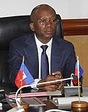
- Acting prime minister of Haiti Ariel Henry resigns, and is replaced by Michel Patrick Boisvert (pictured) while the Transitional Presidential Council is sworn in.
- The Ownership, Unity and Responsibility Party, led by Prime Minister Manasseh Sogavare, wins the most seats in the Solomon Islands general election but falls short of a majority.
- NASA announces that the Voyager 1 space probe is sending readable data for the first time in five months.
- The HDZ-led coalition wins the most seats in the Croatian parliamentary election but falls short of a majority.
- Ichthyotitan, the largest known marine reptile, is formally described.
On this day
May 2: National Day of Prayer in the United States (2024); Flag Day in Poland
- 1559 – Presbyterian clergyman John Knox returned from exile to lead the Scottish Reformation.
- 1889 – The Treaty of Wuchale was signed, ending the Italo-Ethiopian War, but differences in translation later led to another war.
- 1964 – Vietnam War: An explosion caused by Viet Cong commandos led USNS Card to sink in the port of Saigon.
- 1999 – Mireya Moscoso (pictured) became the first woman to be elected President of Panama.
- 2014 – Two mudslides in Badakhshan Province, Afghanistan, killed at least 350 people.
- Marutha of Tikrit ( d. 649)
- Mary Moser ( d. 1819)
- Giacomo Meyerbeer ( d. 1864)
- Engelbert Humperdinck ( b. 1936)
John Rocque's maps of London were published in 1746. A French-born British surveyor and cartographer,
John Rocque produced two maps of
London and the surrounding area. The better known of these, depicted here, is a 24-sheet map of the
City of London and the surrounding area, surveyed by Rocque and engraved by
John Pine and titled A Plan of the Cities of London and Westminster, and Borough of Southwark. Rocque combined two surveying techniques: he made a ground-level survey with a compass and a physical metal chain – the unit of length also being the
chain.
Compass bearings were taken of the lines measured. He also created a
triangulation network over the entire area to be covered by taking readings from church towers and similar high places using a
theodolite made by
Jonathan Sisson (the inventor of the telescopic-sighted theodolite) to measure the observed angle between two other prominent locations. The process was repeated from point to point. This image depicts all 24 sheets of Rocque's map.Map credit:
John Rocque and
John Pine


