Photos • Location

Cap Carbon Lighthouse

Cap Caxine Lighthouse
Cap Ivi Lighthouse

Fort Joinville Lighthouse in
Cherchell

Ilot d'Arzew Lighthouse
Ras Afia Lighthouse (Grande Phare de Jijel)


Test Inactive
| Name | Image | Location Coordinates |
County | Waterbody | Built | Inactive since |
Notes |
|---|---|---|---|---|---|---|---|
| Ballycurrin |
 |
Headford 53°29′06″N 9°12′47″W / 53.4851°N 9.2130°W |
Mayo | Lough Corrib | 1847 | Unknown | Unusual lakeshore light with external staircase. [1] |
| Blackrock Castle |
.jpg) |
Cork 51°54′00″N 8°24′09″W / 51.9000°N 8.4025°W |
Cork | Cork Harbour | 1582 | 1903 | A light was shown from a window in the highest tower. [2] |
| Calf Rock |
.jpg) |
Dursey Island 51°35′06″N 10°16′35″W / 51.5850°N 10.2763°W |
Cork | North Atlantic | 1866 | 1881 | The tower was badly damaged by a storm in 1881. [2] |
| Cape Clear |
.jpg) |
Cape Clear Island 51°26′04″N 9°29′05″W / 51.4345°N 9.4846°W |
Cork | Celtic Sea | 1818 | 1854 | Deactivated after the original Fastnet lighthouse was completed. [2] |
| Clare Island |
.jpg) |
Clare Island 53°49′39″N 9°59′00″W / 53.8275°N 9.9834°W |
Mayo | Clew Bay | 1818 | 1965 | Refurbished as a guest house. [1] |
| Culmore Point |
.jpg) |
Culmore 55°02′47″N 7°15′15″W / 55.0464°N 7.2541°W |
Londonderry | River Foyle | 1920s | 2012 | White and green tower next to Culmore Fort. Replaced by a post light. [3] |
| Drogheda East |
 |
Mornington 53°43′09″N 6°14′51″W / 53.7192°N 6.2476°W |
Meath | River Boyne | 1880s | 2007 | One of three lights constructed to aid navigation along the Boyne and into the harbour at Drogheda. [4] |
| Drogheda North |
Mornington 53°43′27″N 6°15′16″W / 53.7241°N 6.2544°W |
Meath | River Boyne | 1880s | 2000 | One of three lights constructed to aid navigation along the Boyne and into the harbour at Drogheda. [4] | |
| Drogheda West |
Mornington 53°43′08″N 6°14′56″W / 53.7189°N 6.2489°W |
Meath | River Boyne | 1880s | 2000 | One of three lights constructed to aid navigation along the Boyne and into the harbour at Drogheda. [4] | |
| Ferris Point |
 |
Larne 54°51′05″N 5°47′24″W / 54.8514°N 5.7900°W |
Antrim | Larne Lough | Unknown | 1994 | Now houses the control room for the Port of Larne. [3] |
| Greenore |
 |
Greenore 54°02′01″N 6°07′56″W / 54.0337°N 6.1322°W |
Louth | Carlingford Lough | 1830 | 1986 | Located on Carlingford Lough next to Greenore Port. [4] |
| Howth Harbour |
 |
Howth 53°23′36″N 6°04′00″W / 53.3933°N 6.0668°W |
Fingal | Irish Sea | 1818 | 1982 | Replaced by modern light nearby. [4] |
| Inishmore |
 |
Inishmore 53°07′39″N 9°42′08″W / 53.1274°N 9.7022°W |
Galway | Galway Bay | 1818 | 1857 | The first lighthouse in the Aran Islands, built on the highest point of Inishmore. [1] |
| Inishowen East |
 |
Inishowen 55°13′36″N 6°55′38″W / 55.2266°N 6.9271°W |
Donegal | North Channel | 1837 | 1961 | Squat tower separate from the active West Inishowen Lighthouse. [1] |
| Kilcredaun Head |
 |
Carrigaholt 52°34′47″N 9°42′35″W / 52.5798°N 9.7097°W |
Clare | Shannon Estuary | 1824 | 2011 | Positioned on a headland on the northern shore of the estuary. [2] |
| Mutton Island |
_(26324379932).jpg) |
Mutton Island 53°15′15″N 9°03′13″W / 53.2541°N 9.0535°W |
Galway | Galway Bay | 1817 | 1977 | Replaced by the Galway Harbour lighthouse. Restored between 2005 and 2011. [1] |
| Skelling Michael (High) |
Skelling Michael 51°46′13″N 10°32′38″W / 51.7702°N 10.5438°W |
Kerry | North Atlantic | 1826 | 1870 | Built on a high ledge on the western flank of Skelling Michael. [2] | |
| South Rock (Kilwarlin) |
|
Kearney 54°24′11″N 5°23′00″W / 54.4030°N 5.3833°W |
Down | North Channel | 1797 | 1877 | Considered to be the "oldest surviving waveswept lighthouse in Ireland". [3] |
| West Maidens |
 |
The Maidens 54°59′45″N 5°42′49″W / 54.9957°N 5.7136°W |
Antrim | North Channel | 1829 | 1903 | Built at the same time as the East Maidens light. [3] |
| Wicklow Head High (1781) |
 |
Wicklow Head 52°57′55″N 6°00′09″W / 52.9652°N 6.0025°W |
Wicklow | St George's Channel | 1781 | 1818 | Octagonal tower, renovated as a holiday let by the Irish Landmark Trust in 1996. [4] |
| Wicklow Head High (1818) |
 |
Wicklow Head 52°57′56″N 6°00′02″W / 52.9655°N 6.0005°W |
Wicklow | St George's Channel | 1818 | 1865 | Round tower, built to complement the currently active low level light. [4] |
Test Other

.JPG)

.jpg)


.jpg)
.jpg)


_(33020734955).jpg)


Test


_(2).jpg)


_(3).jpg)


Test2
Test IoM
| Name | Image | Location Coordinates |
Built | Tower Height | Focal Height | Range | Notes |
|---|---|---|---|---|---|---|---|
| Calf of Man (low) Lighthouse |
 |
Calf of Man 54°03.157′N 4°49.734′W / 54.052617°N 4.828900°W |
1815 | 15 m (49 ft) | 86 m (282 ft) | Inactive | Designed by Robert Stevenson. Inactive since 1875 |
| Calf of Man (high) Lighthouse |
 |
Calf of Man 54°03.180′N 4°49.715′W / 54.053000°N 4.828583°W |
1815/1968 | 18 m (59 ft) | 93 m (305 ft) | Inactive | Designed by Robert Stevenson. Inactive since 2007 |
| Castletown Harbour: Irish Quay Light |
 |
Castletown 54°04′21″N 4°39′00″W / 54.0724°N 4.6499°W |
1944 | 3.5 m (11 ft) | 5 m (16 ft) | 5 nmi (9 km) | Operated by Isle of Man Harbours |
| Castletown Harbour: New Pier Light |
 |
Castletown 54°04′21″N 4°39′00″W / 54.0724°N 4.6499°W |
1849 | 7 m (23 ft) | 8 m (26 ft) | 5 nmi (9 km) | Operated by Isle of Man Harbours |
| Chicken Rock Lighthouse |
 |
Chicken Rock 54°02.271′N 4°50.315′W / 54.037850°N 4.838583°W |
1875 | 44 m (144 ft) | 38 m (125 ft) | 21 nmi (39 km) | Designed by David & Thomas Stevenson |
| Douglas Head Lighthouse |
 |
Douglas Head 54°08.599′N 4°27.947′W / 54.143317°N 4.465783°W |
1857 | 20 m (66 ft) | 32 m (105 ft) | 24 nmi (44 km) | Designed by David & Thomas Stevenson |
| Langness Lighthouse |
 |
Dreswick Point 54°03′14″N 4°37′30″W / 54.05389°N 4.62500°W |
1880 | 19 m (62 ft) | 23 m (75 ft) | 12 nmi (22 km) | Designed by David & Thomas Stevenson |
| Maughold Head Lighthouse |
 |
Maughold Head 54°17.734′N 4°18.585′W / 54.295567°N 4.309750°W |
1914 | 23 m (75 ft) | 65 m (213 ft) | 21 nmi (39 km) | Designed by Charles Stevenson |
| Point of Ayre Lighthouse |
 |
Point of Ayre 54°24.959′N 4°22.111′W / 54.415983°N 4.368517°W |
1818 | 30 m (98 ft) | 32 m (105 ft) | 19 nmi (35 km) | Designed by Robert Stevenson |
| Point of Ayre Winkie Light |
 |
Point of Ayre 54°24.959′N 4°22.111′W / 54.415983°N 4.368517°W |
1888 | 10 m (33 ft) | 10 m (33 ft) | Inactive | Inactive since 2010 |
| Port Erin Range Front Light |
 |
Port Erin 54°05′14″N 4°45′34″W / 54.0872°N 4.7594°W |
Unknown | 11 m (36 ft) | 10 m (33 ft) | 5 nmi (9 km) | Operated by Isle of Man Harbours |
| Thousla Rock Light |
 |
Calf Sound 54°03′44″N 4°48′02″W / 54.06215°N 4.80065°W |
1981 | 9 m (30 ft) | 9 m (30 ft) | 4 nmi (7 km) | Octagonal pillar, displays a flashing red light. |
Table S
.jpg)


.JPG)


.jpg)


_-_geograph.org.uk_-_1532519.jpg)


Test scot
| Lighthouse | Image | Area Coordinates |
Island/ mainland | Opened | Built by | Operated by/closed | Height tower | Elev- ation |
|---|---|---|---|---|---|---|---|---|
| Ailsa Craig Lighthouse |
 |
Ayrshire 55°15.126′N 5°06.523′W / 55.252100°N 5.108717°W |
mainland | 1886 | Thomas & David A Stevenson | NLB | 11m | 18m |
| Ardnamurchan Lighthouse |
 |
Highland 56°43.630′N 6°13.567′W / 56.727167°N 6.226117°W |
mainland | 1849 | Alan Stevenson | NLB | 35m | 55m |
| Auskerry |
 |
Orkney Islands 59°01.557′N 2°34.367′W / 59.025950°N 2.572783°W |
Auskerry | 1867 | David & Thomas Stevenson | NLB | 34m | 34m |
| Barns Ness Lighthouse |
 |
Lothian,
Fife and
Borders 55°59.2′N 2°26.6′W / 55.9867°N 2.4433°W |
mainland | 1901 | David A Stevenson | 2005 | 37m | 36m |
| Barra Head Lighthouse |
 |
Western Isles 56°47.128′N 7°39.220′W / 56.785467°N 7.653667°W |
Barra Head | 1833 | Robert Stevenson | NLB | 18m | 208m |
| Name | Image | Location Coordinates |
Waterbody | Built | Tower Height | Focal Height | Range | Admiralty Number |
|---|---|---|---|---|---|---|---|---|
| Cabo Bojador Lighthouse |
 |
Cape Bojador 26°07′26″N 14°29′10″W / 26.1239°N 14.4861°W |
Atlantic | Unknown | 45 m (148 ft) | 70 m (230 ft) | 24 nmi (44 km) | D2628 |
| Cap des Trois Fourches Lighthouse |
 |
Cape Three Forks 35°26′18″N 2°57′48″W / 35.4383°N 2.9633°W |
Mediterranean | 1909 | 18 m (59 ft) | 112 m (367 ft) | 19 nmi (35 km) | E6778 |
| Cap Rhir Lighthouse |
 |
Tamri 30°38′00″N 9°53′00″W / 30.6333°N 9.8833°W |
Atlantic | 1931 | 42 m (138 ft) | 85 m (279 ft) | 22 nmi (41 km) | D2608 |
| Cap Spartel Lighthouse |
 |
Cap Spartel 35°47′30″N 5°55′18″W / 35.7917°N 5.9217°W |
Atlantic | 1864 | 24 m (79 ft) | 91 m (299 ft) | 30 nmi (56 km) | D2510 |
| El Cabino Lighthouse |
.jpg) |
NE of
Cape Bojador 26°25′34″N 14°10′49″W / 26.426°N 14.1802°W |
Atlantic | Unknown | 32 m (105 ft) | 37 m (121 ft) | 9 nmi (17 km) | D2626 |
| El Hank Lighthouse |
 |
Casablanca 33°36′42″N 7°39′24″W / 33.6117°N 7.6567°W |
Atlantic | 1919 | 49 m (161 ft) | 65 m (213 ft) | 30 nmi (56 km) | D2574 |
| Pointe Malabato Lighthouse |
 |
Cape Malabata 35°49′00″N 5°44′54″W / 35.8167°N 5.7483°W |
Atlantic | Unknown | 18 m (59 ft) | 76 m (249 ft) | 22 nmi (41 km) | D2498 |
| Rabat Lighthouse |
 |
Rabat 34°02′06″N 6°50′48″W / 34.035°N 6.8467°W |
Atlantic | 1920 | 24 m (79 ft) | 31 m (102 ft) | 16 nmi (30 km) | D2554 |
| Sidi Bou Afi Lighthouse |
 |
El Jadida 33°15′00″N 8°31′00″W / 33.25°N 8.5167°W |
Atlantic | 1916 | 46 m (151 ft) | 65 m (213 ft) | 30 nmi (56 km) | D2588 |
Table 2


.jpg)

Table3
| Name | Image | Location Coordinates |
Built | Tower Height | Focal Height | Notes |
|---|---|---|---|---|---|---|
| Delimera Lighthouse |

|
Marsaxlokk, Malta | 1854 | 9 nmi (17 km) | 46 m (151 ft) | Now deactivated, renovated |
| Delimera Lighthouse (New) |

|
Marsaxlokk, Malta | 1990 | 18 m (59 ft) | 35 m (115 ft) | Modern lighthouse built to replace historic light |
| Fort St. Elmo Light |

|
Fort Saint Elmo,
Malta |
1976 | 10 m (33 ft) | 49 m (161 ft) | Skeleton tower above the fort |
| Giordan Lighthouse |

|
Ghasri , Gozo | 1853 | 22 m (72 ft) | 180 m (591 ft) | |
| Ricasoli Breakwater Lighthouse |
_04_ies.jpg)
|
Grand Harbour,
Malta |
1908 | 9 m (30 ft) | 11 m (36 ft) | Masonry tower with red lantern |
| St. Elmo Breakwater Lighthouse |
_(2).jpg)
|
Grand Harbour,
Malta |
1908 | 14 m (46 ft) | 16 m (52 ft) | Masonry tower with green lantern |
| Mgarr Main Breakwater Light |
_11_ies.jpg)
|
Mgarr, Gozo,
Gozo |
1970s | 5 m (16 ft) | 8 m (26 ft) | Conical tower painted red and white |
| Mgarr North Breakwater Light |
_02_ies.jpg)
|
Mgarr, Gozo,
Gozo |
1970s | 5 m (16 ft) | 7 m (23 ft) | Conical tower painted green and white |
| Portomaso Lighthouse |

|
St. Julians,
Malta |
1990s | 6 m (20 ft) | 8 m (26 ft) | Modern design, part of new marina |
Table3
| Name | Image | Location Coordinates |
Admiralty Number |
Tower Height | Range |
|---|---|---|---|---|---|
| Bugle Caye Light | Bugle Caye 16°29′16″N 88°19′25″W / 16.48790°N 88.32369°W |
J5968 | 19 m (62 ft) | 10 nmi (19 km) | |
| East Snake Caye Light | East Snake Caye 16°12′31″N 88°30′31″W / 16.20849°N 88.50873°W |
J5972 | 20 m (66 ft) | 13 nmi (24 km) | |
| English Caye Light |
 |
English Caye 17°19′38″N 88°02′56″W / 17.32721°N 88.04883°W |
J5943.1 | 19 m (62 ft) | 11 nmi (20 km) |
| Fort George(Baron Bliss) |
 |
Belize City 17°29′29″N 88°10′53″W / 17.49144°N 88.18147°W |
J5954 | 15 m (49 ft) | 8 nmi (15 km) |
| Half Moon Caye Light |
 |
Half Moon Caye 17°12′11″N 87°32′08″W / 17.20303°N 87.53559°W |
J5936 | 24 m (79 ft) | 14 nmi (26 km) |
| Hunting Caye Light | Hunting Caye 16°06′30″N 88°16′06″W / 16.10822°N 88.26829°W |
J5974 | 17 m (56 ft) | 13 nmi (24 km) | |
| Mauger Caye Light |
.jpg) |
Turneffe Atoll 17°36′26″N 87°46′21″W / 17.60723°N 87.77242°W |
J5940 | 19 m (62 ft) | 13 nmi (24 km) |
| Sandbore Caye Light |
Sandbore Caye 17°27′51″N 87°29′18″W / 17.46429°N 87.48822°W |
J5934 | 25 m (82 ft) | 17 nmi (31 km) |
Table4


Table6
| Name | Image | Location Coordinates |
Built | Tower Height | Focal Height | Range | Admiralty Number |
|---|---|---|---|---|---|---|---|
| Abrolhos Lighthouse | 17°57′54″S 38°41′30″W / 17.965°S 38.6917°W | 1861 | 22 m (72 ft) | 60 m (197 ft) | 51 nmi (94 km) | G0306 | |
| Albardao Lighthouse | 33°12′12″S 52°42′30″W / 33.2033°S 52.7083°W | 1948 | 44 m (144 ft) | 50 m (164 ft) | 42 nmi (78 km) | G0640 |
Table 7
| Name | Image | Location Coordinates |
Built | Tower Height | Focal Height | Range | NGA Number |
|---|---|---|---|---|---|---|---|
| Cap Bon Lighthouse |
 |
Cap Bon 37°04′42″N 11°02′42″E / 37.0783°N 11.045°E |
1875 | 20 m (66 ft) | 126 m (413 ft) | 30 nmi (56 km) | 21984 |
| Cap Serrat Lighthouse |
 |
Cap Serrat,
Bizerte 37°13′54″N 9°12′36″E / 37.2317°N 9.21°E |
1890 | 13 m (43 ft) | 199 m (653 ft) | 24 nmi (44 km) | 22136 |
| Gabès |
 |
Gabès 33°53′36″N 10°06′48″E / 33.8933°N 10.1133°E |
1893 | 11 m (36 ft) | 13 m (43 ft) | 20 nmi (37 km) | 21820 |
| Galiton de l'Ouest |
Galite Islands 37°29′54″N 8°52′36″E / 37.4983°N 8.8767°E |
1920 | 14 m (46 ft) | 168 m (551 ft) | 24 nmi (44 km) | 22144 | |
| Hammamet Lighthouse |
 |
Hammamet 36°23′42″N 10°36′54″E / 36.395°N 10.615°E |
1912 | 14 m (46 ft) | 17 m (56 ft) | 15 nmi (28 km) | 21976 |
| Ile Kuriat Lighthouse |
 |
Kuriat,
Monastir 35°47′54″N 11°02′00″E / 35.7983°N 11.0333°E |
1894 | 26 m (85 ft) | 30 m (98 ft) | 18 nmi (33 km) | 21920 |
| Ile Plane Lighthouse |
 |
Ile Plane,
Ghar al Milh 37°10′54″N 10°19′42″E / 37.1817°N 10.3283°E |
1888 | 12 m (39 ft) | 20 m (66 ft) | 15 nmi (28 km) | 22056 |
| Iles Cani Lighthouse |
 |
Gran Ile Cani,
Cap Zebib 37°21′24″N 10°07′24″E / 37.3567°N 10.1233°E |
1860 | 21 m (69 ft) | 39 m (128 ft) | 19 nmi (35 km) | 22064 |
| Kelibia Lighthouse |
 |
Kelibia 36°50′12″N 11°07′00″E / 36.8367°N 11.1167°E |
1888 | 18 m (59 ft) | 82 m (269 ft) | 23 nmi (43 km) | 21980 |
| Mahdia Lighthouse |
.jpg) |
Mahdia 35°30′30″N 11°04′54″E / 35.5083°N 11.0817°E |
1890 | 15 m (49 ft) | 26 m (85 ft) | 17 nmi (31 km) | 21904 |
| Ras Enghela Lighthouse |
 |
Cape Angela 37°20′42″N 9°44′18″E / 37.345°N 9.7383°E |
1890 | 15 m (49 ft) | 38 m (125 ft) | 28 nmi (52 km) | 22132 |
| Ras Kaboudia Lighthouse |
Chebba 35°14′00″N 11°09′24″E / 35.2333°N 11.1567°E |
Unknown | 18 m (59 ft) | 28 m (92 ft) | 19 nmi (35 km) | 21900 | |
| Ras Taguerness Lighthouse |
 |
Djerba 33°49′18″N 11°02′42″E / 33.8217°N 11.045°E |
1895 | 49 m (161 ft) | 64 m (210 ft) | 24 nmi (44 km) | 21764 |
| Ras Thyna Lighthouse |
 |
Thyna 34°39′00″N 10°41′06″E / 34.65°N 10.685°E |
1895 | 44 m (144 ft) | 55 m (180 ft) | 24 nmi (44 km) | 21836 |
| Sidi Bou Said Lighthouse |
 |
Sidi Bou Said 36°52′18″N 10°20′54″E / 36.8717°N 10.3483°E |
1840 | 12 m (39 ft) | 146 m (479 ft) | 22 nmi (41 km) | 22040 |
| Sousse Lighthouse |
 |
Sousse 35°49′24″N 10°38′18″E / 35.8233°N 10.6383°E |
1890 | 22 m (72 ft) | 70 m (230 ft) | 22 nmi (41 km) | 21956 |
| Tabarka Lighthouse |
 |
Tabarka 36°57′48″N 8°45′30″E / 36.9633°N 8.7583°E |
1906 | 14 m (46 ft) | 72 m (236 ft) | 17 nmi (31 km) | 22148 |
Table 8

_-_%D9%85%D9%86%D8%A7%D8%B1%D8%A9_%D8%A7%D9%84%D8%AD%D9%85%D8%A7%D9%85%D8%A7%D8%AA.jpg)


_05.JPG)
| Name | Location Coordinates |
Built | Tower Height | Focal Height | Range | NGA Number |
|---|---|---|---|---|---|---|
| Cap Bengut Lighthouse |
Dellys 36°55′12″N 3°53′30″E / 36.92°N 3.8917°E |
2010 | 29 m (95 ft) | 63 m (207 ft) | 30 nmi (56 km) | 22360 |
| Cap Bougaroun Lighthouse |
Skikda Province 37°05′N 6°28′E / 37.09°N 6.47°E |
Unknown | 10 m (33 ft) | 91 m (299 ft) | 29 nmi (54 km) | 22284 |
| Cap Carbon Lighthouse |
Béjaïa 36°46′36″N 5°06′18″E / 36.7767°N 5.105°E |
1851 | 10 m (33 ft) | 220 m (722 ft) | 28 nmi (52 km) | 22328 |
| Cap Caxine Lighthouse |
Aïn Bénian 36°48′42″N 2°57′24″E / 36.8117°N 2.9567°E |
1868 | 33 m (108 ft) | 64 m (210 ft) | 30 nmi (56 km) | 22424 |
| Cap de Fer Lighthouse |
Skikda Province 37°04′54″N 7°10′24″E / 37.0817°N 7.1733°E |
1859 | 17 m (56 ft) | 65 m (213 ft) | 19 nmi (35 km) | 22228 |
| Cap de Garde Lighthouse |
Annaba 36°58′06″N 7°47′06″E / 36.9683°N 7.785°E |
1884 | 14 m (46 ft) | 143 m (469 ft) | 30 nmi (56 km) | 22208 |
| Cap de l'Aiguille Lighthouse |
Oran 35°52′36″N 0°29′24″W / 35.8767°N 0.49°W |
1906 | 10 m (33 ft) | 62 m (203 ft) | 26 nmi (48 km) | 22580 |
| Cap Falcon Lighthouse |
Oran 35°46′18″N 0°47′54″W / 35.7717°N 0.7983°W |
1868 | 27 m (89 ft) | 104 m (341 ft) | 31 nmi (57 km) | 22672 |
| Cap Ivi Lighthouse |
Mostaganem Province 36°06′54″N 0°13′42″E / 36.115°N 0.2283°E |
1898 | 18 m (59 ft) | 118 m (387 ft) | 31 nmi (57 km) | 22520 |
| Cap Matifou Lighthouse |
Aïn Taya 36°48′42″N 3°14′48″E / 36.8117°N 3.2467°E |
1868 | 6 m (20 ft) | 74 m (243 ft) | 23 nmi (43 km) | 22368 |
| Cap Sigli Lighthouse |
Béjaïa Province 36°53′30″N 4°45′12″E / 36.8917°N 4.7533°E |
1906 | 25 m (82 ft) | 57 m (187 ft) | 17 nmi (31 km) | 22336 |
| Cap Tenes Lighthouse |
Ténès 36°33′00″N 1°20′30″E / 36.55°N 1.3417°E |
1865 | 31 m (102 ft) | 89 m (292 ft) | 31 nmi (57 km) | 22488 |
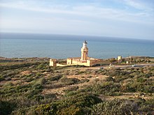
| Fort Joinville Lighthouse |
Cherchell 36°36′42″N 2°11′24″E / 36.6117°N 2.19°E |
1855 | 26 m (85 ft) | 37 m (121 ft) | 21 nmi (39 km) | 22468 |
| Ghazaouet - Nemours Lighthouse |
Ghazaouet 35°05′54″N 1°52′18″W / 35.0983°N 1.8717°W |
Unknown | 15 m (49 ft) | 93 m (305 ft) | 26 nmi (48 km) | 22700 |
| Ile Rachgoun Lighthouse |
Béni Saf 35°19′30″N 1°28′42″W / 35.325°N 1.4783°W |
1870 | 15 m (49 ft) | 81 m (266 ft) | 16 nmi (30 km) | 22696 |
| Ile Sridina Lighthouse |
Skikda Province 36°56′18″N 6°53′12″E / 36.9383°N 6.8867°E |
1906 | 12 m (39 ft) | 54 m (177 ft) | 20 nmi (37 km) | 22272 |
| Iles Habibas Lighthouse |
Habibas Islands 35°43′18″N 1°07′54″W / 35.7217°N 1.1317°W |
1879 | 12 m (39 ft) | 112 m (367 ft) | 26 nmi (48 km) | 22684 |
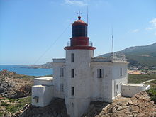
| Ilot d'Arzew Lighthouse |
Oran 35°52′24″N 0°17′24″W / 35.8733°N 0.29°W |
1848 | 12 m (39 ft) | 19 m (62 ft) | 16 nmi (30 km) | 22540 |
| Jetee du Large Lighthouse |
Oran 35°43′12″N 0°37′36″W / 35.72°N 0.6267°W |
1905 | 15 m (49 ft) | 21 m (69 ft) | 22 nmi (41 km) | 22584 |
| Passe Nord Lighthouse |
Algiers 36°46′36″N 3°04′42″E / 36.7767°N 3.0783°E |
Unknown | 17 m (56 ft) | 23 m (75 ft) | 20 nmi (37 km) | 22380 |
| Pointe Colombi Lighthouse |
El Marsa, Chlef 36°26′42″N 0°56′30″E / 36.445°N 0.9417°E |
Unknown | 29 m (95 ft) | 60 m (197 ft) | 26 nmi (48 km) | 22512 |
| Pointe de Dellys Lighthouse |
Dellys 36°55′24″N 3°55′24″E / 36.9233°N 3.9233°E |
2007 | 15 m (49 ft) | 41 m (135 ft) | 15 nmi (28 km) | 22348 |
| Ras Afia Lighthouse |
Jijel 36°49′12″N 5°41′30″E / 36.82°N 5.6917°E |
1871 | 14 m (46 ft) | 43 m (141 ft) | 24 nmi (44 km) | 22308 |
| Sidi Fredj Lighthouse |
Sidi Fredj 36°46′00″N 2°50′54″E / 36.7667°N 2.8483°E |
1970s | 24 m (79 ft) | 42 m (138 ft) | 17 nmi (31 km) | 22432 |
Table Test
| Name | Location | Co-ordinates | Image | Built | Tower Height m |
Focal Height | light | Notes | ||
|---|---|---|---|---|---|---|---|---|---|---|
| m | ft | m | ft | |||||||
| Formentor Lighthouse | Mallorca | 28°34′53″N 16°08′24″W / 28.58132°N 16.14003°W |

|
1863 | 24.55 | 80.5 | 24.55 | 80.5 | Fl(4)W.20s | |
| Far de la Punta de l'Avançada | Mallorca | 39°53′59″N 3°06′38″E / 39.89985°N 3.11064°E | 1905 | 27 | 89 | 290 | 950 | Oc(2)W.8s | ||
| Far d'Alcanada | Mallorca | 39°50′07″N 3°10′16″E / 39.83541°N 3.17117°E |

|
1861 | 5 | 16 | 19 | 62 | Fl.W.5s | |
Infobox
 | |
|
| |
| Location | Mazatlán, Mexico |
|---|---|
| Coordinates | 23°10′43″N 106°25′39″W / 23.1785°N 106.4275°W |
| Tower | |
| Constructed | 1879 |
| Foundation | single storey base |
| Construction | masonry |
| Height | 11 metres (36 ft) |
| Shape | square tower |
| Light | |
| Focal height | 157 metres (515 ft) |
| Lens | second order Fresnel lens
|
| Range | 33 nautical miles (61 km; 38 mi) |
| Characteristic | Fl.W. 7s |
The Mazatlán Lighthouse ( Spanish: Faro de Mazatlán) is an active lighthouse in Mazatlán, Mexico. It is located on the Isla Creston, a former rocky island at the southern end of the city to which is now joined by a causeway. [5] walk [6] Details [7]
Templates
Lighthouses and lightvessels in Europe | |
|---|---|
| Sovereign states |
|
Dependencies and other territories | |
List of lighthouses in Central America | ||
|---|---|---|
| Sovereign states | ||
| Caribbean |  | |
|---|---|---|
| Central America | ||
| Middle America | ||
| South America | ||
Dependencies not included. Semi-autonomous territories are in italics. | ||
- ^
a
b
c
d
e Cite error: The named reference
westwas invoked but never defined (see the help page). - ^
a
b
c
d
e Cite error: The named reference
southwestwas invoked but never defined (see the help page). - ^
a
b
c
d Cite error: The named reference
northwas invoked but never defined (see the help page). - ^
a
b
c
d
e
f
g Cite error: The named reference
eastwas invoked but never defined (see the help page). - ^ Rowlett, Russ. "Lighthouses of Mexico: Northwest Coast". The Lighthouse Directory. University of North Carolina at Chapel Hill. Retrieved 15 November 2014.
- ^ Izabella Gawin (3 July 2012). Lanzarote MARCO POLO Travel Guide E-book. Mair Dumont Marco Polo. pp. 71–. ISBN 978-3-8297-8016-2.
- ^ "El Faro Lighthouse in Mazatlán - The tallest lighthouse in the Americas!". mazatlantoday.net.
Test Inactive
| Name | Image | Location Coordinates |
County | Waterbody | Built | Inactive since |
Notes |
|---|---|---|---|---|---|---|---|
| Ballycurrin |
|
Headford 53°29′06″N 9°12′47″W / 53.4851°N 9.2130°W |
Mayo | Lough Corrib | 1847 | Unknown | Unusual lakeshore light with external staircase. [1] |
| Blackrock Castle |
|
Cork 51°54′00″N 8°24′09″W / 51.9000°N 8.4025°W |
Cork | Cork Harbour | 1582 | 1903 | A light was shown from a window in the highest tower. [2] |
| Calf Rock |
|
Dursey Island 51°35′06″N 10°16′35″W / 51.5850°N 10.2763°W |
Cork | North Atlantic | 1866 | 1881 | The tower was badly damaged by a storm in 1881. [2] |
| Cape Clear |
|
Cape Clear Island 51°26′04″N 9°29′05″W / 51.4345°N 9.4846°W |
Cork | Celtic Sea | 1818 | 1854 | Deactivated after the original Fastnet lighthouse was completed. [2] |
| Clare Island |
|
Clare Island 53°49′39″N 9°59′00″W / 53.8275°N 9.9834°W |
Mayo | Clew Bay | 1818 | 1965 | Refurbished as a guest house. [1] |
| Culmore Point |
|
Culmore 55°02′47″N 7°15′15″W / 55.0464°N 7.2541°W |
Londonderry | River Foyle | 1920s | 2012 | White and green tower next to Culmore Fort. Replaced by a post light. [3] |
| Drogheda East |
|
Mornington 53°43′09″N 6°14′51″W / 53.7192°N 6.2476°W |
Meath | River Boyne | 1880s | 2007 | One of three lights constructed to aid navigation along the Boyne and into the harbour at Drogheda. [4] |
| Drogheda North |
Mornington 53°43′27″N 6°15′16″W / 53.7241°N 6.2544°W |
Meath | River Boyne | 1880s | 2000 | One of three lights constructed to aid navigation along the Boyne and into the harbour at Drogheda. [4] | |
| Drogheda West |
Mornington 53°43′08″N 6°14′56″W / 53.7189°N 6.2489°W |
Meath | River Boyne | 1880s | 2000 | One of three lights constructed to aid navigation along the Boyne and into the harbour at Drogheda. [4] | |
| Ferris Point |
|
Larne 54°51′05″N 5°47′24″W / 54.8514°N 5.7900°W |
Antrim | Larne Lough | Unknown | 1994 | Now houses the control room for the Port of Larne. [3] |
| Greenore |
|
Greenore 54°02′01″N 6°07′56″W / 54.0337°N 6.1322°W |
Louth | Carlingford Lough | 1830 | 1986 | Located on Carlingford Lough next to Greenore Port. [4] |
| Howth Harbour |
|
Howth 53°23′36″N 6°04′00″W / 53.3933°N 6.0668°W |
Fingal | Irish Sea | 1818 | 1982 | Replaced by modern light nearby. [4] |
| Inishmore |
|
Inishmore 53°07′39″N 9°42′08″W / 53.1274°N 9.7022°W |
Galway | Galway Bay | 1818 | 1857 | The first lighthouse in the Aran Islands, built on the highest point of Inishmore. [1] |
| Inishowen East |
|
Inishowen 55°13′36″N 6°55′38″W / 55.2266°N 6.9271°W |
Donegal | North Channel | 1837 | 1961 | Squat tower separate from the active West Inishowen Lighthouse. [1] |
| Kilcredaun Head |
|
Carrigaholt 52°34′47″N 9°42′35″W / 52.5798°N 9.7097°W |
Clare | Shannon Estuary | 1824 | 2011 | Positioned on a headland on the northern shore of the estuary. [2] |
| Mutton Island |
|
Mutton Island 53°15′15″N 9°03′13″W / 53.2541°N 9.0535°W |
Galway | Galway Bay | 1817 | 1977 | Replaced by the Galway Harbour lighthouse. Restored between 2005 and 2011. [1] |
| Skelling Michael (High) |
Skelling Michael 51°46′13″N 10°32′38″W / 51.7702°N 10.5438°W |
Kerry | North Atlantic | 1826 | 1870 | Built on a high ledge on the western flank of Skelling Michael. [2] | |
| South Rock (Kilwarlin) |
|
Kearney 54°24′11″N 5°23′00″W / 54.4030°N 5.3833°W |
Down | North Channel | 1797 | 1877 | Considered to be the "oldest surviving waveswept lighthouse in Ireland". [3] |
| West Maidens |
|
The Maidens 54°59′45″N 5°42′49″W / 54.9957°N 5.7136°W |
Antrim | North Channel | 1829 | 1903 | Built at the same time as the East Maidens light. [3] |
| Wicklow Head High (1781) |
|
Wicklow Head 52°57′55″N 6°00′09″W / 52.9652°N 6.0025°W |
Wicklow | St George's Channel | 1781 | 1818 | Octagonal tower, renovated as a holiday let by the Irish Landmark Trust in 1996. [4] |
| Wicklow Head High (1818) |
|
Wicklow Head 52°57′56″N 6°00′02″W / 52.9655°N 6.0005°W |
Wicklow | St George's Channel | 1818 | 1865 | Round tower, built to complement the currently active low level light. [4] |
Test Other
Test
Test2
Test IoM
| Name | Image | Location Coordinates |
Built | Tower Height | Focal Height | Range | Notes |
|---|---|---|---|---|---|---|---|
| Calf of Man (low) Lighthouse |
|
Calf of Man 54°03.157′N 4°49.734′W / 54.052617°N 4.828900°W |
1815 | 15 m (49 ft) | 86 m (282 ft) | Inactive | Designed by Robert Stevenson. Inactive since 1875 |
| Calf of Man (high) Lighthouse |
|
Calf of Man 54°03.180′N 4°49.715′W / 54.053000°N 4.828583°W |
1815/1968 | 18 m (59 ft) | 93 m (305 ft) | Inactive | Designed by Robert Stevenson. Inactive since 2007 |
| Castletown Harbour: Irish Quay Light |
|
Castletown 54°04′21″N 4°39′00″W / 54.0724°N 4.6499°W |
1944 | 3.5 m (11 ft) | 5 m (16 ft) | 5 nmi (9 km) | Operated by Isle of Man Harbours |
| Castletown Harbour: New Pier Light |
|
Castletown 54°04′21″N 4°39′00″W / 54.0724°N 4.6499°W |
1849 | 7 m (23 ft) | 8 m (26 ft) | 5 nmi (9 km) | Operated by Isle of Man Harbours |
| Chicken Rock Lighthouse |
|
Chicken Rock 54°02.271′N 4°50.315′W / 54.037850°N 4.838583°W |
1875 | 44 m (144 ft) | 38 m (125 ft) | 21 nmi (39 km) | Designed by David & Thomas Stevenson |
| Douglas Head Lighthouse |
|
Douglas Head 54°08.599′N 4°27.947′W / 54.143317°N 4.465783°W |
1857 | 20 m (66 ft) | 32 m (105 ft) | 24 nmi (44 km) | Designed by David & Thomas Stevenson |
| Langness Lighthouse |
|
Dreswick Point 54°03′14″N 4°37′30″W / 54.05389°N 4.62500°W |
1880 | 19 m (62 ft) | 23 m (75 ft) | 12 nmi (22 km) | Designed by David & Thomas Stevenson |
| Maughold Head Lighthouse |
|
Maughold Head 54°17.734′N 4°18.585′W / 54.295567°N 4.309750°W |
1914 | 23 m (75 ft) | 65 m (213 ft) | 21 nmi (39 km) | Designed by Charles Stevenson |
| Point of Ayre Lighthouse |
|
Point of Ayre 54°24.959′N 4°22.111′W / 54.415983°N 4.368517°W |
1818 | 30 m (98 ft) | 32 m (105 ft) | 19 nmi (35 km) | Designed by Robert Stevenson |
| Point of Ayre Winkie Light |
|
Point of Ayre 54°24.959′N 4°22.111′W / 54.415983°N 4.368517°W |
1888 | 10 m (33 ft) | 10 m (33 ft) | Inactive | Inactive since 2010 |
| Port Erin Range Front Light |
|
Port Erin 54°05′14″N 4°45′34″W / 54.0872°N 4.7594°W |
Unknown | 11 m (36 ft) | 10 m (33 ft) | 5 nmi (9 km) | Operated by Isle of Man Harbours |
| Thousla Rock Light |
|
Calf Sound 54°03′44″N 4°48′02″W / 54.06215°N 4.80065°W |
1981 | 9 m (30 ft) | 9 m (30 ft) | 4 nmi (7 km) | Octagonal pillar, displays a flashing red light. |
Table S
Test scot
| Lighthouse | Image | Area Coordinates |
Island/ mainland | Opened | Built by | Operated by/closed | Height tower | Elev- ation |
|---|---|---|---|---|---|---|---|---|
| Ailsa Craig Lighthouse |
|
Ayrshire 55°15.126′N 5°06.523′W / 55.252100°N 5.108717°W |
mainland | 1886 | Thomas & David A Stevenson | NLB | 11m | 18m |
| Ardnamurchan Lighthouse |
|
Highland 56°43.630′N 6°13.567′W / 56.727167°N 6.226117°W |
mainland | 1849 | Alan Stevenson | NLB | 35m | 55m |
| Auskerry |
|
Orkney Islands 59°01.557′N 2°34.367′W / 59.025950°N 2.572783°W |
Auskerry | 1867 | David & Thomas Stevenson | NLB | 34m | 34m |
| Barns Ness Lighthouse |
|
Lothian,
Fife and
Borders 55°59.2′N 2°26.6′W / 55.9867°N 2.4433°W |
mainland | 1901 | David A Stevenson | 2005 | 37m | 36m |
| Barra Head Lighthouse |
|
Western Isles 56°47.128′N 7°39.220′W / 56.785467°N 7.653667°W |
Barra Head | 1833 | Robert Stevenson | NLB | 18m | 208m |
| Name | Image | Location Coordinates |
Waterbody | Built | Tower Height | Focal Height | Range | Admiralty Number |
|---|---|---|---|---|---|---|---|---|
| Cabo Bojador Lighthouse |
|
Cape Bojador 26°07′26″N 14°29′10″W / 26.1239°N 14.4861°W |
Atlantic | Unknown | 45 m (148 ft) | 70 m (230 ft) | 24 nmi (44 km) | D2628 |
| Cap des Trois Fourches Lighthouse |
|
Cape Three Forks 35°26′18″N 2°57′48″W / 35.4383°N 2.9633°W |
Mediterranean | 1909 | 18 m (59 ft) | 112 m (367 ft) | 19 nmi (35 km) | E6778 |
| Cap Rhir Lighthouse |
|
Tamri 30°38′00″N 9°53′00″W / 30.6333°N 9.8833°W |
Atlantic | 1931 | 42 m (138 ft) | 85 m (279 ft) | 22 nmi (41 km) | D2608 |
| Cap Spartel Lighthouse |
|
Cap Spartel 35°47′30″N 5°55′18″W / 35.7917°N 5.9217°W |
Atlantic | 1864 | 24 m (79 ft) | 91 m (299 ft) | 30 nmi (56 km) | D2510 |
| El Cabino Lighthouse |
|
NE of
Cape Bojador 26°25′34″N 14°10′49″W / 26.426°N 14.1802°W |
Atlantic | Unknown | 32 m (105 ft) | 37 m (121 ft) | 9 nmi (17 km) | D2626 |
| El Hank Lighthouse |
|
Casablanca 33°36′42″N 7°39′24″W / 33.6117°N 7.6567°W |
Atlantic | 1919 | 49 m (161 ft) | 65 m (213 ft) | 30 nmi (56 km) | D2574 |
| Pointe Malabato Lighthouse |
|
Cape Malabata 35°49′00″N 5°44′54″W / 35.8167°N 5.7483°W |
Atlantic | Unknown | 18 m (59 ft) | 76 m (249 ft) | 22 nmi (41 km) | D2498 |
| Rabat Lighthouse |
|
Rabat 34°02′06″N 6°50′48″W / 34.035°N 6.8467°W |
Atlantic | 1920 | 24 m (79 ft) | 31 m (102 ft) | 16 nmi (30 km) | D2554 |
| Sidi Bou Afi Lighthouse |
|
El Jadida 33°15′00″N 8°31′00″W / 33.25°N 8.5167°W |
Atlantic | 1916 | 46 m (151 ft) | 65 m (213 ft) | 30 nmi (56 km) | D2588 |
Table 2
Table3
| Name | Image | Location Coordinates |
Built | Tower Height | Focal Height | Notes |
|---|---|---|---|---|---|---|
| Delimera Lighthouse |
|
Marsaxlokk, Malta | 1854 | 9 nmi (17 km) | 46 m (151 ft) | Now deactivated, renovated |
| Delimera Lighthouse (New) |
|
Marsaxlokk, Malta | 1990 | 18 m (59 ft) | 35 m (115 ft) | Modern lighthouse built to replace historic light |
| Fort St. Elmo Light |
|
Fort Saint Elmo,
Malta |
1976 | 10 m (33 ft) | 49 m (161 ft) | Skeleton tower above the fort |
| Giordan Lighthouse |
|
Ghasri , Gozo | 1853 | 22 m (72 ft) | 180 m (591 ft) | |
| Ricasoli Breakwater Lighthouse |
|
Grand Harbour,
Malta |
1908 | 9 m (30 ft) | 11 m (36 ft) | Masonry tower with red lantern |
| St. Elmo Breakwater Lighthouse |
|
Grand Harbour,
Malta |
1908 | 14 m (46 ft) | 16 m (52 ft) | Masonry tower with green lantern |
| Mgarr Main Breakwater Light |
|
Mgarr, Gozo,
Gozo |
1970s | 5 m (16 ft) | 8 m (26 ft) | Conical tower painted red and white |
| Mgarr North Breakwater Light |
|
Mgarr, Gozo,
Gozo |
1970s | 5 m (16 ft) | 7 m (23 ft) | Conical tower painted green and white |
| Portomaso Lighthouse |
|
St. Julians,
Malta |
1990s | 6 m (20 ft) | 8 m (26 ft) | Modern design, part of new marina |
Table3
| Name | Image | Location Coordinates |
Admiralty Number |
Tower Height | Range |
|---|---|---|---|---|---|
| Bugle Caye Light | Bugle Caye 16°29′16″N 88°19′25″W / 16.48790°N 88.32369°W |
J5968 | 19 m (62 ft) | 10 nmi (19 km) | |
| East Snake Caye Light | East Snake Caye 16°12′31″N 88°30′31″W / 16.20849°N 88.50873°W |
J5972 | 20 m (66 ft) | 13 nmi (24 km) | |
| English Caye Light |
|
English Caye 17°19′38″N 88°02′56″W / 17.32721°N 88.04883°W |
J5943.1 | 19 m (62 ft) | 11 nmi (20 km) |
| Fort George(Baron Bliss) |
|
Belize City 17°29′29″N 88°10′53″W / 17.49144°N 88.18147°W |
J5954 | 15 m (49 ft) | 8 nmi (15 km) |
| Half Moon Caye Light |
|
Half Moon Caye 17°12′11″N 87°32′08″W / 17.20303°N 87.53559°W |
J5936 | 24 m (79 ft) | 14 nmi (26 km) |
| Hunting Caye Light | Hunting Caye 16°06′30″N 88°16′06″W / 16.10822°N 88.26829°W |
J5974 | 17 m (56 ft) | 13 nmi (24 km) | |
| Mauger Caye Light |
|
Turneffe Atoll 17°36′26″N 87°46′21″W / 17.60723°N 87.77242°W |
J5940 | 19 m (62 ft) | 13 nmi (24 km) |
| Sandbore Caye Light |
Sandbore Caye 17°27′51″N 87°29′18″W / 17.46429°N 87.48822°W |
J5934 | 25 m (82 ft) | 17 nmi (31 km) |
Table4
Table6
| Name | Image | Location Coordinates |
Built | Tower Height | Focal Height | Range | Admiralty Number |
|---|---|---|---|---|---|---|---|
| Abrolhos Lighthouse | 17°57′54″S 38°41′30″W / 17.965°S 38.6917°W | 1861 | 22 m (72 ft) | 60 m (197 ft) | 51 nmi (94 km) | G0306 | |
| Albardao Lighthouse | 33°12′12″S 52°42′30″W / 33.2033°S 52.7083°W | 1948 | 44 m (144 ft) | 50 m (164 ft) | 42 nmi (78 km) | G0640 |
Table 7
| Name | Image | Location Coordinates |
Built | Tower Height | Focal Height | Range | NGA Number |
|---|---|---|---|---|---|---|---|
| Cap Bon Lighthouse |
|
Cap Bon 37°04′42″N 11°02′42″E / 37.0783°N 11.045°E |
1875 | 20 m (66 ft) | 126 m (413 ft) | 30 nmi (56 km) | 21984 |
| Cap Serrat Lighthouse |
|
Cap Serrat,
Bizerte 37°13′54″N 9°12′36″E / 37.2317°N 9.21°E |
1890 | 13 m (43 ft) | 199 m (653 ft) | 24 nmi (44 km) | 22136 |
| Gabès |
|
Gabès 33°53′36″N 10°06′48″E / 33.8933°N 10.1133°E |
1893 | 11 m (36 ft) | 13 m (43 ft) | 20 nmi (37 km) | 21820 |
| Galiton de l'Ouest |
Galite Islands 37°29′54″N 8°52′36″E / 37.4983°N 8.8767°E |
1920 | 14 m (46 ft) | 168 m (551 ft) | 24 nmi (44 km) | 22144 | |
| Hammamet Lighthouse |
|
Hammamet 36°23′42″N 10°36′54″E / 36.395°N 10.615°E |
1912 | 14 m (46 ft) | 17 m (56 ft) | 15 nmi (28 km) | 21976 |
| Ile Kuriat Lighthouse |
|
Kuriat,
Monastir 35°47′54″N 11°02′00″E / 35.7983°N 11.0333°E |
1894 | 26 m (85 ft) | 30 m (98 ft) | 18 nmi (33 km) | 21920 |
| Ile Plane Lighthouse |
|
Ile Plane,
Ghar al Milh 37°10′54″N 10°19′42″E / 37.1817°N 10.3283°E |
1888 | 12 m (39 ft) | 20 m (66 ft) | 15 nmi (28 km) | 22056 |
| Iles Cani Lighthouse |
|
Gran Ile Cani,
Cap Zebib 37°21′24″N 10°07′24″E / 37.3567°N 10.1233°E |
1860 | 21 m (69 ft) | 39 m (128 ft) | 19 nmi (35 km) | 22064 |
| Kelibia Lighthouse |
|
Kelibia 36°50′12″N 11°07′00″E / 36.8367°N 11.1167°E |
1888 | 18 m (59 ft) | 82 m (269 ft) | 23 nmi (43 km) | 21980 |
| Mahdia Lighthouse |
|
Mahdia 35°30′30″N 11°04′54″E / 35.5083°N 11.0817°E |
1890 | 15 m (49 ft) | 26 m (85 ft) | 17 nmi (31 km) | 21904 |
| Ras Enghela Lighthouse |
|
Cape Angela 37°20′42″N 9°44′18″E / 37.345°N 9.7383°E |
1890 | 15 m (49 ft) | 38 m (125 ft) | 28 nmi (52 km) | 22132 |
| Ras Kaboudia Lighthouse |
Chebba 35°14′00″N 11°09′24″E / 35.2333°N 11.1567°E |
Unknown | 18 m (59 ft) | 28 m (92 ft) | 19 nmi (35 km) | 21900 | |
| Ras Taguerness Lighthouse |
|
Djerba 33°49′18″N 11°02′42″E / 33.8217°N 11.045°E |
1895 | 49 m (161 ft) | 64 m (210 ft) | 24 nmi (44 km) | 21764 |
| Ras Thyna Lighthouse |
|
Thyna 34°39′00″N 10°41′06″E / 34.65°N 10.685°E |
1895 | 44 m (144 ft) | 55 m (180 ft) | 24 nmi (44 km) | 21836 |
| Sidi Bou Said Lighthouse |
|
Sidi Bou Said 36°52′18″N 10°20′54″E / 36.8717°N 10.3483°E |
1840 | 12 m (39 ft) | 146 m (479 ft) | 22 nmi (41 km) | 22040 |
| Sousse Lighthouse |
|
Sousse 35°49′24″N 10°38′18″E / 35.8233°N 10.6383°E |
1890 | 22 m (72 ft) | 70 m (230 ft) | 22 nmi (41 km) | 21956 |
| Tabarka Lighthouse |
|
Tabarka 36°57′48″N 8°45′30″E / 36.9633°N 8.7583°E |
1906 | 14 m (46 ft) | 72 m (236 ft) | 17 nmi (31 km) | 22148 |
Table 8
| Name | Location Coordinates |
Built | Tower Height | Focal Height | Range | NGA Number |
|---|---|---|---|---|---|---|
| Cap Bengut Lighthouse |
Dellys 36°55′12″N 3°53′30″E / 36.92°N 3.8917°E |
2010 | 29 m (95 ft) | 63 m (207 ft) | 30 nmi (56 km) | 22360 |
| Cap Bougaroun Lighthouse |
Skikda Province 37°05′N 6°28′E / 37.09°N 6.47°E |
Unknown | 10 m (33 ft) | 91 m (299 ft) | 29 nmi (54 km) | 22284 |
| Cap Carbon Lighthouse |
Béjaïa 36°46′36″N 5°06′18″E / 36.7767°N 5.105°E |
1851 | 10 m (33 ft) | 220 m (722 ft) | 28 nmi (52 km) | 22328 |
| Cap Caxine Lighthouse |
Aïn Bénian 36°48′42″N 2°57′24″E / 36.8117°N 2.9567°E |
1868 | 33 m (108 ft) | 64 m (210 ft) | 30 nmi (56 km) | 22424 |
| Cap de Fer Lighthouse |
Skikda Province 37°04′54″N 7°10′24″E / 37.0817°N 7.1733°E |
1859 | 17 m (56 ft) | 65 m (213 ft) | 19 nmi (35 km) | 22228 |
| Cap de Garde Lighthouse |
Annaba 36°58′06″N 7°47′06″E / 36.9683°N 7.785°E |
1884 | 14 m (46 ft) | 143 m (469 ft) | 30 nmi (56 km) | 22208 |
| Cap de l'Aiguille Lighthouse |
Oran 35°52′36″N 0°29′24″W / 35.8767°N 0.49°W |
1906 | 10 m (33 ft) | 62 m (203 ft) | 26 nmi (48 km) | 22580 |
| Cap Falcon Lighthouse |
Oran 35°46′18″N 0°47′54″W / 35.7717°N 0.7983°W |
1868 | 27 m (89 ft) | 104 m (341 ft) | 31 nmi (57 km) | 22672 |
| Cap Ivi Lighthouse |
Mostaganem Province 36°06′54″N 0°13′42″E / 36.115°N 0.2283°E |
1898 | 18 m (59 ft) | 118 m (387 ft) | 31 nmi (57 km) | 22520 |
| Cap Matifou Lighthouse |
Aïn Taya 36°48′42″N 3°14′48″E / 36.8117°N 3.2467°E |
1868 | 6 m (20 ft) | 74 m (243 ft) | 23 nmi (43 km) | 22368 |
| Cap Sigli Lighthouse |
Béjaïa Province 36°53′30″N 4°45′12″E / 36.8917°N 4.7533°E |
1906 | 25 m (82 ft) | 57 m (187 ft) | 17 nmi (31 km) | 22336 |
| Cap Tenes Lighthouse |
Ténès 36°33′00″N 1°20′30″E / 36.55°N 1.3417°E |
1865 | 31 m (102 ft) | 89 m (292 ft) | 31 nmi (57 km) | 22488 |
| Fort Joinville Lighthouse |
Cherchell 36°36′42″N 2°11′24″E / 36.6117°N 2.19°E |
1855 | 26 m (85 ft) | 37 m (121 ft) | 21 nmi (39 km) | 22468 |
| Ghazaouet - Nemours Lighthouse |
Ghazaouet 35°05′54″N 1°52′18″W / 35.0983°N 1.8717°W |
Unknown | 15 m (49 ft) | 93 m (305 ft) | 26 nmi (48 km) | 22700 |
| Ile Rachgoun Lighthouse |
Béni Saf 35°19′30″N 1°28′42″W / 35.325°N 1.4783°W |
1870 | 15 m (49 ft) | 81 m (266 ft) | 16 nmi (30 km) | 22696 |
| Ile Sridina Lighthouse |
Skikda Province 36°56′18″N 6°53′12″E / 36.9383°N 6.8867°E |
1906 | 12 m (39 ft) | 54 m (177 ft) | 20 nmi (37 km) | 22272 |
| Iles Habibas Lighthouse |
Habibas Islands 35°43′18″N 1°07′54″W / 35.7217°N 1.1317°W |
1879 | 12 m (39 ft) | 112 m (367 ft) | 26 nmi (48 km) | 22684 |
| Ilot d'Arzew Lighthouse |
Oran 35°52′24″N 0°17′24″W / 35.8733°N 0.29°W |
1848 | 12 m (39 ft) | 19 m (62 ft) | 16 nmi (30 km) | 22540 |
| Jetee du Large Lighthouse |
Oran 35°43′12″N 0°37′36″W / 35.72°N 0.6267°W |
1905 | 15 m (49 ft) | 21 m (69 ft) | 22 nmi (41 km) | 22584 |
| Passe Nord Lighthouse |
Algiers 36°46′36″N 3°04′42″E / 36.7767°N 3.0783°E |
Unknown | 17 m (56 ft) | 23 m (75 ft) | 20 nmi (37 km) | 22380 |
| Pointe Colombi Lighthouse |
El Marsa, Chlef 36°26′42″N 0°56′30″E / 36.445°N 0.9417°E |
Unknown | 29 m (95 ft) | 60 m (197 ft) | 26 nmi (48 km) | 22512 |
| Pointe de Dellys Lighthouse |
Dellys 36°55′24″N 3°55′24″E / 36.9233°N 3.9233°E |
2007 | 15 m (49 ft) | 41 m (135 ft) | 15 nmi (28 km) | 22348 |
| Ras Afia Lighthouse |
Jijel 36°49′12″N 5°41′30″E / 36.82°N 5.6917°E |
1871 | 14 m (46 ft) | 43 m (141 ft) | 24 nmi (44 km) | 22308 |
| Sidi Fredj Lighthouse |
Sidi Fredj 36°46′00″N 2°50′54″E / 36.7667°N 2.8483°E |
1970s | 24 m (79 ft) | 42 m (138 ft) | 17 nmi (31 km) | 22432 |
Table Test
| Name | Location | Co-ordinates | Image | Built | Tower Height m |
Focal Height | light | Notes | ||
|---|---|---|---|---|---|---|---|---|---|---|
| m | ft | m | ft | |||||||
| Formentor Lighthouse | Mallorca | 28°34′53″N 16°08′24″W / 28.58132°N 16.14003°W |
|
1863 | 24.55 | 80.5 | 24.55 | 80.5 | Fl(4)W.20s | |
| Far de la Punta de l'Avançada | Mallorca | 39°53′59″N 3°06′38″E / 39.89985°N 3.11064°E | 1905 | 27 | 89 | 290 | 950 | Oc(2)W.8s | ||
| Far d'Alcanada | Mallorca | 39°50′07″N 3°10′16″E / 39.83541°N 3.17117°E |
|
1861 | 5 | 16 | 19 | 62 | Fl.W.5s | |
Infobox
|
| |
|
| |
| Location | Mazatlán, Mexico |
|---|---|
| Coordinates | 23°10′43″N 106°25′39″W / 23.1785°N 106.4275°W |
| Tower | |
| Constructed | 1879 |
| Foundation | single storey base |
| Construction | masonry |
| Height | 11 metres (36 ft) |
| Shape | square tower |
| Light | |
| Focal height | 157 metres (515 ft) |
| Lens | second order Fresnel lens
|
| Range | 33 nautical miles (61 km; 38 mi) |
| Characteristic | Fl.W. 7s |
The Mazatlán Lighthouse ( Spanish: Faro de Mazatlán) is an active lighthouse in Mazatlán, Mexico. It is located on the Isla Creston, a former rocky island at the southern end of the city to which is now joined by a causeway. [5] walk [6] Details [7]
Templates
Lighthouses and lightvessels in Europe | |
|---|---|
| Sovereign states |
|
Dependencies and other territories | |
List of lighthouses in Central America | ||
|---|---|---|
| Sovereign states | ||
| Caribbean | | |
|---|---|---|
| Central America | ||
| Middle America | ||
| South America | ||
Dependencies not included. Semi-autonomous territories are in italics. | ||
- ^
a
b
c
d
e Cite error: The named reference
westwas invoked but never defined (see the help page). - ^
a
b
c
d
e Cite error: The named reference
southwestwas invoked but never defined (see the help page). - ^
a
b
c
d Cite error: The named reference
northwas invoked but never defined (see the help page). - ^
a
b
c
d
e
f
g Cite error: The named reference
eastwas invoked but never defined (see the help page). - ^ Rowlett, Russ. "Lighthouses of Mexico: Northwest Coast". The Lighthouse Directory. University of North Carolina at Chapel Hill. Retrieved 15 November 2014.
- ^ Izabella Gawin (3 July 2012). Lanzarote MARCO POLO Travel Guide E-book. Mair Dumont Marco Polo. pp. 71–. ISBN 978-3-8297-8016-2.
- ^ "El Faro Lighthouse in Mazatlán - The tallest lighthouse in the Americas!". mazatlantoday.net.