
-
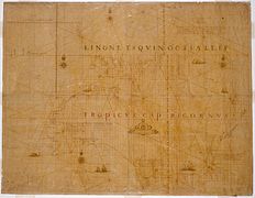 The Abel Tasman map 1644.
 -
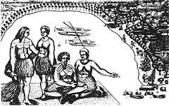
![The first European impression of Māori, at Murderers' Bay. Drawing by Isaack Gilsemans in Abel Tasman's travel journal (1642).[52]](https://upload.wikimedia.org/wikipedia/commons/thumb/6/6e/Gilsemans_1642.jpg/240px-Gilsemans_1642.jpg) The first European impression of Māori, at Murderers' Bay. Drawing by Isaack Gilsemans in Abel Tasman's travel journal (1642). [52]
The first European impression of Māori, at Murderers' Bay. Drawing by Isaack Gilsemans in Abel Tasman's travel journal (1642). [52] -
 Tongatapu, drawing by Isaack Gilsemans
 -
 The bay of Tongatapu with the two ships, drawing by Isaack Gilsemans
Oceania, also known as Oceanica, is a geographical and geopolitical region consisting of numerous lands—mostly islands in the tropical Pacific Ocean and vicinity. [1] [2] The term is often used more specifically to denote a continent comprising Australia and proximate Pacific islands. [3] [4] [5] [6] [7] [8] [9]
The boundaries of Oceania are defined in a number of ways. The narrowest definition is an ethnological division into its three subregions of Melanesia, Micronesia, and Polynesia. [10] The broadest definition is the entire insular region between Asia and the Americas, including Australasia and the Malay Archipelago. [11] Most definitions include parts of Australasia such as Australia, New Zealand, and New Guinea, and parts of Maritime Southeast Asia. [12] [13] [14]
'Oceania' is also biogeographically used as a synonym for either the Australasian ecozone ( Wallacea and Australasia) or the Pacific ecozone (Melanesia, Polynesia, and Micronesia apart either from New Zealand [15] or from mainland New Guinea). [16]
Definitions


Oceania was originally conceived as the lands of the Pacific Ocean, stretching from the Straits of Malacca to the coast of the Americas. It comprised four regions: Polynesia, Micronesia, Malaysia (now called the Malay Archipelago), and Melanesia (now called Australasia). [17]
Nowadays Oceania is defined in a number of ways. The narrowest definition is an ethnological division into its three subregions of Melanesia, Micronesia, and Polynesia. [10] The broadest definition is the entire insular region between Asia and the Americas, including Australasia and the Malay Archipelago. [11] Most definitions include parts of Australasia such as Australia, New Zealand, and New Guinea, and parts of Maritime Southeast Asia. [12] [13] [14]
Oceania is one of eight terrestrial ecozones (ecological regions), which constitute the major ecological regions of the planet. The Oceania ecozone includes all of Micronesia, Fiji, and all of Polynesia except New Zealand. New Zealand, along with New Guinea and nearby islands, part of Philippines islands, Australia, the Solomon Islands, Vanuatu, and New Caledonia, constitute the separate Australasian ecozone. The Malay Archipelago is part of the Indomalaya ecozone. Related to these concepts are Near Oceania, that part of western Island Melanesia which has been inhabited for tens of millennia, and Remote Oceania, which is more recently settled. [18]
In geopolitical terms, New Zealand, the Solomon Islands, Vanuatu and New Caledonia are almost always considered part of Oceania, and Australia and Papua New Guinea are usually considered part of Oceania too. Sometimes Papua province in Indonesia may be included, as Puncak Jaya is often considered the highest peak in Oceania.
The states that occupy Oceania that are not included in geopolitical Oceania are Indonesia, Malaysia (through Malaysian Borneo), Brunei, the Philippines, and East Timor. The islands of the geographic extremes are politically integral parts of Japan (Bonin), the United States (Hawaii), and Chile (Rapa Nui, formerly Easter Island). A smaller geographic definition also exists, which excludes the land on the Sunda Plate, but includes Indonesian New Guinea as part of the Australian continent.
In the geopolitical conception used by the United Nations, International Olympic Committee, and many atlases, Oceania includes Australia and the nations of the Pacific from Papua New Guinea east, but not the Malay Archipelago or Indonesian New Guinea. [14] [19] [20]
Biogeographically, Oceania is used as a synonym for either the Australasian ecozone ( Wallacea and Australasia) or the Pacific ecozone (Melanesia, Polynesia, and Micronesia apart either from New Zealand [15] or from mainland New Guinea [16]).
Other definitions:
- The term 'Oceania' is often used to denote a continent comprising Australia and proximate islands. [5] [7] [8] [9]
- New Zealand forms the south-western corner of the Polynesian Triangle. Its indigenous Māori constitute one of the major cultures of Polynesia. It is also, however, considered part of Australasia. [14]
- The widest definition of Oceania includes the entire region between continental Asia and the Americas, thereby including islands in the Pacific Rim such as the Japanese Archipelago, Taiwan, and the Aleutian islands. [21]
General definitions
- Oceania is pronounced ( IPA):
- Common English name(s): Oceania, Oceanica [24]
- Official English name(s): Oceania
- Adjectival(s): Oceanian
- Demonym(s): Oceanians
The term 'Oceania' was coined as Océanie ca. 1812 by geographer Conrad Malte-Brun. [11] The word Océanie is a French language word derived from the Greek word ὠκεανός (ōkeanós), ocean.
History
Prehistory
Polynesia theories

The Polynesian people are considered to be by linguistic, archaeological and human genetic ancestry a subset of the sea-migrating Austronesian people and tracing Polynesian languages places their prehistoric origins in the Malay Archipelago, and ultimately, in Taiwan. Between about 3000 and 1000 BC speakers of Austronesian languages began spreading from Taiwan into Island Southeast Asia, [25] [26] [27] as tribes whose natives were thought to have arrived through South China about 8,000 years ago to the edges of western Micronesia and on into Melanesia, although they are different from the Han Chinese who now form the majority of people in China and Taiwan.
In the archaeological record there are well-defined traces of this expansion which allow the path it took to be followed and dated with some certainty. It is thought that by roughly 1400 BC, [28] " Lapita Peoples", so-named after their pottery tradition, appeared in the Bismarck Archipelago of northwest Melanesia. This culture is seen as having adapted and evolved through time and space since its emergence "Out of Taiwan". They had given up rice production, for instance, after encountering and adapting to breadfruit in the Bird's Head area of New Guinea. In the end, the most eastern site for Lapita archaeological remains recovered so far has been through work on the archaeology in Samoa. The site is at Mulifanua on Upolu. The Mulifanua site, where 4,288 pottery shards have been found and studied, has a "true" age of c. 1000 BC based on C14 dating. [29] A 2010 study places the beginning of the human archaeological sequences of Polynesia in Tonga at 900 B.C., [30] the small differences in dates with Samoa being due to differences in radiocarbon dating technologies between 1989 and 2010, the Tongan site apparently predating the Samoan site by some few decades in real time.
Within a mere three or four centuries between about 1300 and 900 BC, the Lapita archaeological culture spread 6,000 km further to the east from the Bismarck Archipelago, until it reached as far as Fiji, Tonga, and Samoa. [31] [32] The area of Tonga, Fiji, and Samoa served as a gateway into the rest of the Pacific region known as Polynesia. [33] Ancient Tongan mythologies recorded by early European explorers report the islands of 'Ata and Tongatapu as the first islands being hauled to the surface from the deep ocean by Maui. [34] [35]
Micronesia theories

Micronesia began to be settled several millennia ago, although there are competing theories about the origin and arrival of the first settlers. [36] There are numerous difficulties with conducting archaeological excavations in the islands, due to their size, settlement patterns and storm damage. As a result, much evidence is based on linguistic analysis. [37] The earliest archaeological traces of civilization have been found on the island of Saipan, dated to 1500 BCE or slightly before. [38]
The ancestors of the Micronesians settled there over 4,000 years ago. A decentralized chieftain-based system eventually evolved into a more centralized economic and religious Micronesian Empire centered on Yap and Pohnpei. [39] The prehistory of many Micronesian islands such as Yap are not known very well. [40]
The first people of the Northern Mariana Islands navigated to the islands at some period between 4000 BC to 2000 BC from Southeast Asia. They became known as the Chamorros, and spoke an Austronesian language called Chamorro. The ancient Chamorro left a number of megalithic ruins, including Latte stone. The Refaluwasch, or Carolinian, people came to the Marianas in the 1800s from the Caroline Islands. Micronesian colonists gradually settled the Marshall Islands during the 2nd millennium BC, with inter-island navigation made possible using traditional stick charts. [41]
Melanesia theories

The first settlers of Australia, New Guinea, and the large islands just to the east arrived between 50,000 and 30,000 years ago, when Neanderthals still roamed Europe. [42] The original inhabitants of the group of islands now named Melanesia were likely the ancestors of the present-day Papuan-speaking people. Migrating from Southeast Asia, they appear to have occupied these islands as far east as the main islands in the Solomon Islands, including Makira and possibly the smaller islands farther to the east. [43]
Particularly along the north coast of New Guinea and in the islands north and east of New Guinea, the Austronesian people, who had migrated into the area somewhat more than 3,000 years ago, [42] came into contact with these pre-existing populations of Papuan-speaking peoples.
Melanesians of some islands are one of the few non-European peoples, and the only dark-skinned group of people outside Australia, known to have blond hair.
Indigenous Australians are the original inhabitants of the Australian continent and nearby islands. [44] Indigenous Australians migrated from Africa to Asia around 70,000 years ago [45] and arrived in Australia around 50,000 years ago. [46] [47] The Torres Strait Islanders are indigenous to the Torres Strait Islands, which are at the northernmost tip of Queensland near Papua New Guinea. The term "Aboriginal" is traditionally applied to only the indigenous inhabitants of mainland Australia and Tasmania, along with some of the adjacent islands, i.e.: the "first peoples". Indigenous Australians is an inclusive term used when referring to both Aboriginal and Torres Strait islanders.
The earliest definite human remains found to date are that of Mungo Man, which have been dated at about 40,000 years old, but the time of arrival of the ancestors of Indigenous Australians is a matter of debate among researchers, with estimates dating back as far as 125,000 years ago. [48] There is great diversity among different Indigenous communities and societies in Australia, each with its own unique mixture of cultures, customs and languages. In present-day Australia these groups are further divided into local communities. [49]
European contact and exploration (from 1600s)

Ferdinand Magellan and the Manila Galleons

Oceania was explored by Europeans from the 16th century onwards. In 1519 Ferdinand Magellan sailed down the east coast of South America, found and sailed through the strait that bears his name and on 28 November 1520 entered the Pacific. He then sailed north and caught the trade winds which carried him across the Pacific to the Philippines where he was killed. One surviving ship returned west across the Indian Ocean and the other went north in the hope of finding the westerlies and reaching Mexico. Unable to find the right winds, it was forced to return to the East Indies. The Ferdinand Magellan expedition achieved the first circumnavigation of the world and discovered the Mariana Islands and other islands of Oceania.
In 1565 (44 years later) Andrés de Urdaneta found a wind system that would reliably blow a ship eastward back to the Americas. From then until 1815 the annual Manila Galleons crossed the Pacific from Mexico to the Philippines and back, exchanging Mexican silver for spices and porcelain. Until the time of Captain Cook these were the only large ships to regularly cross the Pacific. The route was purely commercial and there was no exploration of the areas to the north and south. In 1668 the Spanish founded a colony on Guam as a resting place for west-bound galleons. For a long time this was the only non-coastal European settlement in the Pacific.

Abel Tasman

Abel Tasman was the first known European explorer to reach the islands of Van Diemen's Land (now Tasmania) and New Zealand, and to sight the Fiji islands. His navigator François Visscher, and his merchant Isaack Gilsemans, mapped substantial portions of Australia, New Zealand, Tonga and the Fijian islands.
After some exploration, Tasman had intended to proceed in a northerly direction but as the wind was unfavourable he steered east. On 13 December they sighted land on the north-west coast of the South Island, New Zealand, becoming the first Europeans to do so. [50] Proceeding north and then east, he stopped to gather water but was attacked by Māori in waka taua (canoes). Archeological research has shown the Dutch had tried to land at a major agricultural area, which the Māori may have been trying to protect. [51]
On route back to Batavia, Tasman came across the Tongan archipelago on 20 January 1643. While passing the Fiji Islands Tasman's ships came close to being wrecked on the dangerous reefs of the north-eastern part of the Fiji group. He charted the eastern tip of Vanua Levu and Cikobia before making his way back into the open sea. He eventually turned north-west to New Guinea, and arrived at Batavia on 15 June 1643.
For over a century after Tasman's voyages, until the era of James Cook, Tasmania and New Zealand were not visited by Europeans – mainland Australia was visited, but usually only by accident.
Map and drawings from
Abel Tasman's voyages

![The first European impression of Māori, at Murderers' Bay. Drawing by Isaack Gilsemans in Abel Tasman's travel journal (1642).[52]](/info/en/?search=File:Gilsemans_1642.jpg)


Captain James Cook voyages of exploration

Captain James Cook, FRS, RN (7 November 1728 [note 1] – 14 February 1779) was a British explorer, navigator, cartographer, and captain in the Royal Navy. Cook made three voyages to the Pacific Ocean, during which he achieved the first recorded European contact with the eastern coastline of Australia and the Hawaiian Islands, and the first recorded circumnavigation of New Zealand.
On his return voyage to New Zealand in 1774, Cook landed at the Friendly Islands, Easter Island, Norfolk Island, New Caledonia, and Vanuatu.
On his last voyage in 1778, Cook became the first European to visit the Hawaiian Islands and named the archipelago the "Sandwich Islands" after the fourth Earl of Sandwich. [54]
Cook returned to Hawaii in 1779, but was killed in Hawaii in a fight with Hawaiians. He left a legacy of scientific and geographical knowledge which was to influence his successors well into the 20th century and numerous memoria worldwide have been dedicated to him.
In the three voyages Cook sailed thousands of miles across largely uncharted areas of the globe. He mapped lands from New Zealand to Hawaii in the Pacific Ocean in greater detail and on a scale not previously achieved.

Colonisation

British colonisation
In 1789 the Mutiny on the Bounty against William Bligh led to several of the mutineers escaping the Royal Navy and settling on Pitcairn Islands, which later became a British colony. Britain also established colonies in Australia in 1788, New Zealand in 1840 and Fiji in 1872, with much of Oceania becoming part of the British Empire.
Among the last islands in Oceania to be colonised was Niue (1900). In 1887, King Fata-a-iki, who reigned Niue from 1887 to 1896, offered to cede sovereignty to the British Empire, fearing the consequences of annexation by a less benevolent colonial power. The offer was not accepted until 1900. Niue was a British protectorate, but the UK's direct involvement ended in 1901 when New Zealand annexed the island.
French colonisation

In 1842, Tahiti and Tahuata were declared a French protectorate, to allow Catholic missionaries to work undisturbed. In 1880, France annexed Tahiti, changing the status from that of a protectorate to that of a colony. [55]
In 1853, under orders from Napoleon III, Admiral Febvrier Despointes took formal possession of New Caledonia. [56] New Caledonia became a penal colony, and from the 1860s until the end of the transportations in 1897, about 22,000 criminals and political prisoners were sent to New Caledonia. [57]
In the 1880s, France claimed the Tuamotu Archipelago, which formerly belonged to the Pōmare Dynasty, without formally annexing it. Having declared a protectorate over Tahuata in 1842, the French regarded the entire Marquesas Islands as French. In 1885, France appointed a governor and established a general council, thus giving it the proper administration for a colony. The islands of Rimatara and Rūrutu unsuccessfully lobbied for British protection in 1888, so in 1889 they were annexed by France. The first official name for the colony was Établissements de l'Océanie (Settlements in Oceania) but was later changed in 1903 to Établissements Français de l'Océanie (French Settlements in Oceania). [58]
Spanish colonisation
The Spanish explorer Alonso de Salazar landed in the Marshall Islands in 1529. They were named by Krusenstern, after English explorer John Marshall, who visited them together with Thomas Gilbert in 1788, in route from Botany Bay to Canton (two ships of the First Fleet). The Marshall Islands were claimed by Spain in 1874.
Dutch colonisation
In 1606 Luís Vaz de Torres explored the southern coast of New Guinea from Milne Bay to the Gulf of Papua including Orangerie Bay which he named Bahía de San Lorenzo. His expedition also discovered Basilaki Island naming it Tierra de San Buenaventura, which he claimed for Spain in July 1606. [59] On October 18 his expedition reached the western part of the island in present-day Indonesia, and also claimed the territory for the King of Spain.
.png)
The Netherlands formally claimed the western half of the island of New Guinea as Netherlands New Guinea in 1828. In 1883, following a short-lived French annexation of New Ireland, the British colony of Queensland annexed south-eastern New Guinea. However, the Queensland government's superiors in the United Kingdom revoked the claim, and (formally) assumed direct responsibility in 1884, when Germany claimed north-eastern New Guinea as the protectorate of German New Guinea (also called Kaiser-Wilhelmsland).
The first Dutch government posts were established in 1898 and in 1902: Manokwari on the north coast, Fak-Fak in the west and Merauke in the south at the border with British New Guinea. The German, Dutch and British colonial administrators each attempted to suppress the still-widespread practices of inter-village warfare and headhunting within their respective territories. [60]
In 1905 the British government transferred some administrative responsibility over southeast New Guinea to Australia (which renamed the area " Territory of Papua"); and in 1906, transferred all remaining responsibility to Australia. During World War I, Australian forces seized German New Guinea, which in 1920 became the Territory of New Guinea, to be administered by Australia under a League of Nations mandate. The territories under Australian administration became collectively known as The Territories of Papua and New Guinea (until February 1942).
German colonisation
Germany established colonies in New Guinea in 1884, and Samoa in 1900.
Following papal mediation and German compensation of $4.5 million, Spain recognized a German claim in 1885. Germany established a protectorate and set up trading stations on the islands of Jaluit and Ebon to carry out the flourishing copra (dried coconut meat) trade. Marshallese Iroij (high chiefs) continued to rule under indirect colonial German administration.

American colonisation
The United States also expanded into the Pacific, beginning with Baker Island and Howland Island in 1857, and with Hawaii becoming a U.S. territory in 1898. Disagreements between the US, Germany and UK over Samoa led to the Tripartite Convention of 1899.
Samoa aligned its interests with the U.S. in a Deed of Succession, signed by the Tui Manuʻa (supreme chief of Manuʻa) on July 16, 1904, at the Crown residence of the Tuimanuʻa called the Faleula in the place called Lalopua (from Official documents of the Tuimanuʻa government, 1893; Office of the Governor, 2004).
Cession followed the Tripartite Convention of 1899 that partitioned the eastern islands of Samoa (including Tutuila and the Manuʻa Group) from the western islands of Samoa (including ʻUpolu and Savaiʻi).
Japanese colonisation
At the beginning of World War I, Japan assumed control of the Marshall Islands. The Japanese headquarters was established at the German center of administration, Jaluit. On 31 January 1944, during World War II, American forces landed on Kwajalein atoll and U.S. Marines and Army troops later took control of the islands from the Japanese on February 3, following intense fighting on Kwajalein and Enewetak atolls. In 1947, the United States, as the occupying power, entered into an agreement with the UN Security Council to administer much of Micronesia, including the Marshall Islands, as the Trust Territory of the Pacific Islands.
During World War II, Japan colonized many Oceanic colonies by wresting control from western powers.
Samoan Crisis 1887-1889


The Samoan Crisis was a confrontation standoff between the United States, Imperial Germany and Great Britain from 1887 to 1889 over control of the Samoan Islands during the Samoan Civil War. The incident involved three American warships, USS Vandalia, USS Trenton and USS Nipsic and three German warships, SMS Adler, SMS Olga, and SMS Eber, keeping each other at bay over several months in Apia harbour, which was monitored by the British warship HMS Calliope.
The standoff ended on 15 and 16 March when a cyclone wrecked all six warships in the harbour. Calliope was able to escape the harbour and survived the storm. Robert Louis Stevenson witnessed the storm and its aftermath at Apia and later wrote about what he saw. [61] The Samoan Civil War continued, involving Germany, United States and Britain, eventually resulting, via the Tripartite Convention of 1899, in the partition of the Samoan Islands into American Samoa and German Samoa. [62]
World War One

The Asian and Pacific Theatre of World War I was a conquest of German colonial possession in the Pacific Ocean and China. The most significant military action was the Siege of Tsingtao in what is now China, but smaller actions were also fought at Battle of Bita Paka and Siege of Toma in German New Guinea.
All other German and Austrian possessions in Asia and the Pacific fell without bloodshed. Naval warfare was common; all of the colonial powers had naval squadrons stationed in the Indian or Pacific Oceans. These fleets operated by supporting the invasions of German held territories and by destroying the East Asia Squadron.
.jpg)
One of the first land offensives in the Pacific theatre was the Occupation of German Samoa in August 1914 by New Zealand forces. The campaign to take Samoa ended without bloodshed after over 1,000 New Zealanders landed on the German colony, supported by an Australian and French naval squadron.
Australian forces attacked German New Guinea in September 1914: 500 Australians encountered 300 Germans and native policemen at the Battle of Bita Paka; the Allies won the day and the Germans retreated to Toma. A company of Australians and a British warship besieged the Germans and their colonial subjects, ending with a German surrender. [63]
After the fall of Toma, only minor German forces were left in New Guinea and these generally capitulated once met by Australian forces. In December 1914, one German officer near Angorum attempted resist the occupation with thirty native police but his force deserted him after they fired on an Australian scouting party and he was subsequently captured. [63]
German Micronesia, the Marianas, the Carolines and the Marshall Islands also fell to Allied forces during the war.
World War Two

.jpg)
.jpg)
The Pacific front saw major action during the Second World War, mainly between the belligerents Japan and the United States.
The attack on Pearl Harbor [note 2] was a surprise military strike conducted by the Imperial Japanese Navy against the United States naval base at Pearl Harbor, Hawaii, on the morning of December 7, 1941 (December 8 in Japan). The attack led to the United States' entry into World War II.
The attack was intended as a preventive action in order to keep the U.S. Pacific Fleet from interfering with military actions the Empire of Japan was planning in Southeast Asia against overseas territories of the United Kingdom, the Netherlands, and the United States. There were simultaneous Japanese attacks on the U.S.-held Philippines and on the British Empire in Malaya, Singapore, and Hong Kong.
The Japanese subsequently invaded New Guinea, the Solomon Islands and other Pacific islands. The Japanese were turned back at the Battle of the Coral Sea and the Kokoda Track campaign before they were finally defeated in 1945.
Some of the most prominent Oceanic battlegrounds were the Solomon Islands campaign, the Air raids on Darwin, the Kokada Track, and the Borneo campaign.
In 1940 the administration of French Polynesia recognised the Free French Forces and many Polynesians served in World War II. Unknown at the time to French and Polynesians, the Konoe Cabinet in Imperial Japan on 16 September 1940 included French Polynesia among the many territories which were to become Japanese possessions in the post-war world – though in the course of the war in the Pacific the Japanese were not able to launch an actual invasion of the French islands.
Nuclear testing in Oceania

Due to its low population, Oceania was a popular location for atmospheric and underground nuclear tests. Tests were conducted in various locations by the United Kingdom ( Operation Grapple and Operation Antler), the United States ( Bikini atoll and the Marshall Islands) and France ( Moruroa), often with devastating consequences for the inhabitants.
From 1946 to 1958, the Marshall Islands served as the Pacific Proving Grounds for the United States, and was the site of 67 nuclear tests on various atolls. The world's first hydrogen bomb, codenamed " Mike", was tested at the Enewetak atoll in the Marshall Islands on November 1 (local date) in 1952, by the United States.
In 1954, fallout from the American Castle Bravo hydrogen bomb test in the Marshall Islands was such that the inhabitants of the Rongelap Atoll were forced to abandon their island. Three years later the islanders were allowed to return, but suffered abnormally high levels of cancer. They were evacuated again in 1985 and in 1996 given $45 million in compensation.
A series of British tests were also conducted in the 1950s at Maralinga in South Australia, forcing the removal of the Pitjantjatjara and Yankunytjatjara peoples from their ancestral homelands.
In 1962, France's early nuclear testing ground of Algeria became independent and the atoll of Moruroa in the Tuamotu Archipelago was selected as the new testing site. Moruroa atoll became notorious as a site of French nuclear testing, primarily because tests were carried out there after most Pacific testing had ceased. These tests were opposed by most other nations in Oceania. The last atmospheric test was conducted in 1974, and the last underground test in 1996.
French nuclear testing in the Pacific was controversial in the 1980s, in 1985 French agents caused the Sinking of the Rainbow Warrior in Auckland to prevent it from arriving at the test site in Moruroa. In September 1995, France stirred up widespread protests by resuming nuclear testing at Fangataufa atoll after a three-year moratorium. The last test was on 27 January 1996. On 29 January 1996, France announced that it would accede to the Comprehensive Test Ban Treaty, and no longer test nuclear weapons.
East Timor
.svg)
In 1975, East Timor declared itself independent, following the withdrawal of its coloniser Portugal. Nine days later the area was invaded by Indonesia. Because the East Timorese FRETILIN party had some communist support, the Indonesia government was able to portray its actions as anti-communist, and thus won the backing of the United States and Australia. A detailed statistical report prepared for the Commission for Reception, Truth and Reconciliation in East Timor cited a lower range of 102,800 conflict-related deaths in the Indonesian occupation period 1974–1999, namely, approximately 18,600 killings and 84,200 'excess' deaths from hunger and illness. [68] Amnesty International estimates the death toll to be about 200,000. [69] A guerrilla campaign against Indonesia was carried out by Falintil throughout the period of occupation.
In 1999 a United Nations supervised referendum was held as a result of an agreement between Indonesia, Portugal and the United States. The East Timorese voted for full independence. The Indonesian military backed militia attacks within East Timor, and a peacekeeping force consisting mostly of Australian and New Zealand troops was sent in. East Timor's independence was recognised in 2006, but since then there have been two major outbreaks of violence, each requiring the intervention of UN-backed troops.
Fijian coups

Fiji has suffered several coups d'état: military in 1987 and 2006 and civilian in 2000. All were ultimately due to ethnic tension between indigenous Fijians and Indo-Fijians, who originally came to the islands as indentured labour in the late nineteenth and early twentieth century. The 1987 coup followed the election of a multi-ethnic coalition, which Lieutenant Colonel Sitiveni Rabuka overthrew, claiming racial discrimination against ethnic Fijians. The coup was denounced by the United Nations and Fiji was expelled from the Commonwealth of Nations.
The 2000 coup was essentially a repeat of the 1987 affair, although it was led by civilian George Speight, apparently with military support. Commodore Frank Bainimarama, who was opposed to Speight, then took over and appointed a new Prime Minister. Speight was later tried and convicted for treason. Many indigenous Fijians were unhappy at the treatment of Speight and his supporters, feeling that the coup had been legitimate. In 2006 the Fijian parliament attempted to introduce a series of bills which would have, amongst other things, pardoned those involved in the 2000 coup. Bainimarama, concerned that the legal and racial injustices of the previous coups would be perpetuated, staged his own coup. It was internationally condemned, and Fiji again suspended from the Commonwealth.
In 2006 the then Australia Defence Minister, Brendan Nelson, warned Fijian officials of an Australian Naval fleet within proximity of Fiji that would respond to any attacks against its citizens. [70]
Bougainville Civil War
The Australian government estimated that anywhere between 15,000 and 20,000 people could have died in the Bougainville Civil War. More conservative estimates put the number of combat deaths as 1–2,000. [71]
From 1975, there were attempts by the Bougainville Province to secede from Papua New Guinea. These were resisted by Papua New Guinea primarily because of the presence in Bougainville of the Panguna mine, which was vital to Papua New Guinea's economy. The Bougainville Revolutionary Army began attacking the mine in 1988, forcing its closure the following year. Further BRA activity led to the declaration of a state of emergency and the conflict continued until about 2005, when successionist leader and self-proclaimed King of Bougainville Francis Ona died of malaria. Peacekeeping troops led by Australia have been in the region since the late 1990s, and a referendum on independence will be held in the 2010s.
Modern age

In 1946, Polynesians were granted French citizenship and the islands' status was changed to an overseas territory; the islands' name was changed in 1957 to Polynésie Française (French Polynesia).
Australia and New Zealand became dominions in the 20th century, adopting the Statute of Westminster Act in 1942 and 1947 respectively, marking their legislative independence from the United Kingdom. Hawaii became a U.S. state in 1959.
Fiji and Tonga became independent in 1970, with many other nations following in the 1970s and 1980s. The South Pacific Forum was founded in 1971, which became the Pacific Islands Forum in 2000. Bougainville Island, geographically part of the Solomon Islands but politically part of Papua New Guinea, tried unsuccessfully to become independent in 1975, and a civil war followed in the early 1990s, with it later being granted autonomy.
On May 1, 1979, in recognition of the evolving political status of the Marshall Islands, the United States recognized the constitution of the Marshall Islands and the establishment of the Government of the Republic of the Marshall Islands. The constitution incorporates both American and British constitutional concepts.
In 1852, French Polynesia was granted partial internal autonomy; in 1984, the autonomy was extended. French Polynesia became a full overseas collectivity of France in 2004.
East Timor declared independence from Portugal in 1975, but was invaded by Indonesia, before it was granted full independence in 2002.
Between 2001 and 2007 Australia's Pacific Solution policy transferred asylum seekers to several Pacific nations, including the Nauru detention centre. Australia, New Zealand and other nations took part in the Regional Assistance Mission to Solomon Islands from 2003 after a request for aid.
Geography

Oceania consists of numerous lands—mostly islands in the tropical Pacific Ocean and vicinity. [1] Included are parts of three geological continents, Eurasia, Australia, and Zealandia, as well the non-continental volcanic islands of the Philippines, Wallacea, and the open Pacific. It extends to Sumatra in the west, the Bonin Islands in the northwest, the Hawaiian Islands in the northeast, Rapa Nui and Sala y Gómez Island in the east, and Macquarie Island in the south, but excludes Taiwan, the Japanese Archipelago (including the Ryukyu Islands), and Aleutian Islands of the margins of Asia. [72] [73]
Physical Geography
The Pacific region covers a macrogeogràfica located between South East Asia and America, with Australia as the largest land mass, followed by the smaller nearby islands of Papua New Guinea and New Zealand, in addition to the 25,000 small islands scattered the Pacific . The name comes from the fact that Oceania, unlike other continents, this consists mainly of the land area of the Pacific and adjacent seas. Oceans is washed Indian, Antarctic glacier and the Pacific, Asia and separated by seas Timor id ' Arafura, a total of 25,760 km of coastline. Oceania is the driest continent on the planet, the least populated, the plan, which has the oldest land and also less fertile.
Topography
The average altitude of Oceania is low: 340 meters. In Australia dominated plains and plateaus low, and the island is home to the only significant continental mountain range: the Great Dividing Range . New Guinea and the islands of New Zealand are the rugged relief and some peaks exceeding 4,000 meters. There are some islands in the Pacific which are mountainous with volcanoes active as Samoa and Hawaii, and other rather low, which can form atolls, as called atolls of the Pacific, notably the Kwajalein Atoll. Through Micronesia extends the Mariana Trench, which has probed the deepest point of the Earth, the Challenger Deep, in the southwest of the island of Guam.
The highest mountain of Australia, Mount Mawson of 2,745 m, is small Heard Island in the Indian Ocean south, although the Mount Kosciuszko, with 2,228 m, is the main elevation of the Australian continent.
Climate
The climate is strongly influenced by ocean currents (incloïent no El Niño, which causes droughts periodic) system and the seasonal tropical low atmospheric pressure that produces frequent typhoons in northern Australia . Except for New Zealand and part of Australia (who enjoy a mild climate or desert ) in Oceania predominantly warm climate due to its location intertropical (for example, equatorial in New Guinea and tropical in Hawaii).
The rainfall is abundant in the eastern coast of the mountainous islands (exposed to the trade winds ), while the western coasts (leeward) suffer greater aridity . Desert or semi-arid region is the largest of all this territory: 40% is covered by dunes of sand.
Hydrography
One can speak of a real river system to the larger islands. The river system is made up of the continent Murray-Darling in Australia, with numerous tributaries seasonal character. [74] The rivers of New Guinea and New Zealand are short and some increase its flow by the presence of glaciers. [75] [76]
Islands
Oceania has more than 25,000 islands and islets, but only four are large: Australia (86% of the area of Oceania and the largest island of the Earth ), New Guinea and the two islands that make up New Zealand . There are thousands of small islands and islets scattered over the Pacific, being its most coral reefs source volcanic grouped in three main islands known as Micronesia, Melanesia and Polynesia. [77]
.jpg)

|


Demographics
Oceania
.svg)
Wider Geographic Oceania.
Little of the South Pacific is apparent at this scale, though Hawaii is just visible near the eastern horizon.
| Area | 10,975,600 km2 (4,237,700 sq mi) |
|---|---|
| Population | 37.8 million (2010) |
| Time Zones | UTC+7 ( Western Indonesian Time) to UTC-6 ( Easter Island) |
| Largest Cities |
Jakarta Manila Sydney Bandung Melbourne Surabaya Medan |
.svg)
Narrower Geographic Oceania.
Island Melanesia, Micronesia, and Polynesia (apart from New Zealand)
| Area | 183,000 km2 (71,000 sq mi) |
|---|---|
| Population | 5.2 million (2008) |
| Time Zones | UTC+9 ( Palau) to UTC-6 ( Easter Island) |
| Largest Cities |
Honolulu Nouméa Suva Papeete Honiara |
The demographic table below shows the subregions and countries of geopolitical Oceania. [14] The countries and territories in this table are categorized according to the scheme for geographic subregions used by the United Nations. The information shown follows sources in cross-referenced articles; where sources differ, provisos have been clearly indicated. These territories and regions are subject to various additional categorisations, of course, depending on the source and purpose of each description.
| Name of region, followed by countries and their flags [78] |
Area (km2) |
Population |
Population density (per km2) |
Capital | ISO 3166-1 |
|---|---|---|---|---|---|
| Australasia [79] | |||||
| Ashmore and Cartier Islands ( Australia) | 199 | ||||
| 7,686,850 | 23,034,879 | 2.7 | Canberra | AU | |
| 135 | 1,493 | 3.5 | Flying Fish Cove | CX | |
| 14 | 628 | 45.1 | West Island | CC | |
| Coral Sea Islands (Australia) | 10 | 4 | |||
| 268,680 | 4,465,900 | 16.5 | Wellington | NZ | |
| 35 | 2,302 | 61.9 | Kingston | NF | |
| Melanesia [82] | |||||
| 18,270 | 856,346 | 46.9 | Suva | FJ | |
| 19,060 | 240,390 | 12.6 | Nouméa | NC | |
| 462,840 | 5,172,033 | 11.2 | Port Moresby | PG | |
| 28,450 | 494,786 | 17.4 | Honiara | SB | |
| 12,200 | 240,000 | 19.7 | Port Vila | VU | |
| Micronesia | |||||
| 702 | 135,869 | 193.5 | Palikir | FM | |
| 549 | 160,796 | 292.9 | Hagåtña | GU | |
| 811 | 96,335 | 118.8 | South Tarawa | KI | |
| 181 | 73,630 | 406.8 | Majuro | MH | |
| 21 | 12,329 | 587.1 | Yaren (de facto) | NR | |
| 477 | 77,311 | 162.1 | Saipan | MP | |
| 458 | 19,409 | 42.4 | Melekeok [84] | PW | |
|
|
2 | 12 | Wake Island | UM | |
| Polynesia | |||||
| 199 | 68,688 | 345.2 | Pago Pago, Fagatogo [85] | AS | |
| 240 | 20,811 | 86.7 | Avarua | CK | |
| 164 | 5,761 | 31 | Hanga Roa | CL | |
| 4,167 | 257,847 | 61.9 | Papeete | PF | |
| 16,636 | 1,360,301 | 81.8 | Honolulu | US | |
| 260 | 2,134 | 8.2 | Alofi | NU | |
| 5 | 47 | 10 | Adamstown | PN | |
| 2,944 | 179,000 | 63.2 | Apia | WS | |
| 10 | 1,431 | 143.1 | Nukunonu | TK | |
| 748 | 106,137 | 141.9 | Nukuʻalofa | TO | |
| 26 | 11,146 | 428.7 | Funafuti | TV | |
| 274 | 15,585 | 56.9 | Mata-Utu | WF | |
| Total | 8,525,989 | 35,669,267 | 4.2 | ||
| Total minus mainland Australia | 839,139 | 13,641,267 | 16.1 | ||
Language
Native languages of Oceania fall into three major geographic groups:
- The large Austronesian language family, with such languages as Malay (Indonesian), Tagalog (Filipino), and Polynesian languages such as Maori and Hawaiian
- The Aboriginal Australian languages, including the large Pama–Nyungan family
- The Papuan languages of New Guinea and neighbouring islands, including the large Trans–New Guinea family
Contact between Austronesian and Papuan resulted in several instances in mixed languages such as Maisin.
Colonial languages include English in Australia, New Zealand, Hawaii, and many other territories; French in New Caledonia and French Polynesia, Portuguese in East Timor, Japanese in the Bonin Islands, Spanish on Easter Island.
There are also Creoles formed from the interaction of Malay or the colonial languages with indigenous languages, such as Tok Pisin, Bislama, Chavacano, various Malay trade and creole languages, Hawaiian Pidgin, Norfuk, and Pitkern.
Finally, immigrants brought their own languages, such as Mandarin, Italian, Arabic, Cantonese, Greek and others in Australia, [86] or Fiji Hindi in Fiji.
There are two kinds of languages: the indigenous (although not officially recognized them mainstream, except Samoan, the Nauru and Tongan) and introduced by the colonisers (be it the English the most common).
Indigenous Languages
Main article: Languages ocean
Employment in Europe, the disease contagious and alcoholism, and the misery caused by the expropriation of the most fertile land by Europeans, did reduce the number of these languages. Belong to the Eastern Ocean or family Austronesian (sub Melanesian, Polynesian and Micronesian) and the many families macroagrupaments of Australian languages and Papuan. [87] [88]
Regarding the Polynesian languages, these languages are spoken in Polynesia to New Zealand and some neighboring islands of Micronesia and Melanesia . The Maori is the most spoken with 200,000 speakers in New Zealand . The Samoan, with 130,000 speakers in Samoa, is the official language of this country. The Tahitian is spoken by 30,000 people in the Society Islands, while Hawaiian (spoken by about 10,000 people, 2% of the archipelago) tends to disappear in favor of English and Japanese . [89]
Among the Melanesian languages, is spoken in the Fiji Fiji for 170,000 (40% of the population), and the sasak tasiriki in Vanuatu, and the Malu vatouranga to Solomon, etc.. Note that most of these languages do not get to have more than 10,000 speakers. [90]
Micronesian languages are spoken in Micronesia and the most important are the ponapeà, Carolina, Marshall, the Gilbert and so on. In the Mariana Islands is spoken Chamorro and Palace Palace. [91]
The Australian languages are, more or less, 260 are exclusive use for 50,000 people. [92]
Languages introduced
- Among other areas, the English spoken in Australia (16 million million) and New Zealand (3,000,000).
- The Japanese is spoken in Hawaii by some 250,000 people and has virtually disappeared from the Palau Islands and Mariana result of the expulsion of the Japanese by the United States after the end of World War II in 1945. [93]
- The French is spoken in New Caledonia and Tahiti.
- The Chinese is spoken by 50,000 people in Hawaii.
- The Hindi language is the 234,000 Indians in Fiji. [94]
Religion
The predominant religion in Oceania is Christianity. [95] Traditional religions are often animist and prevalent among traditional tribes is the belief in spirits (masalai in Tok Pisin) representing natural forces. [96] In recent Australian and New Zealand censuses, large proportions of the population say they belong to " No religion" (which includes atheism, agnosticism, secular humanism, and rationalism). In Tonga, everyday life is heavily influenced by Polynesian traditions and especially by the Christian faith. The Bahá'í House of Worship in Tiapapata, Samoa is one of seven designations administered in the Baha'i faith.
Politics


Signed and ratified Treaty of Rarotonga
The Treaty of Rarotonga is the common name for the South Pacific Nuclear Free Zone Treaty, which formalizes a nuclear-weapon-free zone in the South Pacific. The treaty bans the use, testing, and possession of nuclear weapons within the borders of the zone. [97] [98] [99]
It was signed by the South Pacific nations of Australia, the Cook Islands, Fiji, Kiribati, Nauru, New Zealand, Niue, Papua New Guinea, the Solomon Islands, Tonga, Tuvalu, Vanuatu and Western Samoa on the island of Rarotonga (where the capital of the Cook Islands is located) on August 6, 1985, came into force with the 8th ratification, and has since been ratified by all of those states.
The Federated States of Micronesia, Marshall Islands, and Palau are not party to the treaties but are eligible to become parties should they decide to join the treaty in the future. [100]
Culture
Cannibalism (historical)


Constant warfare and cannibalism between warring tribes were quite rampant and very much part of everyday life. [101] [102] During the 19th century, Ratu Udre Udre is said to have consumed 872 people and to have made a pile of stones to record his achievement. [103]
According to Deryck Scarr ("A Short History of Fiji", 1984, page 3), "Ceremonial occasions saw freshly killed corpses piled up for eating. 'Eat me!' was a proper ritual greeting from a commoner to a chief." Scarr also reported that the posts that supported the chief's house or the priest's temple would have sacrificed bodies buried underneath them, with the rationale that the spirit of the ritually sacrificed person would invoke the gods to help support the structure, and "men were sacrificed whenever posts had to be renewed" (Scarr, page 3). Also, when a new boat, or drua, was launched, if it was not hauled over men as rollers, crushing them to death, "it would not be expected to float long" (Scarr, page 19). Fijians today regard those times as "na gauna ni tevoro" (time of the devil). The ferocity of the cannibal lifestyle deterred European sailors from going near Fijian waters, giving Fiji the name Cannibal Isles; as a result, Fiji remained unknown to the rest of the world. [104]
The ferocity of the cannibal lifestyle deterred European sailors from going near Fijian waters, giving Fiji the name "Cannibal Isles". The dense population of Marquesas Islands, Polynesia, was concentrated in the narrow valleys, and consisted of warring tribes, who sometimes practiced cannibalism on their enemies. W. D. Rubinstein wrote:
It was considered a great triumph among the Marquesans to eat the body of a dead man. They treated their captives with great cruelty. They broke their legs to prevent them from attempting to escape before being eaten, but kept them alive so that they could brood over their impending fate. ... With this tribe, as with many others, the bodies of women were in great demand. [105]
There were other well-documented Oceanic cultures that engaged in regular eating of the dead, such as New Zealand's Māori. In an 1809 incident known as the Boyd massacre, about 66 passengers and crew of the Boyd were killed and eaten by Māori on the Whangaroa peninsula, Northland. Cannibalism was already a regular practice in Māori wars. [106] In another instance, on July 11, 1821, warriors from the Ngapuhi tribe killed 2,000 enemies and remained on the battlefield "eating the vanquished until they were driven off by the smell of decaying bodies". [107] Māori warriors fighting the New Zealand government in Titokowaru's War in New Zealand's North Island in 1868–69 revived ancient rites of cannibalism as part of the radical Hauhau movement of the Pai Marire religion. [108] Other islands in the Pacific were home to cultures that allowed cannibalism to some degree. In parts of Melanesia, cannibalism was still practiced in the early 20th century, for a variety of reasons — including retaliation, to insult an enemy people, or to absorb the dead person's qualities. [109]
Sport
Pacific Games
The Pacific Games (formerly known as the South Pacific Games) is a multi-sport event, much like the Olympics on a much smaller scale, with participation exclusively from countries around the Pacific. It is held every four years and began in 1963. Australia and New Zealand do not compete at the Pacific Games.
Association football (soccer)
The Oceania Football Confederation (OFC) is one of six association football confederations [110] under the auspices of FIFA, the international governing body of the sport. The OFC is the only confederation without an automatic qualification to the World Cup Finals. Currently the winner of the OFC qualification tournament must play off against an Asian confederation side to qualify for the World Cup. [111] [112]
Currently, Vanuatu is the only country in Oceania to call football (soccer) its national sport.
Oceania has been represented at four World Cup finals tournaments — Australia in 1974, 2006 and 2010, and New Zealand in 1982 and 2010. In 2006, Australia joined the Asian Football Confederation and qualified for the 2010 World cup as an Asian entrant. New Zealand qualified through the Oceania Confederation, winning its playoff against Bahrain. 2010 was the first time two countries from Oceania had qualified at the same time, albeit through different confederations.
Australian rules football
Australian rules football is the national sport in Nauru [113] and is the most popular football code in Australia in terms of attendance. [114] It has a large following in Papua New Guinea, where it is the second most popular sport after Rugby League. [115]
Cricket

Cricket is a popular summer sport in Australia and New Zealand. Australia had ruled International cricket as the number one team for more than a decade, and have won four Cricket World Cups and have been runner-up for two times, making them the most successful cricket team. New Zealand is also considered a strong competitor in the sport, with the New Zealand Cricket Team, also called the Black Caps, enjoying success in many competitions. Both Australia and New Zealand are Full members of the ICC. Fiji, Vanuatu and Papua New Guinea are some of the Associate/Affiliate members of the ICC from Oceania that are governed by ICC East Asia-Pacific. Beach Cricket, a greatly simplified variant of cricket played on a sand beach, is also a popular recreational sport in Australia.
Cricket is culturally a significant sport for summer in Oceania. The Boxing Day Test is very popular in Australia, conducted every year on 26 December at the Melbourne Cricket Ground, Melbourne.
Rugby League
Rugby league is a popular sport throughout Oceania, and is the national sport of Papua New Guinea [116] (the second most populous country in Oceania after Australia) and is very popular in Australia [117] and attracts significant attention across New Zealand and the Pacific Islands. [118]
Australia and New Zealand are two of the most successful sides in the world. [119] Australia has won the Rugby League World Cup a record ten times (most recently defeating New Zealand 34–2 in 2013) while New Zealand won their first World Cup in 2008. Australia hosted the second tournament in 1957. Australia and New Zealand jointly hosted it in 1968 and 1977. New Zealand hosted the final for the first time in 1985 – 1988 tournament and Australia hosted the last tournament in 2008.
Rugby Union

Rugby union is one of the region's most prominent sports, [120] and is the national sport of New Zealand, [121] Samoa, [121] Fiji and Tonga. [121] Fiji's sevens team is one of the most successful in the world, as is New Zealand's.
New Zealand and Australia have won the Rugby World Cup a record two times (tied with South Africa who have also won it two times). New Zealand won the inaugural Rugby World Cup in 1987 which was hosted by Australia and New Zealand. Australia hosted it in 2003 and New Zealand hosted it in 2011.
See also
|
Notes
- ^ Old style date: 27 October
- ^ Also known as the Battle of Pearl Harbor, [64] the Hawaii Operation or Operation AI by the Japanese Imperial General Headquarters, [65] [66] and Operation Z during planning. [67]
References
- ^ a b ""Oceanica" definition". The Free Dictionary. Retrieved 2 April 2013.
- ^ For a history of the term, see Douglas & Ballard (2008) Foreign bodies: Oceania and the science of race 1750–1940
- ^ Atlas of Canada Web Master (2004-08-17). "The Atlas of Canada - The World - Continents". Atlas.nrcan.gc.ca. Retrieved 2009-04-17.
- ^ "Encarta Mexico "Oceanía"". Mx.encarta.msn.com. Archived from the original on 2009-11-01. Retrieved 2009-04-17.
- ^
a
b
Lewis, Martin W. (1997). The Myth of Continents: a Critique of Metageography. Berkeley: University of California Press. p. 32.
ISBN
0-520-20742-4.
Interestingly enough, the answer [from a scholar who sought to calculate the number of continents] conformed almost precisely to the conventional list: North America, South America, Europe, Asia, Oceania (Australia plus New Zealand), Africa, and Antarctica.
{{
cite book}}
: Unknown parameter|coauthors=ignored (|author=suggested) ( help) - ^ Current IOC members. International Olympic Committee: Turin 2006.
- ^ a b Son, George Philip (2003). Philip's E.A.E.P Atlas. p. 79. ISBN 9789966251251.
- ^ a b Scholastic Atlas of the World. 2003. "Oceania is the smallest of all the continents"
- ^ a b Composition of macro geographical (continental) regions, geographical sub-regions, and selected economic and other groupings, United Nations Statistics Division. Revised August 28, 2007. Accessed on line October 11, 2007.
- ^ a b "Oceania"[ dead link]. 2005. The Columbia Encyclopedia, 6th ed. Columbia University Press.
- ^ a b c "Oceania". Oxford English Dictionary (Online ed.). Oxford University Press. (Subscription or participating institution membership required.)
- ^ a b Merriam Webster's Online Dictionary (based on Collegiate vol., 11th ed.) 2006. Springfield, MA: Merriam-Webster, Inc.
- ^ a b See, e.g., The Atlas of Canada - The World - Continents
- ^ a b c d e "United Nations Statistics Division - Countries of Oceania". Millenniumindicators.un.org. Retrieved 2009-04-17. Cite error: The named reference "unsd-m49" was defined multiple times with different content (see the help page).
- ^ a b Udvardy. 1975. A classification of the biogeographical provinces of the world
- ^ a b Steadman. 2006. Extinction & biogeography of tropical Pacific birds
- ^ d'Urville, Jules-Sébastien-César Dumont; Ollivier, Isabel; De Biran, Antoine; Clark, Geoffrey (2003). "On the Islands of the Great Ocean". The Journal of Pacific History. 38 (2). Taylor & Francis, Ltd.: 163–174. doi: 10.1080/0022334032000120512. JSTOR 25169637. S2CID 162374626.
- ^ Ben Finney, The Other One-Third of the Globe, Journal of World History, Vol. 5, No. 2, Fall, 1994.
- ^ Atlas of Canada Web Master (2004-08-17). "The Atlas of Canada – The World – Continents". Atlas.nrcan.gc.ca. Retrieved 2009-04-17.
- ^ Current IOC members.
- ^ "Oceania". Britannica.com. Retrieved 2012-12-26.
- ^ Pronunciation: The New Oxford Dictionary of English (1998) ISBN 0-19-861263-X — p.1282 "Oceania /ˌəʊsɪˈɑːnɪə, -ʃɪ-/".
- ^ "Oceania". Dictionary.com. Random House, Inc. 2012.
- ^ ""Oceanica" defined by Memidex/WordNet". Memidex.com. 2009-03-20. Retrieved 2009-04-17.
- ^ Hage, P.; Marck, J. (2003). "Matrilineality and Melanesian Origin of Polynesian Y Chromosomes". Current Anthropology. 44 (S5): S121. doi: 10.1086/379272. S2CID 224791767.
-
^ Kayser, M.; Brauer, S.; Cordaux, R.; Casto, A.; Lao, O.; Zhivotovsky, L. A.; Moyse-Faurie, C.; Rutledge, R. B.; Schiefenhoevel, W. (2006). "Melanesian and Asian origins of Polynesians: mtDNA and Y chromosome gradients across the Pacific". Molecular Biology and Evolution. 23 (11): 2234–2244.
doi:
10.1093/molbev/msl093.
PMID
16923821.
{{ cite journal}}:|first10=missing|last10=( help);|first11=missing|last11=( help);|first12=missing|last12=( help);|first13=missing|last13=( help);|first14=missing|last14=( help);|first15=missing|last15=( help) -
^ Su, B.; Underhill, P.; Martinson, J.; Saha, N.; McGarvey, S. T.; Shriver, M. D.; Chu, J.; Oefner, P.; Chakraborty, R. (2000).
"Polynesian origins: Insights from the Y chromosome".
PNAS. 97 (15): 8225–8228.
doi:
10.1073/pnas.97.15.8225.
PMC
26928.
PMID
10899994.
{{ cite journal}}:|first10=missing|last10=( help);|first11=missing|last11=( help) - ^ Kirch, P. V. (2000). On the road of the wings: an archaeological history of the Pacific Islands before European contact. London: University of California Press. ISBN 0520234618. Quoted in Kayser, M.; et al. (2006).
- ^ Green, Roger C.; Leach, Helen M. (1989). "New Information for the Ferry Berth Site, Mulifanua, Western Samoa". Journal of the Polynesian Society. 98 (3). Retrieved 1 November 2009.
- ^ Burley, David V.; Barton, Andrew; Dickinson, William R.; Connaughton, Sean P.; Taché, Karine (2010). "Nukuleka as a Founder Colony for West Polynesian Settlement: New Insights from Recent Excavations". Journal of Pacific Archaeology. 1 (2): 128–144.
- ^ Bellwood, Peter (1987). The Polynesians – Prehistory of an Island People. Thames and Hudson. pp. 45–65. ISBN 0500274509.
- ^ PV Kirch. 1997. The Lapita Peoples. Cambridge: Blackwell Publisher
- ^ see DV Burley. 1998. Tongan Archaeology and the Tongan Past, 2850-150 B.P. In: Journal of World Prehistory 12:337–392
- ^ Honolulu: The Museum
- ^ John Martin. 2005 (reprint). William Mariner: An Account of the Natives of the Tonga Islands in the South Pacific Ocean. Vol. 1. Elibron Classics
- ^ Kirch 2001, p. 167.
- ^ Lal 2000, p. 62.
- ^ Kirch 2001, p. 170.
- ^ "Background Note: Micronesia". United States Department of State. Retrieved 2012-01-06.
- ^ Morgan, William N. (1988). Prehistoric Architecture in Micronesia. p. 30. ISBN 9780292786219.
- ^ The History of Mankind by Professor Friedrich Ratzel, Book II, Section A, The Races of Oceania page 165, picture of a stick chart from the Marshall Islands. MacMillan and Co., published 1896.
- ^ a b "Genome Scans Show Polynesians Have Little Genetic Relationship to Melanesians", Press Release, Temple University, 18 January 2008, accessed 9 March 2013
-
^ Dunn, Michael, Angela Terrill, Ger Reesink, Robert A. Foley, Stephen C. Levinson (2005). "Structural Phylogenetics and the Reconstruction of Ancient Language History". Science. 309 (5743): 2072–2075.
doi:
10.1126/science.1114615.
hdl:
11858/00-001M-0000-0013-1B84-E.
PMID
16179483.
S2CID
2963726.
{{
cite journal}}
: CS1 maint: multiple names: authors list ( link) -
^
"About Australia:Our Country". Australian Government.
Australia's first inhabitants, the Aboriginal people, are believed to have migrated from some unknown point in Asia to Australia between 50,000 and 60,000 years ago.
- ^ http://www.sciencemag.org/content/334/6052/94.full
- ^ "Aboriginal Australians descend from the first humans to leave Africa, DNA sequence reveals", Biotechnology and Biological Sciences Research Council (BBSRC).
- ^ http://www.illumina.com/documents/icommunity/article_2012_04_Aboriginal_Genome.pdf
- ^ "When did Australia's earliest inhabitants arrive?", University of Wollongong, 2004. Retrieved 6 June 2008.
- ^ "Aboriginal truth and white media: Eric Michaels meets the spirit of Aboriginalism", The Australian Journal of Media & Culture, vol. 3 no 3, 1990. Retrieved 6 June 2008.
- ^ "European discovery of New Zealand". Encyclopedia of New Zealand. 4 March 2009. Archived from the original on 10 November 2010. Retrieved 9 December 2010.
- ^ "First contact violence linked to food". New Zealand Herald. 23 September 2010. Retrieved 23 September 2010.
- ^ http://www.teara.govt.nz/en/history/2/1
-
^
Dance, Nathaniel (c1776).
"Captain James Cook, 1728-79". Royal Museums Greenwich. Commissioned by Sir
Joseph Banks. Retrieved January 23, 2014.
He holds his own chart of the Southern Ocean on the table and his right hand points to the east coast of Australia on it.
{{
cite web}}
: Check date values in:|date=( help) - ^ Collingridge 2003, p. 380
- ^ Ganse, Alexander. "History of French Polynesia, 1797 to 1889". Archived from the original on 30 December 2007. Retrieved 20 October 2007.
- ^ "Rapport annuel 2010" (PDF). IEOM Nouvelle-Calédonie. Retrieved 2013-01-30.
- ^ Robert Aldrich; John Connell (2006). France's Overseas Frontier: Départements et territoires d'outre-mer. Cambridge University Press. p. 46. ISBN 978-0-521-03036-6.
- ^ Ganse, Alexander. "History of French Polynesia, 1889 to 1918". Archived from the original on 30 December 2007. Retrieved 20 October 2007.
- ^ Translation of Torres’ report to the king in Collingridge, G. (1895) Discovery of Australia p.229-237. Golden Press Edition 1983, Gladesville, NSW. ISBN 0-85558-956-6
- ^ White, Osmar. Parliament of a Thousand Tribes, Heinemann, London, 1965
- ^ Stevenson, Robert Louis (1892). A Footnote to History: Eight Years of Trouble in Samoa. BiblioBazaar. ISBN 1-4264-0754-8.
- ^ Ryden, George Herbert. The Foreign Policy of the United States in Relation to Samoa. New York: Octagon Books, 1975. (Reprint by special arrangement with Yale University Press. Originally published at New Haven: Yale University Press, 1928), p. 574; the Tripartite Convention (United States, Germany, Great Britain) was signed at Washington on 2 December 1899 with ratifications exchanged on 16 February 1900
- ^
a
b Jose, Arthur Wilberforce (1941) [1928]. "Chapter V – Affairs in the Western Pacific". In
Bean, Charles Edwin Woodrow (ed.).
[[Official History of Australia in the War of 1914–1918]] (PDF). Official Histories, Australian War Memorial. Vol.
Volume IX – The Royal Australian Navy: 1914 – 1918 (9th edition, 1941 ed.). Sydney, Australia: Angus and Robertson. Retrieved 30 January 2014.
{{
cite book}}
: External link in|volume= - ^ Morison 2001, pp. 101, 120, 250
- ^ Prange, Gordon W., Goldstein, Donald, & Dillon, Katherine. The Pearl Harbor Papers (Brassey's, 2000), p.17ff; Google Books entry on Prange et al.
- ^ For the Japanese designator of Oahu. Wilford, Timothy. "Decoding Pearl Harbor", in The Northern Mariner, XII, #1 (January 2002), p.32fn81.
- ^ Fukudome, Shigeru, "Hawaii Operation". United States Naval Institute, Proceedings, 81 (December 1955), pp.1315–1331
- ^ Benetech Human Rights Data Analysis Group (9 February 2006). "The Profile of Human Rights Violations in Timor-Leste, 1974-1999". A Report to the Commission on Reception, Truth and Reconciliation of Timor-Leste. Human Rights Data Analysis Group (HRDAG).
- ^ ""POWER AND IMPUNITY" Human rights under the new order". Amnesty International. September 1994.
- ^ "Hands off Fiji, army commander warns". The Sydney Morning Herald. 2006-11-25.
- ^ Braithwaite, John; Charlesworth, Hilary; Reddy, Peter & Dunn, Leah (2010). "Chapter 7: The cost of the conflict". Reconciliation and Architectures of Commitment: Sequencing peace in Bougainville. ANU E Press. ISBN 9781921666681. Retrieved 30 January 2014.
- ^ MacKay (1864, 1885) Elements of Modern Geography, p 283
- ^ Douglas & Ballard (2008) Foreign bodies: Oceania and the science of race 1750–1940
- ^ General Characteristics of Oceania Rivers
- ^ Virtual New Zealand
- ^ New Guinea Rivers and Streams
- ^ Encarta
-
^ Regions and constituents as per
UN categorisations/map except
notes 2–3, 6. Depending on definitions, various territories cited below (notes 3, 5–7, 9) may be in
one or both of Oceania and
Asia or
North America.
- ^ The use and scope of this term varies. The UN designation for this subregion is "Australia and New Zealand."
- ^
a
b
Christmas Island and
Cocos (Keeling) Islands are
Australian external territories in the
Indian Ocean southwest of
Indonesia.
-
^
New Zealand is often considered part of
Polynesia rather than
Australasia.
-
^ Excludes parts of Indonesia, island territories in
Southeast Asia (UN region) frequently reckoned in this region.
-
^
Papua New Guinea is often considered part of
Australasia and
Melanesia. It is sometimes included in the
Malay Archipelago of
Southeast Asia.
-
^ On 7 October 2006, government officials moved their offices in the former capital of
Koror to Melekeok, located 20 km (12 mi) northeast of Koror on
Babelthuap Island.
-
^
Fagatogo is the seat of government of
American Samoa.
- ^ http://www.abs.gov.au/ausstats/abs@.nsf/Lookup/2071.0main+features902012-2013
- ^ The Languages of Oceania
- ^ Austronesian - Basic Vocabulary Database
- ^ AbsoluteAstronomy.com
- ^ NationsOnline.org
- ^ Kirch, Patrick Vinton ( 2000): On the Road of the Winds. An Archaeological History of the Pacific Islands before European Contact. University of California Press, pp. 166-167. ISBN 0-520-22347-0.
- ^ Smith, L. R.: The Aboriginal Population of Australia. Australian National University Press, Canberra, 1980. ISBN 0-9598578-9-3.
- ^ Denfeld, D. Colt: Hold the Marianas: The Japanese Defense of the Mariana Islands. White Mane Publications, 1997. ISBN 1-57249-014-4.
- ^ www.export911.com (en anglès)
- ^ US Dept of State (2012-05-01). "Background Notes Australia, Fiji, Kiribati, Malaysia, Micronesia, New Zealand, Samoa". State.gov. Retrieved 2012-07-14.
- ^ Cowan, James G. (1993). Messengers of the Gods. New York, NY: Bell Tower. ISBN 0-517-88078-4.
- ^ "South Pacific Nuclear Free Zone (SPNFZ) Treaty — Treaty of Rarotonga". Fas.org. Retrieved 2012-12-26.
- ^ "South Pacific Nuclear-Free Zone Treaty (Treaty Of Rarotonga)" (PDF). Retrieved 2012-12-26.
- ^ South Pacific Nuclear Free Zone Treaty Regs
- ^ http://cns.miis.edu/inventory/pdfs/spnfz.pdf
- ^ Most Prolific Cannibal Guinness Book of World Records Internet Archive Wayback Machine 2004-09-29
- ^ Sanday, Peggy Reeves (1986) Divine hunger: cannibalism as a cultural system, Cambridge University Press, p. 151, IBNS 0521311144.
- ^ Sanday, Peggy Reeves (1986) Divine hunger: cannibalism as a cultural system, Cambridge University Press, p. 166, IBNS 0521311144.
- ^ Pacific Peoples, Melanesia/Micronesia/Polynesia, Central Queensland University.
- ^ Rubinstein, W. D. (2004). Genocide: a history. Pearson Education. pp. 17–18. ISBN 0-582-50601-8.
- ^ Masters, Catherine (September 8, 2007). "'Battle rage' fed Maori cannibalism". The New Zealand Herald. Retrieved September 23, 2011.
- ^ HONGI HIKA (c. 1780–1828) Ngapuhi war chief, the Encyclopedia of New Zealand.
- ^ James Cowan, The New Zealand Wars: A History of the Maori Campaigns and the Pioneering Period: Volume II, 1922.
- ^ "Melanesia Historical and Geographical: the Solomon Islands and the New Hebrides". Southern Cross (1). Church Army Press. London: 1950.
- ^ "FIFA confederations". Fifa.com. Retrieved 2009-04-17.[ dead link]
- ^ "FIFA world cup 2010 – Oceania preliminary competition" (PDF). Retrieved 2012-12-26.
- ^ "FIFA world cup 2010 – qualifying rounds and places available by confederation". Fifa.com. 2009-04-03. Retrieved 2009-04-17.[ dead link]
- ^ "Nauru AFL team to play in International Cup". solomonstarnews.com. 2008-04-16. Retrieved 2009-04-17.
- ^ "Australian rules football (sport) – Britannica Online Encyclopedia". Britannica.com. Retrieved 2009-04-17.
- ^ http://www.miningfm.com.au/mining-towns/overseas/papua-new-guinea.html
- ^ "MSN Groups Closure Notice". Groups.msn.com. 2008-10-23. Retrieved 2009-04-17.[ dead link]
- ^ "Football in Australia – Australia's Culture Portal". Cultureandrecreation.gov.au. 2008-03-28. Retrieved 2009-04-17.
- ^ "Rugby League Football – 1966 Encyclopaedia of New Zealand". Teara.govt.nz. 1908-06-13. Retrieved 2009-04-17.
- ^ Wilson, Andy (2009-11-05). "southern hemisphere sides are a class apart". London: guardian.co.uk. Retrieved 2010-06-17.
- ^ "Oceania Rugby Vacations". Real Travel. Retrieved 2009-04-17.[ dead link]
- ^ a b c "How many national sports are there". WikiAnswers. Retrieved 2009-04-17.
Bibliography
- Collingridge, Vanessa (February 2003). Captain Cook: The Life, Death and Legacy of History's Greatest Explorer. Ebury Press. ISBN 0-09-188898-0.
- Williams, Glyndwr (1997). Captain Cook's Voyages: 1768–1779. London: The Folio Society.
External links
Cruickshanks/sandbox3 at Wikipedia's
sister projects
 Definitions from Wiktionary
 Media from Commons
 News from Wikinews
 Quotations from Wikiquote
 Texts from Wikisource
 Textbooks from Wikibooks
 Resources from Wikiversity


.svg) Geopolitical Oceania | |
| Area | 8,525,989 km2 (3,291,903 sq mi) |
|---|---|
| Population | 35,670,000 |
| Population density | 4.19/km2 |
| Demonym | Oceanian Oceanic |
| Countries | |
| Dependencies | External (24) (
list)
Internal (3) (
list) |
| Languages | 28
|
| Time zones | UTC+8 ( Australian Western Standard Time) to UTC-6 ( Easter Island) (West to East) |
| Largest cities |
|
Oceania, also known as Oceanica, is a geographical and geopolitical region consisting of numerous lands—mostly islands in the tropical Pacific Ocean and vicinity. [1] [2] The term is often used more specifically to denote a continent comprising Australia and proximate Pacific islands. [3] [4] [5] [6] [7] [8] [9]
The boundaries of Oceania are defined in a number of ways. The narrowest definition is an ethnological division into its three subregions of Melanesia, Micronesia, and Polynesia. [10] The broadest definition is the entire insular region between Asia and the Americas, including Australasia and the Malay Archipelago. [11] Most definitions include parts of Australasia such as Australia, New Zealand, and New Guinea, and parts of Maritime Southeast Asia. [12] [13] [14]
'Oceania' is also biogeographically used as a synonym for either the Australasian ecozone ( Wallacea and Australasia) or the Pacific ecozone (Melanesia, Polynesia, and Micronesia apart either from New Zealand [15] or from mainland New Guinea). [16]
Definitions
Oceania was originally conceived as the lands of the Pacific Ocean, stretching from the Straits of Malacca to the coast of the Americas. It comprised four regions: Polynesia, Micronesia, Malaysia (now called the Malay Archipelago), and Melanesia (now called Australasia). [17]
Nowadays Oceania is defined in a number of ways. The narrowest definition is an ethnological division into its three subregions of Melanesia, Micronesia, and Polynesia. [10] The broadest definition is the entire insular region between Asia and the Americas, including Australasia and the Malay Archipelago. [11] Most definitions include parts of Australasia such as Australia, New Zealand, and New Guinea, and parts of Maritime Southeast Asia. [12] [13] [14]
Oceania is one of eight terrestrial ecozones (ecological regions), which constitute the major ecological regions of the planet. The Oceania ecozone includes all of Micronesia, Fiji, and all of Polynesia except New Zealand. New Zealand, along with New Guinea and nearby islands, part of Philippines islands, Australia, the Solomon Islands, Vanuatu, and New Caledonia, constitute the separate Australasian ecozone. The Malay Archipelago is part of the Indomalaya ecozone. Related to these concepts are Near Oceania, that part of western Island Melanesia which has been inhabited for tens of millennia, and Remote Oceania, which is more recently settled. [18]
In geopolitical terms, New Zealand, the Solomon Islands, Vanuatu and New Caledonia are almost always considered part of Oceania, and Australia and Papua New Guinea are usually considered part of Oceania too. Sometimes Papua province in Indonesia may be included, as Puncak Jaya is often considered the highest peak in Oceania.
The states that occupy Oceania that are not included in geopolitical Oceania are Indonesia, Malaysia (through Malaysian Borneo), Brunei, the Philippines, and East Timor. The islands of the geographic extremes are politically integral parts of Japan (Bonin), the United States (Hawaii), and Chile (Rapa Nui, formerly Easter Island). A smaller geographic definition also exists, which excludes the land on the Sunda Plate, but includes Indonesian New Guinea as part of the Australian continent.
In the geopolitical conception used by the United Nations, International Olympic Committee, and many atlases, Oceania includes Australia and the nations of the Pacific from Papua New Guinea east, but not the Malay Archipelago or Indonesian New Guinea. [14] [19] [20]
Biogeographically, Oceania is used as a synonym for either the Australasian ecozone ( Wallacea and Australasia) or the Pacific ecozone (Melanesia, Polynesia, and Micronesia apart either from New Zealand [15] or from mainland New Guinea [16]).
Other definitions:
- The term 'Oceania' is often used to denote a continent comprising Australia and proximate islands. [5] [7] [8] [9]
- New Zealand forms the south-western corner of the Polynesian Triangle. Its indigenous Māori constitute one of the major cultures of Polynesia. It is also, however, considered part of Australasia. [14]
- The widest definition of Oceania includes the entire region between continental Asia and the Americas, thereby including islands in the Pacific Rim such as the Japanese Archipelago, Taiwan, and the Aleutian islands. [21]
General definitions
- Oceania is pronounced ( IPA):
- Common English name(s): Oceania, Oceanica [24]
- Official English name(s): Oceania
- Adjectival(s): Oceanian
- Demonym(s): Oceanians
The term 'Oceania' was coined as Océanie ca. 1812 by geographer Conrad Malte-Brun. [11] The word Océanie is a French language word derived from the Greek word ὠκεανός (ōkeanós), ocean.
History
Prehistory
Polynesia theories
The Polynesian people are considered to be by linguistic, archaeological and human genetic ancestry a subset of the sea-migrating Austronesian people and tracing Polynesian languages places their prehistoric origins in the Malay Archipelago, and ultimately, in Taiwan. Between about 3000 and 1000 BC speakers of Austronesian languages began spreading from Taiwan into Island Southeast Asia, [25] [26] [27] as tribes whose natives were thought to have arrived through South China about 8,000 years ago to the edges of western Micronesia and on into Melanesia, although they are different from the Han Chinese who now form the majority of people in China and Taiwan.
In the archaeological record there are well-defined traces of this expansion which allow the path it took to be followed and dated with some certainty. It is thought that by roughly 1400 BC, [28] " Lapita Peoples", so-named after their pottery tradition, appeared in the Bismarck Archipelago of northwest Melanesia. This culture is seen as having adapted and evolved through time and space since its emergence "Out of Taiwan". They had given up rice production, for instance, after encountering and adapting to breadfruit in the Bird's Head area of New Guinea. In the end, the most eastern site for Lapita archaeological remains recovered so far has been through work on the archaeology in Samoa. The site is at Mulifanua on Upolu. The Mulifanua site, where 4,288 pottery shards have been found and studied, has a "true" age of c. 1000 BC based on C14 dating. [29] A 2010 study places the beginning of the human archaeological sequences of Polynesia in Tonga at 900 B.C., [30] the small differences in dates with Samoa being due to differences in radiocarbon dating technologies between 1989 and 2010, the Tongan site apparently predating the Samoan site by some few decades in real time.
Within a mere three or four centuries between about 1300 and 900 BC, the Lapita archaeological culture spread 6,000 km further to the east from the Bismarck Archipelago, until it reached as far as Fiji, Tonga, and Samoa. [31] [32] The area of Tonga, Fiji, and Samoa served as a gateway into the rest of the Pacific region known as Polynesia. [33] Ancient Tongan mythologies recorded by early European explorers report the islands of 'Ata and Tongatapu as the first islands being hauled to the surface from the deep ocean by Maui. [34] [35]
Micronesia theories
Micronesia began to be settled several millennia ago, although there are competing theories about the origin and arrival of the first settlers. [36] There are numerous difficulties with conducting archaeological excavations in the islands, due to their size, settlement patterns and storm damage. As a result, much evidence is based on linguistic analysis. [37] The earliest archaeological traces of civilization have been found on the island of Saipan, dated to 1500 BCE or slightly before. [38]
The ancestors of the Micronesians settled there over 4,000 years ago. A decentralized chieftain-based system eventually evolved into a more centralized economic and religious Micronesian Empire centered on Yap and Pohnpei. [39] The prehistory of many Micronesian islands such as Yap are not known very well. [40]
The first people of the Northern Mariana Islands navigated to the islands at some period between 4000 BC to 2000 BC from Southeast Asia. They became known as the Chamorros, and spoke an Austronesian language called Chamorro. The ancient Chamorro left a number of megalithic ruins, including Latte stone. The Refaluwasch, or Carolinian, people came to the Marianas in the 1800s from the Caroline Islands. Micronesian colonists gradually settled the Marshall Islands during the 2nd millennium BC, with inter-island navigation made possible using traditional stick charts. [41]
Melanesia theories
The first settlers of Australia, New Guinea, and the large islands just to the east arrived between 50,000 and 30,000 years ago, when Neanderthals still roamed Europe. [42] The original inhabitants of the group of islands now named Melanesia were likely the ancestors of the present-day Papuan-speaking people. Migrating from Southeast Asia, they appear to have occupied these islands as far east as the main islands in the Solomon Islands, including Makira and possibly the smaller islands farther to the east. [43]
Particularly along the north coast of New Guinea and in the islands north and east of New Guinea, the Austronesian people, who had migrated into the area somewhat more than 3,000 years ago, [42] came into contact with these pre-existing populations of Papuan-speaking peoples.
Melanesians of some islands are one of the few non-European peoples, and the only dark-skinned group of people outside Australia, known to have blond hair.
Indigenous Australians are the original inhabitants of the Australian continent and nearby islands. [44] Indigenous Australians migrated from Africa to Asia around 70,000 years ago [45] and arrived in Australia around 50,000 years ago. [46] [47] The Torres Strait Islanders are indigenous to the Torres Strait Islands, which are at the northernmost tip of Queensland near Papua New Guinea. The term "Aboriginal" is traditionally applied to only the indigenous inhabitants of mainland Australia and Tasmania, along with some of the adjacent islands, i.e.: the "first peoples". Indigenous Australians is an inclusive term used when referring to both Aboriginal and Torres Strait islanders.
The earliest definite human remains found to date are that of Mungo Man, which have been dated at about 40,000 years old, but the time of arrival of the ancestors of Indigenous Australians is a matter of debate among researchers, with estimates dating back as far as 125,000 years ago. [48] There is great diversity among different Indigenous communities and societies in Australia, each with its own unique mixture of cultures, customs and languages. In present-day Australia these groups are further divided into local communities. [49]
European contact and exploration (from 1600s)
Ferdinand Magellan and the Manila Galleons
Oceania was explored by Europeans from the 16th century onwards. In 1519 Ferdinand Magellan sailed down the east coast of South America, found and sailed through the strait that bears his name and on 28 November 1520 entered the Pacific. He then sailed north and caught the trade winds which carried him across the Pacific to the Philippines where he was killed. One surviving ship returned west across the Indian Ocean and the other went north in the hope of finding the westerlies and reaching Mexico. Unable to find the right winds, it was forced to return to the East Indies. The Ferdinand Magellan expedition achieved the first circumnavigation of the world and discovered the Mariana Islands and other islands of Oceania.
In 1565 (44 years later) Andrés de Urdaneta found a wind system that would reliably blow a ship eastward back to the Americas. From then until 1815 the annual Manila Galleons crossed the Pacific from Mexico to the Philippines and back, exchanging Mexican silver for spices and porcelain. Until the time of Captain Cook these were the only large ships to regularly cross the Pacific. The route was purely commercial and there was no exploration of the areas to the north and south. In 1668 the Spanish founded a colony on Guam as a resting place for west-bound galleons. For a long time this was the only non-coastal European settlement in the Pacific.
Abel Tasman
Abel Tasman was the first known European explorer to reach the islands of Van Diemen's Land (now Tasmania) and New Zealand, and to sight the Fiji islands. His navigator François Visscher, and his merchant Isaack Gilsemans, mapped substantial portions of Australia, New Zealand, Tonga and the Fijian islands.
After some exploration, Tasman had intended to proceed in a northerly direction but as the wind was unfavourable he steered east. On 13 December they sighted land on the north-west coast of the South Island, New Zealand, becoming the first Europeans to do so. [50] Proceeding north and then east, he stopped to gather water but was attacked by Māori in waka taua (canoes). Archeological research has shown the Dutch had tried to land at a major agricultural area, which the Māori may have been trying to protect. [51]
On route back to Batavia, Tasman came across the Tongan archipelago on 20 January 1643. While passing the Fiji Islands Tasman's ships came close to being wrecked on the dangerous reefs of the north-eastern part of the Fiji group. He charted the eastern tip of Vanua Levu and Cikobia before making his way back into the open sea. He eventually turned north-west to New Guinea, and arrived at Batavia on 15 June 1643.
For over a century after Tasman's voyages, until the era of James Cook, Tasmania and New Zealand were not visited by Europeans – mainland Australia was visited, but usually only by accident.
Map and drawings from
Abel Tasman's voyages
-
The Abel Tasman map 1644.
-
The first European impression of Māori, at Murderers' Bay. Drawing by Isaack Gilsemans in Abel Tasman's travel journal (1642). [52]
-
Tongatapu, drawing by Isaack Gilsemans
-
The bay of Tongatapu with the two ships, drawing by Isaack Gilsemans
Captain James Cook voyages of exploration
Captain James Cook, FRS, RN (7 November 1728 [note 1] – 14 February 1779) was a British explorer, navigator, cartographer, and captain in the Royal Navy. Cook made three voyages to the Pacific Ocean, during which he achieved the first recorded European contact with the eastern coastline of Australia and the Hawaiian Islands, and the first recorded circumnavigation of New Zealand.
On his return voyage to New Zealand in 1774, Cook landed at the Friendly Islands, Easter Island, Norfolk Island, New Caledonia, and Vanuatu.
On his last voyage in 1778, Cook became the first European to visit the Hawaiian Islands and named the archipelago the "Sandwich Islands" after the fourth Earl of Sandwich. [54]
Cook returned to Hawaii in 1779, but was killed in Hawaii in a fight with Hawaiians. He left a legacy of scientific and geographical knowledge which was to influence his successors well into the 20th century and numerous memoria worldwide have been dedicated to him.
In the three voyages Cook sailed thousands of miles across largely uncharted areas of the globe. He mapped lands from New Zealand to Hawaii in the Pacific Ocean in greater detail and on a scale not previously achieved.
Colonisation
British colonisation
In 1789 the Mutiny on the Bounty against William Bligh led to several of the mutineers escaping the Royal Navy and settling on Pitcairn Islands, which later became a British colony. Britain also established colonies in Australia in 1788, New Zealand in 1840 and Fiji in 1872, with much of Oceania becoming part of the British Empire.
Among the last islands in Oceania to be colonised was Niue (1900). In 1887, King Fata-a-iki, who reigned Niue from 1887 to 1896, offered to cede sovereignty to the British Empire, fearing the consequences of annexation by a less benevolent colonial power. The offer was not accepted until 1900. Niue was a British protectorate, but the UK's direct involvement ended in 1901 when New Zealand annexed the island.
French colonisation
In 1842, Tahiti and Tahuata were declared a French protectorate, to allow Catholic missionaries to work undisturbed. In 1880, France annexed Tahiti, changing the status from that of a protectorate to that of a colony. [55]
In 1853, under orders from Napoleon III, Admiral Febvrier Despointes took formal possession of New Caledonia. [56] New Caledonia became a penal colony, and from the 1860s until the end of the transportations in 1897, about 22,000 criminals and political prisoners were sent to New Caledonia. [57]
In the 1880s, France claimed the Tuamotu Archipelago, which formerly belonged to the Pōmare Dynasty, without formally annexing it. Having declared a protectorate over Tahuata in 1842, the French regarded the entire Marquesas Islands as French. In 1885, France appointed a governor and established a general council, thus giving it the proper administration for a colony. The islands of Rimatara and Rūrutu unsuccessfully lobbied for British protection in 1888, so in 1889 they were annexed by France. The first official name for the colony was Établissements de l'Océanie (Settlements in Oceania) but was later changed in 1903 to Établissements Français de l'Océanie (French Settlements in Oceania). [58]
Spanish colonisation
The Spanish explorer Alonso de Salazar landed in the Marshall Islands in 1529. They were named by Krusenstern, after English explorer John Marshall, who visited them together with Thomas Gilbert in 1788, in route from Botany Bay to Canton (two ships of the First Fleet). The Marshall Islands were claimed by Spain in 1874.
Dutch colonisation
In 1606 Luís Vaz de Torres explored the southern coast of New Guinea from Milne Bay to the Gulf of Papua including Orangerie Bay which he named Bahía de San Lorenzo. His expedition also discovered Basilaki Island naming it Tierra de San Buenaventura, which he claimed for Spain in July 1606. [59] On October 18 his expedition reached the western part of the island in present-day Indonesia, and also claimed the territory for the King of Spain.
The Netherlands formally claimed the western half of the island of New Guinea as Netherlands New Guinea in 1828. In 1883, following a short-lived French annexation of New Ireland, the British colony of Queensland annexed south-eastern New Guinea. However, the Queensland government's superiors in the United Kingdom revoked the claim, and (formally) assumed direct responsibility in 1884, when Germany claimed north-eastern New Guinea as the protectorate of German New Guinea (also called Kaiser-Wilhelmsland).
The first Dutch government posts were established in 1898 and in 1902: Manokwari on the north coast, Fak-Fak in the west and Merauke in the south at the border with British New Guinea. The German, Dutch and British colonial administrators each attempted to suppress the still-widespread practices of inter-village warfare and headhunting within their respective territories. [60]
In 1905 the British government transferred some administrative responsibility over southeast New Guinea to Australia (which renamed the area " Territory of Papua"); and in 1906, transferred all remaining responsibility to Australia. During World War I, Australian forces seized German New Guinea, which in 1920 became the Territory of New Guinea, to be administered by Australia under a League of Nations mandate. The territories under Australian administration became collectively known as The Territories of Papua and New Guinea (until February 1942).
German colonisation
Germany established colonies in New Guinea in 1884, and Samoa in 1900.
Following papal mediation and German compensation of $4.5 million, Spain recognized a German claim in 1885. Germany established a protectorate and set up trading stations on the islands of Jaluit and Ebon to carry out the flourishing copra (dried coconut meat) trade. Marshallese Iroij (high chiefs) continued to rule under indirect colonial German administration.
American colonisation
The United States also expanded into the Pacific, beginning with Baker Island and Howland Island in 1857, and with Hawaii becoming a U.S. territory in 1898. Disagreements between the US, Germany and UK over Samoa led to the Tripartite Convention of 1899.
Samoa aligned its interests with the U.S. in a Deed of Succession, signed by the Tui Manuʻa (supreme chief of Manuʻa) on July 16, 1904, at the Crown residence of the Tuimanuʻa called the Faleula in the place called Lalopua (from Official documents of the Tuimanuʻa government, 1893; Office of the Governor, 2004).
Cession followed the Tripartite Convention of 1899 that partitioned the eastern islands of Samoa (including Tutuila and the Manuʻa Group) from the western islands of Samoa (including ʻUpolu and Savaiʻi).
Japanese colonisation
At the beginning of World War I, Japan assumed control of the Marshall Islands. The Japanese headquarters was established at the German center of administration, Jaluit. On 31 January 1944, during World War II, American forces landed on Kwajalein atoll and U.S. Marines and Army troops later took control of the islands from the Japanese on February 3, following intense fighting on Kwajalein and Enewetak atolls. In 1947, the United States, as the occupying power, entered into an agreement with the UN Security Council to administer much of Micronesia, including the Marshall Islands, as the Trust Territory of the Pacific Islands.
During World War II, Japan colonized many Oceanic colonies by wresting control from western powers.
Samoan Crisis 1887-1889
The Samoan Crisis was a confrontation standoff between the United States, Imperial Germany and Great Britain from 1887 to 1889 over control of the Samoan Islands during the Samoan Civil War. The incident involved three American warships, USS Vandalia, USS Trenton and USS Nipsic and three German warships, SMS Adler, SMS Olga, and SMS Eber, keeping each other at bay over several months in Apia harbour, which was monitored by the British warship HMS Calliope.
The standoff ended on 15 and 16 March when a cyclone wrecked all six warships in the harbour. Calliope was able to escape the harbour and survived the storm. Robert Louis Stevenson witnessed the storm and its aftermath at Apia and later wrote about what he saw. [61] The Samoan Civil War continued, involving Germany, United States and Britain, eventually resulting, via the Tripartite Convention of 1899, in the partition of the Samoan Islands into American Samoa and German Samoa. [62]
World War One
The Asian and Pacific Theatre of World War I was a conquest of German colonial possession in the Pacific Ocean and China. The most significant military action was the Siege of Tsingtao in what is now China, but smaller actions were also fought at Battle of Bita Paka and Siege of Toma in German New Guinea.
All other German and Austrian possessions in Asia and the Pacific fell without bloodshed. Naval warfare was common; all of the colonial powers had naval squadrons stationed in the Indian or Pacific Oceans. These fleets operated by supporting the invasions of German held territories and by destroying the East Asia Squadron.
One of the first land offensives in the Pacific theatre was the Occupation of German Samoa in August 1914 by New Zealand forces. The campaign to take Samoa ended without bloodshed after over 1,000 New Zealanders landed on the German colony, supported by an Australian and French naval squadron.
Australian forces attacked German New Guinea in September 1914: 500 Australians encountered 300 Germans and native policemen at the Battle of Bita Paka; the Allies won the day and the Germans retreated to Toma. A company of Australians and a British warship besieged the Germans and their colonial subjects, ending with a German surrender. [63]
After the fall of Toma, only minor German forces were left in New Guinea and these generally capitulated once met by Australian forces. In December 1914, one German officer near Angorum attempted resist the occupation with thirty native police but his force deserted him after they fired on an Australian scouting party and he was subsequently captured. [63]
German Micronesia, the Marianas, the Carolines and the Marshall Islands also fell to Allied forces during the war.
World War Two
The Pacific front saw major action during the Second World War, mainly between the belligerents Japan and the United States.
The attack on Pearl Harbor [note 2] was a surprise military strike conducted by the Imperial Japanese Navy against the United States naval base at Pearl Harbor, Hawaii, on the morning of December 7, 1941 (December 8 in Japan). The attack led to the United States' entry into World War II.
The attack was intended as a preventive action in order to keep the U.S. Pacific Fleet from interfering with military actions the Empire of Japan was planning in Southeast Asia against overseas territories of the United Kingdom, the Netherlands, and the United States. There were simultaneous Japanese attacks on the U.S.-held Philippines and on the British Empire in Malaya, Singapore, and Hong Kong.
The Japanese subsequently invaded New Guinea, the Solomon Islands and other Pacific islands. The Japanese were turned back at the Battle of the Coral Sea and the Kokoda Track campaign before they were finally defeated in 1945.
Some of the most prominent Oceanic battlegrounds were the Solomon Islands campaign, the Air raids on Darwin, the Kokada Track, and the Borneo campaign.
In 1940 the administration of French Polynesia recognised the Free French Forces and many Polynesians served in World War II. Unknown at the time to French and Polynesians, the Konoe Cabinet in Imperial Japan on 16 September 1940 included French Polynesia among the many territories which were to become Japanese possessions in the post-war world – though in the course of the war in the Pacific the Japanese were not able to launch an actual invasion of the French islands.
Nuclear testing in Oceania
Due to its low population, Oceania was a popular location for atmospheric and underground nuclear tests. Tests were conducted in various locations by the United Kingdom ( Operation Grapple and Operation Antler), the United States ( Bikini atoll and the Marshall Islands) and France ( Moruroa), often with devastating consequences for the inhabitants.
From 1946 to 1958, the Marshall Islands served as the Pacific Proving Grounds for the United States, and was the site of 67 nuclear tests on various atolls. The world's first hydrogen bomb, codenamed " Mike", was tested at the Enewetak atoll in the Marshall Islands on November 1 (local date) in 1952, by the United States.
In 1954, fallout from the American Castle Bravo hydrogen bomb test in the Marshall Islands was such that the inhabitants of the Rongelap Atoll were forced to abandon their island. Three years later the islanders were allowed to return, but suffered abnormally high levels of cancer. They were evacuated again in 1985 and in 1996 given $45 million in compensation.
A series of British tests were also conducted in the 1950s at Maralinga in South Australia, forcing the removal of the Pitjantjatjara and Yankunytjatjara peoples from their ancestral homelands.
In 1962, France's early nuclear testing ground of Algeria became independent and the atoll of Moruroa in the Tuamotu Archipelago was selected as the new testing site. Moruroa atoll became notorious as a site of French nuclear testing, primarily because tests were carried out there after most Pacific testing had ceased. These tests were opposed by most other nations in Oceania. The last atmospheric test was conducted in 1974, and the last underground test in 1996.
French nuclear testing in the Pacific was controversial in the 1980s, in 1985 French agents caused the Sinking of the Rainbow Warrior in Auckland to prevent it from arriving at the test site in Moruroa. In September 1995, France stirred up widespread protests by resuming nuclear testing at Fangataufa atoll after a three-year moratorium. The last test was on 27 January 1996. On 29 January 1996, France announced that it would accede to the Comprehensive Test Ban Treaty, and no longer test nuclear weapons.
East Timor
In 1975, East Timor declared itself independent, following the withdrawal of its coloniser Portugal. Nine days later the area was invaded by Indonesia. Because the East Timorese FRETILIN party had some communist support, the Indonesia government was able to portray its actions as anti-communist, and thus won the backing of the United States and Australia. A detailed statistical report prepared for the Commission for Reception, Truth and Reconciliation in East Timor cited a lower range of 102,800 conflict-related deaths in the Indonesian occupation period 1974–1999, namely, approximately 18,600 killings and 84,200 'excess' deaths from hunger and illness. [68] Amnesty International estimates the death toll to be about 200,000. [69] A guerrilla campaign against Indonesia was carried out by Falintil throughout the period of occupation.
In 1999 a United Nations supervised referendum was held as a result of an agreement between Indonesia, Portugal and the United States. The East Timorese voted for full independence. The Indonesian military backed militia attacks within East Timor, and a peacekeeping force consisting mostly of Australian and New Zealand troops was sent in. East Timor's independence was recognised in 2006, but since then there have been two major outbreaks of violence, each requiring the intervention of UN-backed troops.
Fijian coups
Fiji has suffered several coups d'état: military in 1987 and 2006 and civilian in 2000. All were ultimately due to ethnic tension between indigenous Fijians and Indo-Fijians, who originally came to the islands as indentured labour in the late nineteenth and early twentieth century. The 1987 coup followed the election of a multi-ethnic coalition, which Lieutenant Colonel Sitiveni Rabuka overthrew, claiming racial discrimination against ethnic Fijians. The coup was denounced by the United Nations and Fiji was expelled from the Commonwealth of Nations.
The 2000 coup was essentially a repeat of the 1987 affair, although it was led by civilian George Speight, apparently with military support. Commodore Frank Bainimarama, who was opposed to Speight, then took over and appointed a new Prime Minister. Speight was later tried and convicted for treason. Many indigenous Fijians were unhappy at the treatment of Speight and his supporters, feeling that the coup had been legitimate. In 2006 the Fijian parliament attempted to introduce a series of bills which would have, amongst other things, pardoned those involved in the 2000 coup. Bainimarama, concerned that the legal and racial injustices of the previous coups would be perpetuated, staged his own coup. It was internationally condemned, and Fiji again suspended from the Commonwealth.
In 2006 the then Australia Defence Minister, Brendan Nelson, warned Fijian officials of an Australian Naval fleet within proximity of Fiji that would respond to any attacks against its citizens. [70]
Bougainville Civil War
The Australian government estimated that anywhere between 15,000 and 20,000 people could have died in the Bougainville Civil War. More conservative estimates put the number of combat deaths as 1–2,000. [71]
From 1975, there were attempts by the Bougainville Province to secede from Papua New Guinea. These were resisted by Papua New Guinea primarily because of the presence in Bougainville of the Panguna mine, which was vital to Papua New Guinea's economy. The Bougainville Revolutionary Army began attacking the mine in 1988, forcing its closure the following year. Further BRA activity led to the declaration of a state of emergency and the conflict continued until about 2005, when successionist leader and self-proclaimed King of Bougainville Francis Ona died of malaria. Peacekeeping troops led by Australia have been in the region since the late 1990s, and a referendum on independence will be held in the 2010s.
Modern age
In 1946, Polynesians were granted French citizenship and the islands' status was changed to an overseas territory; the islands' name was changed in 1957 to Polynésie Française (French Polynesia).
Australia and New Zealand became dominions in the 20th century, adopting the Statute of Westminster Act in 1942 and 1947 respectively, marking their legislative independence from the United Kingdom. Hawaii became a U.S. state in 1959.
Fiji and Tonga became independent in 1970, with many other nations following in the 1970s and 1980s. The South Pacific Forum was founded in 1971, which became the Pacific Islands Forum in 2000. Bougainville Island, geographically part of the Solomon Islands but politically part of Papua New Guinea, tried unsuccessfully to become independent in 1975, and a civil war followed in the early 1990s, with it later being granted autonomy.
On May 1, 1979, in recognition of the evolving political status of the Marshall Islands, the United States recognized the constitution of the Marshall Islands and the establishment of the Government of the Republic of the Marshall Islands. The constitution incorporates both American and British constitutional concepts.
In 1852, French Polynesia was granted partial internal autonomy; in 1984, the autonomy was extended. French Polynesia became a full overseas collectivity of France in 2004.
East Timor declared independence from Portugal in 1975, but was invaded by Indonesia, before it was granted full independence in 2002.
Between 2001 and 2007 Australia's Pacific Solution policy transferred asylum seekers to several Pacific nations, including the Nauru detention centre. Australia, New Zealand and other nations took part in the Regional Assistance Mission to Solomon Islands from 2003 after a request for aid.
Geography
Oceania consists of numerous lands—mostly islands in the tropical Pacific Ocean and vicinity. [1] Included are parts of three geological continents, Eurasia, Australia, and Zealandia, as well the non-continental volcanic islands of the Philippines, Wallacea, and the open Pacific. It extends to Sumatra in the west, the Bonin Islands in the northwest, the Hawaiian Islands in the northeast, Rapa Nui and Sala y Gómez Island in the east, and Macquarie Island in the south, but excludes Taiwan, the Japanese Archipelago (including the Ryukyu Islands), and Aleutian Islands of the margins of Asia. [72] [73]
Physical Geography
The Pacific region covers a macrogeogràfica located between South East Asia and America, with Australia as the largest land mass, followed by the smaller nearby islands of Papua New Guinea and New Zealand, in addition to the 25,000 small islands scattered the Pacific . The name comes from the fact that Oceania, unlike other continents, this consists mainly of the land area of the Pacific and adjacent seas. Oceans is washed Indian, Antarctic glacier and the Pacific, Asia and separated by seas Timor id ' Arafura, a total of 25,760 km of coastline. Oceania is the driest continent on the planet, the least populated, the plan, which has the oldest land and also less fertile.
Topography
The average altitude of Oceania is low: 340 meters. In Australia dominated plains and plateaus low, and the island is home to the only significant continental mountain range: the Great Dividing Range . New Guinea and the islands of New Zealand are the rugged relief and some peaks exceeding 4,000 meters. There are some islands in the Pacific which are mountainous with volcanoes active as Samoa and Hawaii, and other rather low, which can form atolls, as called atolls of the Pacific, notably the Kwajalein Atoll. Through Micronesia extends the Mariana Trench, which has probed the deepest point of the Earth, the Challenger Deep, in the southwest of the island of Guam.
The highest mountain of Australia, Mount Mawson of 2,745 m, is small Heard Island in the Indian Ocean south, although the Mount Kosciuszko, with 2,228 m, is the main elevation of the Australian continent.
Climate
The climate is strongly influenced by ocean currents (incloïent no El Niño, which causes droughts periodic) system and the seasonal tropical low atmospheric pressure that produces frequent typhoons in northern Australia . Except for New Zealand and part of Australia (who enjoy a mild climate or desert ) in Oceania predominantly warm climate due to its location intertropical (for example, equatorial in New Guinea and tropical in Hawaii).
The rainfall is abundant in the eastern coast of the mountainous islands (exposed to the trade winds ), while the western coasts (leeward) suffer greater aridity . Desert or semi-arid region is the largest of all this territory: 40% is covered by dunes of sand.
Hydrography
One can speak of a real river system to the larger islands. The river system is made up of the continent Murray-Darling in Australia, with numerous tributaries seasonal character. [74] The rivers of New Guinea and New Zealand are short and some increase its flow by the presence of glaciers. [75] [76]
Islands
Oceania has more than 25,000 islands and islets, but only four are large: Australia (86% of the area of Oceania and the largest island of the Earth ), New Guinea and the two islands that make up New Zealand . There are thousands of small islands and islets scattered over the Pacific, being its most coral reefs source volcanic grouped in three main islands known as Micronesia, Melanesia and Polynesia. [77]
|
|
Demographics
Oceania
Wider Geographic Oceania.
Little of the South Pacific is apparent at this scale, though Hawaii is just visible near the eastern horizon.
| Area | 10,975,600 km2 (4,237,700 sq mi) |
|---|---|
| Population | 37.8 million (2010) |
| Time Zones | UTC+7 ( Western Indonesian Time) to UTC-6 ( Easter Island) |
| Largest Cities |
Jakarta Manila Sydney Bandung Melbourne Surabaya Medan |
Narrower Geographic Oceania.
Island Melanesia, Micronesia, and Polynesia (apart from New Zealand)
| Area | 183,000 km2 (71,000 sq mi) |
|---|---|
| Population | 5.2 million (2008) |
| Time Zones | UTC+9 ( Palau) to UTC-6 ( Easter Island) |
| Largest Cities |
Honolulu Nouméa Suva Papeete Honiara |
The demographic table below shows the subregions and countries of geopolitical Oceania. [14] The countries and territories in this table are categorized according to the scheme for geographic subregions used by the United Nations. The information shown follows sources in cross-referenced articles; where sources differ, provisos have been clearly indicated. These territories and regions are subject to various additional categorisations, of course, depending on the source and purpose of each description.
| Name of region, followed by countries and their flags [78] |
Area (km2) |
Population |
Population density (per km2) |
Capital | ISO 3166-1 |
|---|---|---|---|---|---|
| Australasia [79] | |||||
| Ashmore and Cartier Islands ( Australia) | 199 | ||||
| 7,686,850 | 23,034,879 | 2.7 | Canberra | AU | |
| 135 | 1,493 | 3.5 | Flying Fish Cove | CX | |
| 14 | 628 | 45.1 | West Island | CC | |
| Coral Sea Islands (Australia) | 10 | 4 | |||
| 268,680 | 4,465,900 | 16.5 | Wellington | NZ | |
| 35 | 2,302 | 61.9 | Kingston | NF | |
| Melanesia [82] | |||||
| 18,270 | 856,346 | 46.9 | Suva | FJ | |
| 19,060 | 240,390 | 12.6 | Nouméa | NC | |
| 462,840 | 5,172,033 | 11.2 | Port Moresby | PG | |
| 28,450 | 494,786 | 17.4 | Honiara | SB | |
| 12,200 | 240,000 | 19.7 | Port Vila | VU | |
| Micronesia | |||||
| 702 | 135,869 | 193.5 | Palikir | FM | |
| 549 | 160,796 | 292.9 | Hagåtña | GU | |
| 811 | 96,335 | 118.8 | South Tarawa | KI | |
| 181 | 73,630 | 406.8 | Majuro | MH | |
| 21 | 12,329 | 587.1 | Yaren (de facto) | NR | |
| 477 | 77,311 | 162.1 | Saipan | MP | |
| 458 | 19,409 | 42.4 | Melekeok [84] | PW | |
|
|
2 | 12 | Wake Island | UM | |
| Polynesia | |||||
| 199 | 68,688 | 345.2 | Pago Pago, Fagatogo [85] | AS | |
| 240 | 20,811 | 86.7 | Avarua | CK | |
| 164 | 5,761 | 31 | Hanga Roa | CL | |
| 4,167 | 257,847 | 61.9 | Papeete | PF | |
| 16,636 | 1,360,301 | 81.8 | Honolulu | US | |
| 260 | 2,134 | 8.2 | Alofi | NU | |
| 5 | 47 | 10 | Adamstown | PN | |
| 2,944 | 179,000 | 63.2 | Apia | WS | |
| 10 | 1,431 | 143.1 | Nukunonu | TK | |
| 748 | 106,137 | 141.9 | Nukuʻalofa | TO | |
| 26 | 11,146 | 428.7 | Funafuti | TV | |
| 274 | 15,585 | 56.9 | Mata-Utu | WF | |
| Total | 8,525,989 | 35,669,267 | 4.2 | ||
| Total minus mainland Australia | 839,139 | 13,641,267 | 16.1 | ||
Language
Native languages of Oceania fall into three major geographic groups:
- The large Austronesian language family, with such languages as Malay (Indonesian), Tagalog (Filipino), and Polynesian languages such as Maori and Hawaiian
- The Aboriginal Australian languages, including the large Pama–Nyungan family
- The Papuan languages of New Guinea and neighbouring islands, including the large Trans–New Guinea family
Contact between Austronesian and Papuan resulted in several instances in mixed languages such as Maisin.
Colonial languages include English in Australia, New Zealand, Hawaii, and many other territories; French in New Caledonia and French Polynesia, Portuguese in East Timor, Japanese in the Bonin Islands, Spanish on Easter Island.
There are also Creoles formed from the interaction of Malay or the colonial languages with indigenous languages, such as Tok Pisin, Bislama, Chavacano, various Malay trade and creole languages, Hawaiian Pidgin, Norfuk, and Pitkern.
Finally, immigrants brought their own languages, such as Mandarin, Italian, Arabic, Cantonese, Greek and others in Australia, [86] or Fiji Hindi in Fiji.
There are two kinds of languages: the indigenous (although not officially recognized them mainstream, except Samoan, the Nauru and Tongan) and introduced by the colonisers (be it the English the most common).
Indigenous Languages
Main article: Languages ocean
Employment in Europe, the disease contagious and alcoholism, and the misery caused by the expropriation of the most fertile land by Europeans, did reduce the number of these languages. Belong to the Eastern Ocean or family Austronesian (sub Melanesian, Polynesian and Micronesian) and the many families macroagrupaments of Australian languages and Papuan. [87] [88]
Regarding the Polynesian languages, these languages are spoken in Polynesia to New Zealand and some neighboring islands of Micronesia and Melanesia . The Maori is the most spoken with 200,000 speakers in New Zealand . The Samoan, with 130,000 speakers in Samoa, is the official language of this country. The Tahitian is spoken by 30,000 people in the Society Islands, while Hawaiian (spoken by about 10,000 people, 2% of the archipelago) tends to disappear in favor of English and Japanese . [89]
Among the Melanesian languages, is spoken in the Fiji Fiji for 170,000 (40% of the population), and the sasak tasiriki in Vanuatu, and the Malu vatouranga to Solomon, etc.. Note that most of these languages do not get to have more than 10,000 speakers. [90]
Micronesian languages are spoken in Micronesia and the most important are the ponapeà, Carolina, Marshall, the Gilbert and so on. In the Mariana Islands is spoken Chamorro and Palace Palace. [91]
The Australian languages are, more or less, 260 are exclusive use for 50,000 people. [92]
Languages introduced
- Among other areas, the English spoken in Australia (16 million million) and New Zealand (3,000,000).
- The Japanese is spoken in Hawaii by some 250,000 people and has virtually disappeared from the Palau Islands and Mariana result of the expulsion of the Japanese by the United States after the end of World War II in 1945. [93]
- The French is spoken in New Caledonia and Tahiti.
- The Chinese is spoken by 50,000 people in Hawaii.
- The Hindi language is the 234,000 Indians in Fiji. [94]
Religion
The predominant religion in Oceania is Christianity. [95] Traditional religions are often animist and prevalent among traditional tribes is the belief in spirits (masalai in Tok Pisin) representing natural forces. [96] In recent Australian and New Zealand censuses, large proportions of the population say they belong to " No religion" (which includes atheism, agnosticism, secular humanism, and rationalism). In Tonga, everyday life is heavily influenced by Polynesian traditions and especially by the Christian faith. The Bahá'í House of Worship in Tiapapata, Samoa is one of seven designations administered in the Baha'i faith.
Politics
Signed and ratified Treaty of Rarotonga
The Treaty of Rarotonga is the common name for the South Pacific Nuclear Free Zone Treaty, which formalizes a nuclear-weapon-free zone in the South Pacific. The treaty bans the use, testing, and possession of nuclear weapons within the borders of the zone. [97] [98] [99]
It was signed by the South Pacific nations of Australia, the Cook Islands, Fiji, Kiribati, Nauru, New Zealand, Niue, Papua New Guinea, the Solomon Islands, Tonga, Tuvalu, Vanuatu and Western Samoa on the island of Rarotonga (where the capital of the Cook Islands is located) on August 6, 1985, came into force with the 8th ratification, and has since been ratified by all of those states.
The Federated States of Micronesia, Marshall Islands, and Palau are not party to the treaties but are eligible to become parties should they decide to join the treaty in the future. [100]
Culture
Cannibalism (historical)
Constant warfare and cannibalism between warring tribes were quite rampant and very much part of everyday life. [101] [102] During the 19th century, Ratu Udre Udre is said to have consumed 872 people and to have made a pile of stones to record his achievement. [103]
According to Deryck Scarr ("A Short History of Fiji", 1984, page 3), "Ceremonial occasions saw freshly killed corpses piled up for eating. 'Eat me!' was a proper ritual greeting from a commoner to a chief." Scarr also reported that the posts that supported the chief's house or the priest's temple would have sacrificed bodies buried underneath them, with the rationale that the spirit of the ritually sacrificed person would invoke the gods to help support the structure, and "men were sacrificed whenever posts had to be renewed" (Scarr, page 3). Also, when a new boat, or drua, was launched, if it was not hauled over men as rollers, crushing them to death, "it would not be expected to float long" (Scarr, page 19). Fijians today regard those times as "na gauna ni tevoro" (time of the devil). The ferocity of the cannibal lifestyle deterred European sailors from going near Fijian waters, giving Fiji the name Cannibal Isles; as a result, Fiji remained unknown to the rest of the world. [104]
The ferocity of the cannibal lifestyle deterred European sailors from going near Fijian waters, giving Fiji the name "Cannibal Isles". The dense population of Marquesas Islands, Polynesia, was concentrated in the narrow valleys, and consisted of warring tribes, who sometimes practiced cannibalism on their enemies. W. D. Rubinstein wrote:
It was considered a great triumph among the Marquesans to eat the body of a dead man. They treated their captives with great cruelty. They broke their legs to prevent them from attempting to escape before being eaten, but kept them alive so that they could brood over their impending fate. ... With this tribe, as with many others, the bodies of women were in great demand. [105]
There were other well-documented Oceanic cultures that engaged in regular eating of the dead, such as New Zealand's Māori. In an 1809 incident known as the Boyd massacre, about 66 passengers and crew of the Boyd were killed and eaten by Māori on the Whangaroa peninsula, Northland. Cannibalism was already a regular practice in Māori wars. [106] In another instance, on July 11, 1821, warriors from the Ngapuhi tribe killed 2,000 enemies and remained on the battlefield "eating the vanquished until they were driven off by the smell of decaying bodies". [107] Māori warriors fighting the New Zealand government in Titokowaru's War in New Zealand's North Island in 1868–69 revived ancient rites of cannibalism as part of the radical Hauhau movement of the Pai Marire religion. [108] Other islands in the Pacific were home to cultures that allowed cannibalism to some degree. In parts of Melanesia, cannibalism was still practiced in the early 20th century, for a variety of reasons — including retaliation, to insult an enemy people, or to absorb the dead person's qualities. [109]
Sport
Pacific Games
The Pacific Games (formerly known as the South Pacific Games) is a multi-sport event, much like the Olympics on a much smaller scale, with participation exclusively from countries around the Pacific. It is held every four years and began in 1963. Australia and New Zealand do not compete at the Pacific Games.
Association football (soccer)
The Oceania Football Confederation (OFC) is one of six association football confederations [110] under the auspices of FIFA, the international governing body of the sport. The OFC is the only confederation without an automatic qualification to the World Cup Finals. Currently the winner of the OFC qualification tournament must play off against an Asian confederation side to qualify for the World Cup. [111] [112]
Currently, Vanuatu is the only country in Oceania to call football (soccer) its national sport.
Oceania has been represented at four World Cup finals tournaments — Australia in 1974, 2006 and 2010, and New Zealand in 1982 and 2010. In 2006, Australia joined the Asian Football Confederation and qualified for the 2010 World cup as an Asian entrant. New Zealand qualified through the Oceania Confederation, winning its playoff against Bahrain. 2010 was the first time two countries from Oceania had qualified at the same time, albeit through different confederations.
Australian rules football
Australian rules football is the national sport in Nauru [113] and is the most popular football code in Australia in terms of attendance. [114] It has a large following in Papua New Guinea, where it is the second most popular sport after Rugby League. [115]
Cricket
Cricket is a popular summer sport in Australia and New Zealand. Australia had ruled International cricket as the number one team for more than a decade, and have won four Cricket World Cups and have been runner-up for two times, making them the most successful cricket team. New Zealand is also considered a strong competitor in the sport, with the New Zealand Cricket Team, also called the Black Caps, enjoying success in many competitions. Both Australia and New Zealand are Full members of the ICC. Fiji, Vanuatu and Papua New Guinea are some of the Associate/Affiliate members of the ICC from Oceania that are governed by ICC East Asia-Pacific. Beach Cricket, a greatly simplified variant of cricket played on a sand beach, is also a popular recreational sport in Australia.
Cricket is culturally a significant sport for summer in Oceania. The Boxing Day Test is very popular in Australia, conducted every year on 26 December at the Melbourne Cricket Ground, Melbourne.
Rugby League
Rugby league is a popular sport throughout Oceania, and is the national sport of Papua New Guinea [116] (the second most populous country in Oceania after Australia) and is very popular in Australia [117] and attracts significant attention across New Zealand and the Pacific Islands. [118]
Australia and New Zealand are two of the most successful sides in the world. [119] Australia has won the Rugby League World Cup a record ten times (most recently defeating New Zealand 34–2 in 2013) while New Zealand won their first World Cup in 2008. Australia hosted the second tournament in 1957. Australia and New Zealand jointly hosted it in 1968 and 1977. New Zealand hosted the final for the first time in 1985 – 1988 tournament and Australia hosted the last tournament in 2008.
Rugby Union
Rugby union is one of the region's most prominent sports, [120] and is the national sport of New Zealand, [121] Samoa, [121] Fiji and Tonga. [121] Fiji's sevens team is one of the most successful in the world, as is New Zealand's.
New Zealand and Australia have won the Rugby World Cup a record two times (tied with South Africa who have also won it two times). New Zealand won the inaugural Rugby World Cup in 1987 which was hosted by Australia and New Zealand. Australia hosted it in 2003 and New Zealand hosted it in 2011.
See also
|
Notes
- ^ Old style date: 27 October
- ^ Also known as the Battle of Pearl Harbor, [64] the Hawaii Operation or Operation AI by the Japanese Imperial General Headquarters, [65] [66] and Operation Z during planning. [67]
References
- ^ a b ""Oceanica" definition". The Free Dictionary. Retrieved 2 April 2013.
- ^ For a history of the term, see Douglas & Ballard (2008) Foreign bodies: Oceania and the science of race 1750–1940
- ^ Atlas of Canada Web Master (2004-08-17). "The Atlas of Canada - The World - Continents". Atlas.nrcan.gc.ca. Retrieved 2009-04-17.
- ^ "Encarta Mexico "Oceanía"". Mx.encarta.msn.com. Archived from the original on 2009-11-01. Retrieved 2009-04-17.
- ^
a
b
Lewis, Martin W. (1997). The Myth of Continents: a Critique of Metageography. Berkeley: University of California Press. p. 32.
ISBN
0-520-20742-4.
Interestingly enough, the answer [from a scholar who sought to calculate the number of continents] conformed almost precisely to the conventional list: North America, South America, Europe, Asia, Oceania (Australia plus New Zealand), Africa, and Antarctica.
{{
cite book}}
: Unknown parameter|coauthors=ignored (|author=suggested) ( help) - ^ Current IOC members. International Olympic Committee: Turin 2006.
- ^ a b Son, George Philip (2003). Philip's E.A.E.P Atlas. p. 79. ISBN 9789966251251.
- ^ a b Scholastic Atlas of the World. 2003. "Oceania is the smallest of all the continents"
- ^ a b Composition of macro geographical (continental) regions, geographical sub-regions, and selected economic and other groupings, United Nations Statistics Division. Revised August 28, 2007. Accessed on line October 11, 2007.
- ^ a b "Oceania"[ dead link]. 2005. The Columbia Encyclopedia, 6th ed. Columbia University Press.
- ^ a b c "Oceania". Oxford English Dictionary (Online ed.). Oxford University Press. (Subscription or participating institution membership required.)
- ^ a b Merriam Webster's Online Dictionary (based on Collegiate vol., 11th ed.) 2006. Springfield, MA: Merriam-Webster, Inc.
- ^ a b See, e.g., The Atlas of Canada - The World - Continents
- ^ a b c d e "United Nations Statistics Division - Countries of Oceania". Millenniumindicators.un.org. Retrieved 2009-04-17. Cite error: The named reference "unsd-m49" was defined multiple times with different content (see the help page).
- ^ a b Udvardy. 1975. A classification of the biogeographical provinces of the world
- ^ a b Steadman. 2006. Extinction & biogeography of tropical Pacific birds
- ^ d'Urville, Jules-Sébastien-César Dumont; Ollivier, Isabel; De Biran, Antoine; Clark, Geoffrey (2003). "On the Islands of the Great Ocean". The Journal of Pacific History. 38 (2). Taylor & Francis, Ltd.: 163–174. doi: 10.1080/0022334032000120512. JSTOR 25169637. S2CID 162374626.
- ^ Ben Finney, The Other One-Third of the Globe, Journal of World History, Vol. 5, No. 2, Fall, 1994.
- ^ Atlas of Canada Web Master (2004-08-17). "The Atlas of Canada – The World – Continents". Atlas.nrcan.gc.ca. Retrieved 2009-04-17.
- ^ Current IOC members.
- ^ "Oceania". Britannica.com. Retrieved 2012-12-26.
- ^ Pronunciation: The New Oxford Dictionary of English (1998) ISBN 0-19-861263-X — p.1282 "Oceania /ˌəʊsɪˈɑːnɪə, -ʃɪ-/".
- ^ "Oceania". Dictionary.com. Random House, Inc. 2012.
- ^ ""Oceanica" defined by Memidex/WordNet". Memidex.com. 2009-03-20. Retrieved 2009-04-17.
- ^ Hage, P.; Marck, J. (2003). "Matrilineality and Melanesian Origin of Polynesian Y Chromosomes". Current Anthropology. 44 (S5): S121. doi: 10.1086/379272. S2CID 224791767.
-
^ Kayser, M.; Brauer, S.; Cordaux, R.; Casto, A.; Lao, O.; Zhivotovsky, L. A.; Moyse-Faurie, C.; Rutledge, R. B.; Schiefenhoevel, W. (2006). "Melanesian and Asian origins of Polynesians: mtDNA and Y chromosome gradients across the Pacific". Molecular Biology and Evolution. 23 (11): 2234–2244.
doi:
10.1093/molbev/msl093.
PMID
16923821.
{{ cite journal}}:|first10=missing|last10=( help);|first11=missing|last11=( help);|first12=missing|last12=( help);|first13=missing|last13=( help);|first14=missing|last14=( help);|first15=missing|last15=( help) -
^ Su, B.; Underhill, P.; Martinson, J.; Saha, N.; McGarvey, S. T.; Shriver, M. D.; Chu, J.; Oefner, P.; Chakraborty, R. (2000).
"Polynesian origins: Insights from the Y chromosome".
PNAS. 97 (15): 8225–8228.
doi:
10.1073/pnas.97.15.8225.
PMC
26928.
PMID
10899994.
{{ cite journal}}:|first10=missing|last10=( help);|first11=missing|last11=( help) - ^ Kirch, P. V. (2000). On the road of the wings: an archaeological history of the Pacific Islands before European contact. London: University of California Press. ISBN 0520234618. Quoted in Kayser, M.; et al. (2006).
- ^ Green, Roger C.; Leach, Helen M. (1989). "New Information for the Ferry Berth Site, Mulifanua, Western Samoa". Journal of the Polynesian Society. 98 (3). Retrieved 1 November 2009.
- ^ Burley, David V.; Barton, Andrew; Dickinson, William R.; Connaughton, Sean P.; Taché, Karine (2010). "Nukuleka as a Founder Colony for West Polynesian Settlement: New Insights from Recent Excavations". Journal of Pacific Archaeology. 1 (2): 128–144.
- ^ Bellwood, Peter (1987). The Polynesians – Prehistory of an Island People. Thames and Hudson. pp. 45–65. ISBN 0500274509.
- ^ PV Kirch. 1997. The Lapita Peoples. Cambridge: Blackwell Publisher
- ^ see DV Burley. 1998. Tongan Archaeology and the Tongan Past, 2850-150 B.P. In: Journal of World Prehistory 12:337–392
- ^ Honolulu: The Museum
- ^ John Martin. 2005 (reprint). William Mariner: An Account of the Natives of the Tonga Islands in the South Pacific Ocean. Vol. 1. Elibron Classics
- ^ Kirch 2001, p. 167.
- ^ Lal 2000, p. 62.
- ^ Kirch 2001, p. 170.
- ^ "Background Note: Micronesia". United States Department of State. Retrieved 2012-01-06.
- ^ Morgan, William N. (1988). Prehistoric Architecture in Micronesia. p. 30. ISBN 9780292786219.
- ^ The History of Mankind by Professor Friedrich Ratzel, Book II, Section A, The Races of Oceania page 165, picture of a stick chart from the Marshall Islands. MacMillan and Co., published 1896.
- ^ a b "Genome Scans Show Polynesians Have Little Genetic Relationship to Melanesians", Press Release, Temple University, 18 January 2008, accessed 9 March 2013
-
^ Dunn, Michael, Angela Terrill, Ger Reesink, Robert A. Foley, Stephen C. Levinson (2005). "Structural Phylogenetics and the Reconstruction of Ancient Language History". Science. 309 (5743): 2072–2075.
doi:
10.1126/science.1114615.
hdl:
11858/00-001M-0000-0013-1B84-E.
PMID
16179483.
S2CID
2963726.
{{
cite journal}}
: CS1 maint: multiple names: authors list ( link) -
^
"About Australia:Our Country". Australian Government.
Australia's first inhabitants, the Aboriginal people, are believed to have migrated from some unknown point in Asia to Australia between 50,000 and 60,000 years ago.
- ^ http://www.sciencemag.org/content/334/6052/94.full
- ^ "Aboriginal Australians descend from the first humans to leave Africa, DNA sequence reveals", Biotechnology and Biological Sciences Research Council (BBSRC).
- ^ http://www.illumina.com/documents/icommunity/article_2012_04_Aboriginal_Genome.pdf
- ^ "When did Australia's earliest inhabitants arrive?", University of Wollongong, 2004. Retrieved 6 June 2008.
- ^ "Aboriginal truth and white media: Eric Michaels meets the spirit of Aboriginalism", The Australian Journal of Media & Culture, vol. 3 no 3, 1990. Retrieved 6 June 2008.
- ^ "European discovery of New Zealand". Encyclopedia of New Zealand. 4 March 2009. Archived from the original on 10 November 2010. Retrieved 9 December 2010.
- ^ "First contact violence linked to food". New Zealand Herald. 23 September 2010. Retrieved 23 September 2010.
- ^ http://www.teara.govt.nz/en/history/2/1
-
^
Dance, Nathaniel (c1776).
"Captain James Cook, 1728-79". Royal Museums Greenwich. Commissioned by Sir
Joseph Banks. Retrieved January 23, 2014.
He holds his own chart of the Southern Ocean on the table and his right hand points to the east coast of Australia on it.
{{
cite web}}
: Check date values in:|date=( help) - ^ Collingridge 2003, p. 380
- ^ Ganse, Alexander. "History of French Polynesia, 1797 to 1889". Archived from the original on 30 December 2007. Retrieved 20 October 2007.
- ^ "Rapport annuel 2010" (PDF). IEOM Nouvelle-Calédonie. Retrieved 2013-01-30.
- ^ Robert Aldrich; John Connell (2006). France's Overseas Frontier: Départements et territoires d'outre-mer. Cambridge University Press. p. 46. ISBN 978-0-521-03036-6.
- ^ Ganse, Alexander. "History of French Polynesia, 1889 to 1918". Archived from the original on 30 December 2007. Retrieved 20 October 2007.
- ^ Translation of Torres’ report to the king in Collingridge, G. (1895) Discovery of Australia p.229-237. Golden Press Edition 1983, Gladesville, NSW. ISBN 0-85558-956-6
- ^ White, Osmar. Parliament of a Thousand Tribes, Heinemann, London, 1965
- ^ Stevenson, Robert Louis (1892). A Footnote to History: Eight Years of Trouble in Samoa. BiblioBazaar. ISBN 1-4264-0754-8.
- ^ Ryden, George Herbert. The Foreign Policy of the United States in Relation to Samoa. New York: Octagon Books, 1975. (Reprint by special arrangement with Yale University Press. Originally published at New Haven: Yale University Press, 1928), p. 574; the Tripartite Convention (United States, Germany, Great Britain) was signed at Washington on 2 December 1899 with ratifications exchanged on 16 February 1900
- ^
a
b Jose, Arthur Wilberforce (1941) [1928]. "Chapter V – Affairs in the Western Pacific". In
Bean, Charles Edwin Woodrow (ed.).
[[Official History of Australia in the War of 1914–1918]] (PDF). Official Histories, Australian War Memorial. Vol.
Volume IX – The Royal Australian Navy: 1914 – 1918 (9th edition, 1941 ed.). Sydney, Australia: Angus and Robertson. Retrieved 30 January 2014.
{{
cite book}}
: External link in|volume= - ^ Morison 2001, pp. 101, 120, 250
- ^ Prange, Gordon W., Goldstein, Donald, & Dillon, Katherine. The Pearl Harbor Papers (Brassey's, 2000), p.17ff; Google Books entry on Prange et al.
- ^ For the Japanese designator of Oahu. Wilford, Timothy. "Decoding Pearl Harbor", in The Northern Mariner, XII, #1 (January 2002), p.32fn81.
- ^ Fukudome, Shigeru, "Hawaii Operation". United States Naval Institute, Proceedings, 81 (December 1955), pp.1315–1331
- ^ Benetech Human Rights Data Analysis Group (9 February 2006). "The Profile of Human Rights Violations in Timor-Leste, 1974-1999". A Report to the Commission on Reception, Truth and Reconciliation of Timor-Leste. Human Rights Data Analysis Group (HRDAG).
- ^ ""POWER AND IMPUNITY" Human rights under the new order". Amnesty International. September 1994.
- ^ "Hands off Fiji, army commander warns". The Sydney Morning Herald. 2006-11-25.
- ^ Braithwaite, John; Charlesworth, Hilary; Reddy, Peter & Dunn, Leah (2010). "Chapter 7: The cost of the conflict". Reconciliation and Architectures of Commitment: Sequencing peace in Bougainville. ANU E Press. ISBN 9781921666681. Retrieved 30 January 2014.
- ^ MacKay (1864, 1885) Elements of Modern Geography, p 283
- ^ Douglas & Ballard (2008) Foreign bodies: Oceania and the science of race 1750–1940
- ^ General Characteristics of Oceania Rivers
- ^ Virtual New Zealand
- ^ New Guinea Rivers and Streams
- ^ Encarta
-
^ Regions and constituents as per
UN categorisations/map except
notes 2–3, 6. Depending on definitions, various territories cited below (notes 3, 5–7, 9) may be in
one or both of Oceania and
Asia or
North America.
- ^ The use and scope of this term varies. The UN designation for this subregion is "Australia and New Zealand."
- ^
a
b
Christmas Island and
Cocos (Keeling) Islands are
Australian external territories in the
Indian Ocean southwest of
Indonesia.
-
^
New Zealand is often considered part of
Polynesia rather than
Australasia.
-
^ Excludes parts of Indonesia, island territories in
Southeast Asia (UN region) frequently reckoned in this region.
-
^
Papua New Guinea is often considered part of
Australasia and
Melanesia. It is sometimes included in the
Malay Archipelago of
Southeast Asia.
-
^ On 7 October 2006, government officials moved their offices in the former capital of
Koror to Melekeok, located 20 km (12 mi) northeast of Koror on
Babelthuap Island.
-
^
Fagatogo is the seat of government of
American Samoa.
- ^ http://www.abs.gov.au/ausstats/abs@.nsf/Lookup/2071.0main+features902012-2013
- ^ The Languages of Oceania
- ^ Austronesian - Basic Vocabulary Database
- ^ AbsoluteAstronomy.com
- ^ NationsOnline.org
- ^ Kirch, Patrick Vinton ( 2000): On the Road of the Winds. An Archaeological History of the Pacific Islands before European Contact. University of California Press, pp. 166-167. ISBN 0-520-22347-0.
- ^ Smith, L. R.: The Aboriginal Population of Australia. Australian National University Press, Canberra, 1980. ISBN 0-9598578-9-3.
- ^ Denfeld, D. Colt: Hold the Marianas: The Japanese Defense of the Mariana Islands. White Mane Publications, 1997. ISBN 1-57249-014-4.
- ^ www.export911.com (en anglès)
- ^ US Dept of State (2012-05-01). "Background Notes Australia, Fiji, Kiribati, Malaysia, Micronesia, New Zealand, Samoa". State.gov. Retrieved 2012-07-14.
- ^ Cowan, James G. (1993). Messengers of the Gods. New York, NY: Bell Tower. ISBN 0-517-88078-4.
- ^ "South Pacific Nuclear Free Zone (SPNFZ) Treaty — Treaty of Rarotonga". Fas.org. Retrieved 2012-12-26.
- ^ "South Pacific Nuclear-Free Zone Treaty (Treaty Of Rarotonga)" (PDF). Retrieved 2012-12-26.
- ^ South Pacific Nuclear Free Zone Treaty Regs
- ^ http://cns.miis.edu/inventory/pdfs/spnfz.pdf
- ^ Most Prolific Cannibal Guinness Book of World Records Internet Archive Wayback Machine 2004-09-29
- ^ Sanday, Peggy Reeves (1986) Divine hunger: cannibalism as a cultural system, Cambridge University Press, p. 151, IBNS 0521311144.
- ^ Sanday, Peggy Reeves (1986) Divine hunger: cannibalism as a cultural system, Cambridge University Press, p. 166, IBNS 0521311144.
- ^ Pacific Peoples, Melanesia/Micronesia/Polynesia, Central Queensland University.
- ^ Rubinstein, W. D. (2004). Genocide: a history. Pearson Education. pp. 17–18. ISBN 0-582-50601-8.
- ^ Masters, Catherine (September 8, 2007). "'Battle rage' fed Maori cannibalism". The New Zealand Herald. Retrieved September 23, 2011.
- ^ HONGI HIKA (c. 1780–1828) Ngapuhi war chief, the Encyclopedia of New Zealand.
- ^ James Cowan, The New Zealand Wars: A History of the Maori Campaigns and the Pioneering Period: Volume II, 1922.
- ^ "Melanesia Historical and Geographical: the Solomon Islands and the New Hebrides". Southern Cross (1). Church Army Press. London: 1950.
- ^ "FIFA confederations". Fifa.com. Retrieved 2009-04-17.[ dead link]
- ^ "FIFA world cup 2010 – Oceania preliminary competition" (PDF). Retrieved 2012-12-26.
- ^ "FIFA world cup 2010 – qualifying rounds and places available by confederation". Fifa.com. 2009-04-03. Retrieved 2009-04-17.[ dead link]
- ^ "Nauru AFL team to play in International Cup". solomonstarnews.com. 2008-04-16. Retrieved 2009-04-17.
- ^ "Australian rules football (sport) – Britannica Online Encyclopedia". Britannica.com. Retrieved 2009-04-17.
- ^ http://www.miningfm.com.au/mining-towns/overseas/papua-new-guinea.html
- ^ "MSN Groups Closure Notice". Groups.msn.com. 2008-10-23. Retrieved 2009-04-17.[ dead link]
- ^ "Football in Australia – Australia's Culture Portal". Cultureandrecreation.gov.au. 2008-03-28. Retrieved 2009-04-17.
- ^ "Rugby League Football – 1966 Encyclopaedia of New Zealand". Teara.govt.nz. 1908-06-13. Retrieved 2009-04-17.
- ^ Wilson, Andy (2009-11-05). "southern hemisphere sides are a class apart". London: guardian.co.uk. Retrieved 2010-06-17.
- ^ "Oceania Rugby Vacations". Real Travel. Retrieved 2009-04-17.[ dead link]
- ^ a b c "How many national sports are there". WikiAnswers. Retrieved 2009-04-17.
Bibliography
- Collingridge, Vanessa (February 2003). Captain Cook: The Life, Death and Legacy of History's Greatest Explorer. Ebury Press. ISBN 0-09-188898-0.
- Williams, Glyndwr (1997). Captain Cook's Voyages: 1768–1779. London: The Folio Society.
External links
Cruickshanks/sandbox3 at Wikipedia's
sister projects
-
Definitions from Wiktionary
-
Media from Commons
-
News from Wikinews
-
Quotations from Wikiquote
-
Texts from Wikisource
-
Textbooks from Wikibooks
-
Resources from Wikiversity
| |||||||||||||||||||||||||||||||||||||||||||||||||||||||||||||||||||||||||||||||||||||||||||||||||||