Photos • Location
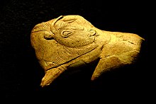
Prehistoric artifact found at La Madeleine in Tursac


Tursac | |
|---|---|
 A general view of Tursac | |
 Coat of arms | |
 Tursac  Tursac | |
| Coordinates: 44°58′12″N 1°02′43″E / 44.97°N 1.0453°E | |
| Country | France |
| Region | Nouvelle-Aquitaine |
| Department | Dordogne |
| Arrondissement | Sarlat-la-Canéda |
| Canton | Vallée de l'Homme |
| Government | |
| • Mayor (2020–2026) | Michel Talet [1] |
| Area 1 | 17.71 km2 (6.84 sq mi) |
| Population (2021)
[2] | 332 |
| • Density | 19/km2 (49/sq mi) |
| Time zone | UTC+01:00 ( CET) |
| • Summer ( DST) | UTC+02:00 ( CEST) |
| INSEE/Postal code |
24559 /24620 |
| Elevation | 56–237 m (184–778 ft) (avg. 79 m or 259 ft) |
| 1 French Land Register data, which excludes lakes, ponds, glaciers > 1 km2 (0.386 sq mi or 247 acres) and river estuaries. | |
Tursac (French pronunciation: [tyʁsak]) is a commune in the Dordogne department in Nouvelle-Aquitaine in southwestern France. Abri de la Madeleine is the site of Magdalenian prehistoric finds.

Population
| Year | Pop. | ±% |
|---|---|---|
| 1962 | 192 | — |
| 1968 | 217 | +13.0% |
| 1975 | 238 | +9.7% |
| 1982 | 263 | +10.5% |
| 1990 | 316 | +20.2% |
| 1999 | 340 | +7.6% |
| 2008 | 319 | −6.2% |
See also
References
- ^ "Répertoire national des élus: les maires". data.gouv.fr, Plateforme ouverte des données publiques françaises (in French). 2 December 2020.
- ^ "Populations légales 2021" (in French). The National Institute of Statistics and Economic Studies. 28 December 2023.
Wikimedia Commons has media related to
Tursac.
| International | |
|---|---|
| National | |
|
| This Dordogne geographical article is a stub. You can help Wikipedia by expanding it. |
Tursac | |
|---|---|
|
A general view of Tursac | |
|
Coat of arms | |
Tursac Tursac | |
| Coordinates: 44°58′12″N 1°02′43″E / 44.97°N 1.0453°E | |
| Country | France |
| Region | Nouvelle-Aquitaine |
| Department | Dordogne |
| Arrondissement | Sarlat-la-Canéda |
| Canton | Vallée de l'Homme |
| Government | |
| • Mayor (2020–2026) | Michel Talet [1] |
| Area 1 | 17.71 km2 (6.84 sq mi) |
| Population (2021)
[2] | 332 |
| • Density | 19/km2 (49/sq mi) |
| Time zone | UTC+01:00 ( CET) |
| • Summer ( DST) | UTC+02:00 ( CEST) |
| INSEE/Postal code |
24559 /24620 |
| Elevation | 56–237 m (184–778 ft) (avg. 79 m or 259 ft) |
| 1 French Land Register data, which excludes lakes, ponds, glaciers > 1 km2 (0.386 sq mi or 247 acres) and river estuaries. | |
Tursac (French pronunciation: [tyʁsak]) is a commune in the Dordogne department in Nouvelle-Aquitaine in southwestern France. Abri de la Madeleine is the site of Magdalenian prehistoric finds.
Population
| Year | Pop. | ±% |
|---|---|---|
| 1962 | 192 | — |
| 1968 | 217 | +13.0% |
| 1975 | 238 | +9.7% |
| 1982 | 263 | +10.5% |
| 1990 | 316 | +20.2% |
| 1999 | 340 | +7.6% |
| 2008 | 319 | −6.2% |
See also
References
- ^ "Répertoire national des élus: les maires". data.gouv.fr, Plateforme ouverte des données publiques françaises (in French). 2 December 2020.
- ^ "Populations légales 2021" (in French). The National Institute of Statistics and Economic Studies. 28 December 2023.
Wikimedia Commons has media related to
Tursac.
| International | |
|---|---|
| National | |
|
| This Dordogne geographical article is a stub. You can help Wikipedia by expanding it. |