La Roque-Gageac | |
|---|---|
 La Roque-Gageac and the Dordogne River | |
 Coat of arms | |
 La Roque-Gageac  La Roque-Gageac | |
| Coordinates: 44°49′38″N 1°11′00″E / 44.8272°N 1.1833°E | |
| Country | France |
| Region | Nouvelle-Aquitaine |
| Department | Dordogne |
| Arrondissement | Sarlat-la-Canéda |
| Canton | Sarlat-la-Canéda |
| Government | |
| • Mayor (2020–2026) | Jérôme Peyrat [1] |
| Area 1 | 7.17 km2 (2.77 sq mi) |
| Population (2021)
[2] | 430 |
| • Density | 60/km2 (160/sq mi) |
| Time zone | UTC+01:00 ( CET) |
| • Summer ( DST) | UTC+02:00 ( CEST) |
| INSEE/Postal code |
24355 /24250 |
| Elevation | 60–218 m (197–715 ft) (avg. 80 m or 260 ft) |
| 1 French Land Register data, which excludes lakes, ponds, glaciers > 1 km2 (0.386 sq mi or 247 acres) and river estuaries. | |
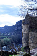
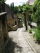
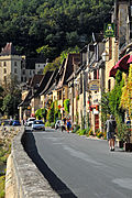
La Roque-Gageac (French pronunciation: [la ʁɔk ɡaʒak]; Occitan: La Ròca de Gajac) is a commune in the Dordogne department in Nouvelle-Aquitaine, southwestern France.
Perched above the river Dordogne, the village is a member of the association Les Plus Beaux Villages de France ("The most beautiful villages of France").
Population
| Year | Pop. | ±% |
|---|---|---|
| 1962 | 406 | — |
| 1968 | 357 | −12.1% |
| 1975 | 373 | +4.5% |
| 1982 | 404 | +8.3% |
| 1990 | 447 | +10.6% |
| 1999 | 449 | +0.4% |
| 2008 | 412 | −8.2% |
| 2018 | 426 | +3.4% |
See also
References
- ^ "Répertoire national des élus: les maires". data.gouv.fr, Plateforme ouverte des données publiques françaises (in French). 2 December 2020.
- ^ "Populations légales 2021" (in French). The National Institute of Statistics and Economic Studies. 28 December 2023.
- Views of La Roque-Gageac
-

-
 La Roque-Gageac
 -
-
-


.JPG)


| International | |
|---|---|
| National | |
|
| This Dordogne geographical article is a stub. You can help Wikipedia by expanding it. |
La Roque-Gageac | |
|---|---|
|
La Roque-Gageac and the Dordogne River | |
|
Coat of arms | |
La Roque-Gageac La Roque-Gageac | |
| Coordinates: 44°49′38″N 1°11′00″E / 44.8272°N 1.1833°E | |
| Country | France |
| Region | Nouvelle-Aquitaine |
| Department | Dordogne |
| Arrondissement | Sarlat-la-Canéda |
| Canton | Sarlat-la-Canéda |
| Government | |
| • Mayor (2020–2026) | Jérôme Peyrat [1] |
| Area 1 | 7.17 km2 (2.77 sq mi) |
| Population (2021)
[2] | 430 |
| • Density | 60/km2 (160/sq mi) |
| Time zone | UTC+01:00 ( CET) |
| • Summer ( DST) | UTC+02:00 ( CEST) |
| INSEE/Postal code |
24355 /24250 |
| Elevation | 60–218 m (197–715 ft) (avg. 80 m or 260 ft) |
| 1 French Land Register data, which excludes lakes, ponds, glaciers > 1 km2 (0.386 sq mi or 247 acres) and river estuaries. | |
La Roque-Gageac (French pronunciation: [la ʁɔk ɡaʒak]; Occitan: La Ròca de Gajac) is a commune in the Dordogne department in Nouvelle-Aquitaine, southwestern France.
Perched above the river Dordogne, the village is a member of the association Les Plus Beaux Villages de France ("The most beautiful villages of France").
Population
| Year | Pop. | ±% |
|---|---|---|
| 1962 | 406 | — |
| 1968 | 357 | −12.1% |
| 1975 | 373 | +4.5% |
| 1982 | 404 | +8.3% |
| 1990 | 447 | +10.6% |
| 1999 | 449 | +0.4% |
| 2008 | 412 | −8.2% |
| 2018 | 426 | +3.4% |
See also
References
- ^ "Répertoire national des élus: les maires". data.gouv.fr, Plateforme ouverte des données publiques françaises (in French). 2 December 2020.
- ^ "Populations légales 2021" (in French). The National Institute of Statistics and Economic Studies. 28 December 2023.
- Views of La Roque-Gageac
-
-
La Roque-Gageac
-
-
-
| International | |
|---|---|
| National | |
|
| This Dordogne geographical article is a stub. You can help Wikipedia by expanding it. |