Tivadar | |
|---|---|
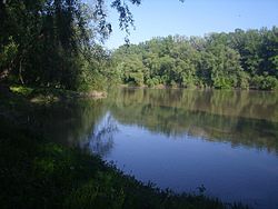
 Tisa River in Tivadar, Hungary. | |
| Coordinates: 48°04′N 22°31′E / 48.067°N 22.517°E | |
| Country | |
| Regions | Northern Great Plain |
| County | Szabolcs-Szatmár-Bereg |
| District | Fehérgyarmat District |
| Government | |
| • Mayor | Danó Sándor |
| Area | |
| • Total | 4.80 km2 (1.85 sq mi) |
| Population (2022) | |
| • Total | 166 |
| • Density | 35/km2 (90/sq mi) |
| Time zone | UTC+1 ( CET) |
| • Summer ( DST) | UTC+2 ( CEST) |
| Postal code | 4921 |
| Area code | 45 |
| Website | http://www.tivadar.hu |
Tivadar is a village in Szabolcs-Szatmár-Bereg county, in the Northern Great Plain region of eastern Hungary.
Name
Tivadar is a Hungarian version of the name Theodore.
Geography
It covers an area of 4.80 km2 (2 sq mi) [2] and has a population of 166 people according to the 2022 census. [3]
History
The name Tivadar first appeared in the papal tithe register in 1333. [4] It was already a prosperous settlement in the 14th century, owned by the Gulácsi family.
In 1428 the Petneházi family and in 1435 the Jármi family also owned the settlement. In 1551, Demeter Oroszi also received a share as a royal gift. In 1566, the village was destroyed by the Tartar auxiliaries of the Turks. In 1599, the Transylvanian princely councilor Miklós Zólyomi of Alesi acquired a share of the land by exchange. Between 1600 and 1676 several of its owners were recorded. In 1800, the families of Kölcsei, Szarka, Vincze, Gacsályi and Matolcsi, among others, had a larger estate here.
Economy
References
- ^ "Képviselő-testület, bizottság". Tivadar Község Honlapja (in Hungarian). Retrieved 9 April 2024.
- ^ "Detailed Gazetteer of Hungary". www.ksh.hu. Retrieved 9 April 2024.
- ^ "Census 2022". Census 2022. Retrieved 9 April 2024.
- ^ Lehoczky, Tivadar (1882). Beregvarmegye monographiája (in Hungarian). Pollacsek Miksa. p. 767. Retrieved 9 April 2024.
Tivadar | |
|---|---|
 Tisa River in Tivadar, Hungary. | |
| Coordinates: 48°04′N 22°31′E / 48.067°N 22.517°E | |
| Country | |
| Regions | Northern Great Plain |
| County | Szabolcs-Szatmár-Bereg |
| District | Fehérgyarmat District |
| Government | |
| • Mayor | Danó Sándor |
| Area | |
| • Total | 4.80 km2 (1.85 sq mi) |
| Population (2022) | |
| • Total | 166 |
| • Density | 35/km2 (90/sq mi) |
| Time zone | UTC+1 ( CET) |
| • Summer ( DST) | UTC+2 ( CEST) |
| Postal code | 4921 |
| Area code | 45 |
| Website | http://www.tivadar.hu |
Tivadar is a village in Szabolcs-Szatmár-Bereg county, in the Northern Great Plain region of eastern Hungary.
Name
Tivadar is a Hungarian version of the name Theodore.
Geography
It covers an area of 4.80 km2 (2 sq mi) [2] and has a population of 166 people according to the 2022 census. [3]
History
The name Tivadar first appeared in the papal tithe register in 1333. [4] It was already a prosperous settlement in the 14th century, owned by the Gulácsi family.
In 1428 the Petneházi family and in 1435 the Jármi family also owned the settlement. In 1551, Demeter Oroszi also received a share as a royal gift. In 1566, the village was destroyed by the Tartar auxiliaries of the Turks. In 1599, the Transylvanian princely councilor Miklós Zólyomi of Alesi acquired a share of the land by exchange. Between 1600 and 1676 several of its owners were recorded. In 1800, the families of Kölcsei, Szarka, Vincze, Gacsályi and Matolcsi, among others, had a larger estate here.
Economy
References
- ^ "Képviselő-testület, bizottság". Tivadar Község Honlapja (in Hungarian). Retrieved 9 April 2024.
- ^ "Detailed Gazetteer of Hungary". www.ksh.hu. Retrieved 9 April 2024.
- ^ "Census 2022". Census 2022. Retrieved 9 April 2024.
- ^ Lehoczky, Tivadar (1882). Beregvarmegye monographiája (in Hungarian). Pollacsek Miksa. p. 767. Retrieved 9 April 2024.


