Tijgerkreek | |
|---|---|
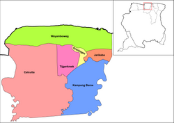
 Map showing the resorts of Saramacca District. Tijgerkreek | |
| Country | |
| District | Saramacca District |
| Area | |
| • Total | 241 km2 (93 sq mi) |
| Population (2012)
[1] | |
| • Total | 3,244 |
| • Density | 13/km2 (35/sq mi) |
| Time zone | UTC-3 (AST) |
Tijgerkreek is a resort in Suriname, located in the Saramacca District. Its population at the 2012 census was 3,244, the majority being Javanese, and East Indian. [1] The resort is mainly agricultural. In the 21st century, there has been an emphasis on peanuts. The development of a modern agricultural centre is being planned. [2]
The resort is named after the creek Tijgerkreek which is a tributary of the Saramacca River, [3] however the main settlement is Sidoredjo which was incorporated as a village in 1937. [4]
References
- ^ a b "Resorts in Suriname Census 2012" (PDF). Retrieved 27 May 2020.
- ^ "STRUCTUUR ANALYSE DISTRICTEN 2009-2013" (PDF). Planning Office Suriname (in Dutch). Retrieved 27 May 2020.
- ^ "Binnenlandse Berigten". De West-Indiër (in Dutch). 29 July 1874. Retrieved 23 June 2022.
- ^ "Gewestelijk bestuur". Suriname : koloniaal nieuws- en advertentieblad (in Dutch). 22 May 1939. Retrieved 23 June 2022.
Tijgerkreek | |
|---|---|
 Map showing the resorts of Saramacca District. Tijgerkreek | |
| Country | |
| District | Saramacca District |
| Area | |
| • Total | 241 km2 (93 sq mi) |
| Population (2012)
[1] | |
| • Total | 3,244 |
| • Density | 13/km2 (35/sq mi) |
| Time zone | UTC-3 (AST) |
Tijgerkreek is a resort in Suriname, located in the Saramacca District. Its population at the 2012 census was 3,244, the majority being Javanese, and East Indian. [1] The resort is mainly agricultural. In the 21st century, there has been an emphasis on peanuts. The development of a modern agricultural centre is being planned. [2]
The resort is named after the creek Tijgerkreek which is a tributary of the Saramacca River, [3] however the main settlement is Sidoredjo which was incorporated as a village in 1937. [4]
References
- ^ a b "Resorts in Suriname Census 2012" (PDF). Retrieved 27 May 2020.
- ^ "STRUCTUUR ANALYSE DISTRICTEN 2009-2013" (PDF). Planning Office Suriname (in Dutch). Retrieved 27 May 2020.
- ^ "Binnenlandse Berigten". De West-Indiër (in Dutch). 29 July 1874. Retrieved 23 June 2022.
- ^ "Gewestelijk bestuur". Suriname : koloniaal nieuws- en advertentieblad (in Dutch). 22 May 1939. Retrieved 23 June 2022.
