Noord | |
|---|---|
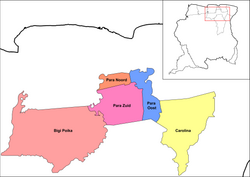
 Map showing the resorts of Para District. Noord | |
| Country | |
| District | Para District |
| Area | |
| • Total | 236 km2 (91 sq mi) |
| Population (2012)
[1] | |
| • Total | 9,703 |
| • Density | 41/km2 (110/sq mi) |
| Time zone | UTC-3 (AST) |
Noord is a resort in Suriname, located in the Para District. Its population at the 2012 census was 9,703. [1] Noord is mainly an agricultural area, and has a school. [2]
The main town in the Noord resort is Onverwacht which is also the capital of the District. [3] The indigenous village of Bernharddorp is one of the larger settlements in the resort. The village has a population of about 1,800 people as of 2020, [4]
References
- ^ a b "Resorts in Suriname Census 2012" (PDF). Retrieved 27 May 2020.
- ^ "STRUCTUUR ANALYSE DISTRICTEN 2009-2013" (PDF). Planning Office Suriname (in Dutch). Retrieved 27 May 2020.
- ^ "Distrikt Para". Suriname.nu (in Dutch). Retrieved 13 May 2020.
- ^ "Dorpen en Dorpsbesturen". Vereniging van Inheemse Dorpshoofden in Suriname (in Dutch). Retrieved 4 February 2020.
Noord | |
|---|---|
 Map showing the resorts of Para District. Noord | |
| Country | |
| District | Para District |
| Area | |
| • Total | 236 km2 (91 sq mi) |
| Population (2012)
[1] | |
| • Total | 9,703 |
| • Density | 41/km2 (110/sq mi) |
| Time zone | UTC-3 (AST) |
Noord is a resort in Suriname, located in the Para District. Its population at the 2012 census was 9,703. [1] Noord is mainly an agricultural area, and has a school. [2]
The main town in the Noord resort is Onverwacht which is also the capital of the District. [3] The indigenous village of Bernharddorp is one of the larger settlements in the resort. The village has a population of about 1,800 people as of 2020, [4]
References
- ^ a b "Resorts in Suriname Census 2012" (PDF). Retrieved 27 May 2020.
- ^ "STRUCTUUR ANALYSE DISTRICTEN 2009-2013" (PDF). Planning Office Suriname (in Dutch). Retrieved 27 May 2020.
- ^ "Distrikt Para". Suriname.nu (in Dutch). Retrieved 13 May 2020.
- ^ "Dorpen en Dorpsbesturen". Vereniging van Inheemse Dorpshoofden in Suriname (in Dutch). Retrieved 4 February 2020.
